S
TATE
O F
THE
C
O AST
R
EPO RT
2 0 0 3
The Natio nal ICM Strate g y and Pro sp e c ts fo r
Po ve rty Re d uc tio n
Tanzania Coastal Management Partnership
A joint iniatiative between the National Environment Management Council, the University of Rhode Island Coastal Resources Center, and the
The Natio nal ICM Strate g y and Pro sp e cts fo r Po ve rty Re d uctio n
Pro d uc e d b y
Tanzania Co astal Manag e me nt Partne rship
Pro d uc e d and d e sig ne d b y:
A. W hitne y, T. Baye r, J.Daffa , C. Mahika and J. To b e y
Dar es Salaam
August 2003
Coastal Management Report # 2002 TCMP ISBN: 9987-680-06-2
Tanzania Coastal Management Partnership Haile Selassie Road, Plot 87
P.O. Box 71686, Dar es Salaam, Tanzania, East Africa.
This publication is also available electronically on the Coastal Resources Center website at www.crc.uri.edu
A joint iniatiative between the National Environment Management Council, the University of Rhode Island Coastal Resources Center, and the
United States Agency for International Development
N
A
T
IO
N
A
LE
NV IRONMENT MANAGEM
ENT
C
O
U
N
C
IL
ACKNOWLEDGEMENTS
TCMP and its partners would like to thank the following organisations and individuals for their help in producing this document:
Dr. Magnus K. Ngoile for his leadership and vision for the coast. IUCN-TCZCDP for providing vital information on coastal monitoring.
Catharine Muir of the Community-based Marine Turtle and Dugong Research & Habitat Protection Programme for providing information on sea turtles in Tanzania.
John Kimaro of Antiquities for providing information about the Kilwa World Heritage Site.
The Geographic Information for Sustainable Development (GISD) project for their help in providing maps and images for this document.
Dr. Amani Ngusaru and the team at WWF-EAME for assisting in the production of this edition of State of the
Coast.
Allison Whitney for her inputs in editing and designing this document.
As always, we thank USAID for their support of this publication and the USAID Water Team for their support and encouragement.
Foreword
ii
Introduction
iii
C
OASTALE
COSYSTEMS& E
NVIRONMENT1
Coral Reefs 2
Greg M. Wagner
Mangrove Forests 5
Greg M. Wagner, Vedast Makota and Rose Sallema
Marine Fisheries 11
Narriman Jiddawi
Water Quality 16
Salim Mohammed
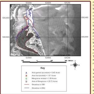
Shoreline Change 18
Alfonce Dubi
Shoreline Change Case Study of Kunduchi Shores 21
Vedast Makota and Rose Sallema
Coastal Ecosystems and Environment in the ICM Strategy 25
M
ARINEP
ROTECTEDA
REAS ANDC
ONSERVATIONE
FFORTS27
M
ARINEL
IFEASAR
ESOURCE29
Marine Mammals 30
Narriman Jiddawi
Sea turtles 32
Narriman Jiddawi and Anita Julius
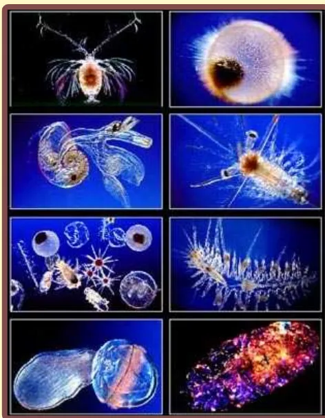
Plankton 36
Anita Julius
Seagrass 39
Charles Gaspar Mahika
Marine Life in the ICM Strategy 41
C
OASTALP
EOPLE43
Coastal Population Growth 44
Abuu Mvungi
Access to Social Services 45
Simeon Mesaki
Gender Equity and Coastal Management 47
Rose Mwaipopo & Zainab Ngazy
Coastal People in the ICM Strategy 48
E
MERGINGE
CONOMICO
PPORTUNITIES49
Seaweed Farming 50
Charles Gaspar Mahika
Coastal Tourism 51
Ildefons Masekesa
Economic Opportunities in the ICM Strategy 57
The Way Forward
59
FOREWORD
I am delighted to introduce the second report on the state of our coastal environment and its resident citizenry.
State of the Coast is a biannual publication that provides a panoramic reflection on coastal Tanzania and its
people as well as the condition, trends and threats of coastal and marine resources. The series further recommend management measures necessary for sustainable utilisation of the resources. This year’s report coincides with the recently adopted and launched National Integrated Coastal Environment Management (ICM) Strategy. Consequently, the report has drawn inferences from the ICM Strategy to make recommendations on conservation and sustainable utilisation of resources as a means by which the coastal society in Tanzania can fight against poverty.
Tanzania is endowed with 1424 km of coast that houses nearly three-quarters of Tanzania’s industries and is home to over a quarter of the country’s population. Coastal people’s occupations include artisanal and commercial fishing, seaweed farming, terrestrial crop farming, industrial production, livestock farming and gleaning for wild seaweed, sea cucumbers, cowries, cockles and other molluscs. Furthermore, the ocean supports marine parks such as Mafia and Mnazi Bay, and several Marine Reserves, which attract a burgeoning number of tourists. Additionally the sea provides resources for ports, maritime commerce and offshore gas extraction. Unsurprisingly, the coast contributes about one-third of the country’s national gross domestic product (GDP). The coastal area is important in many additional ways. Ecologically, it supports a number of natural systems, including coral reefs, mangrove forests, estuaries, beaches, seagrass beds, seaweed and terrestrial forests. Of special note is Saadani National Park that borders the ocean north of Bagamoyo town. These diverse ecosystems harbour the potential to increase food supply and create means of livelihood and income, therefore contributing to the fight against poverty especially to the poorest of the poor - coastal communities. There are several not easily quantifiable ecological services that the coast offers to its human population which include aesthetic and cultural amenities, fish nurseries and storm surge protection, to name a few.
In view of its importance, the coast deserves special attention. It remains indisputable that our coastal resources are under mounting pressures from those who depend on them for their livelihoods. It is therefore of utmost importance that we accumulate and apply the best scientific information and skills to make sound recommendations for management and sustainable utilisation of resources. This report, which contains contributions from experts in marine sciences and coastal zone management, provides information in a way that is concise and easy to read. As such, this report provides essential information for integrating science with society while implementing the national ICM strategy.
Finally I wish to thank all who made this document possible, including the United States Agency for International Development, the Coastal Resources Center of the University of Rhode Island, the World Wide Fund for Nature (WWF) and the staff and experts of the Tanzania Coastal Management Partnership. I thank the field-based coastal management initiatives such as Tanga Coastal Zone Conservation and Development Program (TCZDP), Rufji Environment Management Project (REMP), Mafia Island Marine Park (MIMP), Kinondoni Integrated Coastal Management Project (KICAMP), the PEW Foundation and all those who contributed input to this report. I congratulate the National Environmental Management Council for its leadership in supporting this effort.
This report highlights the status, issues, and threats to the coastal and marine environment and the direct and indirect links to human welfare essential for policy decisions to manage natural resources in a sustainable and effective manner. State of the Coast Report 2003 is an update, but it is not just a new edition of the same material. There will be familiar sections to those of you who have read the previous edition, but there are also new areas of interest and new issues that have come to the forefront. These changes reflect the evolving environment in which coastal management takes place.
Perhaps the greatest of such changes is the National Integrated Coastal Environment Management Strategy that was adopted by the Government in 2002 and its focus on using coastal resources in a sustainable manner to alleviate poverty. The strategy aims toward improving decision-making, promoting and strengthening sectoral management, promoting local coastal management programs, and meeting regional and international commitments such as the Nairobi Convention, the Convention on Biological Diversity and the UN Framework Convention on Climate Change. The ICM Strategy links the coastal and marine environment and poverty reduction in Tanzania with the goal of identifying long-term management options for poverty alleviation, food security, and marine conservation. Furthermore, the ICM Strategy places great importance on the involvement of local stakeholders in the management of coastal resources. These issues are the focus of this edition of the
State of the Coast with chapters offering an overview of how the ICM Strategy relates to these specific resources.
Another change is the new section about “Emerging Economic Opportunities”, which we hope to expand during coming years. This part of the report gives information about the up and coming industries in coastal areas which have definite room for expansion and further development. The two industries highlighted in this edition are seaweed farming and coastal tourism.
The section devoted to “Marine Life as a Resource” has been expanded to identify more marine resources and to further explain their importance to coastal ecosystems. Many areas have been identified for development as possible activities for generating income for coastal peoples. This is also true of the resources and issues presented in “Coastal Ecosystems & Environment”, though this section focuses more on the management measures which are required for the sustainable use of the coastal resources. Similarly, “Coastal People” emphasises the human impact on the coastal environment and identifies specific activities and issues which need management.
This section provides an overview of the diversity and abundance of natural resources and globally important ecosystems along Tanzania’s coastline—including coral reefs, mangrove forests and marine fisheries. Additionally, the effects of water quality and shoreline change are examined in depth. The human pressures that threaten the long-term integrity of these natural endowments and management actions to address them are highlighted. These include over-fishing and over-harvesting of resources, pollution from industry and cities, clear-cutting of forests, destructive fishing techniques and coral bleaching. With proper management, it is likely that the coastal environment can recover to full health. However, with neither management nor the introduction of sustainable practices these resources will never recover.
Coral reefs, a prominent coastal tourist attraction, have been extensively damaged by destructive fishing methods and by the global coral bleaching event of 1998. There are indications that some reefs are recovering from the bleaching event, but regrowth of corals damaged by fishermen has not been recorded. Conservation efforts in Tanga, Mafia and Zanzibar have succeeded in that coral cover in protected areas has increased. However, because of increasing fishing pressure, the use of destructive fishing techniques and further coral beaching incidents, it is projected that reefs in Tanzania will decline in area of coverage and overall health.
Mangrove forests, which support coral reefs, have also been damaged from over-harvesting and clear-cutting practices. Studies in Bagamoyo and Kilwa showed that the forests were in adequate condition, though the one in Bagamoyo consisted primarily of very young trees, and both areas are under high cutting pressure. The Rufiji mangrove forest is in the best health with the highest species diversity and greatest coverage by trees. The mangrove forests in Dar es Salaam, on the other hand, were very degraded due to extensive over-harvesting. Without immediate measures to protect these forests they will likely be lost.
Marine fisheries provide income and food to coastal peoples. However, overfishing and destructive fishing is a problem everywhere. Inshore fishing effort has roughly doubled in less than 20 years. We know with considerable certainty that the inshore fishery of mainland Tanzania and Zanzibar is overexploited and that shallow reefs are degraded. Fish abundance in most locations has declined significantly in the last decade, while fishing effort has increased. With essentially no deep-sea fishery, the pressure exerted on fragile inshore coral reef ecosystems is severe and persistent.
Water quality, key for all activities from swimming to fishing, is deteriorating. This is due largely to industrial and municipal waste, as well as runoff of chemicals from farming activities. In most places, levels of harmful chemicals are below FAO/WHO limits, though they are continuing to increase. The greatest immediate threat has been identified as the rapid urban population growth rate since waste from large cities is one of the largest sources of water pollution.
Shoreline change in Tanzania has been varied throughout the coastal regions. While there is no update about the overall condition of the shoreline, a case study of the Kunduchi Beach area is available as an example of what changes have been occurring. Both erosion (loss of land area) and accretion (gain of land area) have been reported in this area. Several efforts to control erosion by hotels along the northern shoreline were unsuccessful and many buildings have been damaged or destroyed. Monitoring and management of shoreline change is an important process as it can help identify and reduce the impact on areas of high risk.
C
ORAL
R
EEFS
Coral reefs are tropical, shallow-water ecosystems that have very high productivity and biodiversity. Hard corals, which produce calcium carbonate as they grow, are the main building blocks of these ecosystems. A few other organisms, such as coralline algae also
contribute to reef building. The variable topography of the reef structure creates numerous microhabitats which, in turn, support a high diversity of algae, seagrass, sponges, sea anemones, soft corals, crustaceans, gastropods, bivalves, echinoderms, fish and marine turtles.
numerous small islands along the coast of mainland Tanzania and Zanzibar as well as along many sections of the coastline. Numerous patch reefs are scattered along the continental shelf. The greatest concentrations of well-developed coral reefs are along the coast of Tanga, Pemba, Unguja, Mafia, Kilwa (Songo Songo Archipelago) and Mtwara.
These are critical habitats due to their ecological and socio-economic importance. Besides having high productivity and biodiversity, coral reefs provide shelter as well as feeding, breeding and nursery grounds for a great variety of invertebrates and fish. Thus, coral reefs play a role as keystone ecosystems in the ocean by providing ecological services that extend far beyond their area of coverage. The health or degradation of coral reefs greatly affects the well being of surrounding seagrass beds, intertidal zones, and mangrove forests as well as the plankton and nekton (fish, large crustaceans, sharks, sea turtles and marine mammals) communities in the open ocean. In addition, coral reefs protect the coast from strong wave action and thus help to prevent shoreline erosion.
Due to their ecological importance, coral reefs also have great economic importance, supporting 70% of the artisanal fish production in Tanzania. In addition, coral reefs are one of the most important tourist attractions in Tanzania, bringing foreign currency into the country. At the same time, due to the uniqueness, complexity and high biodiversity of coral reefs they have significant educational and scientific value.
Previous Condition and Threats (as of 2001)
As of 2001, though there were relatively pristine reefs in some parts of the country, many had been degraded, particularly in the shallower depths of 1-10 m. Reefs near urban centres such as Dar es Salaam, Tanga, Zanzibar and Mtwara were the most degraded. Though dynamite fishing was greatly reduced in the late 1990s, it appears that this destructive practice is now on the rise in many parts of the country, such as Dar es Salaam. The dragging of seine nets over coral reefs continues unchecked. Fortunately, coral mining, which has devastated many reefs in Mtwara has been,
C
ORAL
R
EEFS
LHC-Live Hard Coral which indicates the health of the reef; the higher LHC coverage of the seafloor, the better the reef’s health.
Rubble-Dead pieces of broken up coral that litter the sea floor.
Excellent condition-76-100% LHC
to a large extent, controlled in that district, though it still goes on in a few other parts of the country such as Mafia.
Tanga
The Tanga Coastal Zone Conservation and Development Programme (TCZCDP) has been implementing interventions in six management areas, with one of the interventions being the closure of selected reefs to fisheries for a certain period of time. Since these management areas began, they have been conducting reef monitoring every six months. In general, LHC cover remained stable in closed reefs of management areas that had started recently (2000/2001), and actually increased in some of the older management areas (started in 1998). However, in open reefs coral cover decreased considerably in the more recently established management areas. (TCZCDP unpublished).
The coral bleaching event of 1998 caused significant reduction in coral cover and led to a great increase in sea urchins. Triggerfish, one of the main predators of sea urchins, reappeared soon after the interventions, resulting in a reduction in sea urchins in some of the management areas. This indicates a recovery in the
overall health of the reef ecosystems.
Zanzibar
A recent study on reefs around Unguja highest on the reefs near Zanzibar town on the western side, except for Chapwani (see below). The reefs on the southwestern side of Unguja near Menai Bay had lower LHC cover (12-29%),
Results of coral reef monitoring (Mohammed et. al., 2002) were different at Chapwani and Changuu near Zanzibar town, where LHC cover fell only slightly between 1994 and 1999 and then rose to around 50% in 2002. Dead coral cover, though low, rose somewhat in 2002 to approximately 10% at both reefs. This data indicates that the health of the reefs is worsening, albeit at a slow rate. At Chumbe, a marine protected area somewhat further from Zanzibar town, LHC cover dropped between 1994 and 1999 but then rose in 2002 to almost match the level of 1994, covering nearly 50%.
Bagamoyo
Community-based monitoring was recently conducted on the landward side of Mwambakuni, which is the only large patch reef in Bagamoyo and is the main fishing ground for most of the villages in Bagamoyo. The study indicated that there is fair LHC cover (30%)
Fig. 2: Materials used in dynamite fishing. Other destructive fishing methods include seine net dragging, smashing coral with poles to frighten fish into nets and prawn trawling.
Coral Bleaching
The coral bleaching event of 1998 caused widespread death of corals all along the coast of Tanzania and elsewhere in the world. Coral bleaching refers to the phenomenon whereby hard corals turn white due to the death and loss of the pigmented microscopic algae (plants) that live symbiotically in the tissues of the coral polyps (animals). The bleaching is mainly caused by a rise in seawater temperature and, to a lesser extent, by the drop in salinity and increase in turbidity, all of which are often associated with El Nino.
LHC cover rose by 19% in Boza-Sange, an old management area. It decreased by 9% in Deepsea-Boma, a recently established management area.
and a diversity of other organisms. However, there is also a substantial amount of dead coral (24%), which may be attributed primarily to the coral bleaching event of 1998. There is also a significant amount of recently bleached coral that was still alive at the time the observations were made.
Dar es Salaam
Most of the fringing reef in the Dar es Salaam Marine Reserve System (DMRS) consists of coral rubble, largely covered with algae, dead coral, seagrass and sand, except for patches of good LHC growth on the Northeast and Southwest sides of Pangavini Island. The degradation was attributed to a combination of dynamite fishing, seine net dragging and the coral bleaching event of 1998.
A study along the landward side of Fungu Yasin (also in DMRS), revealed several patches of LHC, intermittent with rubble and sand, at a site on the Northwest side of the reef. On the Southwest side, there was a large area that consisted almost entirely of coral rubble with some rock and sand. In between these two sites, the seafloor cover consisted of rubble, seagrass and sand. This reef is severely degraded. The rubble at Fungu Yasin was probably a result of a combination of coral bleaching, dynamite fishing and seine net dragging.
A recent study at Kendwa Island reef, 4 km south of the Dar es Salaam harbour, showed that there was good diversity and abundance of live hard corals (51% cover) and soft corals (39% cover) on the exposed seaward reef slope. This area is naturally protected from the impacts of destructive fishing practices. On the other hand, on the shallow, sheltered back reef, where daily dragging of seine nets still takes place, coral cover was only 2%, while rubble was 66%! (Mchome 2002)
Mafia
Coral reef monitoring indicated that, from 1999 to 2001, LHC cover decreased at Msumbiji, from approximately 30% to 25% while decreasing only
slightly at Utumbi. During the same period LHC cover rose at Tutia from approximately 15% to 20%. At all three sites, dead coral and soft coral cover decreased (Mohammed et. al., 2002).
Kilwa
There was high abundance and diversity of fish at many of the Kilwa reefs, particularly Mwamba wa Songo, Msangamla, Mwanamkaya and Amana. The high percentage of rubble and dead coral on many of these reefs can be attributed both to coral bleaching and past years of dynamite fishing and dragging seine nets.
〈In Msangamla Bay on the Southeast side of Kilwa Kisiwani, the dominant seafloor category was rubble with some LHC, dead coral, rock, seagrass and soft coral also present.
〈Sanji ya Kati, a patch reef located about 3 km south of Kilwa Kisiwani, had only a low percentage of LHC cover, due to the fact that it is not a continuous reef, but has areas of seagrass and algae between patches of LHC. There was also a high percentage of dead coral and rubble.
〈Mwamba wa Songo, located on the Northeast side of the Island of Songo Mnara, was the most interesting reef surveyed, with a high percentage of LHC, though there was also a significant coverage of dead coral. The reef is very attractive because of the great diversity of live hard corals and associated reef organisms such as soft corals, gorgonians, sea anemones, giant clams and fish.
〈The Southern and Eastern sides of Mwanamkaya, which is located in the Songo Songo Archipelago had substantial percentages of LHC and dead coral, as well as significant percentages of algae, soft coral and rubble.
Projected Trends
Due to the on-going threats of increased fishing pressure, combined with the destructive fishing practices used, there is likely to be further deterioration of the coral reefs of Tanzania, unless drastic and decisive measures are taken to curtail these practices.
Coral bleaching is likely to become an even more serious threat. Due to global warming, the frequency and severity of coral bleaching events is likely to increase. The extent of the degradation that might be
Transplanted fragments of the hard coral Galaxea, translocated from Mbudya to Fungu Yasin, increased in diameter and height by an average of 2.7 and 0.4 cm per month, respectively (Peter 2003).
caused by future coral bleaching events is quite unpredictable, but the impacts could be profound on the future health of coral reefs and the abundance of the resources.
Management Options
There are several management options that could be taken in relation to coral reefs. First of all, the complete elimination of all destructive fishing practices would be a very big step in coral reef conservation. This would require the concerted effort and collaboration of all stakeholders. At the same time, fishermen should be encouraged to undertake environmentally friendly practices on a regulated and sustainable basis.
The temporary (e.g., 1 year) closure of reefs on a rotating basis, such as has been practised in Tanga, seems to be a good management option that could be adopted in other parts of the country. The decision to close certain reefs should be done by the fishermen themselves, with environmental managers only creating awareness and facilitating discussion. Otherwise, the fishermen are unlikely to adhere to the closure.
Ecotourism should be further developed as an alternative or supplementary income-generating activity and as a means of motivating communities to protect and restore their environment. In many reefs where degradation is severe, active intervention is necessary to return the ecosystem to its original state in a reasonable length of time so that resource users can gain benefits as soon as possible. Otherwise, such reefs may take decades to recover or may never recover at all. At the same time restoration helps to maintain coral diversity.
Involvement of community members in monitoring their own environment is another important aspect. Though the data gathered by the community may not always be of the highest quality, their involvement can result in gathering large quantities of reasonably reliable data and, perhaps more importantly, it enhances a feeling of ‘ownership’ amongst the community members and motivates them to implement conservation measures.
Prospects for Poverty Alleviation
If coral reefs in Tanzania could be restored to their pristine condition, this could have a great positive impact on the economy of coastal communities, due to both improved fisheries and greater benefits from tourism. The involvement of coastal people in ecotourism, with increased numbers of tourists, could greatly improve their economic well being.
M
ANGROVE
F
ORESTS
Mangroves are salt tolerant trees or shrubs that form the major component of the complex tropical and subtropical mangrove ecosystems. These ecosystems occupy the intertidal zone, primarily in muddy, sheltered areas of the coast such as bays, inlets, estuaries, channels and the leeward sides of islands. They sometimes cover vast areas in large river deltas. The other components of mangrove ecosystems include algae; marine fauna living in the mud, on the bases of the trees and in the tidal water; and terrestrial animals living in the tree canopy.
Mangrove forests are found in all coastal districts of Tanzania. There are eight species of mangroves in mainland Tanzania and a ninth species from Zanzibar. The largest continuous mangrove forests
are in the districts of Rufiji, Kilwa, Tanga-Muheza, and Mtwara.
Remote sensing, as used to create Fig. 2, has been identified as an effective tool to study otherwise difficult-to-reach and difficult-to-penetrate mangrove forests along coastal areas. Comparison of data from 1990 and 2000 shows that there has not been a dramatic change in mangrove area. However, a small decrease in the overall area of mangrove coverage did occur.
While mangrove coverage declined in the districts of Rufiji, Kilwa and Mkuranga it increased slightly in other districts. The area covered by mangroves in mainland Tanzania was approximately 109,593 ha from 1988-1990 and about 108,138 ha in 2000 (Wang et. al., 2002).
Similar to coral reefs, mangrove forests are also considered critical habitats with great ecological and socio-economic value. They are also keystone ecosystems in that they have high productivity, producing large quantities of organic matter that serve as food for many organisms. This includes those living within the forest and also outside it, since much of the organic matter produced is exported to other areas of the marine environment. Mangroves also serve as feeding, breeding and nursery grounds for a great variety of invertebrates and fish, many of which move out into the ocean during their adult stages. In addition,
mangroves filter river water and facilitate the settlement of sediments, which would otherwise be detrimental to surrounding seagrass beds and coral reefs. Mangroves also play an important role in stabilising the coastline, thus preventing shoreline erosion.
Economically, mangroves are a source of firewood, charcoal, building poles, materials for boat construction, tannin and traditional medicines. Moreover, mangrove forests serve as great tourist attractions and have important scientific value.
Previous Condition and Threats (as of 2001)
During past decades, degradation of mangroves occurred in many parts of the country. Besides a decrease in the area coverage of mangroves, there was also considerable decrease in the density, height and canopy cover of the mangroves within the forests. The areas hardest hit were those near urban centres, such as Maruhubi in Zanzibar, Kunduchi, Mbweni and Mtoni in Dar es Salaam and forests around Tanga town. Less accessible areas such as Rufiji remained largely pristine.
M
ANGROVE
F
ORESTS
Fig. 2: Mangrove forests in Tanzania with enlargements of key regions. Enlargements are as they appear in Landsat images. The presence of mangroves is denoted by the maroon color.
Fig. 3: Comparison of Mangrove Areas (in Hectares), 1990 and 2000. Salt crust areas were sections of the mangrove forests cleared for salt harvesting. They are not included in the mangrove vegetation area.
Coastal Districts
1990 Mangroves 2000 Mangroves
Mangrove Vegetation
Salt Crust Areas
Mangrove Vegetation
Salt Crust Areas
Tanga and Muheza 9,217 4 9,313 23
Pangani 3,799 0 3,879 0
Bagamoyo 5,039 0 5,051 0
Dar es Salaam (Ilala, Kinondoni & Temeke)
2,494 0 2,516 0
Kisarawe 4,159 102 4,092 75
Rufiji 49,799 1,169 48,030 2,361
Kilwa 21,826 720 21,755 797
Lindi 4,034 183 9,458 21
Mtwara 9,226 183 9,458 402
Increased awareness and conservation efforts have resulted in some recovery of mangrove forests, especially in Tanga (with collaboration from Tanga Coastal Zone Conservation and Development Programme), Lindi and Mtwara.
The major immediate causes of mangrove forest degradation were the over-harvesting of mangroves (46%) for firewood, charcoal-making, building poles and boat-making and the clear-cutting of mangrove areas (30%) for aquaculture, agriculture, solar salt works, road construction, urbanisation and hotel construction. The underlying cause of mangrove degradation was the lack of alternative resources such as other cheap firewood or land. Near urban centres, various types of pollution,
including municipal sewage, garbage and oil pollution also posed a threat.
Condition and Threats (2003 Update)
The information presented in the following sections comes from studies of the mangrove ecosystems conducted in three
sites in each forest. By measuring the characteristics of the forest in multiple sites, it is believed that a more accurate picture of the ecosystem’s health can be attained. The surveys found the mangrove forests in Bagamoyo and Kilwa to be in good condition, though the forests in Bagamoyo primarily consisted of very young trees, and both areas are under high cutting pressure. The Rufiji mangrove forest is in the best health with the highest species diversity and greatest coverage by trees. The forests in Dar es Salaam, on the other hand, were very degraded due to extensive over-harvesting. Without immediate measures to protect these same as they were in the past.
At Chengeni kwa Bwanakozi, there was a very high density of natural seedlings, with a good density of trees and a fewer number of saplings. At Ruvu kwa Mtailend, there was a large number of seedlings, but quite a low density of trees and almost no saplings. Ruvu kwa Chenipembe had the fewest number of seedlings of the three sites, but had intermediate density of trees and saplings.
Density-the number of trees per metre square
Seedlings-mangrove plant less than 1 m tall with seed coat still visible and no proper bark.
Saplings-mangrove plant between 1 and 2 m, typically between 1 and 2 years old, and is not able to fruit.
Mature trees-mangrove plant usually greater than 5 m with the ability to reproduce.
Stump basal area-the amount of ground (at ground level) covered by stumps, measured
in cm2 per m2.
Stand basal area-the amount of ground (at ground level) which is covered by stands of
trees, measured in cm2 per m2.
Fig. 4: Satellite image of mangrove coverage in Bagamoyo.
Mangrove Species Preferred Habitat
Avicennia marina Exposed area facing the sea
Bruguiera gymnorrhiza
Middle of the mangrove forest extending into the landward area
Ceriops tagal Inner part of mangrove forest on well drained soil
Heritiera littoralis River banks, tidal estuaries and mangrove swamps
Lumnitzera
racemosa Saline and dry areas
Rhizophora
mucronata Tidal stream, river banks and estuaries
Sonneratia alba Mudflats in sheltered locations and estuaries with slowmoving water
Xylocarpus
granatum Upper portion of river banks and dry areas
There is significant on-going cutting pressure, with 5-10 stumps per 25-m2 plot being observed in the three
sites. It appears that Ruvu kwa Mtailend has been subjected to the highest cutting pressure in past years and thus many of the stumps observed came from large trees.
Dar es Salaam
The mangrove forest at Mtoni Kijichi shows considerable degradation. Due to mangrove harvesting, over a period of just a few months the density of mature trees dropped from 0.06 to 0.04 individuals per m2, stand basal area
decreased from 24 to 7 cm2
per m2 and stump basal area
rose proportionally. Moreover, saplings and seedlings were completely absent from the Sonneratia zone due to fishermen dragging seine nets under the tree canopy. Thus, this forest is in danger of being lost unless remedial measures are taken (Akwilapo 2001).
Community-based monitoring has been undertaken at Mbweni and Kunduchi. Baseline data reveals that natural seedlings are abundant, but very few mature trees or saplings are present. At Mbweni, the community transplanted a significant number of R. mucronata seedlings (some of which are now saplings), while the Kunduchi community had transplanted C. tagal seedlings.
Though the number of mangrove species was greater in Kunduchi (six) than in Mbweni (four), the evenness component of species diversity was much higher in Mbweni than Kunduchi, making an overall greater species diversity in Mbweni than in Kunduchi. Higher species diversity indicates a healthier ecosystem.
The mangroves of Mbweni and Kunduchi have been more severely degraded than forests in other parts of the country described in this update, as indicated by the sparseness of mature trees and saplings as well as
the very low basal area. However, these forests are regenerating reasonably well as indicated by the high number of natural and transplanted seedlings. Nevertheless, there is no regeneration of some species and greater efforts are needed to fully restore these forests in terms of mangrove abundance and species diversity.
In Dar es Salaam, interviews with the villagers at Mbweni and Kunduchi indicated that the main reasons for cutting mangroves in Mbweni and Kunduchi are over-harvesting for use as firewood (mentioned by 25% of the interviewees), construction poles (16%) and charcoal-making (12%) as well as clear-cutting for building sites and commercial projects (19%) (Wagner et. al., 2001). In Mbweni, a large area was clear-cut for the construction of a hotel and another area for solar salt pans, both of which never materialised. These destructive activities have been somewhat reduced
Fig. 6: Satellite image of mangrove coverage in Mtoni Kijichi.
Mangrove Regrowth in Cleared Areas
A comparison between cleared and forested areas of mangroves at Mbweni indicated that sediment organic matter (needed as nutrients for the trees) was significantly higher and seafloor, or land, animals, particularly crabs, were more abundant in the forested areas than the cleared areas. Transplanted seedlings showed better survival/ health status in the forested areas than the cleared areas. The poor survival in cleared areas was attributed mainly to the extreme temperatures, salinity levels and desiccation that occur there, as well as low organic matter content. These findings demonstrate that the practice of clear cutting has significant impacts on the environmental characteristics of the forest and makes replanting difficult.
since 2002, but there are still occasional incidences of people clear cutting certain patches of the mangrove forests for construction purposes. There is also some harvesting for firewood and building poles, though at a low level. good balance between mature trees and regenerating seedlings and saplings at all sites assessed. In general, the Kilwa mangroves have higher density than forests in Bagamoyo and Dar es Salaam, particularly with respect to mature trees and saplings.
The number of mangrove species represented at the various sites ranged from four to six. The best representation of mangrove species occurred at Kilwa Kivinje and Mtoni, i.e., the evenness component of species diversity was highest at these sites. The other three sites were dominated by Ceriops tagal, with reasonably good representation of Rhizophora mucronata at Matapatapa and Somonga.
The highest cutting pressure was observed at Matapatapa (6 stumps per 25-m2 plot), which is a
significant proportion of the number of trees per plot (an average of 20). At other sites, there were less than 3 stumps per plot. Despite the reasonably adequate density of mangroves in most areas, there were certain small patches within these forests where there had been recent high cutting pressure and substantial degradation.
In Kilwa district, present threats include harvesting for domestic firewood, building poles, fence-making and firewood for salt making, and activities at landing sites and clear-cutting for solar saltpans. Digging under mangrove trees to collect fish bait, which usually results in the death of the tree, is another current threat. Mangrove resource utilisation at sites in Kilwa appears to be sustainable. However, Kilwa Kisiwani, Kilwa Kivinje and Mataptapa the utilisation is not sustainable because the above-mentioned impacts are very severe.
Rufiji
The Rufiji mangrove forest is the largest in East Africa. As such, it is the most highly developed mangrove ecosystem in Tanzania.
As in Kilwa, a one-time assessment was conducted at selected sites in Rufiji, with community participation. • At Kifuma, all eight mangrove species found in mainland Tanzania were present. Mangrove density was relatively low since the trees were large in size. There was a high number of Avicennia marina seedlings, but modest number of seedlings of other species.
Fig. 7: Satellite image of mangrove coverage in Kilwa.
Fig. 8: The density of seedlings, saplings and trees (mean + standard error) of all mangrove species in study sites in Kilwa.
0
Kisiwani Kivinje Mtoni Matapatapa Somanga
D i
Figure 9: Total density of stumps (mean + standard error) of all mangrove species found in the study sites.
Kisiwani Kivinje Mtoni Matapatapa Somanga
• There was a partly due to the fact that villagers had planted large numbers of C. tagal seedlings in areas that had formerly been cut for rice cultivation.
〈At Matosa, the s t r e s s - t o l e r a n t Avicennia marina dominated (3.9 and 4.5 trees and seedlings per 25-m2
plot, respectively), with only 0.06 Ceriops tagal trees per 25-m2 plot and no other species present.
This is due to the fact that water only reaches this area for a few weeks per year during the principal rainy season when the river is flooded.
Total stand basal area at Kifuma, Atakae and Matosa were 1261, 738 and 282 cm2 per 25-m2 plot,
respectively. Kifuma showed higher basal area than any other sites reported herein. This is to be expected since Rufiji is the most highly developed mangrove forest in Tanzania and in eastern Africa.
Projected Trends
Due to increased awareness about the importance of mangroves and mangrove replanting efforts, which have been promoted by the Mangrove Management Project (MMP) as well as various local ICM programmes and NGOs, it is likely that the condition of the mangrove forests of Tanzania will improve considerably over the next few years. The positive impacts of replanting can be observed within only a few years.
Management Options and Their Implementation
In addition to the awareness campaigns and other
management efforts that are being implemented, greater community management should be encouraged through various ICM programmes, marine parks and the MMP. For example, through participatory decision-making, communities can completely close certain mangrove areas that require recovery and allow harvesting on a sustainable basis in other areas that are already well-developed forests. Another possibility is that communities can decide to divide certain degraded areas into plots and allocate them to specific groups or individuals for replanting. If their replanting efforts are satisfactory, they could be allowed to harvest their plots on a sustainable basis once the mangroves have grown sufficiently. These approaches would help to motivate coastal people to restore and protect the mangrove forests.
While some efforts have been made to restore mangrove forests in degraded areas, much still needs to be done. With the involvement of villagers in replanting, the workforce is greatly increased and a feeling of “ownership” is created amongst the communities. Relatively minor efforts in restoration can have great positive impacts on mangrove forests.
Ecotourism, where the local communities are fully involved, can be an effective way of motivating communities to protect and even restore their mangrove forests. In fact, planting mangroves can be an integral part of the ecotours as is done in Mbweni, with both tourists and villagers participating.
Since one of the greatest demands on mangroves is for energy in the form of firewood and charcoal, rural electrification, fuel-efficient stoves and the use of biogas could help to relieve the pressure on mangroves.
Proper Environmental Impact Assessments (EIAs) must be conducted before the establishment of all salt works, aquaculture projects and construction of any kind, to be sure that proper areas are selected and environmentally friendly procedures are followed. Often the natural salt flats on the upper edges of mangrove forests can be used for these purposes with minimal negative impacts.
Prospects for Poverty Alleviation
Mangrove forests are a rich source of fuel, building
M
ANGROVE
F
ORESTS
poles, and materials for boat making, all of which are important to the livelihood of coastal people. The easy availability of these items precludes the necessity of spending money on procuring them elsewhere and thus alleviates poverty. If there is a high enough level of conservation and on-going replanting of mangroves, these resources could be harvested on a sustainable basis for the economic benefit of the local communities. Sustainable harvesting of mangroves for sale is a legal way to generate income.
In addition, mangroves provide nectar for large populations of bees and therefore bee-keeping is an economic activity that can be more fully developed in mangrove forests. Ecotourism, besides being a way of conserving mangrove forests, can also provide significant income to the local communities that are involved. Moreover, well-preserved mangrove forests help to maintain fisheries production, not only in the rivers within the forests, but also in the surrounding coastal waters. Thus there are many ways in which the mangrove forests can contribute to the alleviation of poverty.
M
ARINE
F
ISHERIES
The demand for fish in Tanzania is progressively increasing, particularly with the greater the number of people living along the coast and with the expansion of tourism activities. This increased demand for fish
products has raised the prices substantially, which has enlarged the incomes of some people in the fisheries trade. However the fishing industry is still 95% artisanal as the majority of the local fishermen still use traditional fishing methods.
Most of the fishermen are poor and thus despite profit opportunities, they have not been able to adjust to the i n c r e a s e d
demand. Most of the fisherfolk use simple gear and vessels with l i m i t e d operational range. These vessels include dugout canoes, outrigger canoes, dhows and small boats. They are
normally driven by sails but can be fitted with outboard engines. The operational range of a vessel is determined by its size and whether it is sail or motor-driven. Vessels driven by sails rarely travel further than four km from shore. Their fishing gear includes traps, hook-and-line, nets and spears. The fishermen have good ecological knowledge about the marine ecosystems, which they use in their day-to-day activities, especially since their fishing pattern is affected by tides and guided by the monsoons. Fishing is practised throughout the year but the peak season is during the Northeast monsoon (November to April) when the ocean is calmer and clearer.
Fish resources caught by these fishermen which are of special significance includes the pelagic, or surface-living, species such as the sardine, jack, swordfish, mackerel, kingfish and tuna. The groups that dominate the marine demersal, or deeper, catches are bream, grouper, parrotfish, snapper, rabbitfish, and emperor. These are caught using hand lines, traps and nets. The small pelagic species consist primarily of sardine, small tuna and mackerel. These are mainly caught by purse seines or ring nets. Other species include octopus and lobster that are usually collected by hand from reef flats at low tide or by divers. Prawn and shrimp are caught in seines in estuarine waters, particularly at the mouths of large rivers. Sea cucumber and cockle are gathered at low tide in the intertidal flats. Squid are
Fig. 1: Artisanal fishing boats in Bagamoyo.
mainly caught using hand lines, seine nets or fixed nets. Other species that are caught include sharks and rays. The crab catches in Tanzania are dominated by two species, both of which are of c o m m e r c i a l
Most coastal people are involved in fishing activities. Nearly all fishing takes place on the continental shelf which is quite narrow. It reaches about 4 km offshore, with the exception of the Zanzibar and Mafia channels where the shelf extends for some 60 km. The area of the shelf to the 200 m depth contour for both mainland and Zanzibar combined is 30,000 km2.
This is the area commonly used by the artisanal fishermen.
Hand, stick and spear fishing occurs in the intertidal areas at depths of 0 –1.5 m. Most other types of artisanal fishing, including hand lines and seine nets, occurs in shallow waters rarely exceeding depths of 60 metres. SCUBA divers collecting sea cucumber and other molluscs can reach a depth of up to 35 metres. Trawling for prawns is usually conducted at depths between 4-10 m though some few vessels do occasionally trawl in deeper waters.
The inshore marine fishery is extremely important to coastal communities in Tanzania. The number of fishermen is increasing. Currently it is estimated that there are over 60,000 fishermen operating along the whole coast of Tanzania including the islands. Most of the fishing is conducted by poor, artisanal fishers, often on shores with marginal soil productivity and with few
economic alternatives. The importance and impact of the fishing extends much beyond these full-time fishers, and includes all those involved in boat construction and repair, and marketing and sale of fish products. Therefore when a fishery collapses it does not only affect the fishermen but a whole group of people who are dependent on it. Fish is also an important source of animal protein to a large part of the coastal population.
The high seas, or the “Exclusive Economic Zone” that extends 364 km (200 miles) out to sea, is so far unexploited by local fishermen because of the lack of suitable vessels to venture into these distant waters. However there are many unofficial reports that a few big foreign licence vessels fish in these waters.
Prawn fisheries represent the only industrial-scale marine fishery in the country, and has been operating since the mid 1980’s. The industrial fishery for prawns is based mostly in the inshore shallow areas around the mangrove fringed Bagamoyo/Saadani and the
Rufiji Delta with a fleet of approximately 25 prawn trawlers. Offshore fisheries are a potential resource with high value migratory fish species such as tuna, sailfish, marlin and swordfish. Foreign industrial vessels are also known to fish these waters. Few vessels are licensed.
The total annual catch of Tanzania’s marine fisheries is around 70,000 t. Zanzibar alone currently lands about 22,000 t. The total annual catch for mainland Tanzania still ranges between 48,000 t to 56,000 t.
M
ARINE
F
ISHERIES
Stakeholders in the marine fisheries include:
Tourism and sport fishing personnel including boat captains and crew and guides
Fishermen and their suppliers including fuel and ice suppliers, credit suppliers, gear manufacturers and boat builders
Bulk buyers, fish exporters and retailers
1980 1982 1984 1986 1988 1990 1992 1994 1996 1998 2000 2002 Years
Previous Condition and Threats (as of 2001)
Natural calamities such as storms and strong waves are known to damage coral reefs and indirectly could affect fish populations. Other impacts could be caused by river runoffs, which could create siltation effects especially around river mouths. A recent event was the coral bleaching caused by the increase in water temperatures in 1998. This is believed to have impacted coral reefs in several parts of Tanzania with one of the effects being a change in fish species composition.
Much of the pressure on fisheries and degradation of reef ecosystems has been caused by destructive fishing methods. By far the most destructive type of fishing is the use of dynamite. Dynamite fishing was once widespread, but its use has been reduced drastically throughout the country. It has been practiced in Tanzania for over 40 years. Each blast of dynamite instantly kills all fish and most other living organisms within a 15-20 m radius and completely destroys the reef habitat itself with a radius of several meters. With numerous blasts occurring daily on reefs all over the country, over a period of many years, the cumulative effect has been devastating. Before 1995, Mafia Bay was reported to be like a “war zone” with blasts going off every hour.
The use of small mesh seine nets to capture fish on the bottom and around reefs is almost as destructive as the use of dynamite. The nets are weighted and dragged through the reef flat or are pulled around coral reefs. Dragging them over the reef flat unavoidably damages coral and other marine life. Some techniques involve beating and smashing coral colonies with poles to frighten fish into the net. The small-mesh size of seine nets results in the capture of many juveniles. Capture of juvenile fish, when conducted intensively in nursery areas, results in depletion of fish stocks, alteration of species composition, loss of species diversity, and disruption of food webs.
The fish landings and catch per unit effort seemed to be declining slightly. However, overall fishery resources appear to have reached the upper level of exploitation. Some resources were affected more than others. For example in the small pelagic fisheries of Zanzibar, the catch drastically declined from 600 t in 1986 to 91 t in 1997 (Jiddawi 2000).
Traders also claimed that the sizes of some sea products such as the sea cucumbers had decreased, but they still continued to buy them due to demand and competition. In the long line fisheries the catch rate in numbers and weight in most parts of the West Indian Ocean region including Tanzania, declined drastically. Shark fin trade also declined and some species are rarely seen now in Tanzania waters.
Other resources that showed a decline were the octopus and squid populations, which contribute about 6% of the total catch. In addition to consumption by local markets, pressure was also being exerted on octopus fishery bay the tourist industry, since octopus meat is very popular in tourist hotels and restaurants. A lot of octopus is also exported to neighbouring Kenya, where there is a ready market.
Condition and Threats (2003 Update)
Almost all people in coastal communities are involved in fishing activities in one form or another. The average individual consumption of seafood in the country is 13 kg/year in Tanzania mainland and 22 kg/year for Zanzibar.
Tanzania’s exports of marine products include shrimp, sea cucumber, shells, lobsters, crabs, squid, octopus and sardines. However, the majority of export revenue comes from the harvest of shrimp or prawns (kamba).
One of the indicators of the status of a fishery is the change in species composition and/or change in size of the fishes. These are important components in evaluating trends in fisheries. In the southern part of Zanzibar where the villagers used to practice local conservation systems (which in recent years has collapsed), it has been observed that although the fishermen’s catch is large, the fish are of a much smaller size than before.
In the case of prawns, it is believed that the resource has reached the upper level of exploitation. In early 1988, 13 trawlers were landing about 2000 t of prawns and 25 trawlers are currently landing half of this (Nhwani et. al., 1993 and Bwathondi et. al., 2002).
to the villages where the fishermen live. However fishermen migrate to other areas during monsoon seasons.
There is currently ongoing Regional monitoring, control and surveillance programme which started in 2001. The programme is designed to assist development of Tanzanian ideas for the improvement of Monitoring, Control and Surveillance (MCS) in our marine waters in order to improve management of marine fisheries resources. There are also plans now to increase national sea fishery inspectorate capacity, national onboard observer capacity, as well as data and information management. This is an advance in Tanzania’s marine fisheries, especially in relation towards the management of deep-sea fisheries.
Shrimp trawl fisheries, particularly for tropical species, generate more by-catch and discards than any other fishery type, accounting for over one third of the global total. In Tanzania, the annual prawn landings are associated with about 80% by-catch in weight, which includes juveniles of commercial fish species and other marine organisms that include endangered species like the sea turtles. Also, prawn trawling destroys seafloor ecosystems and it is likely that prawn trawlers have been compromising nursery grounds.
In the Rufiji delta, conflicts exist between the trawler operators, the artisanal fishermen and other stakeholders. Sources of conflicts between artisanal and trawl fishermen arise from destroyed nets, apportioning of fishing grounds and dumping of trash fish by the trawlers offshore which is often swept on the beach, fouling the artisanal fishery landing sites. Trawlers also damage artisanal fishing equipment thus heightening conflicts between them.
The use of destructive fishing methods has decreased, but is still practised in some areas. Using these techniques leads to indiscriminate destruction of fish breeding and nursery grounds and has seriously affected populations by destroying fish larvae and juveniles. Most of the destructive fishing methods are illegal, but continue to be used due to lack of enforcement and competition for marine harvests.
Mangrove cutting and loss of mangrove habitat has a similar impact on fisheries. The forests are an irreplaceable part of the fish life cycle, providing
nursery and breeding grounds for many ecologically and economically valuable fish and prawn species.
Indications are that the fish supply will not be able to keep up with the projected increased demand. The supply gap is challenged by external factors such as human population growth, domestic and industrial pollution, competing demands for the same resources and the overriding but unknown consequences of global climate change. While difficult to predict specific outcomes, the impact of these changes will further reduce the potential growth in fisheries.
Projected Trends
There are possibilities for Tanzania to expand its fish production by focusing on the pelagic stocks, especially sardines and tunas, in the Exclusive Economic Zone (EEZ). Since 1997, industrial long liners have caught 193 metric tons per year of tuna and other fish in Tanzania’s EEZ.
Due to the on-going threats of increased fishing pressure, combined with the destructive fishing practices used there is likely to be further deterioration of the coral reefs of Tanzania unless drastic and decisive measures are taken.
As mentioned in the section on coral reefs, the frequency and severity of coral bleaching events is likely to increase due to global warming. Such events are expected to have serious consequences with respect to the future health of coral reefs and the abundance of their resources, though the extent of the degradation that might be caused is unpredictable.
Management Options and Their Implementation
A comprehensive research and monitoring programme on marine resources is required to determine the status, distribution, abundance and value of the resources so as to obtain baseline information for comparison in future studies. Also, such in depth monitoring of the landings will generate better relationships with the fishing community.
Monitoring the size frequency of prawns caught in the Rufiji delta is a way to make recommendations on mesh
size of net regulations. Also, detailed studies of the industrial fishery will help to understand the overall contribution of immature prawns to the catches from the Rufiji delta.
Public education and awareness campaigns must be conducted to raise and improve the general public’s knowledge of fishery laws and their justification. There must also be promotion of good practices, such as avoiding the capture or collection of juveniles thereby allowing them to grow to maturity.
Community-based marine reserves and protected areas should be established in order to conserve and restore marine diversity and fish populations. These programs cangenerate income from responsible tourism and build awareness of the need for conservation.
There is a long history of traditional conservation or management in some coastal villages in Tanzania. This has included seasonal octopus closures in the southern Unguja Villages and restrictions on moving fishers (dago) fishing in Menai Bay. They have also included the reservation of village-front fishing grounds for elders and the creation of special fishing areas that can only be fished to generate money for collective communal activities like special celebrations. These latter two forms have been in practice at Bweleo, Uzi, and Fumba. Encouragement of such traditional management could assist in reducing overexploitation of fishery resources.
In view of the nature of the fisheries in many parts of the country and the capacity at government level in Tanzania it is recommended that the co-management route for coastal fisheries be done. Those will involve the sharing of responsibilities between the government and local resource users to manage the resources.
Prospects for Poverty Alleviation
The national fisheries policy recognises the role of small-scale fishermen who catch most of the fish consumed locally as well as for export market. Therefore it aims at promoting, developing and exploiting the fish sustainably in order to provide food employment and income to fishermen.
Most of the fishermen along the Tanzanian coast are
poor as a result of various problems they face in relation to capture and marketing of their products. One of the biggest problems is reaching the markets due to poor roads especially during the rainy season. Improvement of roads could assist in increasing the income of fishermen.
Improving and encouraging the use of appropriate technologies in the post harvest handling and processing of fish could improve the shelf life of fish and fish products for local consumption and export. In addition, modernising fish landing sites could assist in alleviating this problem and increase the income of
fishermen. There is also poor distribution of credit facilities to enable the fishermen to improve fishing vessels and equipment.
Encouraging export of fish and fishery products so as to meet the requirements of the international markets is one method of advancing the fight against poverty. Furthermore, to ensure the resources are preserved, fishing under-utilised areas such as deep sea or expanding aquaculture practices could be practiced. Also, proper management of all human activities that affect fisheries could help to reverse past trends in fisheries decline and improve the livelihood of the coastal communities.
Additionally, fishermen know the location of most of Tanzania’s fishing grounds. However, to what extent these reefs are utilised in terms of fishing effort and the seasons during which they are visited still needs investigation in order to be able to make policy decisions.
W
ATER
Q
UALITY
Good water quality is an important prerequisite for virtually all social and economic activities that occur in or around the aquatic environment including both marine and freshwater ecosystems. For example, economic activities like fishing and aquaculture are only viable in an environment that is free from contagion that may arise from pollution or other contaminants. Similarly, tourism and other leisure activities are especially sensitive to an aquatic environment that is deemed to be of poor quality. Of major local concern is the health impact of poor water quality. Pollution of water bodies resulting from improper discharge of waste such as sewage, solid waste and industrial and agrochemicals has serious consequences on the health of communities living in the vicinity of or using food resources from such areas.
Water quality can also be reduced by the introduction of sediments and other material resulting from natural events such as storms and floods but also through poor use of the land. Tanzania loses an estimated 10 to 100 metric tons of soil and silt per hectare annually.
Poor land-use practices both inland and in coastal areas negatively affect water quality. This includes large-scale clearing of forests and grasslands, agricultural practices of overgrazing and mining. Such practices result in more rapid runoff, leading to soil erosion and increased sedimentation in coastal areas causing the reduction in quality of coastal waters. This has a direct impact on the natural environment. Excessive sediment loads in the water column reduce light penetration such that light dependent plants are unable to survive. Moreover, high sediment loads smother corals and other organisms resulting in their deaths.
Similarly, drainage of irrigated farms and subsequent discharge of such water into coastal waters may
contaminate these waters with excessive nutrients and pesticide residues. Coastal habitats, such as mangroves and coral reefs, are easily degraded by excess loading of agricultural discharges as well as sewage borne nutrients and organic matter. Eutrophication, also resulting from excess nutrients, causes degradation of water quality through oxygen depletion and general organic over-loading.
Previous Conditionand Threats (as of 2001)
Previous studies on water quality in Tanzania have shown that the quality of coastal waters in most parts of the country is relatively good. The exceptions were the water bodies fronting major cities and towns such as Tanga and Dar es Salaam, on the mainland, and Zanzibar Town in Zanzibar. In Dar es Salaam, waste from domestic and industrial sources had created pollution hot spots in the harbour area and other locations around the city’s waterfront. Untreated sewage from Zanzibar Municipality was discharged directly into coastal waters and this had been reported to cause local pollution. Excess discharge of nutrient-laden waters from a fertiliser factory as well as from municipal sources and discharge of effluents from sisal processing factories were the principal cause of water quality degradation in the coastal waters of Tanga. As a result, proliferation of macroalgae caused by such pollution was a common feature of the municipality.
In Zanzibar Town coastal waters were reported to have alarming levels of both feacal and total coliform bacteria – far beyond the internationally accepted levels for safe bathing. Nutrient levels were also higher than normal. Discharge of untreated wastewater into the coastal environment was principally responsible for the observed water quality degradation in the waters fronting the town.
Dar es Salaam, being the most populous city in Tanzania, generated the most waste in the country. Domestic sewage was the principal source of pollution in the city’s coastal waters, especially the harbour area. The pollution originating from the discharge of untreated waste from the sewer system, pit latrines, soak pits, small landfill sites and garbage dumps may have found their way into the coastal waters. As a result
W
ATER
Q
UALITY
of this pollution, high levels of nutrients and faecal and total coliform have been recorded in coastal waters. Furthermore, heavy blooms of macroalgae are a regular feature of near shore waters especially in the vicinity of the northern end of Ocean Road beach.
Manufacturing industries were another source of pollution in Dar es Salaam. Various industrial wastes from Keko, Chang’ombe, Kurasini, Mtoni and Temeke have been discharged untreated into the shores via the Msimbazi Creek. These pollutants included chemicals from textile industries such as dyes, paint wastes and strong alkalis. Other pollutants included pesticides, heavy metals, cyanides and detergents. Oil pollution from the refinery at Kigamboni also contributed to the waste load.
The principal threat to water quality in Tanzania coastal waters stemmed from untreated municipal wastes. This was especially true in the main coastal towns and cities. The water quality outside these densely populated mainly urban areas, though largely free from the impact of domestic wastes, was under threat from agricultural run-off, pesticides and fertilizers. Water quality in these areas was threatened by chemical wastes and sediment carried to the coast by rivers, especially during heavy rains. The threat is worsened by poor agricultural activities carried out upstream, deforestation and soil erosion. A direct consequence of this is the smothering of corals and other organisms, as well the reduction of aesthetic value of the water, making it less attractive for activities such as tourism and general recreation. Poor water quality was therefore a significant threat to emerging economic activities especially to coastal tourism, which has a great potential in national development.
Another potential threat to water quality in Tanzania was that posed by petroleum exploration activities in some coastal regions. These include the Selous Basin, Rufiji River plain, Ruvu basin and Mandawa basin. Leakage of petroleum resulting from such activities could cause severe water quality degradation.
Condition and Threats (2003 Update)
Industrial and municipal waste, as well as runoff of chemicals from upstream farming activities, are the greatest sources of coastal water contamination. In most places, chemical levels are not in violation of international water quality standards, but the trend is toward increasing deterioration. The greatest immediate risk has been identified as rapid urban population growth rate since untreated sewerage from large cities is one of the largest sources of water pollution.
Since the publication of the last State of the Coast in 2001, only a few studies on water quality have been conducted in Tanzania. However, these give an indication, albeit in a small way, of the present quality of the coastal waters in some parts of Tanzania. For example, the use of pesticides is prevalent in Tanzania including in the Dar es Salaam District. In the city proper, pesticides are mainly used in horticulture. Small amounts of DDT and its derivatives have been detected in the biota and water column in various sites in Dar es Salaam that include the harbour area, R. Kizinga and estuary, R. Msimbazi and estuary, Salender and Ferry among others. However, the amount of the pesticides found (6.6 – 53 ug/kg f.w.) was significantly below the FAO/WHO maximum acceptable limits in fish and seafood, which is 200 ug/kg f.w.
Studies have indicated that some economic uses of coastal waters are themselves sources of water quality degradation. Notable among these that have been reported recently in the literature are fish culture and tourism. Diminishing oxygen concentrations in earthen mariculture ponds has been reported in Makoba Bay, Zanzibar. This has been attributed to eutrophication, which results from remineralisation of accumulated organic matter on the bottom of the ponds. Since there is a periodic but direct exchange of water between the ponds and the sea one can assume that there is at least a localised impact of mariculture activities in this area.