SMITHSONIAN MISCELLANEOUS COLLECTIONS VOLUME
121,NUMBER
1GEOLOGY OF THE SAN JON
SITE, EASTERN NEW MEXICO
(With
5 Plates)BY
SHELDON JUDSON
University of Wisconsin
(Publication 4098)
CITY OF WASHINGTON
PUBLISHED BY THE SMITHSONIAN INSTITUTION
MARCH
5, 1953SMITHSONIAN MISCELLANEOUS COLLECTIONS VOL. 121, NO. 1, PL. 1
i
AERIAL
PHOTOGRAPH OF THE SAN JON
SITE.NORTH TO
RIGHT,(Soil Conservation Service photograph.)
SMITHSONIAN MISCELLANEOUS COLLECTIONS VOLUME
121,NUMBER
1GEOLOGY OF THE SAN JON
SITE, EASTERN NEW MEXICO
(With
5 Plates)BY
SHELDON JUDSON
University ofWisconsin
(Publication 4098)
CITY OF WASHINGTON
PUBLISHED BY THE SMITHSONIAN INSTITUTION
MARCH
5, 1953BALTUIOBE, MO.,U.8. A.
CONTENTS
Page
Introduction I
General statement i
History of investigation 3
Acknowledgments 4
Physical setting of the San Jon site 5
Location of the site 5
Climate 7
Vegetation 7
General geology lO
Physiographic divisions ofeastern
New
Mexico loRocks ofthe area lo
Geologyof the San Jonsite lo
General statement lo
Origin of the San Jon depression 12
Depositsofthe San Jon site 13
Basal Sand 15
San Jon formation 18
Sand Canyon formation 21
Wheatland formation 22
Relationof cultural andfaunal materialto the deposits 23
Conclusions 25
Depressions and occupance of the Plains 26
Summary
28Pleistocene stratigraphyin the vicinity of the San Jon site 28
General statement 28
Characteristics of late Pleistocene formations 29
San Jon formation 29
Sand Canyon formation 31
Wheatland formation 31
Summary
oflate Pleistocenestratigraphyofthe Plains '. 31Tipton Canyon 32
Grapevine Canyon 32
Deadman's Canyon 33
Puerto Canyon 34
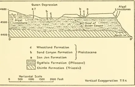
Queen Canyon 34
Landrigan Canyon 36
Hatfield Lake 36
Cover of the Plains 40
Stratigraphy of the Valley 41
Pediments 41
Sedimentationand erosion inthe Valley 42
Firepit Arroyo 43
Hodges Site 45
Mesa Redonda 45
iii
iv
CONTENTS
Page
Barranca Arroyo 46
Tucumcari Mountain 47
Blue Water Hole 47
Northwest ofSan Jon 49
Eolian material unrelated to alluvium 50
Summary
53The "Alluvial Chronology" 54
Causes of alternate sedimentation and erosion 54 Datingtheevents of the "Alluvial Chronology" 58
Geologic antiquityof the San Jon site 64
General statement 64
The SanJon level 64
"Collateral"
Yuma
level 65Clear Fork (?) level 66
Pottery level 66
Generalconsiderations 66
Bibliography 67
ILLUSTRATIONS
PLATES
Aerial photograph of San Jon site Frontispiece
Following page
I, View looking east along the northern escarpment of the Southern High Plains; 2, view looking east across the depression containing
the San Jon site 10
Photographic panorama and landscape sketch showing relation of late Pleistocene formation to the Basal Sand atthe San Jon site 10 I, Leached andunleached OgallalaformationatTipton Canyon; 2, Sand
Canyonformationfilling broad channel in the SanJon formation 18
I, Highest terrace deposits of the Wheatland formation filling channel cut in Basal Sand; 2, small clifif formed by soil developed at top of oldwind-blown sandand covered by modernblown sand 18
CONTENTS
TEXT FIGURES
Page
1. Index
map
of San Jon site and environs 62. Graph showing average monthly precipitation and temperatures re- recordedfromstations at SanJon,Tucumcari, Logan, andClovis 8
3. Physiographic
map
ofa portion ofeastern 'i^ew Mexico 11 4.Map
of the San Jon site showing location of geologic sections, photo-graphs, and archeological excavations 12
5.
Map
ofthe Southern High Plains in the vicinity of the San Jon site.. 12 6. Schematic diagram to illustrate the relation of process and form toclimate in the development of depressions 13
7. General geologic sections of the San Jon site i5 8. Geologic sections of areas of archeologic excavation at the San Jon
site 17
9. Diagrammatic sketch to show relation of cultural and faunal material to late Pleistocene deposits at the San Jon site 24 ID. Section showing relation of late Pleistocene formations tothe Pleisto-
cene "cap rock" and leached Ogallala formation at Deadman's
Canyon 33
11. Section showing relation of late Pleistocene formation to the "cap rock" and leached Ogallala formationat Puerto Canyon
25 12. Section showing relation of multiple "cap rocks" and late Pleistocene
formations to breached depression at headof Queen Canyon 35
13. Sketch
map
of Hatfield Lake 3714. Section showing relations of Pleistocene deposits along drainage ditch
southwest of Hatfield Lake 38
15. Diagram showingrelation of pediments andlate Pleistocene formations to the modern stream grade in the Valley 42
16. Section showing channel cutting intervening between upper and lower members of the Sand Canyon formation in Firepit Arroyo 44
17. Section showing sequence of deposits at the locality of archeologic
investigations in Firepit Arroyo
^
18. Section showing relation of pediments tolate Pleistocene formations at
Firepit Arroyo 45
19. Section showing relations of late Pleistocene formations at point F,
figure I 46
20. Section showing relations ofpediments and late Pleistocene formations
at Blue Water Hole 47
21. Sections showing relations of late Pleistocene deposits at point I,
figure I 49
22. Section showing relations of wind-blown sand deposits and soil zones
at Gibson ranch 51
GEOLOGY OF THE SAN JON SITE, EASTERN NEW MEXICO
By SHELDON JUDSON
UniversityofWisconsin
With
5 PlatesINTRODUCTION GENERAL STATEMENT
The
study of earlyman
inNorth America
hasmade
rapid strides sincean
unquestioned associationbetween man and
extinct animalswas
discovered nearthe smalltown
ofFolsom, N. Mex.,
a generation ago (Figgins, 1927; Cook, 1927).Much
remains to be learned, however.There
is still awide
gap, both in timeand
degree of cultural attainment,between
the huntingSandia-Folsom men and
their contemporaries, with their finely chipped implements,
and
themuch
later pottery-making Pueblo Indians. This gap, firstempha-
sized
by
Roberts (1940), begins to close asnew
findscome
to light (Kelley, Campbell,and Lehmer,
1940; Saylesand
Antevs, 1941 ;Bryan and
Toulouse, 1943;Bryan and McCann,
1943;Haury,
1943).Unfortunately these finds are widely scattered
and
usually consistof afew
stone implementswhich
tell little as to the culturalattainments of themen who made
them. Furthermore,these discoverieswere made
in soft, unconsolidated deposits
whose
datingby
the geologicmethod
is still incomplete. Consequently, the intermediate cultures
have a
status nebulous archeologically
and vague
chronologically.The San Jon
siteseemed
to present a reliable guidepost along this otherwise poorlymarked
road. Preliminary reconnaissanceproduced
stone artifacts, obviously not a part ofany
late pottery-making cul- ture.These were
associated withthe bones ofbison in stratified beds lying at the headwaters of streams having obviously terraced valleys.Furthermore, the geographic location of the site held great promise, situated as it is
between
the relativelywell-known
areas bordering the southernRocky Mountains
in Coloradoand New
Mexico,and
the great areasofstill unexplainedbut reputedly ancient stone cultures ofcentraland
western Texas.SMITHSONIAN MISCELLANEOUS COLLECTIONS, VOL. 121, NO. 1
2
SMITHSONIAN MISCELLANEOUS COLLECTIONS
VOL. 121The
geology of the site is so singular as to quicken the interest of themost
hardened investigator.Nature
has apparentlygone
out of herway
to produce a fascinating and, at first glance, indecipherable puzzle.The
site is located within a small depression inthe SouthernHigh
Plains. This depression has been breached, drained,and
dis- sected to depths of 100 feet, producing a geologist's delight, a soil conservationist's nightmare. In the exposed, stratified deposits lay the bonesand
artifactswhich drew
the archeologist to the site.At
first glance, magnificently exposed
and
varied depositsaugured
well for the geologist.They
heldhope
of representing a sequence of eventswhich would add
to our present highly inadequateknowledge
of the late Pleistocene^ history of the SouthernHigh
Plains.The
incompleteness ofthatknowledge on
the onehand and
the great dis- tance of the sitefrom
the glaciated areas of the southernRocky Mountains
on the other discounted the possibiHty of a direct tie to the glacial chronology. Nevertheless, the presence of beds clearly deposited under conditionsmore
moist thannow
exist suggested a tentative correlation with the climatic fluctuations of late Pleistocene time.The
hopes engenderedby
thepreliminary reconnaissancehave
been only imperfectly realized. Archeological investigationby
the Smith- sonian Institutionwas
confined to thesummer
of 1941.From
this preliminaryand
necessarily incomplete investigation Roberts (1942) obtained a sequence of faunas,some
ofthem
extinct,and
associated cultures. Unfortunately, these cultures are representedby
toofew
artifacts to be too helpful in
an
exact dating.The
geological work, originally plannedto extend through at least three field seasons,was
interruptedby World War
IIand
subse- quentlyreducedinscope.The
results,although theydo
notcompletelyfulfill theinitial hopes, are
by no means
inconsiderable. Conclusions have been reachedon
the following problems: (i)The
character, order,and
origin of the beds at the site; (2) the correlation of this sequence alongthenorthern edgeoftheSouthernHigh
Plains; (3) the origin of the "depression oftheHigh
Plains" in this locality; (4) the natureand
origin of the so-called "cap rock" of theHigh
Plains in this generalvicinity; (5) the correlation of the sedimentary sequence at the siteand
nearby pointson
theHigh
Plains with successive1Throughoutthis report theterm "Pleistocene"is usedinthe sense suggested by Flint (1947, p. 209). In such a sense it includes all time that has elapsed since the end of the Pliocene. The terms "Recent" and "Postglacial" are aban- doned as exact time designations and when usedhave only a local or informal connotation.
NO. I
GEOLOGY OF THE SAN JON
SITE— JUDSON
3 periods of erosionand
alluviation in local streams of theCanadian
Valley; (6) the relation of the sequence so established to climatic changes in theSouthwest
during late Pleistocene time;and
(7) the relativeand
insome
cases exact ages of the several cultural horizons within the sequence.HISTORY OF INVESTIGATION
Keith Martin, a local
ranchman,
first discovered the siteand
re- ported his find to the Laboratory ofAnthropology
at SantaFe and
tothe
Department
ofAnthropology
attheUniversity ofNew Mexico.
Dr.
Frank
C. Hibben, of the University ofNew Mexico,
with the assistance of several University students, conducted a preliminary survey of the site in the spring of 1940.Animal
bonesand some
artifacts
were
found. Itwas
soonapparent,however,thatthethorough
investigationdemanded by
the site could not be reconciled with pre- viousand
extensive archeologiccommitments
elsewhereassumed by
the University. Therefore, after a visit to the site inAugust
1940by
Dr.Frank H. H.
Roberts, Jr., inthecompany
of Dr. Hibben, the University ofNew Mexico
offered toturn over itsinterest in the site to the Smithsonian.The
offerwas
accepted,and
Roberts directedan
archeologic investigation of the siteand immediate
vicinityfrom June 20
toSeptember
6, 1941. Archeologicwork was
stoppedby
the war. Unfortunately, Dr. Robertswas
unable toresume
the investi- gation after the cessation of hostilities because of the additional ad- ministrativeburdensimposed upon him
as DirectoroftheRiver BasinSurveys
conductedunder
theadministration ofthe Smithsonian Insti- tution in cooperation with the NationalPark
Service, theCorps
of Engineers,and
theBureau
of Reclamation.The
lateDr.Kirk
Bryan,Harvard
University,accompanied Hibben and
Robertson
their visit to the site in 1940.During
the following winter, after ithad
been decided to conduct extensive archeologic investigations atSan
Jon, arrangementswere made
to provide for a concurrent geologic study. Dr.Bryan and
the writermade
a general reconnaissanceof the area during the period July6
to 16, 1941.The
writer
remained on
theground
untilSeptember
6, carryingforward
the detailed geologic investigation.Although
thewar
interrupted the continuance of the geologic field work, the results obtained during1
94
1were
checkedinthefieldby
Dr. Bryan, Dr. Franklin T.McCann, and
the writer in the periodfrom August
2^ toSeptember
11, 1943.The
writerreturned totheproblem
after thewar,spendingthe periodfrom June 30
toSeptember
i, 1947, in the completion of field work.4 SMITHSONIAN MISCELLANEOUS COLLECTIONS
VOL. 121 Dr.Bryan
again conferred in the field with the writerfrom August
10 to 15, 1947-ACKNOWLEDGMENTS
The
writer is under obligation to the officials of the Smithsonian Institutionwho
authorized the projectand
provided funds for the field studies of 1941and
1947. Dr. Roberts,by
hiscontinued interestand
support, has been a predominating influence in thisand
earlier investigations of the geologyof earlyman. The
writeris particularly indebted tohim
for the careand
skill withwhich
he discriminated between the several geologic horizons exposed in theSan Jon
exca- vations, for his adviceon
problems of correlation,and
for his per- sonal interest in the progress of the geologic study. In 1941 the hospitality of the archeologicalcamp
offeredoptimum
conditions for work.The members
of the archeological partyand
]\Irs. Roberts contributedmuch
inmaking
thecamp
ahome
forthegeologist.Bryan and
the writerwere accompanied on
the briefand
hurriedfield trip of 1942
by
Dr. Franklin T.McCann.
HerbertW.
Dick, of the ColoradoMuseum
of Natural Historyand
amember
of the 1941 archeological party, spent aweek on
needed archeologic investigation during the 1947 seasonand
devoted considerable timeand
effort in the officeprocessing the material excavated.Many
local residents contributed to thegeologicwork and
without their aid the field problemswould
have beenmany
times multiplied.Particularthanks are dueto
Wayne H.
Miles, oftheCanadian
River Soil ConservationDistrict,Tucumcari
;H. W. Mutch,
formerly resi- dent engineer of theArch Hurley Conservancy
District; HalbertN.
Knapp,
former chief,and
D.H. McLeod,
of theSouthwest Quay County
SoilConservationDistrict;and Royal A.
Prentice,Tucumcari.The
writer expresses thanks for informationand
courtesies receivedfrom M. Tom Home,
Clovis, formerly postmaster atSan
Jon;Mr.
and Mrs. James
Wilson,San Jon
;Mrs. Helen
Anderson,San Jon
;
Mr. and Mrs. Frank
Wilson,Wheatland; Guy
Fife,Tucumcari;
D. R.
Burnham, U.
S.Experiment
Station,Tucumcari; Mr. and Mrs.
Luis C. de Baca,Newkirk;
Foley Griggs,Norton; and
to themany
otherNew Mexicans who added
to the successand enjoyment
of the field work.The
writer's wife,Anne
Perrin Judson, served as field assistant during the 1947 field seasonand
provided technicaland
editorial assistanceinthepreparationof this report.The
lateProf.Kirk
Bryan,Department
of Geology,Harvard Uni-
versity, supervised this study in field
and
officefrom
its formalNO. I
GEOLOGY OF THE SAN JON
SITE— JUDSON
5 inception in 1941.His many
kindnesses, both professionaland
per- sonal, cannot berecounted.PHYSICAL SETTING OF THE SAN JON SITE LOCATION OF THE SITE
The San Jon
site is located approximately 10 miles south of thetown
ofSan
Jon,-N.
Mex.,from which
it takesitsname
(see fig. i).The town
is a local trading center of slightly over400
inhabitants.It lies
on
the Chicago,Rock
Island&
PacificRailway and U.
S.Highway
66.A paved
road. StateHighway
39, leads southfrom
the
town 44
milestoClovis,N. Mex., and
passes withinthree-quarters of a mile of thesite.The town
ofSan Jon
lies atan
elevation of 4,025 feeton
a gently rolling plain carvedby
theCanadian
Riverand
its tributaries.The
plain is part of a broad valley separating
two
great tablelands, the CentralHigh
Plains to the northand
theSouthern High
Plains, or Llano Estacado, to the south.The town
is situated in the small valley of theSan Juan
^ Arroyo,*which
flows easttoward
thetown
of
Endee
^ before turning northeastand
eventually entering theCa-
nadian River across the Stateboundary
in Texas.A
broad ridge,200
to300
feet high, intervenesbetween
theSan Juan
Valleyand
~The word sanjon is an old Spanish spelling of sanjon, a ditch. According to local tradition there was once a pool of water in the adjacent grassy flat.
Suchpools wereusuallycalledcharcosby the Spanish, butone of longand nar- rowform mighteasilybetermedaditch. Round-ups ofthe early cattledays cen- tered around the now-vanished sanjon, which gavethe modern town its name.
The present spelling is an obvious error.
3The name "San Juan" for thisarroyo appears on Soil Conservation Service maps andis doubtless a stillfurther corruptionof sanjon.
*The Spanish arriving in the
New
World found that some of the smaller drainageways carried live water but that the majority were grassy-bottomed draws, markedhere andthere by charcos, or stagnant pools ofwater. Lacking a precise descriptive term for these drainages the Spanish applied the word arroyo, which in their native land referred, and still does, to a small stream ofrunning water. It isobvious thatsuch application ofarroyo wasnot entirely correct and did not accurately describe the ephemeral streams of the area at the time of Spanish settlement.By
the end ofthe last century and the begin- ning of the presentthese same arroyos had changedtheir regimes and had be- comesteep-sided, sandy-bottomed,intermittent gullies sothat theirpresent aspectis still further removed from the original meaning of arroyo than it was dur- ing Spanish days. Despite its etymological inappropriateness the term arroyo
is universally retained throughout the Southwest to designate a wet-weather streamand its vertically walled channel.
°Endee is obviously a phonetic rendition of an old cattle brand "ND."
SMITHSONIAN MISCELLANEOUS COLLECTIONS
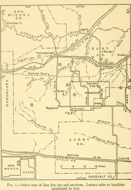
VOL. 121Fig. I.
—
IndexmapofSan Jonsiteandenvirons. Lettersrefer tolocalitiesmentioned intext.
NO. I
GEOLOGY OF THE SAN JON
SITE— JUDSON
7 theCanadian
River to the north.South
of thetown
the plain rises gently over a distance of9
miles until it butts abruptly against a bold escarpmentsome 700
feet highforming
the northernboundary
of the SouthernHigh
Plains (pi. 2, fig.i).The
differences in the topography, the vegetation,and
theeconomy
of the inhabitants of theHigh
Plainsand
the valleyare asmarked
as the escarpmentitself.Almost on
the brink of this escarpment the site occupies a position at once picturesqueand
strategic to thetwo
areas, the relativelylow
valleyplainstothenorthand
thehigherStaked Plainstothe south.CLIMATE
This section of eastern
New Mexico
has a continental, semiarid climate characterizedby
dry winters,mid- and
late-summer rainfallmaxima,
amarked
annualvariation ofprecipitation, a high percentage of clear,sunny
days, highsummer
temperatures, moderatelylow
winter temperatures,and
high evaporation. Rainfall is apt to be tor- rential, falling too quickly to be absorbedby
the soil,and
thus lostby
rapidrun-off.The
climate is remarkably similar over awide
area, a situation directly related to the lack of local topographic control.The modern
climate is directlydependent
upon
thegreat distance of the areafrom
large waterbodies capable of supplying adequatemoisture, the south- erly latitude,
and
the general uniformityof the land surface.Summary
figures of precipitation, temperature,and
evaporation for selected stations within a 40-mile radius of the site areshown
in table I. Figure 2 illustrates that precipitation follows the annualmarch
oftemperatures.VEGETATION
Even
as the climate of this section ofNew Mexico
is transitionalbetween
desertand subhumid
orhumid
climates, sois the vegetation transitional in characterbetween
desertand
true grassland.The
greater part of the area falls within the
Upper Sonoran
Life Zone, although anarrow
reentrant exhibitingLower Sonoran
elements enters the areafrom Texas and
extendswestward up
theCanadian
Riverand
along PajaritoCreek
(Bailey, 1913).In general, that part of eastern
New Mexico
here considered pos- sesses a vegetativeunity.There
areno
regionally significant changes in the distribution of plant life. Despite this unity, however, there are variations in plant geography.These
are not explicable in terms8 SMITHSONIAN MISCELLANEOUS COLLECTIONS
VOL. 121 ofmajor
climatic changes but rather in terms of local differences in elevation, bed-rock geology, surface deposits of eolian materialand
alluvium, changes in the declivity of slopesand
the position of these slopes, relative availabilityof water,and
the recent history of landuse.Of
great importance to the present study is the relation of the vegetativecover tothe variations of rainfall.During
years of plenti- ful precipitationthe grassesand
perennial flowersflourish inprofusionand
abundance.A
high percentage of theground
surface is coveredby
plantsand
the top soil is well anchoredby
their root systems.3.5-^ Temperature
r90
Fig. 2.
—
Graph showingaveragemonthlyprecipitationandtemperatures recorded from stations at San Jon, Tucumcari, Logan, and Clovis.Gullying, sheet wash,
and
deflation are arrestedby
this protectivemat
of plants. Erosion is at aminimum. During
a dry year, or a successionofdryyears, deficiencyof moisture reduces the percentage ofplant cover.Bare
patchesbetweenindividualplants orsmallgroups of plants increase inarea.The
plantsbecome
increasingly less effec- tive inprotecting theground
surfacefrom
erosionby wind and
water.Itis during such periods that gullyingis initiated.
At
thesame
time sand sources are bared to the incessantwinds and wind
erosioncom-
mences. Concurrently with deflation of source areas of sand an al-ready
weakened
vegetation in other areas is smothered beneath a blanket ofwind-moved
material.Thus
does the intimate relation between rainfalland
vegetation contribute to successive periods of stabilityand
instability ofthesurficialdeposits.NO. I
GEOLOGY OF THE SAN JON
SITE— JUDSON
So
^luoooooooooooooooo
-- woo rOVO
TtO^O
>-ig \o o lo 00
»i (N.CO IN.K.
Jg irj lO lO lO
a 6 6 O O O O O O
15 d d d d d d d d
^" N CO "^ q ovo vd lo K.
12;
^
"^ -"^^
*;voo LOTri-<ooo O\p-ioo^
ror^o
-^ootnO
W M Ci H-i M l-I Hh' l-J^- CO C>< 00 o
" d\ c\t<. d\
O
vo vo lo loU
-« §• ro lo COvq T)-CO
[/I >; i-i i-l w w c>i i-I oi
g_vq oq CO On o d d d d\
i/i f^ t>. r^
o
O
s
ti Ov »o00 CO
CL,
•2coco>-;ioO\>-<0<T)-
>-> cq <N (N oi !-< oi oi c^'
i-iC^wOjMi-iCliNOJ
>•
^
0\COmcococot%
rtcNroirjOlcoroq^
§ c>< CM oi oi c^ CO oi (N
fe
>,
10
SMITHSONIAN MISCELLANEOUS COLLECTIONS
VOL. I2lGENERAL GEOLOGY
PHYSIOGRAPHIC DIVISIONS OF EASTERN NEW MEXICO
Eastern
New Mexico
lies largely in the Great Plains Province(Fenneman,
1931).The San Jon
site is located in theHigh
Plains section, amajor
subdivision of the Great Plains Province,which
is itselfdivisible intothree unitsstretchingfrom
SouthDakota
toTexas and
here referred to as the Northern, Central,and
SouthernHigh
Plains.
The San Jon
site liesalongthenorthern escarpmentof the SouthernHigh
Plains or Llano Estacado (Staked Plains). This plain has a regional slope to the southeast.To
the north the SouthernHigh
Plains are separated
from
the CentralHigh
Plains by a series of buttesand
mesas, outliers of the Plain,and by
the broad but lower Valley Plains of the Canadian River intowhich
theCanadian
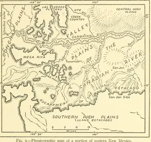
River has incised the present canyon. Figure 3shows
themajor
physio- graphicfeatures ofthe area.ROCKS OF THE AREA
The
general geology of the area is recorded in a geologiccolumn
involving pre-Cambrian,Upper
Paleozoic, Mesozoic,and
Cenozoic rocks. Beginning with the Paleozoic theserocks are exclusively sedi-mentary and
flat-lying.The
character, thickness,and
positionofthese rocks determine in largemeasure
themain
topographic featuresand
are critical in allminor
features.The
Pleistocene and, tosome
extent, the Pliocene deposits are discussed in detail in this report.
For
a detailed consideration of older rocks the reader is referred toDarton
(1922), Bates (1946),and Dobrovolny and Summerson
(1946).
GEOLOGY OF THE SAN JON SITE GENERAL STATEMENT
Viewed from
the surface oftheHigh
Plains theSan Jon
site liesin a broad, shallow depression over a mile in diameter.
The
gentle slopes of this depression are scarcely perceptible at first glance, par- ticularly if onecomes upon
itfrom
the north over the rugged relief of the "breaks" below the escarpment (pi. 2, fig. 2).The
rim of depression isalmost featureless,although a broad,low
hill eastofthe site rises slightly above the general level of the plains.To
the southand
west lieplowed
fields.The
siteand
the slopes immediately ad-SMITHSOMIAN MISCELLANEOUS COLLECTIONS VOL. 121, NO. 1, PL. 2
^
SMITHSOIMIAN MISCELLANEOUS COLLECTIONS VOL. 121, NO. 1, PL. 3
IT
b'1
r
%I^(
lu
r»'*«
r^.t'
w
•d*i
'r>=.*
S^'V;
<^^(
•V
.*N
H
pq
•-M OS
5$
^a
NO.
GEOLOGY OF THE SAN JON
SITE— JUDSON
IIjoining it are in grassy pasture land
and
the edge of the escarpmentis fringed withpinon, juniper,
and low-growing
bushes.In the center of this shallow
bowl
a crow's-foot pattern of arroyos 50 to 100 feet in depth has been fashioned (frontispieceand
fig. 4).The
threemajor
toes of the pattern point south, southwest,and
west.103°30'
LAS &\V£GAS
PLKTTEAU CENTRAL HIGH
PLAINS
"
Tucumcanf. y^n^,,^^/
San Jon ^^iv.-' ^/
''"'
-/-..vf^:!smmi/ym)\
NO\y\-"
^eiSTACADO
SanJon Site
^'L.
\
-y^: SOUTHERN
H)j6HPLAINS
\.
V
1 (.LLANO ESTACADO)X
:::iL
Fig. 3.
—
Physiographicmap
of a portion of easternNew
Mexico.These
convergetoform
a singledrainage,Sand Canyon
Arroyo,which
flows northeast through a deepnarrow
canyon. Thiscanyon
pierces the escarpmentand
the arroyo descends to the Valley Plains of theCanadian and
hencevia theSan Juan Arroyo
totheCanadian
River.The
dissected portion of the depression is almost completely con- tained within an area one-half mile in diameter. Considered in a broadway
this depression is one of several depressions lying in a grooveintheHigh
Plains as discussedbelow.12
SMITHSONIAN MISCELLANEOUS COLLECTIONS
VOL. 121ORIGIN OF THE SAN JON DEPRESSION
The
dissected depressionwhich
contains theSan Jon
site is one of several depressions lying in a broad, shallow groove in theHigh
Plains as
shown
in figure 5. Figure 5shows
also that there are other grooves in the Plains to the southand
that these also contain depressions of varying size.These
depressions,which
rangefrom
a few feetacross to wellover amile in diameterand from
afew
inches to over 50 feet in depth, are characteristic ofmuch
of theHigh
Plains surface.
It
was
necessary to determine the ageand
origin of these depres- sionsbecausethe artifact-bearingbeds of theSan Jon
siteare involved in oneof thesedepressionswhich
has been breachedby
the retreating scarp oftheHigh
Plains.A
study of the depressions, breachedand
unbreached,shows
that in this section of theHigh
Plains the depressions are the result of alternate periods of leachingand wind
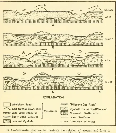
deflation (Judson, 1950).During
wet periods of the Pleistocene the calcareouscement
of the Pliocene Ogallalaformationwhich
covers theHigh
Plainswas
locally destroyedby downward-percolatingground
water.During
succeeding dry periods these locally leached areas sufferedwind
deflation. Inmany
places sand hills resultingfrom
this deflation arefound
to the east of the depressions (fig. 5). Figure 6 suggests the relation ofform and
processto theperiods of aridityand
moistureand
indicatessome
of the variations inform which might
be expected.As
noted above, the depressions are located along broad, shallow troughs.These
troughs involve, in away which
is as yet imperfectly understood, the "cap rock" of the Plains, that limestone crust at the top of the Ogallala formation or above it. Certainly, however, the depressions are notduetotruecollapse intotheunderground
althoughsome
collapsedepressions areknown from
thearea (fig. i,A
; Judson, 1950).The
initiationand
expansion of the depressionsform
a feature of the Pleistocene but cannot be confined toany
specific horizon of the Pleistocene. It is entirely reasonable that depressions have been formingon
the Plains since the end of the Pliocene.Some
have ceased togrow and
havebecome
so choked that theremay
be littlerecognizable surface expression.
Were
the surficial cover strippedfrom
the Plains,the resulting surfacewould
be literallypock-marked
with the open scars ofmodern
depressionsand
the healed or partiallyMAP
OF
THE
SAN JON SITE
EASTERN NEW MEXICO
I I
EXPLANATION
Pleistocene (Undifferentiated)
"Pliocene Cap Rock
Ogailala Formation Pliocene (Unleached)
"^tlJppldLiJJf] Purqatoire Formation
Lower Cretaceous Chinle Formation Triassic
^^eac ed Contact of Leached and (Leached/ Unleached Ogailala
Dashed line indicates inferred contact
Location of Geoloqic Sections
AREA I Location of Areas of Archeologic Excavations
Location of Photographs
Fence line
Internnittent
stream
Extent of Gullyo zoo
oo
I I
M M
feet
->^
—
Topographic Control From Survey byROBERT H.NAERRILL, 1941
lexL.
P
Miles
>Ji^
Section 29 South Fence
—
^
29,28 32T33
X X -
T9N, R34e
MAP
OF THE
SAN JON SITE
EASTERN NEW MEXICO
EXPLANATION
Q.eachcd/
Pleistocene (Undifferentiated)
"Pliocene CapRocU' Ogaliala Formation Pliocene(Unleached) Purgatoire Formation Lower Cretaceous Chinle Formation Tnassic
Contact ofLeached and Unleached Ogaliala
Dashed line indicates inferred contact
Location of Geologic Sections
AREAI Location of Areas of Archeologic Excavabions
Location of Photographs
^
—
Fence lineIntermittent stream Extent of Gully
2QO O zoo *00
feet
Topographic Control From Survey by ROBERT H NAERRILL,1941
Fig.4.
—
Map of the San Jon siteshowing location ofgeologic sections, photographs, and archeological excavations.R 34- E R 35 E.
Cap
rock"'^3 AttitudeofMesozoic
Sediments
,y
Normal fault after Dobrovolny andSummerson
(1946)\ Indicates
downthrown
side o SpringPrimary roads,oiled or gravelled
=== Secondary
roads,graded Many ungraded
but passable roads follow section linesHouses omitted Contour interval
20
feetTopography sketched from barometer traverses in
l94KJudson), 1942 (judson,Bryan and
McCamn),
l947CJudson).Datum
U.S.C. and G.5.B.M."Martin 1921," elev.
4957
feet. Base compiledfrom office sheets and air photos of 5.C.S.byJudson
34 R 35 E
f the San Jon site.
NO. I
GEOLOGY OF THE SAN JON
SITE— JUDSON
13healed scars of "extinct" depressions.
The
depression is character- istic not only of the Plains of the present but also of the past back tothebeginning of the Pleistocene.liiitTrii^^
Climate ARID
^fem^TTTlti^^
MOIST
^tTTrmrfr.^^^
ARID
MOIST
EXPLANATION
J Windblown Sand<'^*^^ Soil onWindblown Sand
^^^
Late Lake DepositsI EarlyLake Deposits
|v.'\v".{| Leached Ogallala
-Pleistocene
^'''1'^' "Pliocene Cap Rock"
|-;i;^j;;[ Ogallala Formation(Pliocene)
lililililil /Wesozoic Sediments
Lake Surface
—
* Direction of WindFig. 6.
—
Schematic diagram to illustrate the relation of process and form to climate inthe development of depressions.DEPOSITS OF THE SAN JON SITE
The
deep arroyos of the site expose a series of beds ofpond and
alluvial origin.
They
lie withinand upon
the rockswhich form
the supportof theHigh
Plains. Itis obvious that thenarrow canyon
has been cut back into the depressionwhich
itnow
drains.The
top ofA 'Cap rock"
'^j Attitudeof /V\esozoic
Sediments ,y Normal fault after Dobrovolny
and Summerson (1946)
^Indicates downthrown side o Spring
Primary roads,oiledorgravelled
"-= Secondaryroads, graded Manyungraded but passable roads follow section lines Mouses omitted terval 20feet
Topography sketched from barometer traversesin 941 Judson, .942 (judson,Bryanand McCamn), l947(Judson). Datum U.S.C and G.
SB
M.Martin 1921," elev4957feet. Base compiled from off.ce sheets and airphotosof SCS byJudson
F...5.-Mapof theSouthernU„hPlains,n thevicini,,
oftheSanJonsite
14
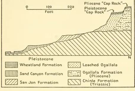
SMITHSONIAN MISCELLANEOUS COLLECTIONS
VOL. 121 the escarpment isformed by
Pliocene bedscomposed
largely of white to buff calcareous sandstone with a limy plate, the "cap rock,"at thetop.
The
Pliocene can be traced almost completelyaround
the site in asomewhat
assymetrical loop as indicated in figure 4.Within
this loop
and
overlapping it, particularly to the south, rest the beds involved in the archeological excavations.They
aresummarized
as followsand
discussed inmore
detaillater on.SUMMARY
OF THE BEDS EXPOSEDAT THE SAN JON SITEFeet
Modern deposits ofthe arroyos to 10
Periodicallymovedby flood.
disconformity
Wheatland formation 5 to 15
Low
Terrace. Base i to 5 feet above grade of arroyos. Fine gravel, sandand silt.disconformity
Intermediate Terrace 5 to 15
Base8to 10feetabovegradeofarroyos. Materials asabove.
disconformity
High Terrace 10 to 15
Base 20to25 feet above gradeofarroyos. Materials asabove.
Contains bones ofBisonbison.
No
artifacts found.disconformity
Sand Canyon formation to 50
Reddish to reddish-brown alluvium. Alternating beds of sand andclayey-humic material. Contains numerous iron-manganese nodules averaging \ inch in diameter. Lime occurs as tubules and as films particularly along joints in the clayey horizons.
Occurs in broad channels cut into underlying formations 40to 50 feet above grade of modern arroyos. Contains artifacts ("Collateral"
Yuma
andClearFork(?)),bonesofBison bison, and the planorbid Helisoma tenue sinuosum (Bonnet), a mod- ern molluskcommon
in the area.disconformity
San Jon formation to 50
Zone 3 to 45
Dark blue-gray clay grading laterally into greenish clay and intoreddishcompact sandy alluviumtoward theborders of the basin. Contains nodules andplates ofiron-manganese oxideand concretions and plates ofcalcite. Lime plates occur on lamina- tionsand onstrongvertical jointing. Bonesofextinctbisonand artifacts are found in top of the blue clay as in the planorbid Helisoma tenue sinuosum (Bonnet).
NO. I
GEOLOGY OF THE SAN JON
SITE— JUDSON
I5Zone 2 to 1.5
Discontinuous lenses of fine gray-white volcanic ash.
Zone I to 3
Crust of iron-manganese oxides, to 3 feet thick overlain by bleached white sand with claylenses to 4 feet thick; grades towardperipheryofbasininto reddish laminatedclay 5 to 8 feet thickwith green clay seams injoints. This in turn grades into reddish alluvium. Proboscidian and bison bones in the clay facies.
disconformity
Basal Sand (decalcified Ogallala) 40 to 50
Upper zone, 5 to 10 feet thick, has vertical, columnar jointing.
Calcareous concretions and iron-manganese flecks and clay- filledcracks. Lowerzone, 35to40feetthick, isabrownto buff sand without laminations. It contains vertical joints. Near the baseit has calcareousconcretions. In most places itis separated fromtheunchangedOgallalaformation byvertical contacts.
angular unconformity (hidden) Lower Cretaceous shale and sandstone.
Cross sections of these beds along general east-west
and
north- southlinesand more
detailed sectionsinthe areasofactualarcheologic excavation are presented in figures 7and
8, respectively.®The
pho- tographicpanorama and accompanying
outline sketch in plate 3 illus- tratethecomplexity of the depositsand
their relations to one another,BASAL SAND
The
BasalSand
restsunconformably on
the Purgatoire formation ofLower
Cretaceousage.The
natureof thecontact,nowhere
exposed at the site, is inferredfrom
the position of the Purgatoire in thecanyon
draining the depression inwhich
the site is located.Here
the top of the Cretaceous has
an
elevation of approximately 4,700 feetand
is overlainby
acemented and
resistant bed8
feet thickcomposed
of boulders, cobbles,and
gravelforming
the base of the Ogallala formation. This basal Pliocene conglomerateforms
the lip of afallssome
15 feet in height.The
upper limit of the Cretaceous^Geologic sections offer the most effective method of illustrating the geo- logic sequence. Areal mapping of the deposits proved unsatisfactory because of the difficulty in delimiting the deposits inplan and becauseof the large per- centage of outcrops confined to vertical or near-vertical cliffs. The original sections were made in the field on a horizontal scale of i inch to 100 feet and a vertical scale of i inch to 20 feet. Basic topographic control was obtained from a 1941 survey by Robert H. Merrill. Secondary control was developed with ahandlevel andused primarily forthe location of contacts.
i6
SMITHSONIAN MISCELLANEOUS COLLECTIONS
VOL. 121^livlii
^<
^iilil;
>BlPli
lip «p
\.
:;;::;:;;lirii||i x;:::H-'li •'
•
•::^:::I?A;I;|;i:|;
':1::.1V1;1 ili'.-
-.1::io
:-:-^:;i:4:li|S :•••:§• 1-1:,:is
"•
•"/•4:';r:l %
•.••:-:i: Si:'-,?
.-.HaI- :
Si I
I^::::;Ar-=.|i,;l:|-.
oi ato
<3|
NO. I
GEOLOGY OF THE SAN JON
SITE— JUDSON
Volcan
of Zo
Iron
C
of
Z
l8
SMITHSONIAN MISCELLANEOUS COLLECTIONS
VOL. 121 in the profiles of figure 7 isshown
as an irregular but essentially horizontal plane projected into the basinfrom
the top of the Creta- ceous in this falls. Patchesofthe basal Ogallala conglomerate similar to that at thefallsmay
very well be present between the BasalSand and
theCretaceous withinthebasin,butthis possibilityisnotindicated in the sections.The
BasalSand
is contained within near-vertical walls of the cal- careous Ogallala formation. Its friable natureand
relatively even gradesize suggestsan eolian origin.However,
a careful examination of the depositboth at theSan Jon
siteand
at other breached depres- sionsalongthenorthernescarpmentof theLlano Estacado hasshown
that it is decalcified Ogallala formation (Judson, 1950). Plate 4, figure I,
shows
the relation of this residuum, the Basal Sand, to as yet unaltered Ogallala formation. Itwas
the partial deflation of this BasalSand
that created the original depression inwhich were
laiddown
the depositsattheSan Jon
site.The
upper part of the BasalSand
is ofmost
immediate interest.Itis whitish
and
free ofthe diffused iron oxide that gives thebrown
color to the rest of the sand.
There
is a strong vertical jointing.Calcareous concretions
and
iron-manganese flecks occur.There
are also clay-filled crackswhich
cut acrossand
are obviously later than jointingand
concretions.Below
this zone thereare bands oflimonite stain. All thephenomena
represent changes brought about in the BasalSand by
actionbegun
at its upperand
eroded surface.They
are connected with,
and
the result of, processes thatproduced
the overlying beds.SAN JON FORMATION
^The San Jon
formation restson
the nearly horizontal but slightly irregular top of the Basal Sand. Its thickness is controlledby
the basin inwhich
itwas
depositedand by
the extent of subsequent erosion.The
deepest part of the depositional basinwas
to the north nearer to the head of the presentcanyon
than to the southern edge of the basin.At
the end ofSan Jon
time the thickest part of the deposit in the depressionwas
at the lowest part of the basin. Later erosion, however, has reducedthe original thickness,and
itisprobable thata completeand uneroded
section is not encountered exceptin the southern portion of the basin.At
places near the center of the basinwhere
the original thickness is best preserved the formation is over'''Thename"San Jonformation"is hereproposedto includethose stratahere- inafter described. Itderivesits name fromthe San Jon siteandexposures there developed are considered to represent the type exposures.
SWIITHSOPJIAN MISCELLAMEOUSCOLLECTIONS
^^/^
I."'f.
I.:
^j^i^
\*\
VOL. 121, NO. 1, PL. 4
P P
?-.
SMITHSONIAN MISCELLANEOUS COLLECTIONS VOL. 121, NO. 1, PL. 5
-^Ul
Uh -c
52
m-B
c7
;fc
NO. I
GEOLOGY OF THE SAN JON
SITE— JUDSON
I940
feet thick.The
equivalent reddish alluvium to the southmay
besomewhat
thicker.Although
exposures do not exist because themodern
arroyosdo
not cut to theextreme
southern edges of the basin, theSan Jon
formationpresumably
thins to nothing in this direction.Near
the center of the depression the first deposit of zone i is a layer of limoniteand manganese
oxide. It variesfrom
a paper-thin film to a crustof botryoidal, crystalline iron-manganese oxide 2 to6
inches thick but in afew
places reaches 3 feet in thickness.Over
it lies a bleached gray-white sand with layers of redand
green clay at the top. This zone is in places4
feet thick but elsewhere is missing.Laterally to the south the crust
and
the bleached sand grade into,and
are replaced by, 5 to8
feet of reddish laminated clayand
silt.This zone is stained to a greenish tint
by
green clay filmswhich occupy
strong vertical joints in the clay,and
near the center of the basinpenetratedownward from
the topofthe clayintotheBasal Sand,Fragments
of proboscidian teethand
a bison scapulahave been takenfrom
the top of these laminated clays at a locality in the first gulch westofarea 2. (SeeprofileA-
A', fig. 7,and
profile of area2, fig. 8.)Toward
the souththese laminated clays grade in turn into acompact
reddish alluvium with clay zones.Near and
at the top of the clay are discontinuous bodies of fine gray-white tuffwhich
constitute zone 2 of theSan Jon
formation.Where
present this tuff zone is adistinctive horizon. It iscomposed
of minute fragments ranging in size
from
0.005mm.
to 0.15mm.
in diameter.There
isno
apparent uniformityintheshapeofthe individ- ualshards.Some
are theangular fragmentsof shatteredvesiclewalls;
others are lathlike in shape,
and
still others are vesicular.Approxi-
mately 95 percent ormore
of the tuff ismade up
of a glass havingan
indexofabout 1.500. Small phenocrystsand some
isolated crystal fragments of orthoclase and, to a lesser extent, of sodic feldsparand
quartz constitute the balance of the ash.Some
finely disseminated calciteand some
iron staininghas been introducedafter thedeposition of the tuff.Other
bodies of tuff areknown
in the regionand
arementioned
insubsequentpages.Swineford
and Frye
(1946) distinguishbetween
the Plioceneand
Pleistocene volcanic-ashbeds ofwesternKansas on
stratigraphic posi- tion as well ason the opticaland
physical properties of the individual shards.The
bulk of the Pleistocene ash deposits describedby them
is assigned to the Pearlette ash,
which
occurs in discontinuous bedsfrom
westernTexas
toIowa
in deposits of lateKansan and Yar-
mouthian
age (Frye, Swineford,and
Leonard, 1948).Although
the20
SMITHSONIAN MISCELLANEOUS COLLECTIONS
VOL. 121 ashattheSan Jon
siteexhibits petrographic similarities to the Pearl- ette ash its stratigraphic position indicates it to be late Pleistocene in age.The
nature of the phenocrysts within theSan Jon
ashmay
eventually serve to distinguish it petrographically
from
themid-
Pleistocene Pearlette ash.The
limonite crust appears to have been deposited in anopen body
ofwaterinwhich
itsbotryoidaltop could freely form.The
laminated clayis also a deposit of standing water. It is presumable, therefore, that zone i of theSan Jon
formationwas
deposited in a fairly deep pond.The
clay settled outon
the southerly portion of thebottom
of this pond,whereas
the central portionwas
relatively free of siltand
here chemicalprecipitation oflimonitetook place.Limonite is
commonly
deposited in waters that are slightly acid in reactionby
the intervention of the iron bacteria, nonspecific bacteria,and
other microorganisms (Starkey, 1945).The
acid reaction arisesby
reasonofdecayingvegetationand most
ofsuchdeposits are inlakes orswamps
in cool temperate climates.The mere
presence of a per-manent pond
in this region in a watershed as small as that involved implies a climatesomewhat
coolerand
moisterthanthatof the present.Toward
the closeof deposition ofthe red-green clays this waterbody
dried up, presumablymore
than once,and
the deep crackswere
formed. Claywas washed
into the cracks.The
cracks extend into the BasalSand
previously describedand
near the center of the basin the BasalSand
is lime-bearingand
has a verticalcolumnar
structure.These phenomena seem
tobe