ATOLL RESEARCH BULLETIN
---
No. 113
Terrestrial sediments and soils of the northern Marshall Islands
by
F. Raymond Fosberg and Dorothy Carroll
Issued b y
THE PACIFIC SCIENCE BOARD
National Academy of Sciences--National Research Council Washington, D. C.
December 31, 1965
I t i s a p l e a s u r e t o commend t h e f a r - s i g h t e d p o l i c y of t h e O f f i c e o f Naval Research, with i t s emphasis on b a o i c r e s e a r c h , a s a r e s u l t o f which a g r a n t h a s made p o s s i b l e t h e c o n t i n u a t i o n of t h e C o r a l A t o l l Program of t h e P a c i f i c Science Board.
It i s of i n t e r e s t t o n o t e , h i s t o r i c a l l y , t h a t much o f t h e funda- mental i n f o r m a t i o n on a t o l l s of t h e P a c i f i c was g a t h e r e d by t h e 11. S . Navy's South P a c i f i c Exploring E x p e d i t i o n , o v e r one hundred y e a r s ago, under t h e command of Captain C h a r l e s Wilkes. The c o n t i n u i n g n a t u r e o f such s c i e n t i f i c i n t e r e s t by t h e Navy i s shown by t h e s u p p o r t f o r t h e P a c i f i c S c i e n c e B o a r d ' s r e s e a r c h programs d u r i n g t h e p a s t e i g h t e e n y e a r s .
The p r e p a r a t i o n and i s s u a n c e o f t h e A t o l l Research B u l l e t i n i s a s s i s t e d by funds from C o n t r a c t Nonr-2300(12).
The s o l e r e s p o n s i b i l i t y f o r a l l s t a t e m e n t s mde by a u t h o r s of p a p e r s i n t h e A t o l l Research B u l l e t i n r e s t s w i t h them, and t h e y do n o t n e c e s s a r i l y r e p r e s e n t t h e views of t h e P a c i f i c Science Board o r of t h e e d i t o r s o f t h e B u l l e t i n .
E d i t o r i a l S t a f f F. R. Fosberg, e d i t o r
M . 4 . S a c h e t , a s s i s t a n t e d i t o r
Correspondence concerning t h e A t o l l Research B u l l e t i n s h o u l d be a d d r e s s e d t o t h e above:
P a c i f i c V e g e t a t i o n P r o j e c t c / o N a t i o n a l Research Council 2101 C o n s t i t u t i o n Avo., N. W.
Washington, D. C. 20418, U.S.A.
Terrestrial sediments and soils of the northern Marshall I a l a n d c
*I
by
F. Raymond ~ o s b e r g and Dorothy Carroll
*!
publication authorized by the Director, U.S.
Geological Survey-
r" 'i' 'i" 9 TAONGI
N O R T H E R N M A R S H A L L
L-14. -
I S L A N D S
c l RONGELAP
BIKINI AlLlNGlNAE - u 7R0NGERIK T A K A u &UTlRlK
10.-
=h
UJELANG KWAJALEIN LlKlEf'
- W ~ T . I CI
I I
FIGURE 1. MAP OF THE NORTHERN MARSHALL ISLANDS
PREFACE
P a r t s of t h e inforrilation i n t h i s paper been previously included i n a U. S . Army I n t e l l i g e n c e document ( ~ o s b e r g and o t h e r s , 1956) b u t a r e presented here i n someWhat 1;aodified form t o be g e n e r a l l y a v a i l a b l e t o t h e s c i e n t i f i c p u b l i c . The present paper was f i r s t writ- t e n i n
1954
f o r p u b l i c a t i o n a s a P r o f e s s i o n a l Paper of t h e U. S.Geological Survey, under which auspices t h e work vas done. Extended delay and t h e prospect of s t i l l sore f i n a l l y brought about t h e decision t o publish it i n t h e A t o l l Research B u l l e t i n , t h u s &voiding continued i n a c c e s s i b i l i t y of t h e in~:om,aation. We apologize i'or t h e long delay, and f o r any f a i l u r e t o t a k e i n t o account l i t e r a t u r e published a f t e r t h e paper had reached i t s p r e s e n t ;ona a s w e l l a s l a t e r i'ield work, t h e r e s u l t s of which have not y e t been analyzed.
Tke U . S. Board on Geographic Nmes has, since t h e 1956 publica- tion: issued d e c i s i o n s on E'larshzllese place narnes r~rl~lich toke up d i f - f e r e n t s p e l l i n g s f o r many of t h e i s l e t n m e s used i n 1956, d i l f e r e n t names a l t o g e t h e r Tor some, r e v e r s e t h e a p p l i c a t i o n of s e v e r a l names, and i n a t l e a s t one case ( ~ a b o e r o and ~ a b c r e l o ) , adopt v a r i a n t s of t h e s m e name f o r two d i p r e r e n t i s l e t s i n t h e same a t o l l ( ~ i l c a r ) . I n order t o reduce confusion r e s u l t i n g from place names d i f l e r i n g i n t h e t>ro r e p o r t s , o coniplete l i s t of t h e i s l e t s of e l l t h e z t o l l s f o r which maps a r e provided i n t h i s pzper i s Given i n Appendix 111, with
p a r a l l e l columns giving nanies adopted by t h e Board on Geographic Nones and used i n t h i s paper, t h o s e used i n t h e 1956 riiaps (Fosberg and
othero, 1956), and those from r: 1;mnuscript l i s t supplied by E . H . Blyan, Jr., of t h e B. P. Bishop btdseum. These l a t t e r >rere coinpiled by Bryan i n c o n s u l t a t i o n with D r . Leonard Mason of t h e University of Hawaii, and a number of Marshallese info-mants from most of t h e a t o l l s
concerned. It i s hoped t h a t t h i s ] r i l l make t h e p r e s e n t paper i n t e l l i - g i b l e t o those ?iho have used t h e Army p u b l i c a t i o n (Fosberg and o t h e r s ,
1956,),
a s well a s t o Marshellese and o t h e r s f a m i l i a r with t h e nonies a c t u a l l y used i n t h e i s l a n d s .The maps ( f i g u r e s
5-15)
a r e adapted by change of i s l e t n m e s from o r i g i n a l s prepared by F. Stearns MacNeil Por t h e1956
r e p o r t (Fosberg and o t h e r s1956,
f i g s . 2-13) which were t h e r e wrongly l i s t e d a s based on Hydrographic Or'Sice c h a r t s . These maps ..rere based on a i r photographs.G r a t e a l acknowlcdgr2ent must be made t o Prof. E . L. Stone, Jr., D r . K. 0 . Emery, and Mr. Z . S. Altschuler ?,rho reviesred and made sug- g e s t i o n s on an e a r l y drart of t h e nianuscript, a~zd m~any of whose sug- g e s t i o n s have now been incorporeted. The e d i t o r i a l c r i t i c i s m of t h e present manuscript by Miss N a t e l i e Jones and by Mrs. Menonah E . Ber- q u i s t i s g r e a t l y appreciated. The figures were r e d r z f t e d by i4iss Barbara Geyer. Great c r e d i t i s due our s e v e r a l t y p i s t s who have pro-
duced t h e s e v e r a l d r a i t s of t h e u~anuscript, e s p e c i a l l y Mrs. Josephine Q.
Barton, who d i d much of t h e f i n a l version, and t o P4rs. Ann Chamberlain, who c u t t h e s t e n c i l s . J. Anthony Denson &ave valuable advice and much h e l p with improved p r i n t s of nmny of t h e photographs a s d i d Norman Prime. F i n a l l y , we wish
t ! ~
thank Dr. Marie-H616ne Sachet, whose assis-t a n c e with t h e manuscript a t all
stages
has been indispensable.CONTENTS
Page
.
PREFACE
. . .
iABSTRACT
. . .
1INTRODUCTION by
F .
R.
Fosberg. . .
3Field work
. . .
3Laboratory work
. . .
3Previous studies
. . .
4Land areas
. . .
4Climate
. . .
5Tides
. . .
6PART Origin of the reefs
I:
GEOLOGY by F.
R. . . .
Fosberg. . .
7 7. . .
General features of islets 9.
.. . .
Types of islets 10 Islets with a remnant of emerged reef rock as a core. . . .
10Islets formed of accumulations of loose material on . .
. . .
reef flats 13 Islets within the lagoon ; 14 .. . . . . . . . .
Shores 14 Beaches. . .
14Rock shores
. . .
16Beach rock
. . .
17Marginal ridges
. . .
18Interiors of islets
. . .
20PART 11: OTHER FEATURES by F
.
R.
Fosberg. .
Soils. . . : . . .
Drainage. . . . . .
Vegetation Principal reef-forming animals and plants. . .
Corals. by J.
W.
Wells. . .
Foraminifera. by Ruth Todd. . . . .
Algae. by M S Doty PART 111: LABORATORY EXAMINATION OF UNCONSOLIDATED SEDIMENTS by Dorothy Carroll. . .
31Size distribution
. . .
3 1 BiotYc composition. . .
32Mineralogic composition. by John C
.
Hathaway. . .
33Analytical treatment of data
. . .
35Size distribution of beach sands
. . .
36Size distribution of material in soils
. . .
36~ortkng
. . .
37Skewness of the size distribution
. . .
38Wear and rounding of grains
. . .
39.PART I V : UNCONSOLIDATED SEDIMENTS CONSIDERED AS SOILS by
. . . . .
F R Fosberg and Dorothy C a r r o l l 3.3
. . .
General c h a r a c t e r of a t o l l s o i l s 4 3
P r e v i o u s d e s c r i p t i o n s
. . .
4&S o i l - f o r m i n g f a c t o r s
. . .
44P a r e n t m a t e r i a l
. . .
45Climate
. . .
45. . .
B i o l o g i c a l a c t i v i t y 47 R e l i e f Drainage. . . . . .
48 49 Time. . .
49Corcposition
. . . : . . .
50C l a s s i f i c a t i o n of s o i l s
. . . . . .
52S o i l u n i t s and series.. c h a r a c t e r i s t i c s and chemistry 53
. . .
Unaltere'd sand and g r a v e l 5 3. . .
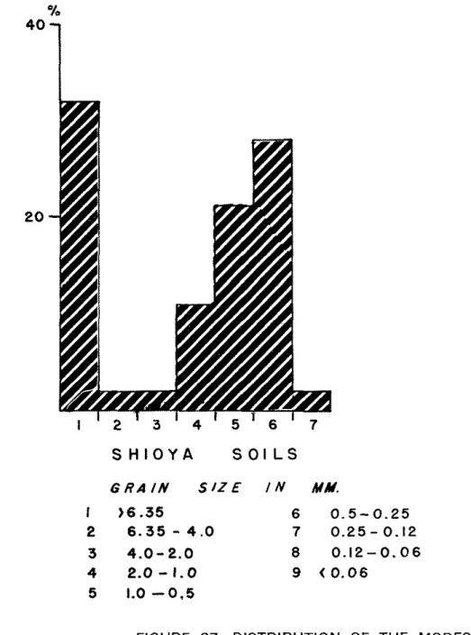
Stony and v e r y ' s t o n y complex 54 Shioya s e r i e s. . .
54Arno A t o l l s e r i e s
. . .
56Jemo' s e r i e s
. . .
58Miscellaneous s o i l s
. . .
60Summary of chemical i n f o r m a t i o n
. . .
60Shioya s o i l p r o f i l e s
. . .
:. . . :
6 1 Arno.Atol1 s o i l p r o f i l e s. . .
6 1 Jemo s o i l p r o f i l e s. . .
:. ! . . .
62Hydrogen i o n c o n c e n t r a t i o n s i n t h e t h r e e t y p e s of p r o f i l e s
. . . ..
: . 64'
. .
. . . ....
SUMMARY AND CONCLUSI~NS. . . . .
65. . . . REFERENCES
. . . .
. 67. . APPENDIX I
.
Data for' b e i c h sand samples c o l l e c t e d by C h a r l e s.
G.
Johnson and F 'Stearns ~ a c ~ e i l. . .
73. .
1 Samples c o l l e c t e d by C h a r l e s.
G Johnson. . .
732
.
Samples c o l l e c t e d by F S t e a r n s Macffeil. . .
76APPENDIX I1
.
' ~ i e l d d e s c r i p t i o n s o f s o i l p r o f i l e s : o r sedimentary s e c t i o n s. . .
101I n d e x t o s o i l p r o f i l e s
. . .
145. . . .
. . .
APPENDIX III: Synonymy of p l a c e names 147 I l l u s t r a t i o n s Following page ..
F i g u r e 1.
Map of t h e n o r t h e r n M a r s h a l l I s l a n d s. . . .
F r o n t i s p i e c e 2.
Diagrammatic c r o s s s e c t i o n s of i s l e t s on windward and leeward r e e f s of a t o l l s. . .
63
.
Diagrams o f t y p i c a l windward i s l e t s. . .
22Following page
. . .
F i g u r e 4 . Diagrams of t y p i c a l leeward i s l e t s 5. Taongi (Pokak) A t o l l showing g r a i n s i z e
d i s t r i b u t i o n of beach sands
. . .
6 . B i k a r A t o l l
. . .
7 . Ailuk A t o l l
. . . . . .
8. K w a j a l e i n A t o l l
9 . Lae A t o l l
. . .
10. L i k i e p A t o l l . .
. . . . . .
11. Taka A t o l l
. . .
12. Ujae A t o l l
. . .
13. Ujelang A t o l l
. . .
14. U t i r i k A t o l l
15. W o t h o A t o l l
. . .
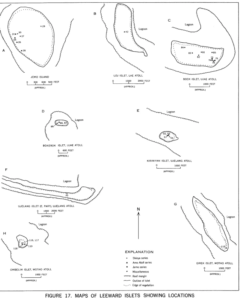
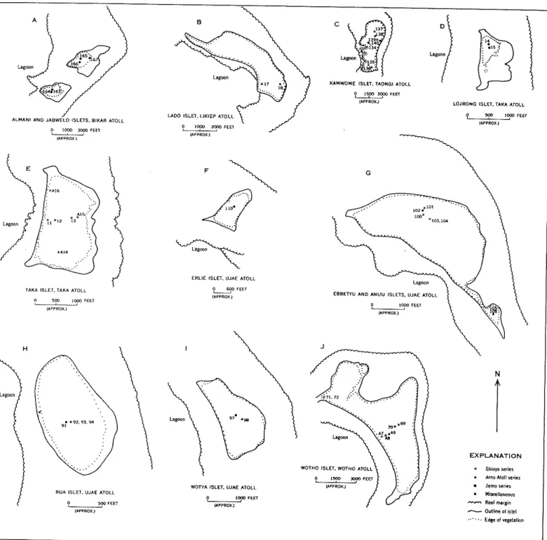
16. Maps o f windward i s l e t s showing l o c a t i o n s From which s o i l samples were c o l l e c t e d
. . .
17. Maps of leeward i s l e t s showing l o c a t i o n s from which
. . .
s o i l samples were c o i l e c t e d
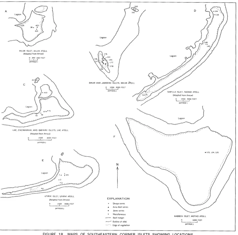
18. Maps of s o u t h e a s t e r n c o r n e r i s l e t s showing l o c a t i o n s from which s o i l samples were taken
. . .
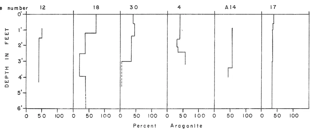
19. Grain s i z e d i s t r i b u t i o n and r e l a t i v e amounts of c a l c i t e and a r a g o n i t e i n s o i l s on U t i r i k , Jemo,
L i k i e p , and Taka A t o l l s
. . .
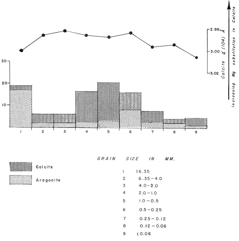
20. Average m i n e r a l o g i c composition of s o i l p r o f i l e s
. . .
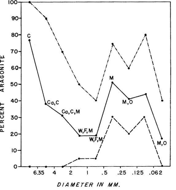
21. Major c o n s t t t u e n t s and a r a g o n i t e i n t h e v a r i o u s
. . .
g r a i n . s i z e s of s o i l s
22. A r a g o n i t e c o n t e n t of t h e s o i l p r o f i l e s
. . .
23. Frequency of primary and secondary modes i n t h e s i z e d i s t r i b u t i o n of a l l beach sands examined
from Ghe n o r t h e r n M a r s h a l l I s l a n d s
. . .
24. S i z e d i s t r i b u t i o n and compositioh of t h e Shioya
. . .
s e r 5 e s s o i l s
25. S i z e d i . s t r i b u t . i o n and composition of t h e Arno A t o l l s e r i e s : s o i l s
. . .
26. S i z e d i s t r i b u t i o n and composition of u n c l a s s i f i e d
. . .
s o i l s
27. D i s t r i b u t i o n of t h e modes i n Shioya and Arno A t o l l
. . .
s o i l s . .
28. Comparison o f g r a i n s i z e d i s t r i b u t i o n o f beach sands . .
a n d s o i l s . . . : . : 29. Schematic :diagram o f ' a h y p o t h e t i c a l ' a t b l l showing
. . .
. .
d i s t r i , b u t i o n of s o i l t y p e s. . .
30. R e l a t i o n of . a c i d i t y t o o r g a n i c matte?
'in
rnibcellaneous.
s o i l s with. h i g h o r g a n i c m a t t e r c o n t e n t. . .
P l a t e 1. A e r i a l views of Lae and Ailuk
. . .
22-
2. I s l e t s on r e e f s of A i l u k and Taka A t o l l s. . .
,II ,
3. C o r a l s growing i n lagoon
. . .
4 . Surge channel through a l g a l r i d g e , windward r e e f
. . .
1 ,5 . Windward r e e f f e a t u r e s
. . .
116 . D e t a i l s of r e e f f l a t s
. . .
I,P l a t e 7.
-
0 .Following page
. . .
Outer margin of l e e w a r a r e e f 22.
Windward reef f l a t
. . .
11Rubble t r a c t s on reef f l a t s
. . .
IICrescent-shaped gravel bar
. . .
IFPost-Pleistocene eroded reef platforms
. . .
)IExposures of post-Pleistocene reef platforms
. . . .
I IBoulder beach and exposed post-Pleistocene rock
platform, with s t a c k and p e r c h e d b o u l d e r
. . .
IISurfaces of erosion ramps
. . .
(ISolution b a s i n s on erosion ramps
. . .
IIS p a l l i n g off of erosion ramp s u r f a c e s
. . .
I IGravel and boulder beaches
. . .
IISand and gravel beaches on lagoon s i d e of i s l e t s
. .
I ID e t a i l s of abraded beachrock
. . .
IID e t a i l s , of beachrock
. . .
I IBeach r i d g e s of pebbles ond cobbles
. . .
11D e t a i l s of boulder and cobble r i d g e s and o t h e r
coarse d e p o s i t s
. . .
IIMiscellaneous d e p o s i t s
. . .
30Types of v e g e t a t i o n on islets
. . .
. . 8 1Pisonia f o r e s t and f o r e s t s o i l
. . .
t t--
Shore and sand f l a t vegetation. . .
11Pioneer v e g e t a t i o n
. . .
IIBeach sand, appearance of m a t e r i a l i n t h e 2-4 mm
grad.e
. . .
42Beach sand, appearance of m a t e r i a l i n t h e 1-2. mm
grade
....:...
.,. . .
11Beach sand, appearance of m a t e r i a l s i n t h e 0.5-1,
0.25-0.5, and 0.12-0.25 -nun grades
. . .
IICalcaiiina sp. showing v a r i o u s s t a g e s o f abrasion
i n beach. sand
. . .
IIE f f e c t s of typhoon on U t i r i k i s l e t
. . . : . . .
64F o r a m i n i f e r a i n s o i l s from t h e Marshall I s l a n d s
. . .
II. .
Tables Table
-
1. Foraminifera i n various types of t e r r e s t r i a l sediments on a t o l l s i n t h e northern Marshall. . .
.
. I s l a n d s 2 72. Q u a n t i t a t i v e r e l a t i o n s h i i s of t h e four major
c o n s t i t u e n t s of r e e f s
. . .
2 93. P a r t i a l chemical composition of some sediment-
forrring red a l g a e a s percent of dry weight
,
,. .
30-
vii-
Following page Table 4.
-
Size distribution (percent by weight), median grain diameter, sorting coefficient, and skewness of beach sands from islets on various atolls inthe northern Marshall Islands
. . .
42Grain-size distribution (percent by weight), and
pH of soils in the northern Marsl~all Islands
. . . .
I ICoefficient of sorting of Marshall Islands beach sands in relation to major constituents and
skewness of distribution
. . .
1 ,Page Distribution of modal grade size of calcareous
material in soil profiles as percentage of
total samples sieved
. . .
50Chemical composition (in percent) of calcareous reef and lagoon constituents, and of composite
sediment samples (from Emery, et al., 1954)
. . .
51Following page Major chemical constituents (in percent) and pH of
northern Marshall Islands soils
. . .
64Occurrence of minor elements (in percent) in Jemo
. . .
seriessoils 11
Spectrographic determinations of minor elements in
the Jemo series soils
. . .
11Ranges in amounts of minor elements in samples of soil materials from the Jemo soil series on Bikar, Jemo, Ujae, Kwajalein, and Wotho Atolls,
northern Marshall Islands
. . .
11Organic carbon (percent) and pH of certain highly
organicsoils
. . .
1 1Major chemical constituents (average percentages) and pH of samples from Arno Atoll, Shioya, and Jemo series soils collected from atolls in the northern
Marshall Islands
. . .
IIAn i n v e s t i g a t i o n was made of s u r f a c e geology, i s l e t forr;,ution, sediinentation, and physical and chemical n a t u r e of loose sediments 0::
a t o l l s of t h e northern Mzrshall I s l a n d s .
I s l e t s i n t h e i r present fonn a r e of t h r e e types, based n t 0i.1g.i~
and p o s i t i o n : ( 1 ) formed by p a r t i a l removal by planation of p r c c s i s ? : l r ~ r e e f platfom., leaving remnants around which sediments a.ccuniulate:
( 2 ) formed by accumulation and s t a b i l i z a t i o n of d e t z i t a l deposi-ca oz r e e l f l a t s , and
( 3 )
fonned by accumulation of d e t r i t a l d e p o s i t s l\jca:llx w i t h i n t'ne lagoon, e s p e c i c l l y j u s t i n s i d e channel mouths. Physioi;r;upnic f e a t u r e s of i s l e t s - - e r o s i o n ramps, sand lobes, scnd horns, sand a.pmns,.t i d a l a.nd storm becches, rocls shores, beachrock, marginal r i d z e s , J,ur~es, i n t e r i o r f l a t s and depressions, p a r a l l e l r i d g e s , and blowdo?m mou;!.dr; dre:
described, and t h e i r p r i n c i p a l organic compon5nts l i s t e d .
Mechan.ica1 analyses vere made o f samples of beach sands cnd s o i l s S i z e c l a s s e s were c o r r e l a t e d t o some e x t e n t with faunal compositior. of t h e m a t e r i a l s , snmll For'minifera accounting f o r a l c r g e p a r t of t h e 2-1 mm and 1-0.5 nun s i z e s . Larger f r a c t i o n s 'qere made up of whole o r broken c o r a l s , l a r g e fragments o l a l g a e , l a r g e s h e l l s . F r a c t i o n s
smaller than 0.25 nun a r e mostly of broken u n i d e n t i f i a b l e fragments.
The frequency of t h e modes ( o r maximum grades) i n t h e s i z e d i p . t r i b u t i o n i n t h e beach sands i s a s follows: 2 t o 1 m (-10
+ i8
mesh) 21 percent, 1-0.5 mm (-18+ 35
mesh),48
percent, and 0.5 -0.25 ;:TI(-35
+ 60 mesh), 17 percent. I n none of t h e ~ a n d s i s t h e r e a ))ri:,iar:/ruode i n t h e
+
0.125 mm,+
0.062 m i l , o r l e s s t h a n 0.062 mm fr:,.ztions.Determination of mineral coinposition of t h e sediments by :;-:cry d i f f r a c t i o n shows a c o r r e l a t i o n of c a 1 c i t e : a r a g o n i t e r a t i o s w l t h o r i g i n a l b i o l o g i c a l composition r a t h e r than with degree of we;ltheririr.
Considerable magnesium i s present i n t h e c a l c i t e , especially i n ocdi- n ~ e n t s l a r g e l y made up of algae, i n t h e middle s i z e grades of t h e
sediments.
Median g r a i n diameter, s o r t i n g c o e f f i c i e n t , and slrewness were calcula.ted l o r t h e samples. Size d i s t r i b u t i o n s , i l l u s t r a t e d by h i s t u - g r a m , show t h a t t h e beaches a r e , i n general, sirnilar Pro:n i s l e t t~
i s l e t , even though t h e i n d i v i d u a l samples :rmi n beach niay vary.
Beach m a t e r i a l s do not becolile iiiuch smaller thun 0.25 rrm era;in
diameter, o r e l s e t h e snlaller n ~ z t t e r i a l i s l o s t by winnowing by lizves o.nd c u r r e n t s . Slsevness i n i?~ost sands i s p o s i t i v e , i n d i c n t i n g tidmix- t u r e of coarse nmterie.1 m d lacls o r f'ines.
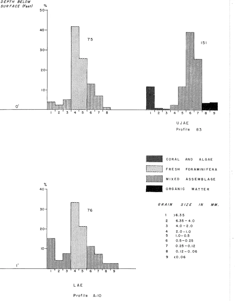
The s o i l s resemble beach r o z t e r i a l s i n t h e i r mechanicai malysc;.
but t h e t e x t u r e range i s enormously :rider and t!le range i n s o r t i n g is a l s o wider. Tine s o i l s a r e i r r e g u l a r l y s t r a t i f i e d , common3j ww.lt11 ~ e a 1 ; p r o f i l e development, but with s t r a t c mostly representint3 s t a g e & o r events i n d e p o s i t i o n . Most s o i l s can be assigned t o t h r e e prevl:uel.y described s e r i e s , t h e Shioyo., Arno A t o l l , and Jenlo, S~ut, cert,riu h.i&1y o r g a ~ i . c s o i l s could not be d e f i n i t e l y assigned t o s e r i e s . Th-sl-;
s e r i e s d i f f e r chemically i n t h e mounts of organic matter i n t h e A horizons and t h e presence o r absence or' a phosphatic B horizon. A, horizons and B horizons a r e found only i n t h e Jemo s e r i e s s o i l s , usu- a l l y c o r r e l a t e d with t h e presence of Pisonia f o r e s t vegetation.
Chemical analyses sho~r t h a t v e r t i c a l trends i n t h e amounts of c e r t a i n elenents i n t h e d i f f e r e n t l a y e r s are.dj.scernible: magnesium increases downward; c a l c i u n i s lowest i n l a y e r 1 because of t h e higher organic content, and t h i s i s e s p e c i a l l y obvious i n tile Jemo s e r i e s . Of t h e minor elements, iron, cobalt, nickel, rolybdenuol, and zinc a r e much higher i n t h e raw humus l a y e r of t h e Jemo s e r i e s p r o f i l e s , suggesting accumulation of t h e s e elements by t h e Pisonia t r e e i n i t s t i s s u e s . Most of t h e m e t a l l i c c o n s t i t u e n t s , except calcium and rmginesium, a r e present i n extremely small amounts. Serious d e f i c i e n c i e s i n most
mineral n u t r i e n t s of p l a n t s , except calcium, ma~;nesiuri, phosphorus, and possibly potassium, would be expected. These might he i n t e n s i f i e d , i n
some cases, by t h e s t r o n s l y calcareous environment.
pH values a r e high i n a l l l a y e r s except t h e raw humus l a y e r of t h e Jemo s o i l s where t h e pH ranges between 4 and 6 .
INTRODUCTION by F. R. Fosberg
I n s p i t e of t h e g r e a t &mount o f ' a t t e n t i o n t h a t has been p a i d t o t h e geology of c o r a l a t o l l s , r e l a t i v e l y l i t t l e d e t a i l e d information i s a v a i l a b l e on t h e chemical and p h y s i c a l p r o p e r t i e s of t h e sediments 'irhich rmlce up a t o l l i s l e t s , on t h e i r weathering, t h e i r o r i g i n , t h e i r
s t r a t i g r a p h y , o r t h e c o n d i t i o n s under which they Irere k i d dorm. The a v a i l a b i l i t y of a l a r g e s e r i e s of s m p 3 . e ~ r e p r e s e n t i n g s e c t i o n s dotin t o t h e m t e r t a b l e o r t o bedrock i n t h e northern Marshall I s l a n d s , and of a considerable body of chemical and mechanical <analyses of t h e s e s m - p l e s has made it p o s s i b l e t o remedy t h i s d e f i c i e n c y t o some e x t e n t . The study of t h i s m a t e r i a l has yielded a p i c t u r e of t h e general n a t u r e of t h e sediments, but has a l s o brought out c e r t a i n problems which only f u r t h e r research w i l l s o l v e .
F i e l d woric
The m a t e r i a l considered here ?ras c o l l e c t e d on a reconnaissance survey of t h e m i l i t a r y geography of a nuniber of t h e a t o l l s i n t h e northern p a r t of t h e iflarshall I s l e n d s , and t h i s paper i s a by-product of t h a t i n v e s t i g a t i o n . T h i s survey was c a r r i e d out by
a
f i e l d p a r t y of t h e U.S. Geological Survey voricine; f o r t h e Office of t h e Engineer, Headquarters, U.S. Army Forces, F a r E a s t , during 1951 and 1952. Most of t h e s o i l samples were c o l l e c t e d by F. R . Fosberg; some were c o l - l e c t e d by Ted Arnow, hydrologist of t h e p a r t y , cluring t h e digging of w e l l s . Beach sand samples !rere gathered by F. S t e a r n s MncNeil and Charles G . Johnson, g e o l o g i s t s . The sampling i s admittedly inadequate because of t h e broad n a t u r e of t h e a s s i g m e n t and t h e f a c t t h a t only minutes, hours, o r a t t h e most, p a r t s of a few dzys, v e r e a v a i l a b l e f o r riork on s o i l s of any given i s l e t .The circumstances of t h e survey (Fosberg,
1955)
rrere such t h a t it rras p o s s i b l e t o o b t a i n a scc.ttering of m a t e r i a l from over a v i d e a r e a b u t impossible t o study any s i n g l e a t o l l o r i s l e t i n d e t a i l . Further- more, l a c k of any previous s o i l s 'irorls i n t h i s a r e a rnade t h e sampling,e s p e c i s l l y i n t h e e a r l i e r a t o l l s v i s i t e d , a rmdom procedure r a t h e r t h a n one designed t o b r i n g o u t any s p e c i f i c type of' information o r t o i n v e s t i s a t e p a r t i c u l a r probleriis.
Laboratory work
-
After t h e samples c o l l e c t e d had been brought i n , described, and t h e s o i l s assigned t o p r e v i o u s l y known o r t o neT? a t o l l s o i l s e r i e s , it Iras f e l t t h a t f o r t h e purposes 02 t h e m i l i t a r y geography r e p o r t (Fos- berg and o t h e r s ,
1956),
more should be lrnom about t h e p h y s i c a l proper- t i e s of t h e sands and s o i l s ilnd tha.t some chemical s t u d i e s should be made i n o r d e r t o understand t h e severe a g r i c u l t u r a l l i m i t a t i o n s of t h e s e s o i l s . A s e l e c t i o n of s m p l e s was made t h a t it ves hoped vould prove r e p r e s e n t a t i v e of t h e s o i l s i n t h e a r e a s t u d i e d . It rms unfor- t u n a t e , but unavoidable,that t h i s s e l e c t i o n had t o be made before t h e problems regarding t h e s e s o i l s v e r e c l e a r l y formulated. Because of t h e unusual i n t e r e s t of t h e phosphatic m a t e r i a l s a more completer e p r e s e n t a t i o n of them was eaalyzed t h a n of t h e o t h e r m a t e r i a l s . The lower l a y e r s of a l l t h e types of s o i l p r o f i l e s a r e poorly represented i n t h e analyses. Organic carbon i n l e s s humic s o i l s was not determined.
Future work, on more c r i t i c a l l y s e l e c t e d complete p r o f i l e s down t o zround water i n a l l t h e s e r i e s , i s much .to be d e s i r e d .
Previous s t u d i e s
S t u d i e s have been made on v a r i o u s a t o l l s a s p a r t of t h e Coral A t o l l Program of t h e P a c i f i c Science Board (Stone,
19519, 1953>
Cloud, 1952; Hathevay,1953,
1957; Fosberg and Sachet, 1953; Newell, 1954b,1956;
Sachet,1955j
McKee,1956, 1958;
Fosberg, 1957b; Catala,1957,
McKee and o t h e r s ,
1959;
Tracey and o t h e r s , 1961), on B i k i n i and nearby a t o l l s by t h e Crossroads Operation Survey and subsequent surveys (Emery, Tracey, and Ladd,1954),
and on U l i t h i A t o l l by [email protected] and Brookhart(1955). These, a s well a s t h e investi@;ations reported here ( a l s o reported i n Fosberg,
1954,
19573, Fosberg and o t h e r s , 1956), make it p o s s i b l e t o know what t o expect i n t h e way of s o i l and sediment types, a s w e l l a s a r e a l and s t r a t i g r a p h i c arrangements of sediments, and t o define a t l e a s t sorlie of the-problems which should be i n v e s t i g a t e d . Cer- t a i n e a r l i e r l i t e r a t u r e , e s p e c i a l l y t h e p u b l i c a t i o n s r e s u l t i n g from t h e expeditions t h a t made t h e boring on Funafuti i n1896
( ~ o l l a s and o t h e r s , 1904), those of Wentworth and Ladd (1931) on t h e Central P a c i f i c A t o l l s , and t h o s e of Kuenen on East Indian A t o l l s(1933,
1950) a l s o c o n t r i b u t e important information. The paper by Ladd, Tracey, Wells, and Emery (1950) i s of s p e c i a l significance i n understanding t h e o r i g i n of t h e seZiments with which we a r e d e a 1 i n g . yLand a r e a s
The Marshall I s l a r ~ d s coniprise
31
a t o l l s and s i n g l e low i s l a n d s s c a t t e r e d over an a r e a nearly 700 m i l e s from n o r t h t o south and e.bout t h e same d i s t a n c e from west t o e a s t , between4'34'
N . and 1k043' N. and 160°48' E . and 172°10' E . They form two very i r r e g u l a r , roughlyp a r a l l e l chains t h a t t r e n d northwest-southeast. The western chain i s c a l l e d Ralik, t h e e a s t e r n Hadalc. This arrangement, however, i s d i f f ' i - c u l t t o d i s c e r n on a map. Before reading f u r t h e r , t h e reader i s urged t o consult t h e s e c t i o n "Synonomy of p l a c e nanles" st t h e end of t h e r e p o r t .
Since t h i s paper ~ e a c h e d i t s f i n a l form, a number of p e r t i n e n t and important papers have appeared, such a s Blumenstock, ed., 1961, Guilcher e t a l . , 1965, Hoskin,
1963,
McKee,1959,
Newell, 1960, Russell, 1962, 1963 and Stoddart, 1960, 1962a, 1962b, 1963, 1964,1965.
None of them, however, appear t o n e c e s s i t a t e s e r i o u s raodification of i n t e r p r e t a t i o n s presented here, though not a l l t h e s e a u t h o r s would agree completely with our i n t e r p r e t a t i o n s .The present paper i s concerned only with those 21 a t o l l s o r i s l a n d s l y i n g north of 8'30' ( f i g l ) , h e r e a f t e r -~.@ferred t o ~ t s t h e northern Marshall I s l a n d s . These a r e , from north t o south and west t 3
e a s t , Taongi (Pokak), Bilcar, Eniwetok, Bikini, Ailinginae, Rongelap, Rongerik, Taka, Utirilc, Ujelang, Wotho, Likiep, Jemo, Ailuk, Mejit, Ujae, Lae, Kwajalein, Wotje, Erilrub, and Maloelap, 2 1 i n a l l . hkloelap could equally well be included i n t h e Southern Marshalls. Observations were a c t u a l l y made and m a t e r i a l c o l l e c t e d f o r study on Taongi (Pokak), Bikar, Taka, U t i r i k , Ujelang, Wotho, Likiep, Jemo, Ailuk, Ujae, Lae, and Kwajalein. I n addition, use has been made of c e r t a i n observations, analyses, and c o l l e c t i o n s made by t h e g e o l o g i s t s of the Crossroads Sur- vey i n Eniwetok, Bikini, and nearby a t o l l s i n 1946.
The land on these a t o l l s i s nowhere much above sea-level, averaging between 4 and LO f e e t above mean low t i d e . The highest elevations a r e beach ridges, p i l e d up by storms, and sand dunes. The highest recorded elevation i n t h e group i s a sand h i l l o r beach ridge on Likiep Atoll, variously s a i d t o be 25 t o
37
f e e t high. These higher f e a t u r e s a r e a l l composed of loose sediments. The consolidated p l a t - fornls on which much or t h i s loose m a t e r i a l r e s t s a r e mostly between mean low t i d e level. and about6
f e e t above, with a very few humps extending up a few f e e t more (only seen on Bwok\'rla ( ~ o k l a o r South) I s l e t , Taongi ( ~ o k a k ) toll).
The r e l a t i o n s h i p of the individual i s l e t s of an a t o l l t o t h e underlying reef i s shown diagrammatically i n f i g u r e 2.Climate
The climate of the northern Marshall Islands i s t r o p i c a l , with very l i t t l e v a r i a t i o n i n temperature. The extreme v a r i a t i o n i s from about 68O F t o 97' F, but most of t h e time t h e mange i s from
76"
F t o87'
F, with a mean of about 82' F. The sunlight i s intense cwd t h e sky usually characterized by considerable s c a t t e r e d cumulus cloudiness.Really cloudy days a r e r a r e but do occur. The i s l a n d s a l l l i e i n t h e trade-wind b e l t , with prevailing winds from t h e e a s t t o northeast, strongest i n t h e winter and spring months. Calms, weak, variable winds o r southeasterly winds may occur from June t o September. S t o r m s a r e l i k e l y t o come from t h e soutfl. Typhoons a r e r a r e but sometimes extremely severe and d e s t r u c t i v e . These, also, usually t r a v e l i n a general n o r t h e r l y d i r e c t i o n and r o t a t e counterclockwise. Both typhoons and t r e d e winds a r e of g r e a t importance i n determining t h e topography of t h e i s l e t s and t h e nature and d i s t r i b u t i o n of sediments.
Available moisture i s of primary importance i n t h e veathering and leachine; of sediments, s o i l formation, and i n determining t h e nature and luxuriance of vegetation. The i s l a n d s a r e r e l a t i v e l y dry, compared t o t h e southern Marshall Islands and t h e Caroline A t o l l s . The r a i n f a l l decreases r a p i d l y t o t h e northward, with a t o t a l range from a recorded extreme of 149 inches t o
25
inches o r l e s s , possibly almost no r a i n i n very dry y e a r s i n t h e northernmost of t h e a t o l l s . The annual averages range from an estimated 40 inches i n t h e north t o a recorded 106 inches i n t h e south. The r a i n f a l l i s strongly seasonal, December t o April being t h e d r i e s t months, June t o November t h e w e t t e s t . The r a i n f a l l i nany one a t o l l v a r i e s treli~endously from year t o year, even i n corres- I ponding months. The extreme annunl f i g u r e s recorded f o r Ujelang a r e a
low of 52 and a high of 116 inches. Comparable f i g u r e s f o r Kwajalein
a r e 8 2 and 149 inches; f o r Eniaretok,
24
and 73 inches. It w i l l be noted1 i
th8.t none of these figures i n d i c a t e a dry climate a s understood i n con- 1 t i n e n t a l regions, but with t h e s p e c i a l s o i l conditions on a t o l l s , t h e
lower f i g u r e s a r e c o r r e l a t e d with 8.n aspect of r e l a t i v e a r i d i t y i n t h e
I
landscape. The r e l a t i v e humidity i s o r d i n a r i l y f a i r l y high> a s might be ! expected from t h e proximity of t h e ocean, t h e lowest monthly mean
r e c o r d e d b e i n g 66 percent f o r noon readings on'Eniwetok. I n t h e more I n o r t h e r l y a t o l l s it doubtless reaches a lower f i g u r e than t h i s occasion-
a l l y .
Tides
- ~
T i d a l datn f o r c o r a l a.tolls a r e generally u n s a t i s f a c t o r y , a s t h e r e
I
a r e few s t a t i o n s and t h e lagoons with openings of d i f f e r e n t s i z e s i n t r o - duce complications. I n t h e U.S. Coast and Geodetic Survey t i d e t a b l e s f o r 1966 information f o r t h e Marshall I s l a n d s is calculated from predic-
t i o n s made f o r Kwajalein. There i s no i n d i c a t i o n a s t o whether t h e
I
I
i
observational d a t a on which these p r e d i c t i o n s a r e based were c o l l e c t e d
i n t h e lagoon o r on t h e windward o r leeward seeb?rard c o a s t s . Because of
~
t h e p e c u l i a r geographic r e l a t i o n s introduced by t h e difference i n s i z e and i n number of openings i n t o a lagoon, t h e t i d a l behavior, and
e s p e c i a l l y t h e l a g i n t i d a l events i n s i d e compared with outside of t h e lagoon, t r i l l be highly ~ a r i a b l e from a t o l l t o a t o l l . An extreme example m8.y be c i t e d , t h a t of Taongi (Pokak), where t h e opening i s so small t h a t
t h e t i d e l e v e l i n s i d e t h e lagoon never rails s i g n i f i c a n t l y below t h e I ! l e v e l of t h e r e e f , though outside t h e spring t i d e range i s
4.7
f e e t . I Keeping i n mind these reservations, d a t a from t h e t a b l e s f o r 1966 show ! t h a t t h e mean t i d e ranges, presumably outside t h e lagoons, i n t h e1
northern Marshall Islands a r e f r o a 2i7 t o 3.7 f e e t , t h e spring ranges,i
3.9 t o
5 . 1
f e e t , t h e maximum d i f f e r e n c e i n one day, 6.6 f e e t ; t h e mini-mum difference between high nnd low, 0 . 0 f o o t , t h e minimum difference i n
i
one day, 0.0 f o o t . These f i g x r e s are, o f course, a l s o subject t o v a r i a - I ! t i o n due t o weather conditions both l o c a l and general, o r even elsewhere I i n t h e P a c i f i c ; It i s probable t h a t c&reful s t u d i e s would show t h a t ! s i ~ m i f i c a n t nverage f i g u r e s f o r any gi'ven l o c a l i t y could be derived from i t h e v e r t i c a l d i s t r i b u t i o n of c e r t a i n s e s s i l e organisms i n t h e intertide.1
I
Izone, r e f l e c t i n g t h e i r capacity t o endure exposure t o a i r . Such s t u d i e s
a r e not, t o t h e b e s t of my knoviledge, a v a i l a b l e y e t i n sufr'icient d e t a i l I t o be used.
L A G O O N Reef rock o ' ~ ! ( ~ r ~ S E A
1 5 - -
---
-" O M v , O W , ,
.
. .. .... , .,,<&"'
-..-..:eo *",as<* r o c .
I,
Leeward I s l e t ( w e s t )
Leeward : s l a t ( r o u f h l
2. Diagrammatic cross sections of islets on windward and leeward reefs of atolls showing positions of reef rock, unconsolidated materials, beach rock, rock platforms, and erosion ramps.
PART
I: GEOLOGY by F. R. Fosbergology of these a t o l l s has been described i n several pub- Ladd and Hoff'meister, 1940; Nugent
1946;
Emery, Tracey and Ladd,1954;
Fosberg and others,1956,
p. 76-132; and Fosberg,1957
a ) . A summary of the geology follows.Physiographically an a t o l l i s the upper calcareous p a r t of a broadly conical or irregularly pyramidal mountain mass r i s i n g from the floor t o the surface of the ocean. Only the top of t h i s i s usually considered, geographically, and of t h i s only the p a r t which breaks the surface of the sea need be discussed here. Thus restricted, the northern Marshall Islands are a s e r i e s of narrow platforms or reefs, usually irregularly ring-shaped o r polygonal, conrmonly
enclosing a shallow body of ocean water called a lagoon (pl. 1.4). Of these platforms by f a r the largest areas l i e a t o r just above or below t i d e level and are called the reef f l a t . The outer edge of
t h i s either f a l l s off abruptly, as on leeward sides, o r i s elevated i n the form of a low ridge, as on windward sides. The inner margins, where not occupied by i s l e t s , shelve off into the lagoon. The surface of the reef f l a t may be r e l a t i v e l y smooth or locally quite rough or strewn with great boulders. Scattered along these platforms are
areas t h a t r i s e above high-tide level, called i s l e t s (perhaps
a
b e t t e r term i s the Polynesian word m n , but even t h i s i s not completely devoid of ambiguity) (pls. 1, 2). These i s l e t s , though forming only an in- finitesimal p a r t of the area and bulk of a t o l l s , are i n many respects the most interesting one, and t h a t with which t h i s reporti s
principally concerned.The e n t i r e structure of an a t o l l , except the deeply submerged p a r t of the found&ion, i s made up of organic limestone sediments, e i t h e r loose or variously consolidated. Deep borings on Bikini and Eniwetok have given much information on the nature of the sediments making up the p a r t below sea l e v e l (Emery, Trace
,
and Ladd, 1954;Ladd and others, 1953; Ladd and Schlanger, 1960.
y
These are mostly unconsolidated material, and extend downward t o more than 4,000 f e e t below sea level. Some layers are consolidated o r p a r t l y so. Most of the material resembles t h a t deposited i n the lagoon today. A few traces of carbonaceous material, with land plant pollen and f o s s i l land and fresh-water shells, suggest t h a t some of these sediments were once t e r r e s t r i a l and supported vegetation.Origin of the reefs
Before considering the morphology and structure of the i s l e t s , themselves, it w i l l be necessary t o give brief attention t o the origin and nature of the reefs and the materials of which they are coruposed. This i s , i n certain aspects, a highly controversial sub- ject, and f o r more adequate treatment of it reference may be made t o the publications c i t e d above. The limestone i s made up of the skele- tons of lime-secreting animals and plants, mainly corals. Foraminifera,
and those algae which possess hard skeletons (see p.
56-74).
These animals and plants add t o the r o c w structure on which they grow i n two different ways. Some of them are firmly attached and cemented onto the rock, adding by the growth of t h e i r skeletons t o the material of the rock i t s e l f , e i t h e r i n the form of crusts or as outgrowths. Storm waves may break these off. Others are e i t h e r free or loosely attached, becoming f r e e when they die. The loose material so formed, as well as t h a t resulting from breakage, accumulates on the reefs, on the i s l e t s , i n the lagoons, and on the submarine outer slopes of the a t o l l s . That on the i s l e t s comprises the sediments t h a t are the subject of t h i s report.
The firniiy attached organisms a r e of many different shapes and grow together very abundantly i n the warm seas of the tropics.
Attaching themselves t o each other, a s well as t o the rocks, t h e i r skeletons form a r i g i d latticework of limestone, which may be f i l l e d i n e i t h e r by growth or by deposit of loose sediments i n the i n t e r - stices. Most of the corals (pl.
3)
a r e branched; often they are miniature t r e e l i k e structures t h a t are rather f r a g i l e and e a s i l yshattered o r torn loose by storm waves (pl.
3A, B).
Some of those exposed t o direct wave action have more compact growth forms and are more resistant. By themselves, however, most oT the corals wouldnot bs able t o make the stable structure known as coral reefs. !Ihe function of cementing and binding these corals together into a mas- sive rock i s performed by certain of the calcareous algae ( ~ l a n t s ) ( ~ 1 s .
4, 5 )
and by certain colonial hydrozoans (Millepora) (animals) related t o corals, which grow with no fixed or d e f i n m o r m s but which make a shapeless hard crust over the surfaces of the otheranimals, smothering them, f i l l i n g i n the holes and spaces between them, thus presenting a smoother and more r e s i s t a n t surface t o the force of the waves. These binding organisms, especially the plants, thrive best i n the roughest, most thoroughly aerated water. For t h i s reason the firmest structures of the a t o l l s are on the windward sides where the swells break ccntinuously. Growth of reef-building organ-
isms, generally, i s f a s t e r on the outer edges of the reefs where waves break, thus building up these portions more rapidly than the more protected parts ( p l .
5A,
C ) . Usually the most perfect and mosti n t r i c a t e l y branched coral skeletons may be found i n quiet places, such as lagoons (pl.
3),
or i n water below the active turbulence zone on the outer slopes, where they are not smashed by heavy waves. How- ever, the greatest amount of limy material i s added on the outer edges of the reefs. This area i s also the source of much of the f r w e n t a r y material which forms the sediments t h a t f i l l large parts of the reef structure. It has been shown by the studies a t Bikini (Ladd and others, 1950) t h a t loose material detached from the reefs, especially on the windward sides, i s c a r r i e d b y currents, waves and winds w d deposited i n various other parts of the a t o l l structure t o form the sediments of which the a t o l l i s largely composed. Any hole i n the latticework, any protected pool o r cavity, as well as the lagoon i t s e l f , tends t o be f i l l e d i n by t h i s loose material. This debrismay become cemented e i t h e r by grovrth of such Sinding organisms as those mentioned above or by deposition of lime from the sea water, thus adding t o the strength of the reef structure, or it may remain indefinitely as unconsolidated sediments protected from wave action by the surrounding r i g i d framework of the reefs.
It might well be supposed t h a t these masses of limestone had grown up d i r e c t l y from t h e i r volcanic foundations u n t i l they reached the surface of the ocean. This cannot be true, however, because none of the important reef-building organisms can thrive i n water too deep t o permit a significant amount of l i g h t t o reach them. The actual l i m i t s of growth of these organisms vary greatly, but there i s certainly l i t t l e material added below a depth of 300 feet, and the hiportant addition i s araove 150 f e e t . These f a c t s have been known f o r a. long time and recent investigation has tended t o confirm and amplify previous knowledge of these limitations. merefore, it i s clear t h a t other principles must be involved i n the presence of enormous masses of limestone below the l i m i t s of effective penetra- t i o n of l i g h t into sea water. These principles have been the center of violent s c i e n t i f i c controversy f o r more than a hundred years, and only the investigations of the l a s t 20 years have brought matters t o a point where a brief, reasonably convincing generalization can be made of the mode of origin of coral a t o l l s .
There now seems l i t t l e doubt t h a t all reef growLh took place i n shallow water and t h a t the volcanic foundations of the a t o l l s have subsided with relation t o sea level, the r e l a t i v e change i n ele- vation being slow enough t o allow upward growbh t o keep pace with the subsidence. In t h i s way the zone of active growth would have remained within the levels where l i g h t was sufficient. Whether t h i s relative change was due t o actuaL subsidence of the volcanic islands or t o worldwide changes i n sea level i s not certain, but it i s probable t h a t both took place. During the g l a c i a l periods, especially, there are known t o have been considerable s h i f t s of sea level and unques- tionably these have had a profound e f f e c t on the present form of coral islands. It i s believed, f o r example, t h a t within the l a s t few
thousand years there has been a f a l l of approximately
6
f e e t (or 11 f e e t according t o some authorities, especially Fairbridge,
1950,1952) i n sea level, leaving extensive areas of coral limestone reef rock above water. Remnants of these f o m much of the consolidated part of most of the i s l e t s on present-day a t o l l s , the r e s t of it hav- ing eroded away since exposure took place.
The geology of the i s l e t s , themselves, may be treated i n yreat- e r d e t a i l as these structures are largely made up of the sediments t o be discussed i n the present paper.
General features of i s l e t s
A l l the northern IvIarshall Atolls have some dry land i n the form small i s l e t s
(pis.
1, 2) scattered along the reef f l a t s (pls. 6,8).
These range f'rom t i n y deposits of sand and gravel (pl.lO) almost awash a t high t i d e t o f l a t expanses as much as several miles long and almost
half a mile wide. Not counted a s i s l e t s a r e t h e rubble t r a c t s ( p l .
9)
and storm-cast boulders l y i n g on t h e r e e f f l a t ( p l . 5D), though some of them may be exposed even a t high water. The i s l e t s a r e e s s e n t i a l l y p o r t i o n s of t h e reef which l i e above t h e general l e v e l of t h e reef f l a t . The materials a r e t h e same nnd t h e r e i s no r e a l difference except t h a t they a r e exposed above sea l e v e l .The surface of most i s l e t s l i e s between 4 <and 10 f e e t above mean t i d e l e v e l but p r a c t i c a l l y no accurate measurements of heights a r e a v a i l a b l e , nor have a l l t h e i s l e t s i n t h e northern Marshall Islands been v i s i t e d . Areas denuded by storms may l i e close t o high-tide l e v e l o r even lower. Some i s l e t s have c e n t r a l depressions with bottoms a t o r s l i g h t l y above high-tide l e v e l . Dunes, beach ridges, and boulder
ridges may r i s e
6
t o 1 2 f e e t o r r a r e l y even a s much a s 25. f e e t o r more above mean t i d e l e v e l . A boulder-capped ridge on the south coast of Lae I s l e t has nn a l t i t u d e of about 18 f e e t . The highest a l t i t u d e i n t h e Marshall Islands i s believed t o be a beach o r dune ridge on t h e lagoon s i d e of Labinwor I s l e t , Likiep, on t h e leeward s i d e of t h e a t o l l . Some p a r t s of t h i s r i d g e a r e more than 25 f e e t above mem sea l e v e l .The i s l e t s may be regarded a s ephemeral from a geological stand- p o i n t . This i s shown by such evidences a s ancient shorelines, indicated by beachrock, which do not coincide with t h e o u t l i n e s of present i s l e t s , s t r i k i n g differences between o u t l i n e s observed a t present from those on maps of e a r l y surveys, and t h e r e l a t i v e l y youthful character of t h e vegetation on some i s l e t s . That they a r e reasonably s t a b l e from a human
standpoint however, i s shown by t h e f a c t t h a t a d i s t i n c t i v e human population has occupied them f o r many generations; many i s l e t s show a well-developed vegetation, e.s w e l l a s populations of land animals, some of t h e l a t t e r unknown anprhere e l s e .
Types of i s l e t s
Examination of a l a r g e number of i s l e t s shows t h a t t h e y a r e of t h r e e p r i n c i p a l Binds: ( a ) those having a remnant of emerged r e e f rock, a mass of reef rock-not y e t eroded away, a s a core; ( b ) those t h a t a r e simply an accumulation of limestone d e t r i t u s on t h z present reef f l a t ; and ( c ) i s l e t s within lagoons. Type ( a ) i s l e t s a r e t h e r e s u l t of a general lowering of sea l e v e l i n r e l a t i o n t o t h e r e e f s . This lowering of sea l e v e l i s considered t o have s t a r t e d s e v e r a l thou-
sand years ago. Type ( b ) i s l e t s can be observed a t present i n a l l s t a g e s of formation i n t h e northern Marshall Islands ( p l s .
9,
1 0 ) . The t h r e e types and v a r i a n t s of them w i l l be discussed separately, a s they d i f f e r i n some important r e s p e c t s . Types(a)
,and(2)
a r e i l l u s t r a t e d i n f i g u r e s 3 and4.
I s l e t s with a remnant of emerged reef rock a s a core
By f a r t h e g r e a t e r number of i s l e t s on a t o l l s i n t h e northern Marshall Islands a r e e s s e n t i a l l y platforms of reef breccia o r conglo- merate s t m d i n g above t h e present r e e f - f l a t surface, with associated
accumulations of sand, gravel, and l a r g e r d e b r i s . Most windward i s l e t s a r e of t h i s type, a s well a s those on south r e e f s . This type of i s l e t ( f i g .
3)
may be r e a d i l y i d e n t i f i e d by t h e presence of a rock platfornl ( p l s . 11-13) above high-tide l e v e l , protruding from beneath t h e sandy o r gravelly vegetation-covered p a r t of t h e seaward s i d e of t h e i s l e t . The platform may extend beneath t h e loose m a t e r i a l of t h e i s l e t f o r a s much a s a t h i r d o r even two-thirds t h e d i s t a n c e t o t h e lagoon beach. More r a r e l y it may extend a l l t h e way and protrude from under t h e sand a t t h e t o p of t h e lagoon beach(pis.
11B, 1 X ) . On t h e seawmd s i d e s of wind-?rard i s l e t s t h e pla.tform may be of considerable extent ( p l . 2A). It presents a rough p i t t e d surface, blackened by t h e growth of microscopic algae. The rock of which it i s composed i s generally a highly consoli- dated r e e f conglomerate o r breccia of unsorted, often very angular f r a g - ments, case-hardened by exposure t o a i r . The highest rock surface
observed, excepting t h e remnants of Bwok~?la ( ~ o l c l a ) i s l e t , Taongi ( ~ o k a k ) , was about
5
112 f e e t above mean low t i d e . Others were from 1 t o 2 o rmore f e e t lower, having probably been eroded by slow solution by r a i n water. The p i t t i n g of t h e s e surfaces shovs t h a t t h i s s o l u t i o n process i s constantly taking plsce ( p l s . 14-16).
The suggestion has been made t h a t some i s l e t s apparently of t h i s type may r e a l l y belong t o t h e second type, t h e plc,tform being simulated by s u b a e r i a l l y consolidated sediments. This p o s s i b i l i t y i s hard t o eliminate unless reef m a t e r i a l i n growth p o s i t i o n i s found. It i s by no means c e r t a i n t h a t such consolidation does a c t u a l l y t a k e place under a t o l l conditions, but it i s p o s s i b l e . Petrographic s t u d i e s of t h e type of cementation and r e c r y s t a l l i z a t i o n involved might y i e l d dependable c r i t e r i a f o r distinguishing s u b a e r i a l from i n t e r t i d a l and submarine con- s o l i d a t i o n , but we know of' no such s t u d i e s on a t o l l s a s y e t . A t present, degree of consolidation, i n d i c a t i o n s of p l a n a t i o n surfaces, and f o s s i l s of i n t e r t i d a l organisms i n t h e i r c h a r a c t e r i s t i c growth h a b i t a t s and p o s i t i o n s a r e t h e bnst a v a i l a b l e c r i t e r i a f o r concluding t h a t t h e appar- e n t platforms a r e of formerly submerged rock.
The edge of t h i s platform may be more or l e s s abrupt and ledgelike o r it may slope. Comionly a ramplike slope of i r r e g u l e r l y eroded rock, a few t o many yards wide, extends from t h e edge o r base of t h e ledge down t o t h e reef f l a t just above low-tide l e v e l . There may be a t r a n s i ' t i o n a l a r e a of i r r e g u l a r o r roughened roclr s l i g h t l y h i a e r than t h e r e e f f l a t . The ramplike slope has been termed t h e erosion -.ramp ( p l s . 1 1 A ,
1 4 ~ ,
B,D,
15,
16,l7B,
U), a s it i s here that t h e a c t i v e erosion of t h i s e l e - vated r e e f rock i s taking place. Comparable erosion ramps may a l s o be c u t i n beach roclr ( p l . 1 4 ~ ) .Several processes were observed which c o n t r i b k e t o t h i s erosion.
Solution, by r a i n water and possibly by s e a v a t e r also, i s a f a c t o r , a s i s shown by t h e prevalence of t h e p i t t e d surfaces c h a r a c t e r i s t i c of limestone erosion. The o u t l i n e s of t h e animal skeletons of ~ ~ h i c h t h e rock i s composed a r e o f t e n l e f t i n r e l i e f . Solution basins ( p l s .
15,
l 7 D ,
2 0 ~ ) from about an inch t o a s much a s a foot deep, with s t r a i g h t o r s l i g h t l y unclercut s i d e s , a r e commonly seen. An abundance of small mol- lusks (such a s--
Nerita, ~ i t t o r i n a ) and o t h e r animals t h a t feed on algae i n t h e surface of t h e rock undoubtedly c o n t r i b u t e t o abrasion of t h esurface i n t h i s zone. Abrasion by r o l l i n g ba.clc :md f o r t h , o r swirling i n pot-holes, of gravel, pebbles, and even l a r g e r rocks by waves leaves noticeable e f f e c t s ( ~ i . lgCj D ) . A conspicuous process i s t h e s p a l l i n g off of s l a b s of roclc ( p l . 16) from a foot t o as much a s 6 f e e t a c r o s s , presumably due t o sudden c h i l l i n g of sun-heated rock by t h e r i s e of water with t h e t i d e . S p a l l planes cut through c o r a l fragments and i n t e r s t i t i a l m a t e r i a l a l i k e , leaving smooth surfaces ( p l . 16B). The constantly moving water of even small lagoon waves tends t o cut away weaker beds and areas i n t h e linestone, often undermining stronger
roclc, which then may collapse ( p l . 14A, B), contributing l a r g e angular fragments t o t h e loose rubble mass l y i n g on t h e reef f l a t o r erosion ramp. J u s t how important t h i s process i s and j u s t how much of it occurs i n normal weather and how much i n storms a r e hard t o estimate, but a combination of storm and normal erosion or' t h i s s o r t unquestion- ably accounts f o r t h e renloval of a sizeable volume of material. Much of t h i s material may be i d e n t i f i e d i n t h e rubble deposits around the peripheries of t h e i s l e t s . \$hat i s probably t h e most important process of a l l i s t h e weakening and crilmbling of rock i n t h e i n t e r t i d a l zone t h a t r e s u l t from t h e a c t i v i t i e s of boring orgmisnls, e s p e c i a l l y one o r more species of sipunculid ~rorms. I n many l o c a l i t i e s a narrow band of rock on t h e erosion ramp was seen t o be riddled with t'ne burrow$ of these worms, usually with t h e animals s t i l l i n s i d e . How t h e sipunculids accomplish t h e boring i s not known, a s they do not have boring mouth- p a ~ r t s . They may, of course, dissolve away t h e limestone bjr a c i d body s e c r e t i o n s . Other worms, molluslcs, echinoids, sponges, and blue-green algae rrere a l s o observed t o contribute t o t h e d i s i n t e g r a t i o n and erosion of limestone by boring i n t h i s i n t e r t i d a l b e l t .
The t o t a l e f f e c t of a l l these processes i s t h e removal of an enormous mount of roclc, r e s u l t i n g i n planation down t o low-tide level, and the production of l a r g e q u a n t i t i e s of s e d i m n t s . The extent of present-d&y reef f l a t s
(pis.
1, 2, 6,8>
g ) , frequently half a mile t o a mile >iide, i s a measure of t h e planation t h a t i s thought t o have taken place since t h e f a l l of sea l e v e l which happened s e v e r a l thousand years ago.Locally, the erosion ramp may be covered by beaches ( p l s .
17, 18)
of sand, gravel, o r cobbles, o r t h e beaches may be r e s t r i c t e d t o an a r e a above t h e edge of the protruding roclc p l a t f o r m . . The ramp i t s e l f i s common1.y found on t h e seavard side of t h e i s l e t s and frequently extends along t h e channels between i s l e t s , but has only r a r e l y been observed on t h e lagoon s i d e by u s . Deposits of any s o r t of material such a s sand, gravel, boulders, unsorted rubble, o r even l a r g e s l a b s ( p l . 20D) may be p i l e d on and around t h e hard roclc core of t h e i s l e t . They may even cover it compietely, i n which case t h e i s l e t may be m i s - taken f o r type ( b ) . The lagoon s i d e of type ( a )-
i s l e t s i s usually b u i l t of sand or-small gravel ( p l s .l7A,
1 8 ) . OTten t h e r e a r e e v i - dences of successive deposits of sand i n t h e form of beaches o r ridges which have been added lagoon~.rard.There i s a tendency f o r i s l e t s of t h i s type on crindrmrd r e e f s t o be strongly convex on t h e seaward s i d e and some~ihat concs.ve on t h e lagoon side, with prominent angles on t h e lagoon corners. The i s l e t s