The purpose of this study is to improve the variation of shale compaction in Thailand, estimate the geological compaction of shale from the burial depth using the velocity function based on the numerical analysis method, and establish empirical models of each geological age by numerical methods. . In this study, a numerical analysis was performed to estimate the geologic time of shale compaction from burial depth using the rate function.
CONTENTS (Continued)
LIST OF TABLES
INTRODUCTION
- Problem Statement
- Objective
- Scope of Study Method Scope
- Outcome
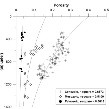
Geologic ages used as references in this study are categorized into Cenozoic, Mesozoic, and Paleozoic. The proposed model of Thai shale data sets from this study will compare with the previous work of Puttiwongrak, et.
LITERATURE REVIEW
Shale Characterization
Compaction Theory
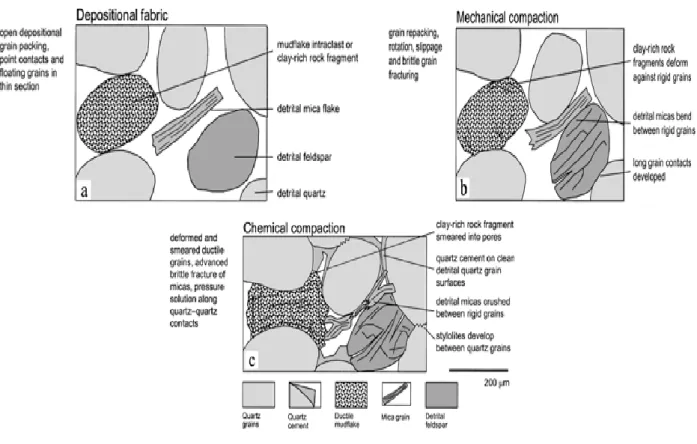
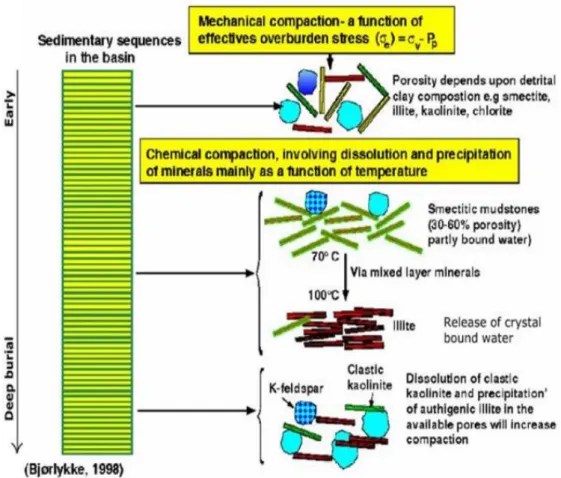
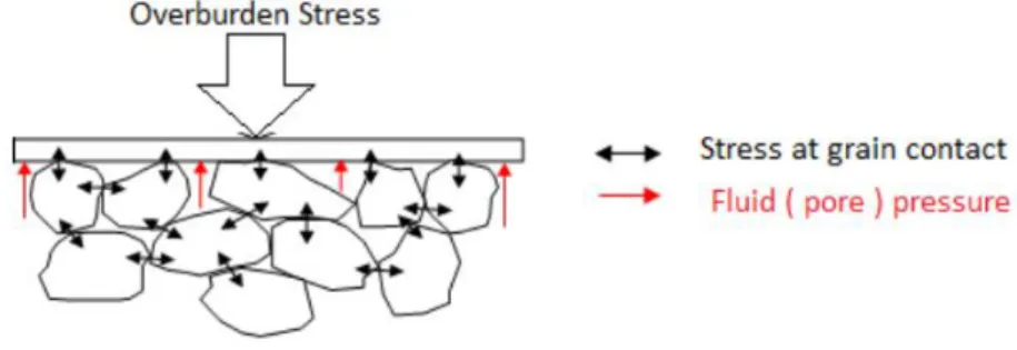
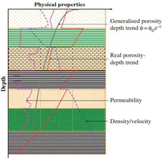
In the diagenetic process of sediment burial, mechanical and chemical compaction is the dominant process that causes changes in the porosity of the original sediment, compared to other processes, namely dissolution, cementation, recrystallization, etc. Mechanical compaction occurs immediately after the deposition process. and consequently increases the hardness of the sediment. The effective vertical stress 𝜎𝑣′ has a significant influence on mechanical compression, but has a small influence on chemical compression.
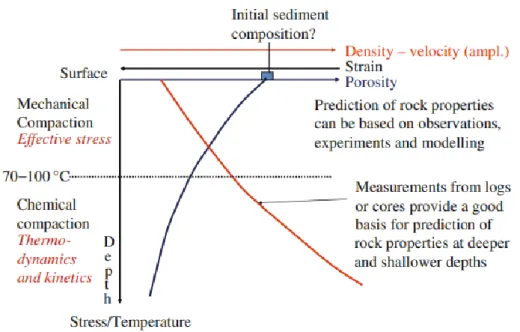
The effective vertical stress as well as the mechanical and chemical compaction effects are reduced by increasing the pore pressure. The mechanical compaction as a function of effective vertical stress and depth and the chemical factor with increasing depth for chemical compaction are illustrated in Figure 2.4. The mechanical compaction change to predominantly chemical compaction is not set in stone and will be influenced by mineralogy and burial history (Bjorlykke, 1998).
At grain size, chemical compaction involves disequilibrium-induced breakdown of minerals and precipitation of more thermodynamically stable mineral assemblages. The relationship between porosity and depth can explain the mechanical and chemical processes of compaction, as shown in Figure 3.5. Shales are mechanically compacted as a function of actual loading until chemical compaction takes over, at which point subsequent compaction is largely determined by temperature and time.
Thailand Geological Setting
The stratigraphy of Precambrian metamorphic rocks in western Thailand was first reported by Brown, et al. Lower Paleozoic rocks of Cambrian to Ordovician age can be found in the southern and western parts of the Shan Thai terrane, but no record mentions Lower Paleozoic rocks in the Indochina terrane in the northeast of the country. The Tarutao Group is the lowest unit in the Lower Paleozoic located on Ko Tarutao Island in Satun Province, Southern Peninsula.
Middle Paleozoic sediments, the area is widely distributed by metamorphic and metavolcanic rocks including east of the western mountains in the Sukhothai fold belt. The Pak Chom Formation in the Loei Fold Belt (in Ban Nong, Sangkhom District, Nong Khai Province) is thinnest Middle Paleozoic sediments containing Silurian shales, phyllites, quartzites, metatuffs and fossiliferous limestones and unconformably with rocks of important, with Namo groups volcanic activity (Bunopas, 1983). Fine-grained Lower Carboniferous sediments are found only in the southern peninsula, containing Posidonomya sp.
Mudstone and sandstone of Kaeng Krachan Group In the southern and southwestern region represent the Carboniferous-Permian. Non-marine species are mainly found in the northeast (Khorat Plateau) and to a lesser extent in the southern peninsula. Non-marine rocks in the southern peninsula include russet claystones, siltstones, sandstones, and conglomerates.
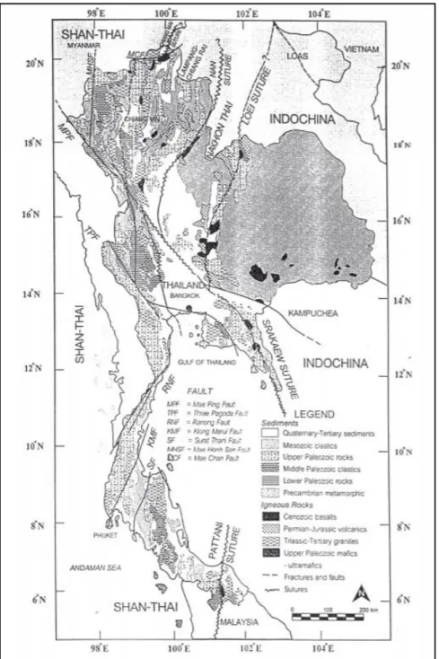
Thailand Basins and Regions
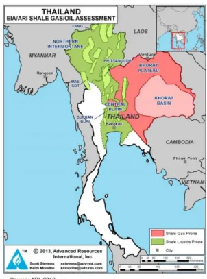
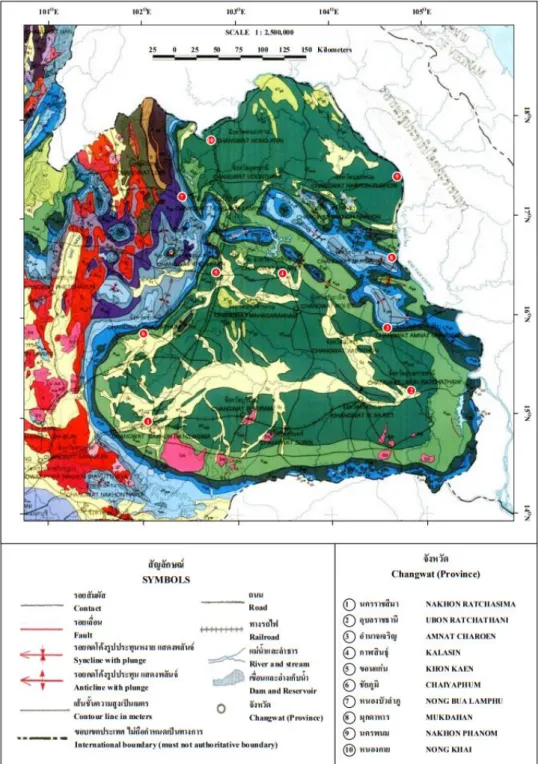
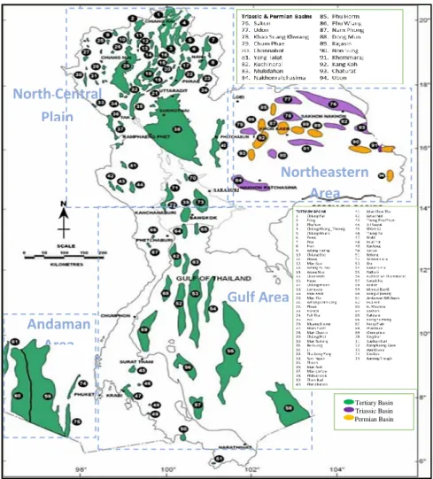
According to Advanced Resources International (ARI), the main deposits of shale in Thailand are located in three major onshore sedimentary basins of Thailand in the North-Central and Northeastern regions of Thailand (Figure 2.8). Those deposits may contain unconventional oil and gas. Exploration in the Fang area is very active, while activity in the other areas is very limited. It is split into two sedimentary basins by the Phu Phan Range, the Khorat in the south and the smaller Sakhon Nakhon in the north.
Seismic data from the Khorat Plateau and petroleum exploration wells show the presence of numerous Paleozoic and Triassic basins at depth, with outcrop analogues in the Loei-Phetchabun Foldbelt to the west (Löffler et al, 1984; Booth and Sattayarak, 2011). The region subsided during uplift and erosion in the late Triassic and later became covered in thick non-marine Mesozoic redbeds. Most of Thailand's petroleum comes from offshore tertiary basins in the Gulf of Thailand, the most notable of which is the Pattani Basin, which has been producing gas for 24 years.
Certain oil and gas reserves have been identified in the Pattani and North Malay Basins. Bidding is open on blocks throughout the Gulf, but mainly in the north and south. Two undiscovered gas prospects, as well as several gas shows, are located in the Oligocene sandstones.
Geological Age
The shallow and deep water areas of the area are separated by the shelf margin. Early Miocene sandstone and carbonate buildups generated on the horst and shelf margin are of exceptional quality and may be potential reservoirs. Oligocene and early Miocene sandstones and shales containing a lot of organic matter could be used as oil and gas source rocks.
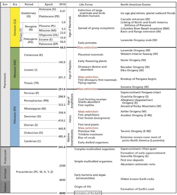
The maturity of the source rocks, as well as their ability to function as a trap, are also factors that come into play in this exploration. The geological time scale (Table 2.1) is a timeline that records an entire history of the Earth. The time scale was created by studying rock faces and fossils around the world.
One of the most essential aspects of Earth Science investigations is the age of the earth (Balasubramanian, 2014).
Effect of Time of Shale Compaction Curve
The study by Puttiwongrak, et al., (2013) compared, revised and reconstructed the published porosity-burial depth data of mudstone from different locations, geological ages and geothermal gradients. This study classified all records according to their geological time (young and old mudstone) and temperature (high and low), which are an important factor influencing mudstone compaction. For the time effect on mechanical compaction, this study showed that porosity decreases with increasing time at constant depth (or overburden pressure).
For the temperature effect, this study showed a decrease in low porosity due to an increase in geothermal energy. Another currently published study by Puttiwongrak, et al., (2020), used the shale compaction data from several published data from different sedimentary basins around the world. An easy approach to determining the geologic time of sedimentary burials with respect to depth and time is to look at their relationship to seismic velocities.
The velocity data in the Faust study are from 500 well surveys in the United States and Canada. Where v denotes seismic velocity in meters per second, Z denotes depth in meters, T denotes geologic time in years, and 𝛼 is currently 46.55 and is numerically equal to the velocity in meters per second when TZ = 1.
METHODOLOGY
- Research Framework
- Data Collection and Study Area
- Porosity-Depth Plot Using Conventional Model
- Numerical Estimation of Geological Age Data and Geological Time Classification
- Multiple Linear Regression Method
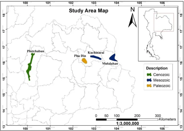
In addition, the geologic age of the data for this study ranges from Paleozoic to Mesozoic to Cenozoic, available burial depths from 280 to 1432 m. The Thai Ministry of Minerals and Fuels (DMF) collected all data used in this study. The data set of this study was plotted in an exponential trend as intended by Athy, also known as a normal compaction trend, the porosity depth plot is shown in Figure 3.3.
The data in this study is divided into three geologic eras: Cenozoic, Mesozoic, and Paleozoic. Faust (1951) proposed a relationship between velocity, depth, and geological time as shown in Equation (5), and to estimate the time at each age, the equation used in this study is expressed as below: However, in this study, the amount of data , used at each age, are sufficiently different from each other.
This study suggests a multiple linear regression for porosity, depth and geological age for the compaction of Thailand clay instead of the exponential trend (Athy's model), to increase the r-squared of the clay compaction curve. This method is suitable to be used in this study to create a compaction model of Thailand clay for porosity, depth and time variables. A statistical technique was used to investigate the relationship of the empirical 3D models provided by this study (porosity, depth, and geologic age) for the Cenozoic, Mesozoic, and Paleozoic data sets.
RESULTS AND DISCUSSION
- Effect of Time on Thailand Shale Compaction
- Thailand Shale Compaction: An Empirical Model of Geological Age Classification
- Standard Compaction Model in Three Dimensions (3D) for Thailand Shales
- CONCLUSIONS
- Conclusions
- Research Gaps and Recommendations for Further Research
The geologic age categorization is required to construct an empirical relationship between porosity, depth and geologic age based on the porosity and depth shown above. This study suggests a multiple linear regression for porosity, depth and geologic age for shale compaction in Thailand (Figure 4.2) rather than one. From the examination of Thailand's datasets, this study explored and highlighted the 3D empirical model in the relationship between porosity, burial depth and geological age in the shale formation of Northeast Thailand.
Although numerical data on geologic age in a shale deposit are difficult to collect, they are derived from Faust's hypothesized relationship between velocity, depth, and geologic age (Faust, 1951). The traditional Athy (1930) exponential model of shale compaction was not fitted to the data to obtain a compaction curve without a geological age classification study. A framework for the compaction curve for the influence of geological time is provided by the significant relationship between porosity, burial depth and geological age of the shale formation over the study area.
Empirical analysis of the relationship between porosity, burial depth and geological age can be used to develop the 3D mathematical model for shale compaction. A 3D empirical model of the relationship between porosity, burial depth and geological age was used to find the standard curve of compaction data for northeastern Thailand shales; this was fully explained in the study conducted by Puttiwongrak et al (2020). Despite the fact that this study establishes a clear relationship between porosity, burial depth and geological age in northeastern Thailand, the proposed compaction model is fit to the data rather than the traditional paradigm (Athy, 1930).
Paleogeographic history of western Thailand and adjacent parts of Southeast Asia: a plate tectonics interpretation. Project: Mapping Black Shale Formations for Shale Resource Prediction, Siem Reap, Cambodia. Geological Societies of Thailand and Malaysia, Bangkok Quaternary Geomorphological Development of the Lower Mun River Basin, Northeast Thailand, Catena, Vol.
Puttiwongrak A., Giao P.H., Vann S., (2020) An easily used mathematical model of porosity change with depth and geological time in deep shale compaction. Role of Fluid Pressure in the Mechanics of Overthrust Faulting, Bulletin of the Geological Society of America Vol.
VITAE