However, this is not the case and most catchments in South Africa are home to wetlands (Cowan, 1995) and within the interior of the South African Highveld, large floodplain systems are common features of the landscape (Tooth et al., 2004). The hydrogeomorphological differences between Wakkerstroom Vlei and the wetlands described by Tooth et al. 2002a; 2004) are sufficient to warrant an investigation into the factors that controlled the formation and hydro-geomorphological dynamics of Wakkerstroom Vlei.
Aim and objectives
Wakkerstroom Vlei is one of the few wetlands still owned by the municipality (Kotze et al., 1994). There are no gullies along the lower course of the hydrogeomorphic component of the lower floodplain, and the trunk of the river has preserved a meandering channel.

Climate and vegetation
Precipitation in the study area, as shown by precipitation data from two nearby rainfall stations in Volksrust (Figure 2.4, Station VA and VB), is variable over both the short (from year to year) and the longer term (several years). periods. Over longer periods, there is clear evidence for cyclical shifts between relatively wet rainfall periods (Figure 2.4, 'Wet cycle') and above-average annual rainfall (623 mm/year, Figure 2.4, 'Average annual rainfall over the period of record'). and relatively dry rainy periods (Figure 2.4, 'dry cycle') with below-average annual rainfall lasting for periods of four to ten years.

Socio-economic characteristics
At the same time, drainage of the tributary stream would be essential in influencing the dynamics of lateral migration of the river trunk. Sediment deposition in these alluvial fans resulted in disconnection of tributary streams from the main channel.
Broad-scale physiography and climate of southern Africa
A clear east-west rainfall gradient exists, with the eastern and southeastern coastal areas receiving significantly more rainfall than the interior and western regions of the subcontinent. These modern features of the South African environment are inherited from unique geological and climatic events associated with the incorporation and subsequent separation of the African continent from the supercontinent Gondwana.
The pre-Cenozoic environment
This major erosion cycle in the history of the South African landscape is called the African Erosion Cycle (King, 1963) and was the first of three major erosion cycles of the South African landscape. This was further enhanced by the establishment of the cold Benguela Ocean Current during the late Miocene (~14 million years ago) (Tyson and Preston-Whyte, 1988).

The Cenozoic environment
For example, during the Miocene and Pliocene, significant amounts of basaltic and Karoo sediments were removed from inland South Africa and rivers superimposed on the underlying Karoo dolerite dikes and sills, which exert extensive structural and lithological controls on the behavior of alluvial rivers in the South African region (Partridge). and Maud, 1987; de Wit et al., 2000). Shorter-term precipitation variations have been superimposed on these longer-term climate trends and are a unique feature of the modern South African climate (Tyson et al., 2000; Tyson and Preston-Whyte, 2000). These variations range from millennial to decadal shifts between relatively warm and wet and relatively cool and dry conditions (Scott, 1989; Talma and Vogel, 1992; Tyson et al., 2002; Holmgren et al., 2003).
In particular, there is evidence for pronounced quasi-cyclic fluctuations in precipitation over periods between ~500-800 years, ~80 years and ~18 years (Tyson et al., 2002).

Accomodation for wetland formation in southern Africa
Over long periods of time, a river tries to reach equilibrium throughout its longitudinal profile by lowering the longitudinal slope to the lowest position within the landscape, which is the global base level (sea level), thus achieving no net erosion or deposition along its length. Schumm, 1977). The feature that limits the depth to which a stream can lower its bed is known as the base level. Rivers are also classified in response to local base levels along the drainage line which may exist for example in the form of resistant rocks.
Rivers respond at different spatial and temporal scales according to the nature and magnitude of change in the external variable (Dollar, 2002).

Current concepts of wetland formation in southern Africa
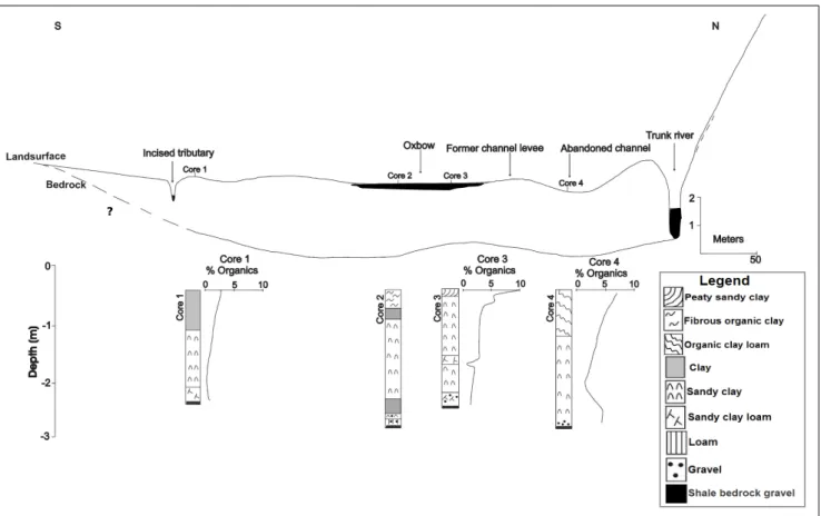
The slope of the valley bed is gentle at an average of 0.17% along the length of the VB, and the trunk river disappears where it enters the VB (Figure 5.6). At the top of this lobe of sediment, gullies are formed and preferably drain along the eastern side of the wetlands in front of alluvial fan I (Figure 5.6). However, a sharp localized peak in organic content occurs just west of the trunk channel at a depth of approximately 0.1 – 0.3 m (Figure 5.11, core 2).
However, in contrast to the extensive floodplain wetlands and meandering channel regions that characterize the broad, gently sloping shale/sandstone areas of the wetland systems described by Tooth et al. 2002a, 2004), within Wakkerstroom Vlei the trunk river flows out along the valley floor hydro-geomorphic component. As indicated by the examination of historical aerial photographs, gullies form along the outflow zones of the wetland wax and wane. This would have promoted a rapid and widespread dispersal of water from the trunk river where it enters the broad, outflowing wetlands, promoting increased flooding of the floodplain.
This is indicated by the fact that clay in the valley floor wetlands and organic clay deposits along the floodplain sections of the wetland abruptly overlie the floodplain sedimentary sequences. The formation of alluvial fans and the consequent damming of the valley trunk were mainly controlled by the dolerite local base control of the river trunk behavior.

Downvalley variation in wetland longitudinal and cross-sectional
The valley bedrock slope is steep at the head of the wetland at 2.57% (Figure 5.3, range 'a') through the UF and the main river meanders extensively through a relatively narrow strip of floodplain for a distance of approximately 450 meters. To the south, the channel has a dike approximately 1 m above the floodplain (Figure 5.4, Along most of the VB shale, lateral walls form on either side of the valley (Figure 5.4, XS5 and XS6).
Towards the lower part of the VB, the wetland valley becomes progressively narrower (~ . 800 m base width), particularly where dolerite (Figure 5.6, 'D3') intrudes for a short distance along the western side of the valley (Figure 5.4, XS7).

Recent (last 70 years) changes in the geomorphological characteristics of
Within the upper limit of the LF the flood plain is narrow (width ~ 200 m) where two alluvial fans (I in the west and J in the east) occur in opposite positions, contributing to the narrowing of the LF in this region (Figure 5.7) . In this region, the dynamic nature of the meandering river is indicated by the density of abandoned meander bands (Figure 5.7). Also evident in the 1938 aerial photograph is the existence of a reforming channel tract (Figure 5.9, 'reforming channel') across the flood zone, which flowed for a short distance before flooding again and forming the large sediment alluvial. prominent lobe along the upper margin of the LF (Figure 5.9, 'paleoflood-out 2').
This second outflow sediment lobe is significantly larger than that of paleoflood-out 1 due to the absence of the confining influence of striking alluvial fans along the lower parts of the VB component of the wetland.

Characteristics of wetland sedimentary fill
Similarly, along the valley floor hydro-geomorphic component reaches of the system, the widespread occurrence of a basal layer of shale fragments provides evidence of historic bedrock planation by a laterally migrating river channel. Similarly, along this second outflow zone, downstream steepening promoted the formation of gullies draining into the Thaka River along the lower floodplain hydro-geomorphic component of the wetland. Channel straightening and buttressing along the upper reaches of the lower floodplain hydro-geomorphic component are instead associated with steepening along the wetland downstream of the reforming trunk channel outflow sediment lobe.
Geomorphology of the Nile River and floodplain in the Northern Semi-Arid Province, South Africa.
The origin and development of Wakkerstroom Vlei
Within this environment, the alluvium would have been maintained as a relatively thin layer over the valley floor by the continuous shifting of the river channel and reworking of floodplain sediments. In this regard, the power of the trunk river, and thus its ability to migrate laterally across the valley, would have been greatly enhanced along the center of the system by inputs of water and sediment from several tributaries adjacent to the trunk channel from both sides of the valley. As a result, the parent river lost channel confinement along the broad, gently sloping floodplain valley that only reaches and maintained flow along narrower and steeper dolerite-influenced valley areas within the upper and lower regions (upper floodplain and lower floodplain hydrogeomorphic components, respectively) of the system (Figure 6.2, Time Phase 'C').
Furthermore, the total depth of alluvial fill along the valley floor hydrogeomorphic component of the system is approx. 4.0 - 4.5 m, which is larger than expected for a laterally planed and filled floodplain system, such as the systems described by Tooth et al. .
Flood-out formation and hydro-geomorphic variation
The Stillerust Vlei appears such that, rather than closure of the tributary stream valley by sedimentation along the trunk river valley, within the Wakkerstroom Vlei, sedimentation by lateral impingement of tributary streams has led to closure of the trunk river valley. When tributary streams entering the floodplain at regular intervals from both sides of the valley contribute significant amounts of sediment to the trunk valley, the dynamics of lateral migration of the trunk river along the midstream of the wetland valley is reduced by the closure of the trunk river valley. The question of what determines trunk or branch dominance in wetland evolution is unclear.
Vegetation and especially the dense growth of Phragmites australis across the catchment areas of the system was also key in promoting and stabilizing valley-bottom wetland conditions where flow is diffusive.

Longer-term wetland dynamics
Conclusion
Tributary valley damming in headwater floodplain development: a case study from the KwaZulu-Natal Drakensberg foothills, eastern South Africa. Valley morphology and sediment cascades in a wetland in the KwaZulu-Natal Drakensberg foothills, eastern South Africa. A review of the stratigraphy and sedimentary environments of the Karoo-aged basins of southern Africa.
Geological controls on the formation of alluvial meanders and floodplain wetlands: the example of the Kli River, Eastern Free State, South Africa.


