i
Using spatial design as a tool for crime prevention in low income communities: A case study of Cato Manor in
Durban, South Africa
By
Thabiso Sacolo
A dissertation submitted to the
School of Built Environment and Development
Studies College of Humanities
University of KwaZulu-Natal
Durban
In fulfilment of the post-graduate degree
Master of Town and Regional Planning
Supervised by
Dr Lovemore Chipungu
2016
DECLARATION
I, Thabiso Sacolo (student number: 214584223), declare that;
1. The research reported in this thesis, except where otherwise indicated, is my original research.
2. This thesis has not been submitted for any degree or examination at any other university.
3. This thesis does not contain other persons’ data, pictures, graphs or other information, unless specifically acknowledged as being sourced from other persons.
4. This thesis does not contain other persons' writing, unless specifically acknowledged as being sourced from other researchers. Where other written sources have been quoted, then:
a. Their words have been re-written but the general information attributed to them has been referenced.
b. Where their exact words have been used, then their writing has been placed in italics and inside quotation marks, and referenced.
5. This thesis does not contain text, graphics or tables copied and pasted from the Internet, unless specifically acknowledged, and the source being detailed in the thesis and in the References sections.
Signed
………
Date:
………
iii
DEDICATION
This research is dedicated to all the mothers who are unrecognised backbones of the educational system. The women who do everything to make sure they sacrifice their nice lives for the betterment of the educational system, and also indirectly provide for their children to have better futures and sacrifice their life plans for the fulfilment of the impossible dreams of their families. “A strong woman is a woman determined to do something that others have determined to be impossible” (Marge Piercy).
This work goes to all the women who are strong and courageous like my mother, Dr Thoko Esther Mnisi and it is to say thank you for her work of raising and educating me in every way. She is a perfect example that women are valuable, and as the late novelist Sir.
William Golding (1911-1933) said, "I think women are foolish to pretend they are equal to men, they are far superior and always have been. Whatever you give a woman, she will make it greater. If you give her sperm, she will give you a baby. If you give her a house she will give you a home. If you give her groceries, she will give you a meal. If you give her a smile, she will give you her heart. She multiplies and enlarges what is given to her.
So if you give her crap, be ready to receive a ton of shit!"
GENERAL ACKNOWLEDGEMENTS
First and formost I would like to thank my family for being my support system, my parents, Dr Thoko Esther Mnisi and Mr. Phillip Silenge for their endless support and being great examples. My brothers (Sabelo, Simphiwe, Michael, Mlibatisi, and Fezile) have always helped me throughout my study life, pushed me and motivated me indirectly by looking up to me.
Secondly, my sincere thanks to Dr. Lovemore Chipungu for his productive inputs that helped me structure my research and guided me to make the ideas I had something comprehensible I also could not forget Dr. Sithembiso Myeni for mentoring me and being ever available to give me some scrutiny and support.
I also thank all my classmates, and all my lecturers for all their inputs and positive criticism that helped me pull through with my studies and research.
Most importantly, I would like to thank the National Police Department, KwaZulu-Natal regional police department, Major Zwane, the Cato Manor police staff, the Cato Manor community research participants and the community at large for making this study possible. There would be no study without them so a word of thanks to them.
Lastly, I would love to thank all the pioneers of the field who have paved the way and created a gap of research in this line of thinking. This research would not have been successful without their contribution in terms of prior findings.
v
ABSTRACT
The aim of the study was to explore the possibility of using spatial design concepts to address crime in low income communities. A case study of Cato Manor in EThekwini (Greater Durban) was selected as it was a perfect reflection of the crime problem faced by low income communities. A case study approach was used to better understand why low income areas are associated with high crime rates and then use the first-hand information of the community members to try formulate a spatial design concept that can be efficient and affordable in controlling crime in the area and similar communities.
The study was mainly guided by the Defensible Space theory and principles of the Smart Growth concept. There were three major data collection methods that were used which were structured questions, drawings and focus group discussions for an in-depth understanding of the problem. Moreover, the researcher also did straight observation to try to see the interaction of the people and the nature of the environment. Together the researcher and the participants analysed the problem then triangulated a plan that can potentially address this problem. Ultimately a spatial design that was seen to be potentially most efficient was drawn and refined. The captured data was analysed and interpreted thematically across the data sets approach, addressing all the research questions. The findings were that design is not effective if there is no human effort towards trying to maintain and protect their spaces, however some members felt that participating in the community would expose them to criminals and they will be targeted by the offenders for trying to fight crime. Therefore, this left room for further research on how to encourage participation and nurture a sense of community in a crime sensitive community. The study recommendations would be that all stakeholders get involved in the development and maintenance of the area which means the community must be involved in all stages of development so they can develop a sense of ownership. Secondly the government needs to play an active role in facilitating and funding the project towards maximising the opportunities of the community. Lastly the community needs to take an initiative to form community forums that will deal with monitoring and controlling crime in the area.
TABLE OF CONTENTS
DECLARATION ... ii
DEDICATION ... iii
GENERAL ACKNOWLEDGEMENTS ... iv
ABSTRACT ... v
LIST OF FIGURES ... x
LIST OF TABLES ... xi
LIST OF ACRONYMS ... xi
CHAPTER ONE ... 1
ORIENTATION OF THE STUDY ... 1
1.1. INTRODUCTION ... 1
1.2. RATIONALE OF THE STUDY ... 3
1.3. PROBLEM STATEMENT ... 4
1.4. RESEARCH OBJECTIVES ... 4
1.5. RESEARCH QUESTIONS ... 5
1.6. POSITIONING MYSELF AS A RESEARCHER ... 6
1.7. CONCEPT CLARIFICATION ... 6
1.7.1. Gated communities ... 6
1.7.2. Urban village ... 6
1.7.3. Smart growth concept ... 6
1.8. LITERATURE REVIEW ... 7
1.9. RESEARCH DESIGN AND METHODOLOGY ... 7
1.9.1. Data Analysis ... 7
1.10. RESEARCH SETTINGS ... 8
1.11. DELIMITATIONS OF THE STUDY ... 9
1.12. POSSIBLE CHALLENGES THAT WERE ANTICIPATED ... 9
1.13. UNFOLDING OF THE STUDY ... 10
1.14. SUMMARY ... 11
CHAPTER TWO ... 12
STUDY THEORECTICAL FRAMEWORK ... 12
2.1. INTRODUCTION ... 12
vii
2.2. DEFINITION AND CLARIFICATION OF CONCEPTS ... 12
2.2.1. Gated Communities ... 12
2.2.2. Urban village ... 13
2.2.3. The smart growth concept ... 14
2.2.4. Defensible space theory ... 16
2.3. PRECEDENT STUDIES ... 22
2.3.1. International context (The Santiago de Surco) ... 22
2.3.2. International Context (Greenwich Peninsula Millennium Village, London) ... 22
2.3.3. Relevance of precedent studies ... 24
2.4. SUMMARY ... 24
CHAPTER THREE ... 25
LITERATURE REVIEW ... 25
3.1. INTRODUCTION ... 25
3.2. SPATIAL DESIGN AND CRIME PREVENTION ... 25
3.2.1. General arguments and relevance of the spatial design concepts ... 28
3.2.2. Arguments for and against gated communities ... 29
3.2.3. Arguments for and against urban village ... 34
3.2.4. Development of gated communities in South Africa ... 35
3.2.5. Development of urban villages in South Africa ... 35
3.2.6. Current application in South African context (Woodland Hills) ... 36
3.3. ATTRIBUTES OF A SAFER PLACE THAT CAN BE ACHIEVED THROUGH SPATIAL DESIGN ... 36
3.3.1. Limited through movement ... 36
3.3.2. Defensible space and territoriality ... 37
3.3.3. Surveillance ... 38
3.3.4. Physical security and target hardening ... 38
3.3.5. Image/management and maintenance ... 39
3.4. AFFORDABILITY AND MAINTENANCE OF THE SPATIAL PLAN ... 39
3.5. SUMMARY ... 40
CHAPTER FOUR ... 41
RESEARCH DESIGN AND METHODOLOGY ... 41
4.1. INTRODUCTION ... 41
4.2. RESEARCH DESIGN ... 41
4.4. SAMPLING PROCEDURES ... 42
4.5. METHODS OF DATA GENERATION ... 43
4.5.1. Structured questionnaires ... 43
4.5.2. Drawings ... 44
4.5.3. Focus Group Discussion ... 44
4.5.4. Data analysis ... 45
4.6. VALIDITY, RELIABILITY AND RIGOUR ... 46
4.6.1. Credibility ... 46
4.6.2. Applicability ... 46
4.6.3. Dependability ... 47
4.6.4. Confirmability ... 47
4.7. ETHICAL ISSUES AND INFORMED CONSENT ... 47
4.8. PART TWO: PREPARING FOR THE FIELD WORK ... 48
4.8.1. Piloting data generation tools ... 48
4.9. PART THREE IN THE FIELD ... 49
4.9.1. Introducing ourselves ... 50
4.10. DATA GENERATION ... 50
4.10.1. Structured questionnaires as a data generation tool ... 51
4.10.2. Focus group discussion as data generation tool ... 52
4.10.3. Straight observation as a data generation tool ... 53
4.11. DATA ANALYSIS ... 53
4.12. LIMITATIONS OF THE STUDY ... 54
4.13.1. Anticipated limitations ... 54
4.13.2. Unforeseen limitations ... 55
4.13.3. Addressing the limitations ... 55
4.13. SUMMARY ... 55
CHAPTER FIVE ... 56
PRESENTATION OF FINDINGS AND DISCUSSION ... 56
5.1. INTRODUCTION ... 56
5.2. BACKGROUND TO THE STUDY ... 56
5.3. DATA PRESENTATION ... 57 viii
ix
5.4. SUMMARY OF FINDINGS AS ANALYSED ACROSS THE DATA SETS ... 64
5.4.1. Findings generated from structured questionnaires... 64
5.4.2. Findings generated from focus group discussions ... 65
5.4.3. Findings generated from straight observation ... 66
5.5. CREATING THE IDEAL CRIME CONTROL SPATIAL CONCEPT ACCORDING TO THEORY ... 67
5.5.1. Safe living and working ... 67
5.5.2. Physical design ... 68
5.5.3. Role of the community ... 69
5.6. CREATING THE ULTIMATE CONCEPT PLAN WITH THE PEOPLE ... 70
5.6.1. Safe living and working ... 70
5.6.2. Physical design ... 70
5.6.3. Role of the community ... 71
5.7. VARIENCES AND SIMILARITIES ... 71
5.8. THEMES AND CATEGORIES OF FINDINGS ... 75
5.8.1. Efficiency of spatial design in crime management ... 75
5.8.2. Affordability ... 75
5.8.3. Feasibility and management ... 76
5.8.4. Suitable concept ... 76
5.9. SUMMARY ... 76
CHAPTER SIX ... 77
RESEARCH CONCLUSIONS, IMPLICATIONS AND RECOMMENDATIONS ... 77
6.1. INTRODUCTION ... 77
6.2. SUMMARY OF FINDINGS ... 77
6.3. CONCLUSION ... 78
6.4. RECOMMENDATIONS OF THE STUDY ... 79
6.5. SUMMARY ... 80
LIST OF REFERENCES ... 81
APPENDICES ... 89
APPENDIX 1: GATE KEEPERS’ PERMISSION TO CONDUCT RESEARCH ... 89
APPENDIX 2: INFORMATION AND CONSENT FOR PARTICIPANTS ... 90
APPENDIX 3: SIGNED CONSENT FORM ... 96
... 98
APPENDIX 4: STRUCTURED QUESTIONNAIRES ... 99
APPENDIX 5: FOCUS GROUP DISCUSSION GUIDE AND PROMPTS ... 101
APPENDIX 6: ANSWERED QUESTIONNAIRES ... 102
APPENDIX 7: APPROVED ETHICAL CLEARANCE LETTER ... 104
APPENDIX 8: CADASTRIALLY INFORMED EXISITING VISUAL MAP ... 105
APPENDIX 9: CADASTRIALLY INFORMED PROPOSED SPATIAL CONCEPT ... 106
APPENDIX 10: TURNITIN RESULTS ... 107
LIST OF FIGURES
Figure 1: Locality map of Durban from Africa, South Africa, and KwaZulu-Natal respectively ... 8Figure 2: Principles of smart growth ...15
Figure 3: Benefits of a smart growth concept ...16
Figure 4: Attributes of Defensible Space ...18
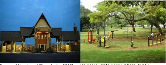
Figure 5: Woodland-Hills gated community entrance gate...30
Figure 6: Woodland-Hills recreational park with outdoor gym ... 30
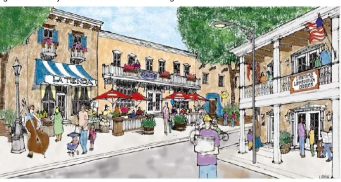
Figure 7: Activity attractions in an urban village ... 30
Figure 8: The researcher and assistants in the respective groups conducting a door to door household survey ... 51
Figure 9: Discussion, sketching and eating during the focus group discussions ... 61
Figure 10: Final visual map of Cato Manor reflecting the crime hot spots ... 60
Figure 11: Ambulance on standby near the tavern and local taxi rank ... 61
Figure 12: Dark roads and streets with no lighting ... 61
Figure 13: Pedestrian getting mugged and harassed in the dark streets ... 62
Figure 14: Community protest against crime and poor service delivery ... 63
Figure 15: The ultimate spatial concept for Cato Manor ... 74
xi
LIST OF TABLES
Table 1: Research assistants ... 50 Table 2: Categorised findings ... 67
LIST OF ACRONYMS
1. GC: ………..Gated community 2. UV: ………...Urban Village 3. UKZN………University of KwaZulu-Natal
CHAPTER ONE
ORIENTATION OF THE STUDY
This chapter presents the background to the study. It begins by setting the context to the study, providing a rationale for the use of spatial design as a crime control tool. This is followed by a description of the problem statement, research questions and objectives and the methods that were used to generate the data. Concept definitions are also provided. Lastly, the chapter provides an overview of the full enquiry, outlining what each chapter entails.
1.1. INTRODUCTION
The key focus of the South African government’s housing agenda is:
The establishment and maintenance of habitable, stable and sustainable public and private residential environments to ensure viable households and communities in areas allowing convenient access to economic opportunities, and to health, educational and social amenities in which all citizens and permanent residents of the Republic will, on a progressive basis, have access to housing. This includes permanent residential structures with secure tenure, ensuring internal and external privacy, and providing adequate protection against the elements, potable water, adequate sanitary facilities and domestic energy supply (Section 1 of the Housing Act 107 of 1997).
Revealing from this Act is the government’s commitment towards providing sustainable human settlements. Such provision entails habitable accommodation, access to amenities and security in tenure. As plausible as this Act is, the evidence on the ground suggests that most low-income communities in South Africa, do not meet the minimum requirements of a sustainable human settlement. Recent findings also point to inefficiencies in the way human settlements are planned and developed in South Africa (Todes, 2011: 2012). Mchunu (2006) cites the Institute for Security Studies (ISS) which highlights that South Africa in general suffers social challenges related to high
2 unemployment and poverty levels. These challenges are closely associated with the constant increase in crime and lack of property safety and have raised concerns for personal urban planning and sustainability.
South Africa has been nicknamed ‘the protest capital in the world’ due to the enduring level of service delivery protests from community members (Bianco, 2013). Many explanations have been given for this status quo. Some have argued that violent community protests occur when community members feel that their concerns are being ignored; a situation which is often exacerbated when local authorities respond with force and arrests instead of responding to communities’ demands (Good Governances Learning Network, 2011). Moreover, and especially considering the discriminatory apartheid policies, Atkinson (2008, 58) notes that these mass protests could be a culmination of frustrations that have built up over a long time. Whatever the explanation, it is undeniable that mass protests are an indication that there are problems with the enactment of state policies in responding to social challenges.
Apart from dissatisfaction with service delivery, it has also been noted that many home owners in low income communities are unhappy about the levels of crime in their communities (Levitti, 1999). Undeniably, safety is a key aspect shaping the quality of life, yet it is often ignored in urban planning. Research evidence has shown that violence and crime are social problems often characterised by socio-economic disadvantages (Gilbert, 2004). This gap in the planning of housing settlements suggests that the quality of human settlements is compromised, especially for the poor. It is against this backdrop, that this study was envisaged.
In essence, the study sought to contribute to the field of spatial planning and human settlements by exploring whether spatial design can be an effective crime control tool in low income communities. In order to achieve this, the inquiry assessed the feasibility as well as the affordability and maintenance of the spatial design concepts in the context of low income households.
1.2. RATIONALE OF THE STUDY
This research was initially influenced by a concern of the prevalence of crime in low- income communities. From this initial concern, the inquiry evolved to incorporate the link between crime and town and regional planning, a focus which naturally lent itself to spatial design. The principle aim is to evaluate the link between spatial design and crime control and further explore the extent to which if spatial design concepts can be used as a crime control tool in low-income areas.
It is also acknowledged that there is a gap in policies regarding crime and sustainable human settlements and that the best way to address this gap is to first engage local communities. Consequently, the study sought to engage the community members using participatory methods, such as visual diagrams and focus group discussions in order to get first-hand information of their perceptions of safe human settlements. This method was envisaged to create a level of comfort and involve community members in shaping ideas that can be used in a possible spatial design best suited to solve the crime issues in their communities. This idea was also influenced by the arguments of collaborative planning which advocate that sustainable planning must be with the people since it is for the people especially in a democratic country like South Africa whereby community participation is an important constitutional right.
It is of interest to explore a space that has not often been explored in terms of research in the past. There is plethora of literature on sustainable development and gated communities but nothing much has been explored by researchers in effective usage of spatial design in spaces for the low-income areas which are predominantly occupied by blacks. Current spatial design applied in both cities and elsewhere, were designed and disposed to the users. Moreover, the designs were influenced by the Eurocentric concepts and the users were not given the platform to contribute.
4 In essence, this study is therefore based on the interest of the researcher to generate ideas from participants and use them to develop a concept that can address or control spatial planning related crimes. The spatial concept and themes of the research are highly influenced by the information generated through the engagement of the participants. It is anticipated that the study will lay the foundation for many researchers in the field of the built environment since it will introduce an efficient aspect to consider when developing low income areas.
1.3. PROBLEM STATEMENT
Many low-income communities face challenges related to functionality, access to services, crime control and maintenance (Todes, 2012). Although the Government invests billions of Rands in these communities, there are further concerns of efficiency in service delivery. In this study, an assumption is made that the association between low- income areas and crime can be explained through spatial design. The Good Governances Learning Network (2011) points out that there are inefficiencies in the way communities are planned and developed which has led to dissatisfaction among community members, inevitably leading to a lack of sense of community and ownership. The poor spatial design and dissatisfaction of community members can be said to be the major contributors of crime in low-income communities, which is in contrast with housing policies, and goals that advocate for sustainable and safe communities. Levitt (1999: 95) points out that “the poor are more likely to be victims of robbery and aggravated assault, and this relationship has remained true over time.” The stigma of low income communities being associated with crime is the motivation of the research as it is recently seen as a fact rather than just an assumption.
1.4. RESEARCH OBJECTIVES
This research primarily stems from one research objective but broken down into different sub-objectives. These objectives are structured as follows;
Main objective;
This study aims to explore the possibility of using spatial design in low income communities, as a tool for addressing their functional inefficiencies and crime
Sub-objectives;
To investigate the extent to which spatial design concepts can minimise the issue of crime in low income residential developments
To examine the feasibility and efficiency of spatial design methods in solving functional inefficiencies in low income communities
To evaluate if spatial design concepts can be affordable and maintainable in the context of low income residential developments
To propose a spatial design concept that can address crime in the area of Cato Manor
1.5. RESEARCH QUESTIONS
This research was guided by one research question but supported by other subsidiary questions. These questions are structured as follows;
Main question
Can spatial design possibly be used as an effective tool for addressing crime in low income communities?
Subsidiary questions
Can these different spatial design concepts minimise the issue of crime in low income developments?
Can these different design methods be feasible and efficient in solving functional inefficiencies in low-income communities?
Can these design concepts be affordable and maintainable in the context of low income developments?
Which of these spatial designs can be most effective in addressing crime in the area of Cato Manor?
The study will focus largely on the prevention and or reduction of acquisitive crimes such as burglary and robbery in residential dwellings; street crimes like theft of vehicles, mugging and theft from vehicles, and other associated offences excluding domestic crimes, homicide and abuse. Therefore, due to the nature of these crimes the study will focus on residential areas and the areas surrounding the properties within the greater residential community.
6
1.6. POSITIONING MYSELF AS A RESEARCHER
The researcher is a built environment student who comes from a background of construction and land use management, and has had first-hand experience of living in a low-income neighbourhood. This background has enabled him to develop an understanding of both the crime control spatial concepts and observed the loopholes regarding safety in the context of low income communities which developed the desire to pursue the study.
1.7. CONCEPT CLARIFICATION
The concepts involved in this study are clarified below:
1.7.1. Gated communities
Gated communities are enclosed residential neighbourhoods that have non-residential amenities within the development; these neighbourhoods are inclusive of recreational facilities, socio-economic facilities and can be for both the financially well off as well as low-income earners depending on the features or facilities (Blakely & Snyder, 1997, p. 2; Landman & Schoneteich, 2002, p.71).
1.7.2. Urban village
Urban villages are urban residential development that are characterised by medium-high dwellings, mixed land use zoning; this includes active public spaces, good public transport and encourages walkability (Landman, 2003).
1.7.3. Smart growth concept
Smart growth is a collection of spatial design principles that influence sustainable land use planning in the modern world, usually in urban contexts. This is a mature concept that can be used as a theory that guides efficient urban development. This concept or theory fosters for mixed land-uses, compact building design, range of housing opportunities, walkable neighbourhoods, sense of community, preservation of open space and
natural beauty, community involvement, provision of a variety of transportation options especially non-motorised, and provides direction of development which makes development decisions predictable, fair and cost-effective. Moreover, the concept is aimed to achieve employment opportunities and preserve or enhance natural and cultural resources (Corrigan et al, 2004; Craig, 2011; US Environmental Protection Agency, 2011;
Katz, 2002).
1.8. LITERATURE REVIEW
The literature reviewed takes on both a local (South African) and international perspective. Specifically, the review focuses on crime in low income areas and the interrelationship between spatial design and crime control. Further, case studies where spatial concepts have been applied are discussed. The theoretical constructs guiding the study are also reviewed. These include concepts that feed sustainable development as well as Defensible Space Theory.
1.9. RESEARCH DESIGN AND METHODOLOGY 1.9.1. Data Analysis
The data will be analysed and presented thematically across all data sets (which are mainly structured questionnaires and focused group discussions) and both outcomes of the data sets will be presented in all themes for a clearer analysis. The researcher chose to use Tesch’s descriptive technique to identify the units of meaning and look for emerging themes that are informed by theories and concepts (Creswell, 2013). Qualitative data analysis was chosen for this study to organise the generated data into categories and to identify patterns among the categories (De Vos, 2005). With this process the researcher was able to draw conclusions which were in line with the critical questions, and also reflect the theories of the study (Babbie & Mouton, 2004).
For this study, the recorded data that emerges from the focus group discussion following the viewing of the researcher’s drawings on gated communities is transcribed verbatim as a means of eliminating researcher bias. The data from the structured questionnaires is then divided into meaningful analytical units, which were organised, summarised, identified, and linked to patterns and themes. This was done through data coding and
The structured questionnaires were followed by focus group discussions. The thirty- people formed part of the three sets of focus group discussions. Each group consisted of ten people; nine were general community members and one was a member of the police force who was used as a key informant. To guide the discussions, diagrams and visual aids were also used as a supportive tool to generate additional information.
Two sessions were planned with three groups of ten participants. The reason for dividing the large group into 3 was to enable control of the group discussions as well as to capture everything during the interaction. Each session lasted between 1 – 2 hours. The first session focused on sourcing the drawings/diagrams reflecting the participants’ visual map of their community. The aim was to bring forth data and gain insights from the participants on possible crime spots, exit points and the nature of crimes thereof. The second session mainly focused on how the spatial designs can be used to improve the participants’ local community. The visuals were used to guide the discussions and all discussions were audio recorded.
1.11. DELIMITATIONS OF THE STUDY
The study is located in the field of Town and Regional Planning and Human Settlement and it focused on exploring the extent to which spatial design concepts can be used as an effective crime control tool in low income communities. This included assessing the feasibility and ultimately determining the most appropriate concepts for application in the human settlement chosen.
1.12. POSSIBLE CHALLENGES THAT WERE ANTICIPATED
This was a small scale, qualitative study based on one low income area so, the findings may not be a true reflection of the population or other communities with similar characteristics. Secondly, there was a concern that the latest crime statistics could not be accessed by the public. Other issues of concern were that there was no assurance on the availability of participants and their willingness to participate. Moreover, there was a concern that the time frame of the study would limit the depth of the study and engagement of the researcher with participants. The researcher planned to deal with the problems by
10 acknowledging these limitations, use random sampling to create unanimity and also refer to the currently existing crime statistics to address these intentions. Moreover, the researcher planned to use the focus group discussion approach to generate more information within the short period of time and also cover the gaps left out by the statistics.
1.13. UNFOLDING OF THE STUDY
The dissertation is structured into six chapters, in which each contains a different aspect of the research, which are summarised as follows;
Chapter one
This chapter presents a generic outline of the study, which involves the motivation to use spatial design as a crime control tool. It also presented the aim and objectives of the study.
Chapter two
Chapter two presents the literature relating to the concepts and theories used in the study.
The focus is on the smart growth concept, gated communities, urban villages and the theory of defensible space. The literature reflects the background of the concepts and how they have evolved over time. Moreover, two precedent studies are introduced to reflect their relevance.
Chapter three
In this chapter, critical literature arguments will be reviewed, focusing on the development of gated communities in South Africa, and how the urban village or gated community concepts can be used as a crime prevention tool. The chapter will also draw arguments for and against these spatial design concepts and theories. Ultimately, it will draw on literature reflecting the interrelationship between the theory of defensible space and the concepts being explored in the study, which are the urban village and gated community concept.
Chapter four
This chapter will outline the study methodology and design. As already indicated, a case study method nested in a qualitative approach was adopted. The chapter will also reflect on the sampling methods and data generation tools such as the structured questionnaires and FGDs, which will be used in this study. The strengths and weaknesses of the chosen tools will also be discussed.
Chapter five
This chapter will present, analyse and discuss the data that was generated in the research. The data will be presented thematically across the data sets and analysed against the literature and theories adopted in this study. The ultimately drafted spatial concepts of Cato Manor will be presented and discussed in this chapter.
Chapter six
This chapter will present conclusions and recommendations from the findings drawn from the entire study. This chapter will also present the implications of the research findings and further outlines the limitations of the research as well as suggests further research that could be pursued.
1.14. SUMMARY
The chapter introduced the study which is aimed at exploring the use of spatial design to control crime in low income areas. It presented the objectives and rationale of the research. Chapter two will present literature on the concepts and theory used in the study, and it will further introduce the precedent studies that were selected for the study.
12
CHAPTER TWO
STUDY THEORECTICAL FRAMEWORK
2.1. INTRODUCTION
This chapter presents the synthesis of literature relating to the concepts and theories that were used in this study. The focus was on the smart growth concept, gated communities, urban villages and the theory of defensible space. The literature reflects the background of the concepts and how they have evolved over time as well as two precedent studies whose conceptual relevance to this study is explored.
The study is primarily underpinned by the principles of the smart growth concept.
Concepts of sustainable development and new urbanism are also considered, since they share common principles with the smart growth concept. This is because all three concepts deal with mixed land use developments and safety which is basically incorporated in the proposed concepts of gated communities and urban village used for this study. The study also touched on concepts such as the neighbourhood concept, non- motorized transport and collaborative planning. Newman’s defensible space theory is also discussed.
2.2. DEFINITION AND CLARIFICATION OF CONCEPTS
The next section clarifies the related concepts with the aim of introducing the conceptual framework in use for this study.
2.2.1. Gated Communities
In this study gated communities refers to;
“a generic term that includes enclosed neighbourhoods that have controlled access through gates or booms across existing roads, and security villages and complexes, including lifestyle communities which provide their enclosed residents with a range of non- residential amenities such as schools, offices, shops and golf courses” (Landman &
Schoneteich, 2002, p.71).
This definition ties up with Grant (2005) cited in (Blakely & Snyder, 1997, p. 2) who defines gated communities as “residential areas with restrictive entrances in which, normally, public spaces have been privatized.” They can be a totally new developments or old reconstructed and vitalised areas, and also they can be developed in cities or suburbs, in either high income areas and/or poor neighbourhoods.
What should be noted from this definition is that gated communities have controlled access and their principal purpose is to offer security to the residents. They are enclosed and have non-residential amenities within the development, including recreational facilities. Moreover, gated human settlements can be found in both low and high income neighbourhoods.
2.2.2. Urban village
An urban village (UV) can be defined as an urban development that is characterised by medium-high density housing, mixed land use zoning, good public transit and encourages walkability and public space (Landman, 2003).
The concept can be properly traced back to the 1980s in Britain and the Urban Village Group (UVG) promoted it as a means towards achieving more human scale, mixed-use development and well-designed physical spaces. The concept has since been used in the planning discourse, and there are many developments built in line with the concept since then (Franklin & Tait, 2002).
Sucher (2010) narrows the concept by outlining the three rules that guide the development of an urban village. These are:
Build to the side walk
Make the building front more permeable
Prohibit parking in front of the buildings
The urban village concept is more common in Chinese cities but has gradually been accepted globally as a means of rapidly providing rural migrants with housing that is easily accessible and affordable, and also providing decent, sustainable and safe
14 accommodation (Hao, Geertman, Hooimeijer & Sliuzas, 2013).
2.2.3. The smart growth concept
Although there is evidence that the smart growth concept was aimed at managing urban growth of the 1960s and the revolution of the 1970s and 1980s, its roots can be formally traced to the 1990s. Knaap (2006) comments that the concept was first introduced by the American Planning Association in the 1990s and was later drafted in the first edition of the Growing Smart Legislative Guidebook in 2002. Edwards and Haines (2007) state that the co-drivers of the Smart Growth and Neighbourhood Conservation Act was Maryland in 1997 that launched it as a public policy. Still, there is evidence suggesting that the concept first emerged formally in 1992 during the United Nations Environment and Development Conference which was held in Rio De Janeiro for the adoption of Agenda 21 (Haines, 2007; Knaap, 2006).
While there is lack of consensus regarding when it originated, it is generally accepted that the smart growth concept came as an initiative to try to minimize the issues of urban sprawl, traffic congestion, disconnected neighbourhoods, and urban decay, which come with the changes in urban dynamics (Bullard 2007). Therefore, the concept focuses on future growth and infill development close to jobs, services, and public facilities to maximize the use of existing infrastructure and preserve open space and natural resources (Sandag, 2006). Litman (2012) views smart growth as an urban planning tool for energy efficient design, highlighting transport systems as its main tool in achieving this.
The concept further introduces planning principles based on transport systems that use various modes of transport and efficient land use patterns that came about as a counter intervention to the problem of increasing sprawl.
Szold and Carbonell (2002) argue that smart growth aims to achieve the principles of sustainability since it places high environmental consideration and preservation as well as socio-economic well-being and advancement. Smart growth is concerned with the use of a residential area which is transit-oriented, thereby maximising the use of public transport, bicycle riding and walking. Apart from being transit-oriented, smart growth communities also include mixed use development, and include infrastructure such as
ideas of increasing the quality of social security through spatial design emerged in the 1930s. During this period, it was done through the manipulation of the physical architectural features to shape and alter some of the safety issues and to manage social interaction among residents with use of public housing bureaus (Schneider & Kitchen, 2007; Zen & Mohamad, 2014).
Newman’s defensible space line of thought has been developed over the years and incorporated into the theory known as Crime Prevention through Environmental Design (CPTED) that has emerged and been adopted worldwide as one of the most effective strategies of controlling and reducing crime in neighbourhood developments (Ekblom, 2014). C. Ray Jeffery was the first to coin the concept CPTED in his published book called
“Crime Prevention Through Environmental Design”. However, his publication never got much credit until a year later when Oscar Newman came with his own publication called
“Defensible Space: - Crime Prevention through Urban Design". This theory of defensible space was revised to incorporate other approaches that were supported by the CPTED strategy and Newman gave credit to Jeffery who was the one who coined the name CPTED. Jeffery CPTED which was a mere improvement of Newman’s theory of defensible space was a great success so as a result Ray Jeffery’s work was re-examined (Crowe & Zahm, 1994; Eck & Weisburd, 2015).
Newman (1972) suggests that defensible space theory creates a social structure that protects itself from potential criminal activities and aims at restructuring or developing an area in a way that allows the residents of that community to gain control over the area of residence through the establishment of common values, common activities and lifestyles.
It is a structure for a residential environment which reflects social strength through the manipulation of the community environment whereby physical attributes are used to create safety features and strengthen community unity and sense of ownership (Newman, 1996).
Newman (1972) further argues that an area is safer and free from crime when people develop a sense of ownership and they feel responsible for that area or specific community. He further states that criminals are isolated and there is less room for crime
environment from public and private spaces, which enables the occupant and neighbours to oversee each other’s space and public spaces from their properties (Welsh, Farrington
& Taheri, 2015).
Mohit and Elsawahli (2010) define image and milieu as the combination of residential dwelling units, commercial structures and recreational facilities that allow natural surveillance. This is the overall appearance and features of the neighbourhood that can create either a positive or negative impression about that particular neighbourhood. This impression will determine or influence crime rates in that particular place; positive impression results in minimal crime activity possibilities as the potential offenders will be scared of committing crime in an area that seems to be well maintained and a negative impression encourages high criminal activity since criminals will see no risk in committing crime in an area that does not seem secured. This also speaks to the overall social environment, the location of the apartments in relation to a police station, community centre and so forth (Eck & Weisburd, 2015; Reynald, 2014).
While Oscar Newman’s conceptual definitions do not explicitly state the interrelationship between natural surveillance, image and milieu, his descriptions clearly reflect that there is an interrelation between natural surveillance, image and milieu and they are co- functional components of territoriality in his defensible space theory. Natural surveillance, image and milieu are vital tools of territoriality and they influence the residents to have control of their environment (Reynald, 2014; Reynald & Elffers, 2009). Therefore, territoriality and its three sub-components are interrelated and linked in a way that the presence or absence of either one of them can either strengthen or weaken territoriality, ultimately determining whether the outcome is a defensible or indefensible space (Reynald & Elffers, 2009).
The defensible space theory manifests its principles through architectural attributes and elements (Zen & Mohamad, 2014). Newman’s focus was on the physical design components that contribute to a safe and secure environment, territoriality and natural surveillance of what might be going on around the neighbourhood. He argued that
20 neighbourhood design can improve space territoriality and natural surveillance which can be an effective tool to control crime, resulting in defensible spaces (Crowe & Zahm, 1994;
Crowe & Fennelly, 2013).
Newman (1996) says the defensible space theory relies mostly on self-help rather than being dependent on government intervention. This improves people’s vulnerability to government’s withdrawal of support while fostering residents’ involvement in the process of reducing the occurrences of crime and removing the presence of criminals in the area. This theory provides an opportunity of mainstream life for low-income people if they take the initiative to better their worlds by taking ownership of their own space and build a sense of community and a safe environment (Newman, 1996; Shjarback, 2014).
Newman was initially criticised for social processes in territoriality (Reynald, 2014). The main argument brought forward was that his defensible space theory neglects complex fundamental social processes that influence territorial functioning. However, Newman addressed the gaps by looking into the social variables that encourage territoriality, and pointed out the importance of having residents with a common mind. He concluded that social characteristics of residents are the ones that predict crime in a development rather than the design itself. This means design alone cannot influence safety without the community having one mind and high sense of ownership of space (Newman 1976; Reynald
& Elffers, 2009).
There is also criticism that the effect of socio-economic and spatial design variables on crime is not sufficient to reveal the role that social factors play in Newman’s conceptual definitions. According to Newman’s theory, the territorial attitude and behaviour of the residents represents a determining factor in creating a ‘defensible space’ as this depends on the residents’ desire and ability to exercise and influence control in their space and surroundings (Reynald, 2014; Newman, 1972, 1976, 1996). However, the model is criticised for assuming that residents can be fully engaged and willing without mentioning the importance of social and psychological processes in influencing territorial functioning (Reynald & Elffers, 2009). Newman’s theory is also criticised for the conceptual ambiguities and failure of being able to identify, define and measure
The relevance of this theory in the study is that it is in line with the arguments of scholars who have studied the relationship between crime and spatial design of neighbourhoods.
The argument is that activities and locations are regarded safe or unsafe based on the presence or absence of natural surveillance, access control, and sense of ownership or territorial behaviour (Crowe & Fennelly, 2013).
The defensible space theory suggests that a spatial design of a community can either increase or limit people’s sense of control and ownership over their space of residence.
Neighbourhood spaces can be categorised into public space (like parks, roads and sports field), semi-public spaces (like the front gardens in front of the property), semi- private spaces (for example, the back garden outside the property) and private spaces (anything inside the property boundary). A defensible space is therefore clearly defined and people are aware of the owner or who is to use that specific space, and this means non-legitimate users will know that they should not be in that space or use it (Newman, 1972; Kim, Lee, Lee, Gordon, Janzen, Mazumdar & Davey, 2013).
Defensible space cannot be achieved by installing of physical barriers only; there must be other subtle symbolic interventions such as a changing the road colour or texture, or narrowing of the entrances to the development which will help in marking the area as private. It is not about physically blocking the people who might possibly be offenders from entering the neighbourhood. Rather, it is about convincing them that the neighbourhood is private and entering it means that they are crossing boundaries. Since the space is private, it also means that they will mostly probably be observed and/or challenged by the residents who stay in and own that particular residential space (Armitage, 2016).
22
2.3. PRECEDENT STUDIES
The study will refer to two international precedent studies. One is Santiago de Surco in an international context and another is Greenwich Peninsula Millennium Village in London.
2.3.1. International context (The Santiago de Surco)
The Santiago de Surco gated community in Lima, Peru was developed 30 years ago, by an association of neighbours from Las Casuarinas. Its primary purpose was to segregate the development to separate the nearby area of Pamplona Alta situated in the district of San Juan de Miraflores. Pamplona Alta is one of the poorest neighbourhoods in Lima (Boano & Demaison, 2012; Sabatini & Salcedo, 2007). The Santiago de Surco has cameras and guards to provide security for houses, which sprawl over 1,000 square metres (10,700 square feet), surrounded by pools and lush gardens. Meanwhile, on the San Juan de Miraflores side, residents often fall victim to robbery and theft. They live in houses of barely 25 square metres (270 square feet), made from scrap material, surrounded by the sand and earth characteristic of Lima’s desert landscape (Boano &
Demaison, 2012; Sabatini & Salcedo, 2007).
In this city, there is a huge contrast of class as most residents of Pamplona Alta live in informal settlements and do not have access to fresh or running water. Instead, they have to pay for water to be delivered by lorries. However, their affluent neighbours across the wall are the elite recognized by public authorities as landowners and they have quality services which include cheap water piped straight to their houses (Duarte, 2012; Sabatini
& Salcedo, 2007).
2.3.2. International Context (Greenwich Peninsula Millennium Village, London) A significant example of a modern urban village that can be seen in an international context is the Millennium Village located in Greenwich Peninsula, London. This urban village was designed by Ralph Erickson and was developed by the Urban Regeneration Agency formerly known as the English Partnership. The community reflects a safe and high quality modern community that presents traditional values of village life with a high sense of community. This was achieved by creating a balanced design of buildings and
public spaces, and creating a variety of transport systems, which includes an integration of public transport but promotes mostly non-motorised transport systems. This comprises pedestrianisation and the creation of a varied and sustainable close-knit urban fabric that allows for different land uses and activities (Landman, 2003; Madanipour, 2001). This modern urban village also incorporates high density residential units with green public spaces and provides opportunities for leisure activities and shopping. Moreover, the design of the village limits car usage and traffic since pedestrians have priority over cars within the community (Ambrosino, 2015).
The main streets of Greenwich Village run through the northwest and southwest borders of the development. There are also two main streets that run through the area which is similar to the layout of Cato Manor in the city of Durban. Therefore, the village serves as a good area of reference for this study. There is a dedicated and coloured two-lane busway which starts at North Greenwich station and passes through the village. On the south side of the village is a road that leads to the school parking lot. Besides these main roads, the development is car-free and priority is afforded to the non-motorised cyclists and pedestrians. Pedestrian and cycling pathways are also provided, which are separated from motor vehicle traffic throughout the village. Furthermore, safety is enhanced through monitoring of transit stops, cycle routes and pedestrian areas by CCTV which is what smart growth, as discussed in Chapter two, is advocating for. In the context of Cato Manor, street side barriers like walls or metal fencing can be used to secure the pathways that are meant for buses and non-motorised transport for the sake of cost efficiency (Ambrosino, 2015).
The main component of the design of the Greenwich Millennium Village was the provision of public spaces. The village includes an ecology park which consists of two lakes and flourishing wildlife, a village square, landscaped courtyards, and garden squares throughout the residential areas. Greenwich Millennium Village was designed to be a mixed-use development combining residences, retail, commercial and leisure spaces.
The area includes a mix of residential tenure types for both high storey buildings located along the Thames River to provide more waterfront views, and a mix of lower rise flats and terraced houses situated around public squares located near the centre of the
24 development, making it convenient to walk or cycle a short distance when conducting shopping or merely viewing the area. The village square includes a small grocery store, a pharmacy and several cafes. The commercial space also has community facilities such as a school and health centre for convenient access of services (Ambrosino, 2015;
Countryside Properties, 2016).
2.3.3. Relevance of precedent studies
Both the Santiago de Surco and Greenwich Peninsula Millennium Village are designed for affluent societies. They have high quality of life, security, services and facilities at their disposal and the low-income earners are side-lined. It can then be argued that the aspect of crime control and prevention from these communities can be adopted to create an efficient similar type of spatial design but in a low-income context. However, issues of affordability, maintenance and community involvement are questionable in the context of low income areas. This study seeks to explore these concepts so as to establish the opinions of people who live in low income communities regarding their feasibility.
2.4. SUMMARY
This chapter introduced the theories and concepts that informed the study. The key principles were also discussed and their relevance to the study established. Furthermore, the study introduced precedent studies and briefly discussed their relevance to this study.
The next chapter will unpack literature that links to these theories, concepts and the precedent studies. It will then present an argument regarding the study which will unpack thematic arguments relating to the objectives of the study.
CHAPTER THREE
LITERATURE REVIEW
3.1. INTRODUCTION
This chapter presents the critical arguments put forth in the literature reviewed in this study, focusing on the development of gated communities in South Africa, and how the urban village or gated community concepts can be used as a crime prevention tool. The chapter also explores arguments for and against these spatial design concepts and theories. The chapter draws on literature that reflects the interrelation between the theory of defensible space and the concepts being explored in this study, which are the urban village and gated community concepts.
Literature review is an integral part of any research process as it lays the foundation for good research inquiry and endeavours (Fouche, 2005). It involves critical reading and examination of existing literature around a researcher’s interest. Thus, various international and local intellectual voices will be engaged with in the chapter to follow in order to contextualise and underpin the study. This involves, but is not limited to, issues related to gated communities, sustainability, efficiency, integration and other aspects in respect of the principles of planning.
3.2. SPATIAL DESIGN AND CRIME PREVENTION
The idea of using spatial design to mitigate crime is not a new concept as scholars like Landman and Liebermann (2005) have previously argued that urban planning can be used as an effective tool to control, prevent and reduce crime in urban areas. Urban spatial planning is already used in the form of gated communities and security villages in creating safe neighbourhoods (Landman & Liebermann, 2005).
The idea of using spatial design as the primary tool of creating a crime repellent neighbourhood is mostly informed by the defensible space theory and smart growth concepts which are rooted in Newman’s thinking, as discussed in the previous
26 chapter. Some authors such as Hillier and Shu (2000) have critiqued Newman’s theory as nothing more than an ambiguous ‘fashionable consensus’ instead of an empirically vigorous theory that can be implemented to control neighbourhood crime effectively.
Armitage and Pascoe (2016) point out that the method of crime prevention through spatial design works by manipulating the built environment to block opportunities for criminal behaviour through indirect techniques that breed informal surveillance, a sense of ownership and guardianship, and set standards of physical security that will limit the risk of the occurrence of crime.
Landman (2004) states that in the context of South Africa where there are high levels of crime, many people consider enclosed neighbourhoods or security villages as the only options for safe living in cities. These spatial designs are seen mostly in wealthy areas but the question of whether these designs could be refined and applied in the context of low income communities to tackle issues of crime must be investigated. This is particularly so because low income areas are highly associated with crime in South African urban areas. Landman & Liebermann (2005) and Zahm (2011) suggest that design that enhances natural surveillance or passive surveillance and a sense of ownership in an area makes it more difficult for people to commit crime, thus spatial design can be used to alleviate the high rates of crime in lower income areas.
Over the decades planning has evolved from a technical outcome-based approach to a more people-centred approach that is based on the needs of the people. This approach also applies in South Africa where it is one of the main forms of planning in the country and is manifested through the Integrated Development Plan (IDP), which also outlines the importance and procedure for public participation. A people-centred approach is also mandated by the South African National Constitution of 1996 and the likes of the Batho Pele principles which advocate for the prioritisation of the people (Harrison, 2006). This prioritisation is even regulated through municipal budgets since the IDP and the budget go hand in hand. This is because no municipal budget can be approved without an IDP being drafted as a means to ensure that the needs of the people are prioritised and
municipalities are obligated to draft an IDP based on the needs of the people. This idea of planning in consultation with the people is the cornerstone of postmodern planning, known as collaborative planning. This consultative approach is applied in most democratic countries as a method of giving people the ability to influence their own development instead of a top down approach being implemented where development is merely imposed on people (Harrison, 2006; Landman & Liebermann, 2016).
In South Africa crime concerns are one of the top three priorities of the country, as outlined in various Municipal Integrated Development Plans. However, there is limited ability to incorporate precise and effective crime prevention strategies into local development plans even though there is a realisation of their importance. On the one hand this poses a challenge in South African communities but on the other it does justify the need for further studies on the issue of crime prevention in spatial design to be conducted (Landman &
Liebermann, 2016).
Using spatial design as a crime prevention tool creates an opportunity for local government to respond to the needs of the people since crime is one of the major concerns of South Africans. The use of spatial design addresses the link between crime and place and aims to reduce the opportunities to commit, and thereby the occurrence of, crime. This can be achieved through the application of sound and effective spatial planning strategies that encourage a sense of territoriality, which will then minimise and control crime incidences by not only imposing physical barriers but through the vigilance of people themselves (Armitage, 2016).
There is a growing realisation that city governments need to better use their bylaws and make more significant efforts towards crime prevention because it is evident that spatial planning is another viable and effective tool to address crime. Landman and Liebermann (2016) suggest that there is a relationship between crime and the places where it occurs, and that this is why many people and businesses are opting for fast growing enclosed neighbourhoods to avoid being victimised. However, they argue for alternative approaches to be implemented to avoid the problems of restricted access and social exclusion resulting from the erection of barriers.
28 There are many benefits of involving residents in the planning and development of integrated safety and crime control strategies for their area and in the management principles of the built environment at large. The benefits include an increased sense of community and territoriality, which creates a subconscious defence mechanism.
Residents will feel like they need to take care of the community, and to maintain and also defend their space as a collective. In turn this makes it risky for intruders to commit crime in these places (Landman & Liebermann, 2016).
3.2.1. General arguments and relevance of the spatial design concepts
The human settlements goals of municipalities in South Africa are geared towards integrated, sustainable and efficient planning. It is evident in previous research that the general opinion in many communities is that most developments do not meet the requirements of sustainable development. The government has committed itself towards improving the sustainability, crime prevention strategies and integration of communities through urban reconstruction and development as an approach to address inequality (Landman, 2004).
Policies such as the Reconstruction and Development Programme (RDP), and Growth, Employment and Redistribution Programme (GEAR) were developed as standard guides for planning which encourages the fulfilment of the basic needs of all people through the development and housing processes (Landman, 2004). According to Mchunu (2006), the Integrated Development Plans (IDPs) contain the guiding principles of sustainability in the context of South African development strategies with the support of the Municipal Systems Act (32 of 2000), which regulates the way municipalities go about implementing development plans. However, the question then turns to how crime can be reduced at neighbourhood level to respond to the crime concerns of the residents, with a special focus on low income areas as they are prime crime areas.
The relationship between spatial design and crime prevention is more than just physical restrictions which make it more difficult for people to be victimised, such as the use of burglar-bars, gates and high walls. Instead the relationship between the two aspects also