The distal-permanently flooded functional type was typically found in the lower parts of the floodplain which were rarely exposed to hydrological and sedimentological inputs from the Mkuze River. The distribution and interaction between these functional types made it possible to develop process-based understanding of the ecosystem patterns and processes operating within the lower Mkuze River floodplain.
INTRODUCTION
The overall aim of this study was to develop an understanding of the vegetation ecology of the lower Mkuze River floodplain from a landscape ecology perspective. To examine the role of anthropogenic disturbance through a spatiotemporal analysis of the landscape mosaic.
THEORETICAL FRAMEWORK
Introduction
The Emergence of the Hierarchical Patch Dynamics Paradigm .1 The Equilibrium Paradigm
- The Alternative Paradigm
- Hierarchy
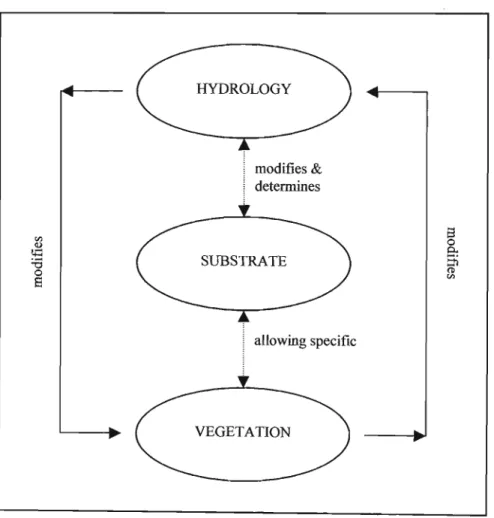
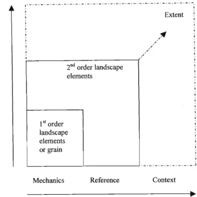
The basic ecological unit of the landscape mosaic is the landscape element or site (Forman, 1995). The granularity of the floodplain environment can be examined through the constituent variables of wetland patterns and processes.
STUDY AREA
Context
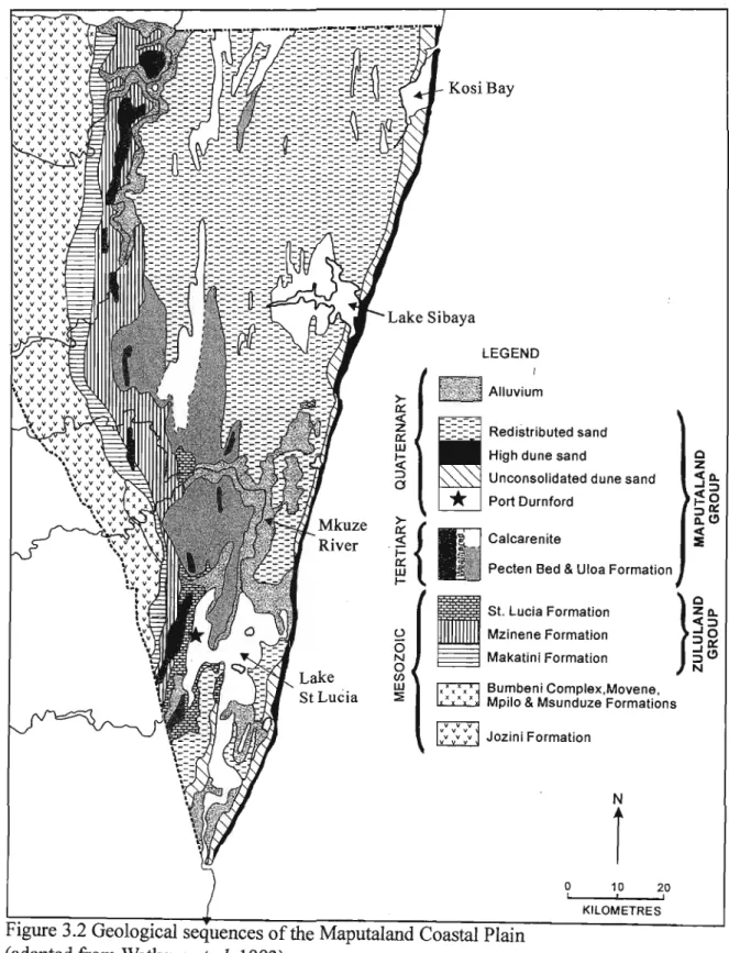
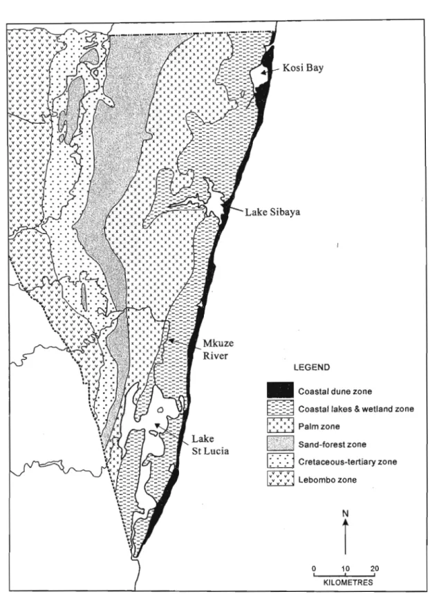
- Local Geology and Geomorphology
- Hydrology
- Vegetation
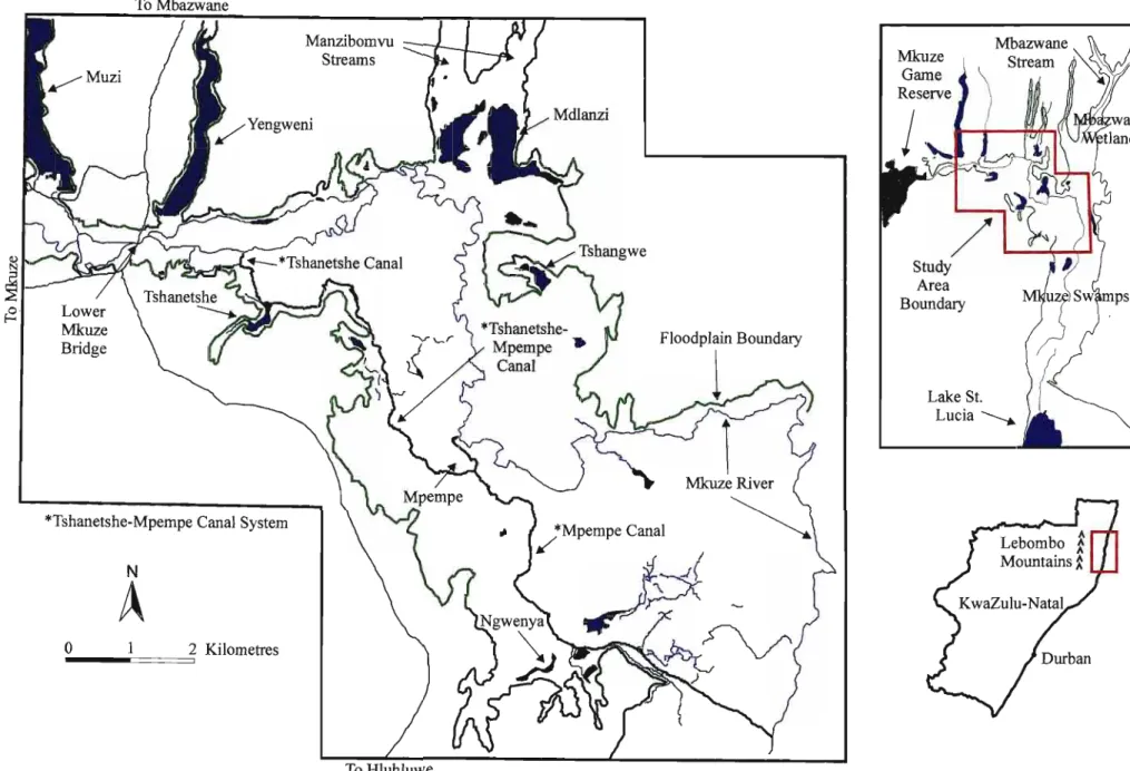
This process is evident in the west to east extension of the lower Mkuze River floodplain to the Mkuze Swamps. However, a history of mismanagement in this regard has resulted in the alteration of the hydrological regime within the lower Mkuze River floodplain (Alexander, 1986; Taylor, 1986; Goodman, 1987).
VEGETATION ECOLOGY
Introduction
Methodology .1 Data Collection
- Vegetation Data
- Classification
- Ordination
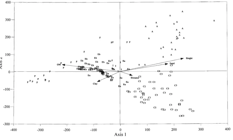
The ordination process also generates a weighted correlation matrix that aids in the interpretation of the correlation between each ordination axis and the environmental variables. After extraction of the ordination axes, the sample spread was analyzed in relation to the environmental variables measured in the field, i.e.
Results
- Classification
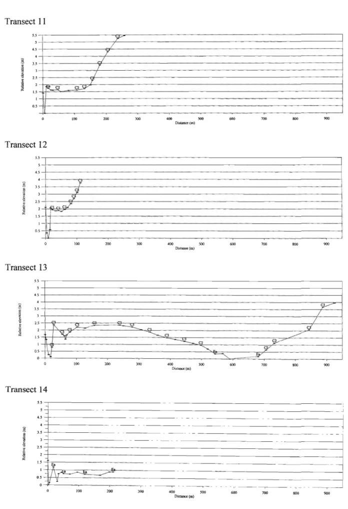
- Plant Community Distribution in relation to Topography Transects 1 to 6
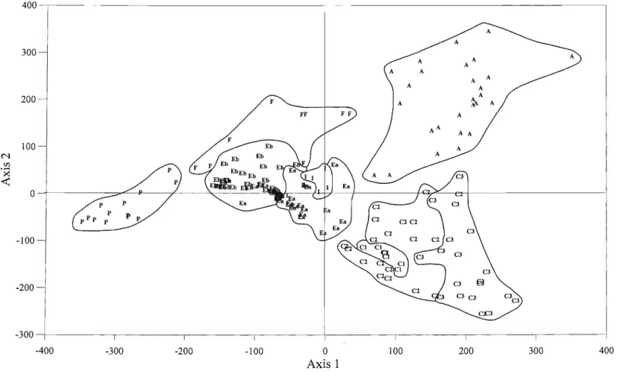
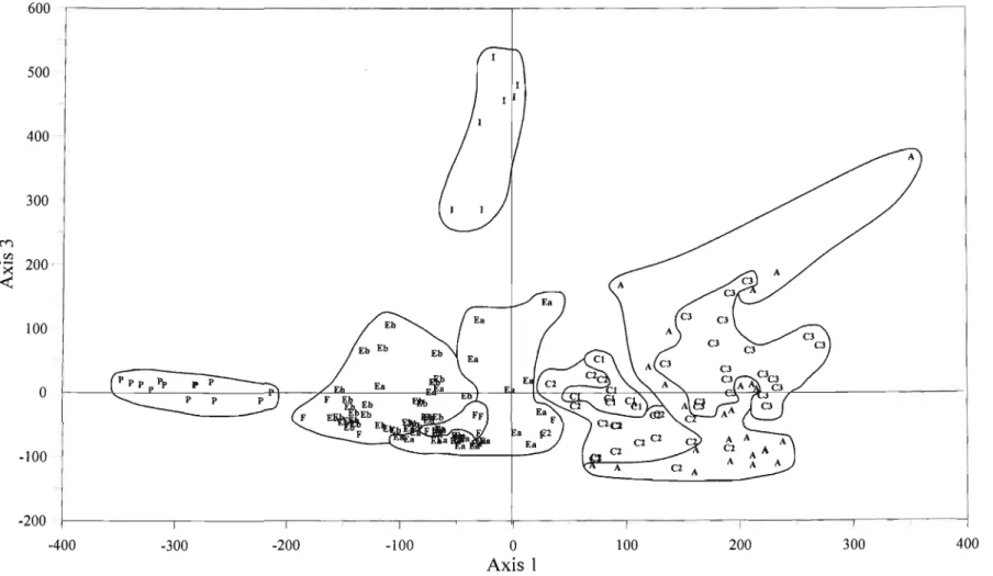
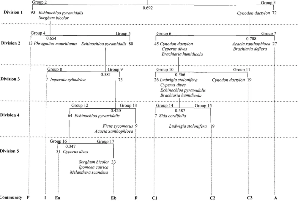
Subsequent subdivisions of the negative group (group 8, n=7-) were not significant, so this group was considered to represent the hygrophilous grassland community of Imperata cylindrica (I). Both groups were considered to represent subcommunities of the Eehinoehloa pyramidalis marsh community (E), namely the undisturbed Eehinoehloa pyramidalis-Cyperus dives marsh community (Ea) and the disturbed Eehinoehloa pyramidalis-Sorghum hieolor marsh community (Eb). The first axis of practice was most useful in terms of accounting for variation in community data.
Each sample score was labeled with the initial of the plant community type identified in the TWINSPAN classification to illustrate the relationship between plant communities and the arrangement of samples in the ordination diagram. Regression analysis was used to determine the significance of the correlation between biplots and sample scores (Table 4.4). High organic matter and clay content were thus typical for the Phragmites mauritianus reed swamp community (P).
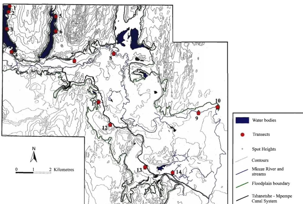
When axis 1 was plotted against axis 3 (Fig. 4.6) it is clear that the Imperata cylindrica hygrophilous grassland community (I) was distributed on clayey soils located at relatively large distances from the local thalweg. Muzi and Yengweni pans are perennial linear-formed pans that occupy shallow, north-south oriented interdune depressions north of the Mkuze River. None of the transects were longer than 100 m, indicating that the floodplain margin around these pans was extremely narrow.
The banks of both pans were slightly sloping and as one advanced from the water's edge to the land rise three bands of vegetation were visible. Shallow waters along the coast were characterized by floating aquatic vegetation described as the Potamogeton thunbergii-Ludwigia stolonifera (Aq) aquatic community (see Section 4.3.4 for full description). The second vegetation belt was typically grassy and was determined to belong to either the Echinochloa pyramidalis-Cyperus dives undisturbed backswamp community (Ea) or the Cynodon dactylon undisturbed floodplain community (C2).
Transect 5
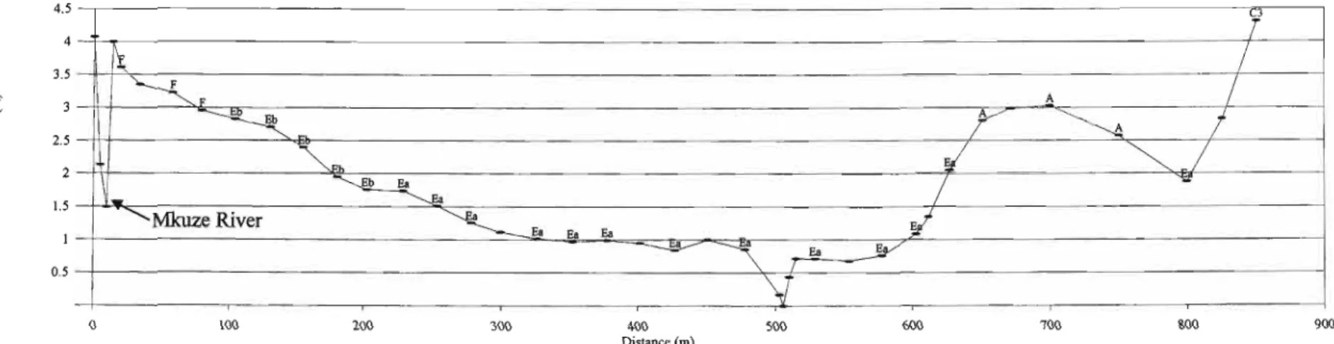
Both transects illustrate possible evidence of channel migration across this section of the lower Mkuze River floodplain. At approximately 500m along transect 7, a secondary channel was encountered; while at 400m along transect 8 a severed serpentine or oxbow lake was visible. Both of these features are surrounded by either the Eehinoeh/oa pyramidalis- Cyperus duik undisturbed backswamp community (Ea) or the Eehinoeh/oa pyramidalis- Sorghum bic%rdisturbed backswamp community (Eb).
The northern shore of oxbow lake is supported by remnant vegetation that belonged to the Fieus syeomorus riparian forest community (F). As one progressed towards the floodplain boundary elevation increased, these higher lying areas were characterized by the Aeacia xanthoph/oea (A) forest community. River channel depth decreased from 3,580 m to 2,955 m and channel width decreased slightly from 14 to 12 m as one progressed downstream from transect 7 to transect 8.
- Discussion
- Plant Community Classification and Distribution-Comparative Studies
- Environmental Determinants of Plant Community Distribution
- Conceptual Model of Vegetation-Environment Relationships
- Conclusion
The Eehinoehloa pyramidalis-Cyperus dives in the undisturbed backswamp community (Ea) were characterized by the Giant Sedge Cyperus dives, which occurred in approximately 50% of the sample sites with cover values ranging from less than 1 to 50%. Cynodon daetylon occurred in 93% of sample plots with coverage values ranging from less than 1 to more than 50%. The Cynodon dactylon moderately disturbed floodplain community (C3) was characterized by Sida cordifolia, which occurred in 74% of sample plots with cover values ranging from less than 1 to 25%.
It occurs mainly towards the distal reaches of the floodplain south of the Mkuze River. The Phragmites mauritianus community of Fumess & Breen (1980) corresponds to the Phragmites mauritianus reed swamp community (P) of the present study. However, it was widespread in the area north of the eastern edge of the floodplain, within the Mbazwane wetland (Schoultz, 2000).
CHAPTERS LANDSCAPE ECOLOGY
Introduction
Methodology
- The Spatial Distribution of Plant Community Types
- The Description of the Functional Mosaic .1 The Identification of Functional Types
- The Spatial Distribution of Functional Types
The floodplain community of Cynodon dactylon (C) is found along the southern edges of the floodplain boundary, particularly in the Ngwenya and Ngwenya Pans region. The functional type comprising the Cynodon dactylon floodplain community (C) is located in the middle to distal part of the floodplain and forms a narrow band along the southern boundary. It is usually found in the distal parts of the floodplain, which are rarely exposed to hydrological and sedimentological inputs from the Mkuze River.
This functional type is usually located in elevated, sandy areas along the southern, distal extent of the floodplain. The positions of the Mkuze River and the Tshanetshe-Mpempe canal system are labeled on each profile. The presence of this ridge-basin feature is continuous along the length of the floodplain.

Discussion
- The Spatial Distribution of Functional Types
- Floodplain Patterns and Processes
The identification and distribution of the three functional types provides a useful framework for investigating ecological processes occurring in the floodplains of the lower Mkuze River. Overbank: Flooding of the Mkuze River is the main input of water and sediment to the floodplain system. The supply of coarse-grained sediments to the floodplains does not take place via the Mkuze River.
The proximal-seasonally flooded functional type is mainly influenced by the input of water and sediment from the Mkuze River. The distal-permanently flooded functional type is influenced by a combination of water and sediment inputs from the Mkuze River as well as the south-draining Mbazwane and Manzibomvu streams. The breaching of the canal embankments was started at two points along the Mkuze River during the excavation of the Tshanetshe and Tshanetshe canals.

Conclusion
Introduction
Methodology
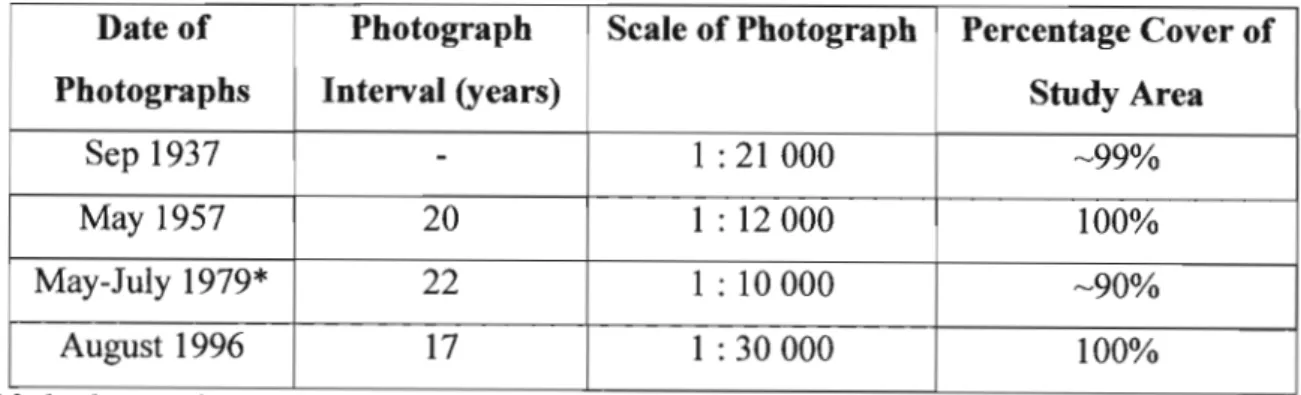
- Aerial Photograph Based Mapping
- Spatial Statistics
Spatial statistical analysis is a recognized method for quantifying and investigating the temporal change of landscape patterns (Dunn et al., 1991; Turner et al., 1991). An in-depth study of the relationship between patch marks, such as the number, size and shape of patches comprising landscape pattern, and associated ecological processes operating within the lower Mkuze River floodplain was beyond the scope of this study. Rather, landscape pattern was quantified to allow for the comparison of the floodplain landscape over the 59-year period.
The spatial statistics for the four sets of plant community distribution maps were calculated using PATCH ANALYST, an ArcView GIS extension. PATCH ANALYST consists of several scripts written in Avenue and C code, and it incorporates a modified version of Fragstat's Spatial Pattern Analysis program, commonly used for generating spatial statistics in landscape ecology studies (Elkie et al., 1999). Patch size standard deviation (PSSD) - The standard deviation of patch areas within each map category (ha).
Results
- The Description of Past Landscape Mosaics 1937
- General Patterns of Landscape Change .1 The Plant Community Landscape Mosaic
- Heterogeneity and Disturbance
- Future Changes in the Landscape Mosaic
At the reference level, the percentage contribution to the total landscape area of the distal-permanently flooded swamp, the proximal-seasonally flooded swamp and the distal-infrequently flooded floodplain is 4.5%, respectively (Table 6.3). At the plant community or grain level, the percentage contribution to the total landscape area of the riparian forest community of Ficus sycomorus is (F) ha). At the reference level, the proximal-seasonally flooded swamp, which covers 42.6% of the total landscape area (2141 ha), dominates the functional landscape mosaic (Table 6.4).
The number of agricultural field areas is 21, occupying approximately 14% of the total landscape area (~700 ha). The distal-sparsely flooded plain contributes the least to the total landscape area of the three functional types. Conversion of wetlands to cultivated fields usually involves:. l) Removal of natural vegetation, in this case mainly the riparian forest community Ficus sycomorus (F) and the back swamp community Echinochloa pyramidalis (E), leading to increased erosion.

Conclusion
These two scenarios illustrate the fact that the relationship between anthropogenic disturbance and landscape transformation is not linear and that the interpretation of the impact of anthropogenic disturbance on landscape transformation depends on the scale of observation. In a system such as the Mkuze River floodplain, where there is more than one primary land owner/user (and therefore more than one source of anthropogenic disturbance) with different needs and objectives (such as resource reliance of wetlands for livelihoods and conservation.and natural resource management) the impacts of resource use and management decisions on ecosystem patterns and processes must be continuously monitored to ensure sustainability.
CONCLUSION
- Synthesis ofthe study
The Pongola River floodplain is located in the Makatini Plains, downstream of the Pongolopoort Dam (Jozini Dam) and extends in a north-easterly direction to the confluence of the Pongolo and Usutu Rivers in the Ndumu Game Reserve (Heeg & Breen, 1982). The lower Mkuze River floodplain is relatively unmodified by humans when compared to other coastal plain floodplain systems. Alexander W.J.R 1986 Some aspects of the hydrology of the Mkuza Swamp System.)n:. eds) Proceedings of the Great Mkuza Swamp System symposium and workshop.
2002 A Preliminary Analysis of the Water Chemistry of the Mkuze Wetland System, KwaZulu-Natal: A Mass Balance Approach. 1986 The plant communities of the Mkuze swamp system. eds) Proceedings of the Greater Mkuze Swamp System symposium and workshop. 2000 The Mkuze River from the Lebombo Mountains to the lower Mkuze Bridge. ed) Maputaland: Focus on the Quaternary evolution of the south.
Sample Preparation Procedure Introduction
An empty SOOml beaker was dried in an oven at 10 SoC for about one hour, taken out of the oven, cooled and weighed. The oven-dried soil was then placed in this beaker, weighed and the mass recorded.
The Pipette Particle Size Method Introduction
The Walldey - Black Organic Matter Content Method Introduction
Percent organic matter=CO.67)(Applied volume ammonium content) Mass of oven-dried soil sample (Geographical & Environmental Sciences, 1998).
Full TWINSPAN output table (PTO)