isprsannals II 2 W1 163 2013
Teks penuh
Gambar


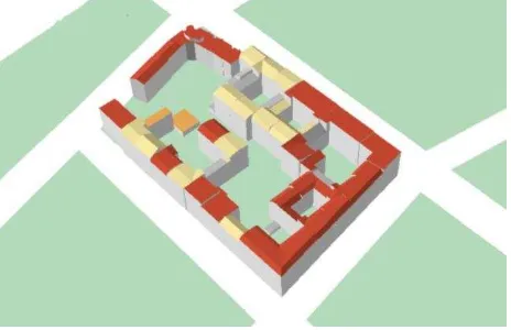
![Figure 3. 3D visualisation of coloured buildings regarding the estimated annual heating energy demand [kWh/a]](https://thumb-ap.123doks.com/thumbv2/123dok/3197676.1392162/5.595.306.541.561.715/figure-visualisation-coloured-buildings-regarding-estimated-annual-heating.webp)

Garis besar
Dokumen terkait
This approach required a planning of the recording strategies adopted by the different specialists involved in the project and the structuring of the collected data in a way that
This approach is tested and validated by the CityFlood water run-off model to confirm the idea that topographical information, mainly the boundary locations and
One of the major development efforts within the GI Science domain are pointing at sensor based information and the usage of real time information coming from geographic
By generating image tiles using this service, the 3D rendering process is shifted from the client side, which provides major advantages: (a) The complexity of the 3D city model data
Some techniques blur the same image at different scales and levels of blur using a Gaussian function; the keypoints are the points that remain as maximas at different levels of blur
(2012) have been working on the visualisation principles in 3D cadastres and investigated which variables among visual variables are appropriate for geovisualisation of
“ Intersect ” and “ Contains ” belong to the simple database services: “ Intersect ” checks whether a ISPRS Annals of the Photogrammetry, Remote Sensing and
data model which provides the possibility to share a procedural description of multi-scale models in order to transmit the dependencies between the different LoDs and which makes it
![Figure 7. Map representation of coloured buildings regarding the estimated annual electric power demand [kWh/a]](https://thumb-ap.123doks.com/thumbv2/123dok/3197676.1392162/7.595.97.253.213.306/figure-representation-coloured-buildings-regarding-estimated-annual-electric.webp)