DEVELOPMENT
ASSESSMENT UNIT
Tuesday, 25 February 2020
T O S T R I V E F O R B E T T E R T H I N G S
DEVELOPMENT ASSESSMENT UNIT MEETING 25 FEBRUARY, 2020
ITEM SUBJECT PAGE
ITEM-1 CONFIRMATION OF MINUTES 3
ITEM-2 DA 240/2020/ZA - INFILL SUBDIVISION CREATING TWO RESIDENTIAL LOTS INCLUDING DEMOLITION ACCOMPANIED BY A REQUEST TO VARY A DEVELOPMENT STANDARD (MINIMUM LOT SIZE) - LOT 11 DP 23025, 10 PRESIDENT ROAD, KELLYVILLE
5
DEVELOPMENT ASSESSMENT UNIT MEETING 25 FEBRUARY, 2020
PAGE 3 MINUTES OF THE DEVELOPMENT ASSESSMENT UNIT MEETING HELD AT THE HILLS SHIRE COUNCIL ON TUESDAY, 11 FEBRUARY 2020
PRESENT
Cameron McKenzie Group Manager – Development & Compliance (Chair) Paul Osborne Manager – Development Assessment
Benjamin Hawkins Manager – Subdivision & Development Certification Angelo Berios Manager – Environment & Health
Craig Woods Manager – Regulatory Services Nicholas Carlton Manager – Forward Planning Kristine McKenzie Principal Executive Planner APOLOGIES
Nil
TIME OF COMMENCEMENT 8:30am
TIME OF COMPLETION 8:36am
ITEM-1 CONFIRMATION OF MINUTES
RESOLUTION
The Minutes of the Development Assessment Unit Meeting of Council held on 4 February 2020 be confirmed.
ITEM-2 DA 105/2020/HA – DEMOLITION OF EXISTING STRUCTURES AND CONSTRUCTION OF A GREENHOUSE WITHIN AN EXISTING INTENSIVE PLANT AGRICULTURE DEVELOPMENT – LOT A DP 409452 AND LOT 1 DP 323277, NOS. 33-37 AND 30 BORONIA ROAD, GLENORIE
PUBLIC NOTIFICATION OF THE DETERMINATION PURSUANT TO ITEM 20(2)(c) AND (d) OF SCHEDULE 1 OF THE ENVIRONMENTAL PLANNING & ASSESSMENT ACT, 1979
DECISION:
The application be approved subject to conditions in the report.
REASONS FOR THE DECISION:
DEVELOPMENT ASSESSMENT UNIT MEETING 25 FEBRUARY, 2020
PAGE 4
Section 4.15 (EP&A Act) – Satisfactory.
LEP 2012 – Variation required, see report
DCP Part B Section 1 – Variation required, see report.
Section 7.12 Contribution: $166,800.85
HOW COMMUNITY VIEWS WERE TAKEN INTO ACCOUNT IN MAKING THE DECISION The development application was notified and no submissions were received.
END MINUTES
DEVELOPMENT ASSESSMENT UNIT MEETING 25 FEBRUARY, 2020
PAGE 5 ITEM-2 DA 240/2020/ZA - INFILL SUBDIVISION CREATING TWO RESIDENTIAL LOTS INCLUDING DEMOLITION ACCOMPANIED BY A REQUEST TO VARY A DEVELOPMENT STANDARD (MINIMUM LOT SIZE) - LOT 11 DP 23025, 10 PRESIDENT ROAD, KELLYVILLE
THEME: Valuing our Surroundings OUTCOME:
5 Well planned and liveable neighbourhoods that meets growth targets and maintains amenity.
STRATEGY:
9.3 Manage new and existing development with a robust framework of policies, plans and processes that is in accordance with community needs and expectations.
MEETING DATE:
25 FEBRUARY 2020
DEVELOPMENT ASSESSMENT UNIT
AUTHOR:
SENIOR TOWN PLANNER GANNON CUNEO
RESPONSIBLE OFFICER:
MANAGER – SUBDIVISION AND DEVELOPMENT CERTIFICATION
BEN HAWKINS
Applicant Warren Eldridge and Associates Owner Mr G Georges and Mrs G Georges Notification 21 days
Number Advised 35 Number of Submissions Two
Zoning R2 Low Density Residential
Site Area 1,265m2
List of all relevant s4.15(1)(a) matters
Section 4.15 (EP&A Act) – Satisfactory
The Hills LEP 2019 – Variation sought/ see report SEPP No 55 – Remediation of Land – Satisfactory
The Hills DCP 2012 – Part B Section 2 – Residential – Variations sought/ see report
Section 7.11 Contribution: $22,293.60 Political Donation None Disclosed
Reason for Referral to DAU 1. LEP Variation < 10%
2. DCP Variations
3. Two submissions received Recommendation Approval subject to conditions EXECUTIVE SUMMARY
The Development Application is for a subdivision creating two residential lots. The proposal includes demolition of the existing dwelling and site improvements (excluding a detached garage and shed) driveway construction and stormwater management works.
DEVELOPMENT ASSESSMENT UNIT MEETING 25 FEBRUARY, 2020
PAGE 6 The subject site is located on land zoned R2 Low Density Residential under The Hills Local Environmental Plan 2019 and is surrounded by existing single and two storey dwellings. The proposed development seeks a variation to the minimum lot size requirement under The Hills Local Environmental Plan 2019.
This development application is accompanied by a request to vary development standards under Clause 4.6 of The Hills Local Environmental Plan 2019. The minimum lot size is 700m2, it is proposed to create lots with areas of 640.8m2 and 632.9m2 respectively. This represents variations of 9.6% and 8.5% to the development standard. For reasons identified in the report it is considered the variation request can be supported as the applicant’s request is well founded, the development is consistent with zone objectives and compliance with the standard is unnecessary and unreasonable in this instance.
As a result of the variation to the minimum lot size the proposal also includes a variation to the minimum frontage and building platform requirements from The Hills Development Control Plan 2012 – Part B Section 2 – Residential.
The application was notified to 35 nearby and adjoining properties and submissions from the owners of two adjoining properties were received. The issues raised primarily relate to the non-compliance with the minimum lot size requirement, stormwater disposal, fencing, solar access, natural ventilation and visual privacy. These concerns have been addressed in the report.
The application is recommended for approval subject to conditions.
BACKGROUND
The subject site is a large, regular shaped allotment in an existing low density residential area. The immediate and wider area is predominantly characterised by single residential dwellings with some multi dwelling housing developments within the locality.
The adjoining properties to the north east (12 and 12A President Road) were subdivided in 1990. The adjoining properties to the south west (8 and 8A President Road) were subdivided in 2001. A pre-lodgement meeting was held on 22 January 2019 proposing a subdivision creating two residential lots and including demolition.
PROPOSAL
The Development Application is for the subdivision of one existing residential lot into two residential lots. The proposal includes the following works:
Demolition of existing structures on the site including a single storey dwelling and a shed. An existing brick garage and metal garden shed will be retained towards the rear of lot 112.
Removal of one street tree; and
Civil works including construction of a vehicular crossing to proposed lot 111 including minor earthworks in the road reserve to achieve appropriate levels in the footpath.
DEVELOPMENT ASSESSMENT UNIT MEETING 25 FEBRUARY, 2020
PAGE 7 The site slopes to the street. Stormwater works (including the need for onsite stormwater detention for lot 111) will be undertaken with the future development of each lot. Access to each of the lots will be via President Road.
ISSUES FOR CONSIDERATION
1. State Environmental Planning Policy No 55 – Remediation of Land
State Environmental Planning Policy No 55 – Remediation of Land contains guidelines and prescriptive measures with regard to site contamination and remediation requirements for all land-based development across the State. In considering a development application for new development, the consent authority is to have regard for the prescriptive requirements of Clause 7 of the SEPP provided below:
(1) A consent authority must not consent to the carrying out of any development on land unless:
(a) it has considered whether the land is contaminated, and
(b) if the land is contaminated, it is satisfied that the land is suitable in its contaminated state (or will be suitable, after remediation) for the purpose for which the development is proposed to be carried out, and
(c) if the land requires remediation to be made suitable for the purpose for which the development is proposed to be carried out, it is satisfied that the land will be remediated before the land is used for that purpose.
The contamination status of the subject site has been considered with the proposed subdivision. A Site Contamination Investigation Report prepared by Bill Ho Denistone and Associates (dated 19 August 2019) was submitted with the application and concluded the likelihood of contamination is low. The recommendations of the report suggest testing of the footprint of structures on the site once they are demolished.
Council’s Environmental Health Team has reviewed the application and documents and is satisfied with the proposal subject to the imposition of conditions.
2. Compliance with The Hills Local Environmental Plan 2019 (i) Permissibility
The land is zoned R2 Low Density Residential under The Hills Local Environmental Plan 2019 (LEP). The proposed development is defined as subdivision. Subdivision is permissible with consent under Clause 2.6 of the LEP.
(ii) Zone Objectives
The objectives of the R2 zone are:
To provide for the housing needs of the community within a low density residential environment.
To enable other land uses that provides facilities or services to meet the day to day needs of residents.
To maintain the existing low density residential character of the area.
DEVELOPMENT ASSESSMENT UNIT MEETING 25 FEBRUARY, 2020
PAGE 8 The proposal is consistent with the stated objectives of the zone, particularly in that the proposal will provide opportunities for the orderly development of land in a low density residential environment. The proposal includes the creation of two vacant residential lots for future development. The proposal is therefore considered to provide a balanced outcome for development of the site and provides for the housing needs of a growing community in a low density residential environment.
(iii) Development Standards
The following addresses the principal development standards of the LEP relevant to the subject proposal:
Clause 2.6 Subdivision – consent requirements
Clause 2.6 of the LEP requires that development consent be sought for subdivision of land to which this clause applies. The Development Application seeks consent for subdivision and therefore complies with this requirement of the LEP.
Clause 4.1 Minimum subdivision lot size
The subject site is located on land identified on the Lot Size Map under Clause 4.1 of the LEP. In accordance with the requirements of Clause 4.1, the size of any lot resulting from a subdivision of land is not to be less than the minimum size shown on the Lot Size Map. The minimum size shown on the Lot Size Map for the subject site is 700m2.
The proposed development seeks to create two residential lots which are identified as having an area of 640.8m2 for lot 112 and 632.9m2 for lot 111 which also does not comply with the requirements of Clause 4.1.
The non-compliance with the minimum lot size requirement is discussed in further detail under the Clause 4.6 section of this report.
Clause 4.6 Exceptions to development standards
Clause 4.6 provides the mechanism for a development standard to be varied where it is considered unreasonable or unnecessary in the specific circumstances of the case and where there are sufficient environmental planning grounds to justify the variation. The objectives are stated in Clause 4.6(1):
(a) To provide an appropriate degree of flexibility in applying certain development standards to particular development,
(b) To achieve better outcomes for and from development by allowing flexibility in particular circumstances.
Further, Clause 4.6(3) states that:
Development consent must not be granted for development that contravenes a development standard unless the consent authority has considered a written request from the applicant that seeks to justify the contravention of the development standard by demonstrating:
DEVELOPMENT ASSESSMENT UNIT MEETING 25 FEBRUARY, 2020
PAGE 9 (a) that compliance with the development standard is unreasonable or
unnecessary in the circumstances of the case, and
(b) that there are sufficient environmental planning grounds to justify contravening the development standard.
Applicant’s Submission under Clause 4.6
The applicant has submitted a written request that seeks to justify the contravention of the development standard (refer Attachment 8). The applicant’s justification in response to Clause 4.6(3) points (a) and (b) is summarised as follows:
(a) It is considered that strict compliance with the standard would be unreasonable or unnecessary in the circumstances of the case:
The proposed lots are capable of proper and orderly residential development of the land. The proposed lot areas are 640.8 sqm (Lot 112) and 632.9 sqm (Lot 111). The lot width is 15.24 m and lot depth varies between 41 to 42 metres. The proposed lots are considered to have size and dimension that will readily allow for the construction of dwelling houses similar to those seen on adjoining properties and within the surrounding locality.
It is noted that the subject land is adjoined by parcels of land that have already been subdivided in a manner similar to that being proposed. Adjoining to the west of the subject land is No. 8 and 8A President Road each having a lot area of 572.3 sqm and 564.6 sqm respectively. Similarly, adjoining to the east of the subject land is 12 and 12A president Road with both of these lots having an area of around 624.7 sqm and 606.5 sqm. These existing lots are smaller than the statutory minimum lot standard of 700 sqm and smaller than the proposed lots in this subdivision.
Furthermore, the proposed allotment widths of 15.24 metres for each lot is consistent with the width of the adjoining lots and the prevailing subdivision of residential lots fronting President Road between Sheila Pace and Greenwood Street being 15.24 metre wide lots.
The proposed lots provide for building platforms with a dimension of 13.25 x 20 metres or 265 sqm. The building platform could be extended further to the rear of each lot if necessary. It is noted that most project homes, readily seen throughout Kellyville and The Hills District, are designed for lot widths of 15 metres and building platforms consistent with those proposed.
The setback of the proposed building platforms from President Road vary between 8.7 to 9.7 metres, consistent with the predominant alignment of adjoining development and allowing for generous landscaping at the street frontage.
The setback of the proposed building platforms to the rear boundary is between 9m to 10 m and over 135 sqm in area, well in excess of minimum requirements, and providing generous north facing rear yard areas.
It is considered that the proposed lots will be capable of supporting a future dwelling which, in terms of bulk, scale, height, site coverage and the like, will be compatible with other properties zoned R2 Residential Low Density along the northern side of President Road, Kellyville.
DEVELOPMENT ASSESSMENT UNIT MEETING 25 FEBRUARY, 2020
PAGE 10
The proposed lots will not lead to the fragmentation or isolation of land. The lots will have a similar frontage and access to President Road as other adjoining and existing allotments.
It is noted that the site is located within an area with varying residential built form, include single storey and two storey dwelling houses and two storey townhouse development. It is noted that there is R3 Medium Density residential development on the opposite side of President Road, a local preschool and the site is within easy walking distance of commercially zoned land uses fronting Windsor Road at Kellyville. The site is well served by public transport and is highly accessible to the regional road network. The prevailing character of the area includes low to medium residential density development. The proposal is consistent with the character of surrounding land.
Furthermore, the existing large allotment is out of character with the prevailing subdivision pattern. Of the 16 lots within the R2 zone within close proximity to the subject land, 50% of these lots have areas less than the 700sqm (the prescribed minimum lot size). The existing site being 1,273 sqm in area is bounded on all three sides by allotments less than 700 sqm, and could be described as the “odd man out”.
It is considered that the proposed residential subdivision of the land is consistent with the objectives of the R2 Low Density zone as outlined above. The proposed subdivision improves the housing needs of the community within a low density residential environment.
Approval for the residential subdivision and development of land adjoining the subject site has previously been given by The Hills Council for similar development in the same zoning.
The subdivision is clearly within the land environmental capacity and will maintain a development on site which is compatible with a low density residential environment.
The proposed residential subdivision will maintain the existing low density character of the area. It is considered that the minor numerical non-compliance will not affect the development’s overall ability to satisfy the objectives of the zoning of the land.
(b) That there are sufficient environmental planning grounds to justify contravening the development standard:
It is noted that the variation to the numerical development standard is less than 10%
for each of the proposed allotments. The proposal allows for the residential subdivision consistent with the environmental capacity of the land and compatible with existing adjoining residential development with no material adverse environmental or amenity impact.
Further, the proposal also has benefits in broader environmental terms by allowing the orderly and efficient development of the land, consistent with the desired future character of the locality. The proposed lots will result in the orderly and economic use and development of urban land that is generally consistent with what is envisaged in the planning controls for the R2 Zone in this location.
DEVELOPMENT ASSESSMENT UNIT MEETING 25 FEBRUARY, 2020
PAGE 11
Instead of maintaining a large underutilized parcel of residential land that is inconsistent with the prevailing character of the area, it is considered appropriate to optimise the development of R2 zoned land in a manner compatible with both adjoining development and consistent with the overall form of development in an area which is located close to a wide range of goods and services and public transport. This proximity provides appropriate convenience for future residents, with no material adverse impact on the residential amenity of adjoining land or character of surrounding development.
It would be unreasonable to prohibit redevelopment of the site as proposed, simply because the site’s lot size did not strictly meet the minimum lot size required for the zone. The planning controls allow a suitable predominantly low density residential development. The lot size, width and indicative building footprint conforms with that normally required for low density residential housing throughout The Hills and surrounding local government areas.
The consent authority must also be satisfied that the proposal meets the objectives of the standard and the objectives of the subject zone. As assessed [in an earlier section], the proposal meets the objectives of the clause 4.1 minimum lot size and meets the objectives of the R2 Low Density Zone.
Assessment under Clause 4.6 Clause 4.6(4) specifies:
Development consent must not be granted for development that contravenes a development standard unless:
(a) the consent authority is satisfied that:
(i) the applicant’s written request has adequately addressed the matters required to be demonstrated by subclause (3), and
(ii) the proposed development will be in the public interest because it is consistent with the objectives of the particular standard and the objectives for development within the zone in which the development is proposed to be carried out, and
(b) the concurrence of the Secretary has been obtained.
In regards to (a)(i), the Applicant’s written request has adequately addressed the matters required to be demonstrated by subclause (3) for the following reasons:
(3)(a) It is considered that strict compliance with the standard would be unreasonable or unnecessary in the circumstances of the case, and
(3)(b) That there are sufficient environmental planning grounds to justify contravening the development standard:
Reference is made in the Clause 4.6 request to two judgements in the NSW Land and Environment Court. The two cases outlined below are used as the basis for seeking a variation to the minimum lot size requirement:
Firstly, Wehbe v. Pittwater Council [2007] NSWLEC 827 establishes a number of ways in which the applicant might establish that compliance with a development standard is unreasonable or unnecessary, namely that:
DEVELOPMENT ASSESSMENT UNIT MEETING 25 FEBRUARY, 2020
PAGE 12 1. The objectives of the standard are achieved notwithstanding non-compliance with
the standard;
2. The underlying objective or purpose of the standard is not relevant to the development and therefore compliance is unnecessary;
3. The underlying object of purpose would be defeated or thwarted if compliance was required and therefore compliance is unreasonable;
4. The development standard has been virtually abandoned or destroyed by the Council's own actions in granting consents departing from the standard and hence compliance with the standard is unnecessary and unreasonable.
5. The zoning of the particular land is unreasonable or inappropriate so that a development standard appropriate for that zoning is also unreasonable and unnecessary as it applies to the land and compliance with the standard would be unreasonable or unnecessary. That is, the particular parcel of land should not have been included in the particular zone.
Whilst Webhe was a decision of the Court dealing with SEPP 1, it has been also found to be applicable in the consideration and assessment of Clause 4.6.
Secondly, Four2Five v Ashfield Council [2015) NSWLEC 1009 established that Clause 4.6(3)(b) requires an applicant for development consent to show that environmental planning grounds exist particular to the circumstances of the proposed development on the subject site, to justify contravening the development standard.
This finding was upheld by Pain,J in the subsequent appeal Four2Five v Ashfield Council [2015) NSWLEC 90.
The Applicant in their statement refers to “subject land is adjoined by parcels of land that have already been subdivided in a manner similar to that being proposed”.
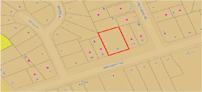
Figure 1 below identifies the Torrens title lots in the vicinity of the subject site below 700m2 (shown by purple dots). The lots surrounding the subject site that are below the minimum lot size range in area between 360.4m2 and 646.8m2. One lot shown in Figure 1 has an area of 107.5m2; however this lot has not been considered in this assessment.
Figure 1: LEP Minimum Lot Size Mapping
DEVELOPMENT ASSESSMENT UNIT MEETING 25 FEBRUARY, 2020
PAGE 13
The Applicant has undertaken a comparative analysis which illustrates that the proposed subdivision would not be without precedent. The following properties are addressed:
No. 8A President Road – 572.3m2 with a frontage of 15.24 metres;
No. 8 President Road – 564.6m2 with a frontage of 15.24 metres;
No. 12A President Road – 624.7m2 with a frontage of 15.24 metres; and
No. 12 President Road – 606.6m2 with a frontage of 10.69m (this is a corner lot and the actual width of the lot is 15.24 metres).
The proposal seeks to subdivide 10 President Road creating the following:
Proposed lot 110 with an area of 640.8m2 and a frontage of 15.25 metres; and
Proposed lot 111 with an area of 632.9m2 and a frontage of 15.25 metres.
The variation sought for lot 110 represents a variation of 8.4% to the minimum lot size requirement. The variation sought for lot 111 represents a variation of 9.5% to the minimum lot size requirement. The proposed variation is considered minor in the context of the site where the four directly adjoining lots will have the same frontage and a smaller area than each lot within the proposed subdivision.
With respect to the objectives of the R2 Low Density Residential zone of the LEP, the following comments are provided:
To provide for the housing needs of the community within a low density residential environment.
The proposal seeks to create an additional lot within the R2 Low Density Residential Zone. The future development/ use of the site is limited to those permitted with or without consent as outlined in the Land Use Table in the LEP. This is consistent with the existing lot and the adjoining properties.
To enable other land uses that provide facilities or services to meet the day to day needs of residents.
The development of the proposed lots beyond residential use is subject to future application/s being lodged with the relevant consent authority for assessment. This application provides greater opportunities for land to be developed to meet the needs of residents.
To maintain the existing low density residential character of the area.
The future development of the proposed residential lots is subject to the requirements of the Land Use Table in the LEP. The permissible uses/ developments in the R2 zone aim to maintain a low density character. The variation to the minimum lot size requirement maintains the existing low density character of the area and does not provide any intensification of development beyond the creation of an additional single residential allotment.
As outlined above, the proposal meets the objectives of the R2 Low Density Zone.
More broadly, the proposal is considered to meet the objectives of Clause 4.1 of the LEP Minimum Subdivision Lot Size; specifically, objective (c) “to ensure that the prevailing character of the surrounding area is maintained”. The surrounding area is
DEVELOPMENT ASSESSMENT UNIT MEETING 25 FEBRUARY, 2020
PAGE 14 characterised by smaller allotments than the subject site which are below the minimum lot size. As outlined earlier in this report, there is a concentration of allotments below the minimum lot size directly adjoining the subject site. The proposed subdivision would result in an additional residential lot which is consistent with the character of the immediate and surrounding area.
Refusal of the application would result in a single large residential lot sterilised by adjoining properties which have been subdivided prior to the current legislated minimum lot size requirement. The lot being retained in its current state could be seen as out of character for the area.
In regards to Clause 4.6(4)(b), Planning Circular PS 18-003 issued 21 February 2018 gives assumed concurrence from the Secretary to Independent Hearing and Assessment Panels.
3. The Hills Development Control Plan 20122
The proposal has been assessed against the provisions of The Hills Development Control Plan 2012 – Part B Section 2 – Residential (DCP). The proposed development is generally compliant with the relevant requirements of the DCP with the exception of the variations listed below:
DEVELOPMENT CONTROL PROPOSED DEVELOPMENT
COMPLIANCE 2.13.1(b) Minimum frontage
requirement – 18 metres
Lot 110 and 111 have a frontage of 15.25 metres each.
Variation (see report)
2.13.2(a) Minimum building platform – 20m x 15m
As a result of the width of each lot, the building platform requirement is unable to be achieved.
A building platform has been identified on lot 110 and a potential dwelling floor plan from a project home builder has been provided on lot 111. The dimensions for each do not meet the minimum requirement under the DCP.
Variation (see report)
2.13.1(b) Minimum frontage
The DCP stipulates that lots created as a result of the subdivision of land are to have a frontage of at least 18 metres. The proposed lots in the subdivision have a frontage of 15.25 metres each which is 2.75 metres short of the minimum required.
The objectives of this section of the DCP are to provide allotments of a size conducive to residential living, having regard to any development constraints or environmental qualities of that land and to ensure allotments have sufficient area to provide adequate access, open space, a sufficient building platform and attractive presentation to the street. The proposed
DEVELOPMENT ASSESSMENT UNIT MEETING 25 FEBRUARY, 2020
PAGE 15 subdivision has provided a building platform and potential dwelling design for each lot (refer Attachment 5) which demonstrates that regardless of the variation to the minimum frontage requirement, each lot is capable of achieving the objectives of this requirement and the overall intent of the control.
Whilst each lot is unable to achieve the minimum frontage requirement, the proposal has suitable demonstrated that each lot is capable of having a dwelling constructed with compliant setbacks. The variation to the minimum frontage requirement is considered minor (15.3%) and is supported in this instance.
2.13.2(a) Minimum building platform
The proposal includes a minor variation to the building platform for the proposed lots within the subdivision. The DCP requires that a nominal building platform of 20 metres by 15 metres be identified with complying boundary setbacks. The platform identified on proposed lot 110 provides a dimension of 22.32 metres in depth and 13.44 metres in width. Whilst the platform is 1.56 metres below the minimum width requirement, the depth exceeds the minimum of 20 metres by 2.32 metres whilst still providing for a rear setback of 9.6 metres which exceeds the rear setback requirement of 4 metres to the ground floor and 6 metres to the first floor. In addition, the area provided for the potential building platform is equal to that of a building platform with compliant dimensions, being 300m2.
To further support the proposed variation to the building platform requirement, the applicant has provided an indicative dwelling footprint by a project home building on proposed lot 111 which demonstrates a potentially compliant dwelling (refer Attachment 5). The dwelling does not form part of the proposal and was only provided to support the proposal to create the vacant lots.
Whilst the proposal includes a variation to the dimensions of the building platform, the application has demonstrated that a dwelling can be constructed on each lot within the proposed building platform which satisfies the overall objective of the building platform requirement. The building platform is not required to be registered as a restriction on the title of either of the proposed lots. The proposed variation is supported in this instance.
4. Issues Raised in Submissions
The proposal was notified for 21 days. Two submissions were received. The issues raised in the submissions are summarised below:
ISSUE/ OBJECTION COMMENT
Concern is raised stating the westerly sunlight will be limited requiring the increased use of heaters and air- conditioning which will impact the environment through noise and power use. They will also be burdened with the extra cost.
The proposal is for subdivision only. The applicant has provided a potential floor plan of a single storey dwelling, similar to the adjoining properties, which will not adversely impact solar access to adjoining properties.
Further, solar access to the adjoining property in question would only be slightly impacted in the afternoon. The proposed lots and adjoining properties would still be able to achieve compliant solar access.
This matter can be more properly considered with a future application (either as a Development Application or a Complying Development Certificate application) on one or both of the proposed lots.
DEVELOPMENT ASSESSMENT UNIT MEETING 25 FEBRUARY, 2020
PAGE 16
ISSUE/ OBJECTION COMMENT
Concern is raised stating airflow will be affected and as a result an increased use of air-conditioning in summer, which will impact the environment through noise and power use.
The proposed subdivision will not impede natural airflow through the subject site. There are only minor physical works involved with the proposal.
Concern is raised stating all the bedrooms are along the westerly edge of the adjoining house. The subdivision will create a dwelling 2 metres from bedrooms of the residents of the existing adjoining dwelling. Our privacy as we know it will no longer exist.
The DCP requires a minimum side setback of 900mm for dwellings from the side boundary which would provide a total of 1.8 metres.
The dwelling on the adjoining property is approximately 1.5 metres from the side boundary and the plans submitted with the application show a future dwelling potentially setback 1.5 metres from the side boundary, providing for a total of 3 metres. The proposed subdivision is unlikely to result in any significant adverse impacts on visual and acoustic privacy.
This matter can be more properly considered with a future application (either as a Development Application or a Complying Development Certificate application) on one or both of the proposed lots.
Concern is raised that the proposal is not in accordance with the objectives of the zone.
The objectives of the zone have been addressed earlier in this report. The proposal provides an additional residential lot which is consistent with the existing character of the area. The permissible uses in the R2 Low Density Residential zone limit the use primarily to low density residential development as the zone suggests.
Concern is raised with a number of points in the document ‘Request for a Variation to Development Standards’ prepared by David Winley of Ingham Planning. The concerns are summarised below:
The LEP makes no reference to a percentage based variation and a decision should not be made on this basis;
The case Wehbe v. Pittwater Council [2007] NSWLEC 827 is not relevant to the proposed development;
Development Application 2012/2018/ZB at 20 Evans Road, Glenhaven, is an example of a similar application which was not supported by Council;
The applicant has submitted a revised request to vary the minimum lot size under Clause 4.6 of the LEP. A number of principles in the NSW Land and Environment Court have been addressed. Whilst these cases do not relate specifically to subdivision in a low density residential zone, the commissioner/ judge has tested the requirements of Clause 4.6 against the relevant principles.
The Development Application at 20 Evans Road, Glenhaven, was refused on the basis it did not meet the objectives of Clause 4.1 of the LEP, was inconsistent with the existing character of the area and did not satisfy the requirements of the DCP. As discussed throughout this report, the two applications are different when considering the reasons for refusal of that other example.
DEVELOPMENT ASSESSMENT UNIT MEETING 25 FEBRUARY, 2020
PAGE 17
ISSUE/ OBJECTION COMMENT
The objector provides a response to the five points used to justify the contravention to the development standard (as outlined in Four2Five v Ashfield Council [2015) NSWLEC 1009) which are not considered to address the relevant points.
The five points outlined in the letter requesting the variation are addressed in the Clause 4.6 section of this report above.
Concern is raised in relation to the surveyor accessing the adjoining property to undertake survey work without the permission of the property owner. The information used in the preparation of the application should be disregarded as it was created based on unsubstantiated information.
The survey plan submitted with the development application shows spot levels for structures on the adjoining lots on either side.
This is a civil matter. The survey is dated 27 April 2019 which was prior to the Development Application being lodged with Council on 27 August 2019. The survey information submitted was prepared by a registered surveyor and is able to be relied upon for the purposes of assessing the Development Application.
Concern is raised with the impact of stormwater run-off and the adjoining property to the rear.
The subject site has a slope to the street. The natural fall of the land would result in stormwater draining to President Road.
Further, one of the two lots will require Onsite Stormwater Detention in line with Council’s adopted policy concerning the same for new developments, which has been conditioned below. It is anticipated any impacts from stormwater runoff will be negligible, especially to the rear of the site.
Concern is raised that the proposal does not meet the minimum lot size.
This matter is addressed by the applicant lodging a request to vary the affected development standard under Clause 4.6 of the LEP. This is discussed in further detail earlier in this report.
Concern is raised that the current legislation applies and land subdivided previously was under previous legislation.
Whilst it is understood the adjoining properties relied upon by the applicant in their justification (which are below the minimum lot size requirement) were approved under previous legislation; the test that is relied upon is the impact that the variation will have on the existing character of the area. The adjoining properties are below the minimum lot size currently required and also have a frontage equal to or less than the frontages proposed under the subject application; which establishes the existing character upon which this Development Application is considered against.
DEVELOPMENT ASSESSMENT UNIT MEETING 25 FEBRUARY, 2020
PAGE 18
ISSUE/ OBJECTION COMMENT
Concern is raised that the person making the objection would have preferred a friendly discussion regarding fencing and stormwater.
This is a private matter between two parties.
Council has no ability or obligation to require applicants speak to their neighbours before lodging a Development Application.
5. Internal Referrals
The application was referred to following sections of Council:
Engineering
Environmental Health
Tree Management
Resource Recovery
Traffic
No objection was raised to the proposal subject to conditions.
CONCLUSION
The Development Application has been assessed against the relevant heads of consideration under Section 4.15 of the Environmental Planning and Assessment Act 1979, The Hills Local Environmental Plan 2019 and The Hills Development Control Plan 2012 and is considered satisfactory despite the variations proposed to both. The Clause 4.6 variation submitted with respect to the Minimum Lot Size non-compliance is considered well founded and correctly constructed. The issues raised in the submissions have been addressed in the report and do not warrant refusal of the application.
Approval is recommended subject to conditions.
IMPACTS Financial
This matter has no direct financial impact upon Council's adopted budget or forward estimates.
Developer Contributions
The Hills Section 7.11 Contributions Plan No 8 – Kellyville Rouse Hill applies to the subject site. A condition is recommended requiring payment of a contribution of $22,293.60 for the creation of the additional lot which is in accordance with Contributions Plan No 8.
The Hills Future Community Strategic Plan
The proposed development is consistent with the planning principles, vision and objectives outlined within “Hills 2026 – Looking Towards the Future” as the proposed development provides for satisfactory urban growth without adverse environmental or social amenity impacts and ensures a consistent built form is provided with respect to the streetscape and general locality.
DEVELOPMENT ASSESSMENT UNIT MEETING 25 FEBRUARY, 2020
PAGE 19 RECOMMENDATION
Approval is recommended subject to the following conditions of consent.
GENERAL MATTERS 1. Approved Plan
The subdivision must be carried out in accordance with the approved plan of subdivision and demolition plan prepared by Warren Eldridge Plan Number 2932-1 dated 12/09/2019 and other supporting documentation submitted with the development application except where amended by other conditions of consent.
2. Subdivision Certificate Preliminary Review
Prior to the submission of a Subdivision Certificate application a draft copy of the final plan, administration sheet and Section 88B instrument (where included) must be submitted in order to establish that all conditions have been complied with.
Street addresses for the lots within this subdivision will be allocated as part of this preliminary check process, for inclusion on the administration sheet.
3. Demolition Notification
Both Council and any adjoining properties must be notified in writing five days before demolition works commence.
4. Demolition Inspections (Subdivision Applications)
Before demolition works commence a pre-demolition inspection must be arranged with Council’s Construction Engineer. All conditions required to be addressed before works commence must be satisfied. Once demolition works are complete, a post demolition inspection must be arranged with Council’s Construction Engineer.
5. Imported ‘Waste Derived’ Fill Material
The only waste derived fill material that may be received at the development site is:
Virgin excavated natural material (within the meaning of the Protection of the Environment Operations Act 1997); or
Any other waste-derived material the subject of a resource recovery exemption under clause 93 of the Protection of the Environment Operations (Waste) Regulation 2014 that is permitted to be used as fill material.
Any waste-derived material the subject of a resource recovery exemption received at the development site must be accompanied by documentation as to the material’s compliance with the exemption conditions and must be provided to the Principal Certifier on request.
6. Contamination
Any new information, that may come to light during construction works, which has the potential to alter previous conclusions about site contamination, shall be immediately notified to Council’s Manager – Environment and Health.
7. Adherence to Waste Management Plan
All requirements of the Waste Management Plan submitted as part of the Development Application must be implemented except where contrary to other conditions of consent. The information submitted regarding construction and demolition wastes can change provided that the same or a greater level of reuse and recycling is achieved as detailed in the plan.
Any material moved offsite is to be transported in accordance with the requirements of the Protection of the Environment Operations Act 1997 and only to a place that can lawfully be used as a waste facility. Receipts of all waste/ recycling tipping must be kept onsite at all times and produced in a legible form to any authorised officer of the Council who asks to see them.
DEVELOPMENT ASSESSMENT UNIT MEETING 25 FEBRUARY, 2020
PAGE 20 Transporters of asbestos waste (of any load over 100kg of asbestos waste or 10 square metres or more of asbestos sheeting) must provide information to the NSW EPA regarding the movement of waste using their WasteLocate online reporting tool:
www.wastelocate.epa.nsw.gov.au 8. Management of Demolition Waste
Waste materials must be appropriately stored and secured within a designated waste area onsite at all times, prior to its reuse onsite or being sent offsite. This includes waste materials such as paper and containers which must not litter the site or leave the site onto neighbouring public or private property. A separate dedicated bin must be provided onsite by the builder for the disposal of waste materials such as paper, containers and food scraps generated by all workers. Building waste containers are not permitted to be placed on public property at any time unless a separate application is approved by Council to locate a building waste container in a public place.
Any material moved offsite is to be transported in accordance with the requirements of the Protection of the Environment Operations Act 1997 and only to a place that can lawfully be used as a waste facility. The separation and recycling of the following waste materials is required: metals, timber, masonry products and clean waste plasterboard. This can be achieved by source separation onsite, that is, a bin for metal waste, a bin for timber, a bin for bricks and so on. Alternatively, mixed waste may be stored in one or more bins and sent to a waste contractor or transfer/ sorting station that will sort the waste on their premises for recycling. Receipts of all waste/ recycling tipping must be kept onsite at all times and produced in a legible form to any authorised officer of the Council who asks to see them.
Transporters of asbestos waste (of any load over 100kg of asbestos waste or 10 square metres or more of asbestos sheeting) must provide information to the NSW EPA regarding the movement of waste using their WasteLocate online reporting tool:
www.wastelocate.epa.nsw.gov.au
9. Disposal of Surplus Excavated Material
The disposal of surplus excavated material, other than to a licenced waste facility, is not permitted without the previous written approval of Council prior to works commencing on site. Any unauthorized disposal of waste, which includes excavated material, is a breach of the Protection of the Environment Operations Act 1997 and subject to substantial penalties. Receipts of all waste/ recycling tipping must be kept onsite at all times and produced in a legible form to any authorised officer of the Council who asks to see them.
10. Provision of Domestic Waste Storage Areas
A bin storage area sized for a minimum of 3 x 240 litre bins must be provided within the lot boundaries. The areas must be screened from view from public land and neighbouring residential property and are to be located behind the building line in the rear courtyard, side access path or a dedicated area in the garage. A flat or ramped bin transfer path must be provided leading directly from the bin storage areas to the approved bin collection point along the kerbside. The path must have a minimum clear floor width of 820mm, must not exceed a grade of 7% (1:14), be free of steps and must be external to the dwelling (excludes garage). An associated clear nature strip length of 1.66m must be dedicated along the kerbside for each dwelling for bin presentation. The dimensions of a 240 litre bin are 735mm deep, 580mm wide and 1080mm high.
11. Minor Engineering Works
The design and construction of the engineering works listed below must be provided for in accordance with Council’s Design Guidelines Subdivisions/ Developments and Works Specifications Subdivisions/ Developments.
Works on existing public roads or any other land under the care and control of Council must be approved and inspected by Council in accordance with the Roads Act 1993 or the Local
DEVELOPMENT ASSESSMENT UNIT MEETING 25 FEBRUARY, 2020
PAGE 21 Government Act 1993. A separate minor engineering works application and inspection fee is payable as per Council’s Schedule of Fees and Charges.
a) Driveway Requirements
The design, finish, gradient and location of all driveway crossings must comply with the above documents and Council’s Driveway Specifications.
The proposed driveway/s must be built to Council’s residential standard.
The driveway must be a minimum of 3 metres, a maximum of 5.4 metres wide at the kerb and can splay out to a maximum of 1 metre on either side at the boundary.
On high level sites a grated drain must be provided on the driveway at the property boundary.
Specifically, unless additional driveway crossings are clearly shown on the approved plans, only one driveway crossing is approved/ permitted.
A separate vehicular crossing request fee is payable as per Council’s Schedule of Fees and Charges.
b) Disused Layback/ Driveway Removal
All disused laybacks and driveways must be removed and replaced with kerb and gutter together with the restoration and turfing of the adjoining footpath verge area. Specifically, this includes the removal of any existing laybacks, regardless of whether they were in use beforehand or not.
c) Footpath Verge Formation
The grading, trimming, topsoiling and turfing of the footpath verge fronting the development site is required to ensure a gradient between 2% and 4% falling from the boundary to the top of kerb is provided. This work must include the construction of any retaining walls necessary to ensure complying grades within the footpath verge area. All retaining walls and associated footings must be contained wholly within the subject site. Any necessary adjustment or relocation of services is also required, to the requirements of the relevant service authority.
All service pits and lids must match the finished surface level.
d) Site Stormwater Drainage
The entire site area must be graded, collected and drained by pits and pipes to a suitable point of legal discharge.
12. Recycled Water – Rouse Hill/ Sydney Water
The subject site must be connected to Sydney Water’s Rouse Hill Recycled Water Scheme, unless written evidence from Sydney Water is submitted advising that this service is not available.
13. Tree Removal
Approval is granted for the removal of Tree 12 on the site survey plan prepared by (Warren Eldridge dated 12/09/2019 Plan No 2932-1).
All other trees are to remain and are to be protected during all works. Suitable replacement trees are to be planted upon completion of construction.
14. Replacement Planting Requirements
To maintain the treed environment of the Shire one advanced (25 litres) replacement tree from the following list are to be planted elsewhere within the property.
Backhousia mrytifolia Grey Myrtle Elaeocarpus reticulatus Blueberry Ash
Tristaniopsis laurina Water Gum
DEVELOPMENT ASSESSMENT UNIT MEETING 25 FEBRUARY, 2020
PAGE 22 PRIOR TO THE ISSUE OF A SUBDIVISION WORKS CERTIFICATE
15. Tree Removal on Public Land
Prior to the issue of a Subdivision Works Certificate, the applicant is required to contact Council’s Infrastructure and Works team to coordinate the removal of Tree 12 that is located on the Council Nature strip which will be impacted by works associated with the development. All tree removal must be undertaken by the owner/ applicant in accordance with the requirements of Council’s Infrastructure and Works team.
16. Security Bond Requirements
A security bond may be submitted in lieu of a cash bond. The security bond must:
Be in favour of The Hills Shire Council;
Be issued by a financial institution or other accredited underwriter approved by, and in a format acceptable to, Council (for example, a bank guarantee or unconditional insurance undertaking);
Have no expiry date;
Reference the development application, condition and matter to which it relates;
Be equal to the amount required to be paid in accordance with the relevant condition;
Be itemised, if a single security bond is used for multiple items.
Should Council need to uplift the security bond, notice in writing will be forwarded to the applicant 14 days prior.
17. Erosion and Sediment Control Plan
The detailed design must be accompanied by an Erosion and Sediment Control Plan (ESCP) prepared in accordance with the Blue Book and Council’s Works Specification Subdivision/ Developments.
An ESCP must include the following standard measures along with notes relating to stabilisation and maintenance:
• Sediment fencing.
• Barrier fencing and no-go zones.
• Stabilised access.
• Waste receptacles.
• Stockpile site/s.
PRIOR TO WORK COMMENCING ON THE SITE 18. Protection of Existing Trees
The trees that are to be retained (including trees on the Council Nature Strip) are to be protected during all works strictly in accordance with AS4970- 2009 Protection of Trees on Development Sites.
At a minimum a 1.8m high chain-wire fence is to be erected at least three (3) metres from the base of each tree and is to be in place prior to works commencing to restrict the following occurring:
Stockpiling of materials within the root protection zone.
Placement of fill within the root protection zone.
Parking of vehicles within the root protection zone.
Compaction of soil within the root protection zone.
All areas within the root protection zone are to be mulched with composted leaf mulch to a depth of not less than 100mm. A sign is to be erected indicating the trees are protected. The installation of services within the root protection zone is not to be undertaken without prior consent from Council.
DEVELOPMENT ASSESSMENT UNIT MEETING 25 FEBRUARY, 2020
PAGE 23 19. Builder and Principal Certifiers Details
The builders name, address, telephone and fax numbers must be submitted to the Principal Certifier before building works commence. Where Council is not the Principal Certifier, Council must be notified of the Principal Certifier in writing two days before building works commence in accordance with the Regulations.
20. Demolition Works and Asbestos Management
The demolition of any structure is to be carried out in accordance with the Work Health and Safety Act 2011. All vehicles transporting demolition materials offsite are to have covered loads and are not to track any soil or waste materials on the road. Should demolition works obstruct or inconvenience pedestrian or vehicular traffic on adjoining public road or reserve, a separate application is to be made to Council to enclose the public place with a hoard or fence. All demolition works involving the removal and disposal of asbestos must only be undertaken by a licenced asbestos removalist who is licenced to carry out the work.
Asbestos removal must be carried out in accordance with the SafeWork NSW, Environment Protection Authority and Office of Environment and Heritage requirements. Asbestos to be disposed of must only be transported to waste facilities licenced to accept asbestos. No asbestos products are to be reused on the site.
21. Discontinuation of Domestic Waste Services
Council provides a domestic waste service to the property subject to this development application. This service must be cancelled prior to demolition of the existing dwelling or where the site ceases to be occupied during works, whichever comes first. You will continue to be charged where this is not done. No bins provided as part of the domestic waste service are to remain on site for use by construction workers, unless previous written approval is obtained from Council. To satisfy this condition, the Principal Certifier must contact Council on (02) 9843 0310 at the required time mentioned above to arrange for the service to be discontinued and for any bins to be removed from the property by Council.
22. Erosion and Sediment Control/ Soil and Water Management
The approved ESCP or SWMP measures must be in place prior to works commencing and maintained during construction and until the site is stabilised to ensure their effectiveness.
For major works, these measures must be maintained for a minimum period of six months following the completion of all works.
23. Service Authority Consultation – Subdivision Works
Before subdivision works commence documentary evidence must be submitted confirming that satisfactory arrangements have been made for:
The provision of electrical services for the non-residue lots created by the subdivision.
This includes the undergrounding of existing overhead services, except where a specific written exemption has been granted by Council.
The provision of water and sewerage facilities.
The provision of telecommunication services for the non-residue lots created by the subdivision, typically requiring the installation of pits and pipes complying with the standard specifications of NBN Co current at the time of installation. This includes the undergrounding of existing overhead services, except where a specific written exemption has been granted by Council. The Telecommunications Act 1978 (Cth) specifies where the deployment of optical fibre and the installation of fibre-ready facilities is required.
DURING CONSTRUCTION 24. Contamination
Ground conditions are to be monitored and should evidence such as, but not limited to, imported fill and/ or inappropriate waste disposal indicate the likely presence of contamination on site, works are to cease, Council’s Manager – Environment and Health is
DEVELOPMENT ASSESSMENT UNIT MEETING 25 FEBRUARY, 2020
PAGE 24 to be notified and a site contamination investigation is to be carried out in accordance with State Environmental Planning Policy 55 – Remediation of Land.
The report is to be submitted to Council’s Manager – Environment and Health for review prior to works recommencing on site.
25. Subdivision Earthworks – Lot Topsoil
Where earthworks are not shown on the engineering drawings, the topsoil within lots must not be disturbed. Where earthworks are shown, a 150mm deep layer of topsoil must be provided, suitably compacted and stabilised in accordance with Council’s Works Specification Subdivisions/ Developments.
26. Working Hours
All work must be restricted to between the hours of 7:00am and 5:00pm, Monday to Saturday. No work can occur outside the hours specified above on Sundays or public holidays. The contractor must instruct sub-contractors regarding the hours of work.
PRIOR TO THE ISSUE OF A SUBDIVISION CERTIFICATE 27. Subdivision Certificate Application
When submitted, the Subdivision Certificate application must include:
One copy of the final plan.
The original administration sheet and Section 88B instrument.
All certificates and supplementary information required by this consent.
An AutoCAD copy of final plan (GDA 1994 MGA94 Zone56).
28. Building Services
A letter from a registered surveyor must be submitted certifying that all facilities servicing each lot are located wholly within their respective lot or are otherwise contained within a suitable easement.
29. Landscaping
Any land disturbed by the works approved with this consent are to be turfed upon completion of all works.
30. Section 7.11 Contribution
The following monetary contributions must be paid to Council in accordance with Section 7.11 of the Environmental Planning and Assessment Act 1979, to provide for the increased demand for public amenities and services resulting from the development.
Payments comprise of the following:
The contributions above are applicable at the time this consent was issued. Please be aware that Section 7.11 contributions are updated quarterly.
Prior to payment of the above contributions, the applicant is advised to contact Council’s Development Contributions Officer on 9843 0268. Payment must be made by cheque or credit/ debit card. Cash payments will not be accepted.
This condition has been imposed in accordance with Contributions Plan No 8.
Council’s Contributions Plans can be viewed at www.thehills.nsw.gov.au or a copy may be inspected or purchased at Council’s Administration Centre.
DEVELOPMENT ASSESSMENT UNIT MEETING 25 FEBRUARY, 2020
PAGE 25 31. Section 73 Compliance Certificate
A Section 73 Compliance Certificate issued under the Sydney Water Act 1994 must be obtained from Sydney Water confirming satisfactory arrangements have been made for the provision of water and sewer services. Application must be made through an authorised Water Servicing Coordinator. The certificate must refer to this development consent and all of the lots created.
32. Provision of Electrical Services
Submission of a notification of arrangement certificate confirming satisfactory arrangements have been made for the provision of electrical services. This must include the under- grounding of the existing electrical services fronting the site and removal of all redundant poles and cables, unless otherwise approved by Council in writing. The certificate must refer to this development consent and all of the lots created.
33. Provision of Telecommunication Services
The developer (whether or not a constitutional corporation) is to provide evidence satisfactory to the Certifying Authority that arrangements have been made for:
The installation of fibre-ready facilities to all individual lots and/ or premises in a real estate development project so as to enable fibre to be readily connected to any premises that is being or may be constructed on those lots. Demonstrate that the carrier has confirmed in writing that they are satisfied that the fibre ready facilities are fit for purpose; and The provision of fixed-line telecommunications infrastructure in the fibre-ready facilities to all individual lots and/ or premises in a real estate development project demonstrated through an agreement with a carrier.
Real estate development project has the meanings given in Section 372Q of the Telecommunications Act 1978 (Cth).
For small developments, NBN Co will issue a Provisioning of Telecommunications Services – Confirmation of Final Payment. For medium and large developments, NBN Co will issue a Certificate of Practical Completion of Developers Activities.
For non-fibre ready facilities, either an agreement advice or network infrastructure letter must be issued by Telstra confirming satisfactory arrangements have been made for the provision of telecommunication services. This includes the undergrounding of existing overhead services, except where a specific written exemption has been granted by Council.
A copy of the works as executed (WAE) plans for the telecommunications infrastructure must also be submitted.
34. Final Plan and Section 88B Instrument
The final plan and Section 88B Instrument must provide for the following. Council’s standard recitals must be used.
a) Restriction/ Covenant – Onsite Stormwater Detention
Lot 111 must be burdened with a restriction and a positive covenant using the “onsite stormwater detention systems” terms included in the standard recitals.
35. Completion of Subdivision Works/ Satisfactory Final Inspection
A Subdivision Certificate cannot be issued prior to the completion of all subdivision works covered by this consent. A satisfactory final inspection by Council’s Construction Engineer is required.
36. Site/ Lot Classification Report – Vacant Residential Lots
A site/ lot classification report prepared by a geotechnical engineer must be prepared and submitted following the completion of all subdivision works confirming that all residential lots are compliant with AS 2870 and are suitable for development. The report must be accompanied by a table which summarises the classification of all lots created as part of the subdivision.
DEVELOPMENT ASSESSMENT UNIT MEETING 25 FEBRUARY, 2020
PAGE 26 ATTACHMENTS
1. Locality Plan 2. Aerial Photograph 3. LEP Zoning Map
4. LEP Minimum Lot Size Map 5. Plan of Subdivision
6. Demolition Plan
7. Concept Drainage and Access Plan 8. Clause 4.6 Request for Variation
DEVELOPMENT ASSESSMENT UNIT MEETING 25 FEBRUARY, 2020
PAGE 27 ATTACHMENT 1 – LOCALITY PLAN
DEVELOPMENT ASSESSMENT UNIT MEETING 25 FEBRUARY, 2020
PAGE 28 ATTACHMENT 2 – AERIAL PHOTOGRAPH
Subject Site – Red Outline