This report has been prepared for the sole use of the Client, in accordance with the agreement between the Client and Strategen ("Agreement"). Strategen has not attempted to verify the accuracy or completeness of the information provided by the Customer. Copyright and any other Intellectual Property arising from the report and the provision of the services in accordance with the Agreement belong exclusively to Strategen, unless otherwise agreed.
Where deeper drains are required, the excavated surface of the drain will be compacted to minimize seepage." The data collected from the groundwater monitoring program will be used to continuously update the groundwater model and to optimize the extent and timing of the installation of the groundwater management system.” An earlier version of this plan was incorporated into the Environmental Management Program required under condition 7 of Statement 830 and was prepared on advice from the WA Environmental Protection Authority (EPA) and other agencies in 2011.
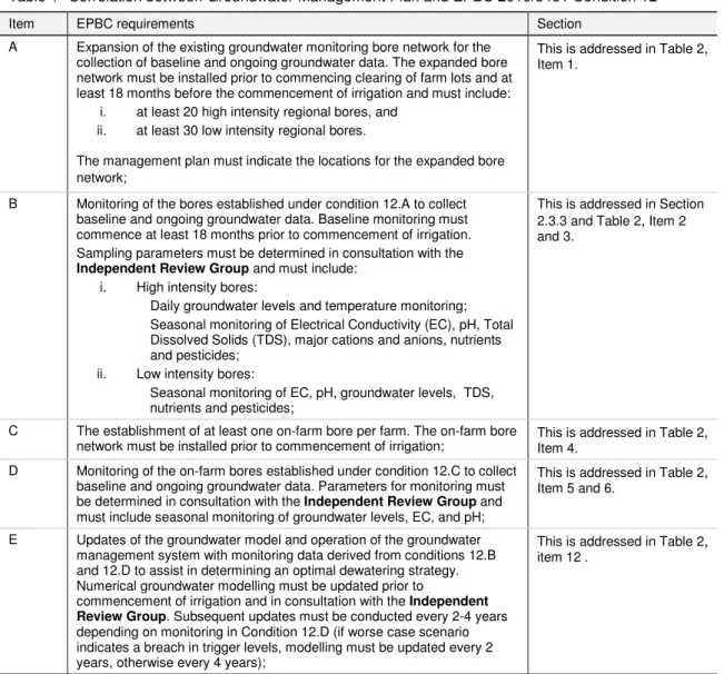
Expansion of the existing network of groundwater monitoring channels for the collection of baseline and continuous groundwater data. D Monitoring of on-farm wells located in condition 12.C to collect baseline and ongoing groundwater data. E Groundwater model updates and groundwater management system operation with monitoring data derived from conditions 12.B and 12.D to help determine an optimal dewatering strategy.
J Monitoring boreholes established under Condition 12.I to collect baseline and ongoing groundwater data.
Relationship to other management plans
Description of groundwater
Groundwater entry is expected to occur due to irrigation and increased recharge from rainfall over the vacated proposal area. Groundwater level rises could potentially lead to flooding and potential salinization of the land if not adequately managed. Modeling by KBR (2011) has been performed to facilitate predictions of where groundwater rise is expected to occur within the proposed area.
Because baseflow in the Keep River in the K4 pool is primarily controlled by the groundwater gradient, a change in water table elevation below Weaber Plain may also have an additional effect on baseflow rates. The groundwater base flow rate in the Keep River in the K4 pool has increased naturally since 2000 and is currently estimated to be around 25 L/s during the dry season. Baseline groundwater flow in the K4 pool from Weaber Plain is modeled by baseline and some.
The base flow rate is expected to further increase by approximately 63%, as a result of recent climate-forced groundwater level rise (KBR 2011). The modeled change in the future base flow to K4 Pool is expected to be between approximately 43% for development without groundwater management (Scenario 2), and 8% for development with groundwater management. In the unlikely event that increases in base flow to K4 pool (under Scenario 3) have an adverse impact on the environment of the Hou River, the groundwater pumping strategy will be revised to increase withdrawal rates at the eastern boreholes within the Development Area. (as described in the Aquatic Fauna Management Plan).
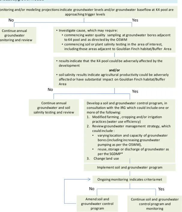
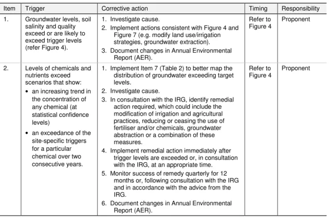
To ensure that groundwater rise does not have a significant adverse environmental impact on the Affairs of NES, the proposed action involves improved management of groundwater through a combination of. The modeling indicates that the implementation of the groundwater management and contingency measures will be successful in controlling groundwater levels. If groundwater rise as a result of the development is likely to cause unacceptable impacts that would not have occurred under the no-development situation, Section 2.3.3 and Figure 4 outline the triggers for the.
The trigger values will be constantly re-evaluated based on the results of the baseline survey and ongoing monitoring of aquatic fauna and water quality.
Management
- Environmental aspects to be managed
- Environmental objectives
- Management actions and monitoring regime
- Management actions commenced and/or implemented
- Management measures/strategy
- Monitoring framework
- Management and monitoring actions
- Contingency Framework
- Performance reporting
- Annual Environmental Report
- Triennial Performance Review Report
- Audit
Interim triggers based on annual averages will be re-evaluated and replaced with site-specific triggers (probability/exceedance measures) when baseline and ongoing monitoring data determined in consultation with the IRG are available. Until water quality data from the groundwater outfall pipeline is available (when abstraction occurs), reference well groundwater samples will be used in conjunction with an operational surface water model to predict water quality downstream of the development site. The groundwater extraction strategy will be reviewed if increases in base flow to the K4 basin resulting from the development are shown to have an adverse impact (based on future modeling and water quality data) on the downstream environment.
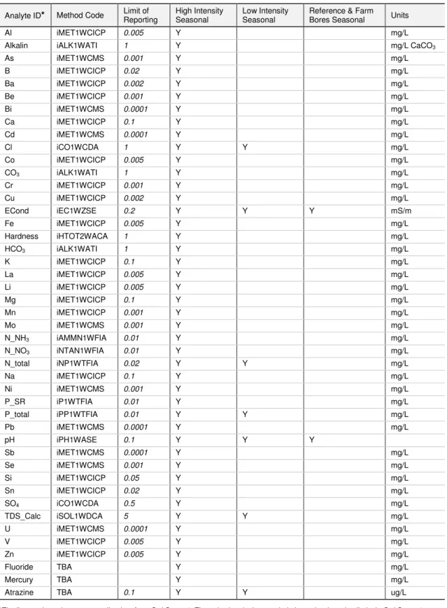
A register of all chemicals used on farms in the Development Area will be maintained as described in the Chemical Management Sub-Plan. The list will be updated taking into account on-farm practices and ongoing analyte monitoring in consultation with the IRG. Groundwater quality will be assessed against site-specific triggers defined in accordance with ANZECC & ARMCANZ (2000) guidelines.
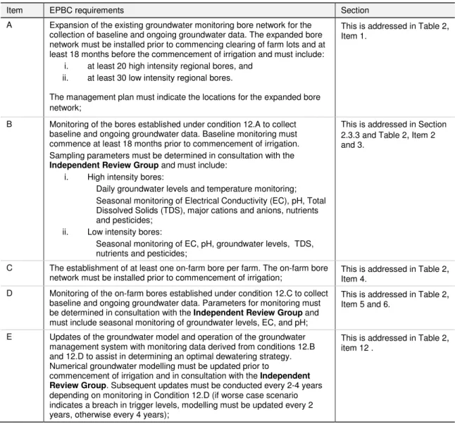
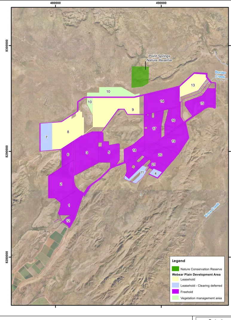
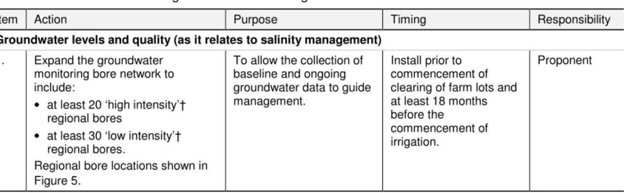
Monitoring of groundwater levels and quality will be carried out at both regional and local level. At least 20 'high intensity' and 30 'low intensity' regional boreholes across the proposal area will be monitored as part of the monitoring borehole network (Table 2, points 1 and 3). The site for each 'on-farm' borehole will be chosen within the operation and not near the main ditches/swamps (reservoirs).
Monitoring data will be collected (Table 2, Items 3, 6 and 9) and a groundwater level and quality database will be established and maintained for the duration of the Proposal following the establishment of the borehole network (Table 2 , Item 10 and 11). The list was based on water quality monitoring results from Phase 1 of the Order and will be updated annually based on ongoing monitoring and amended in accordance with farm practices (as advised by the Chemicals Management Subplan) and in consultation with IRG. Any proposed changes in sampling and parameter analysis will be determined in consultation with the IRG following the preparation of the Annual Environmental Report (Section 2.5).
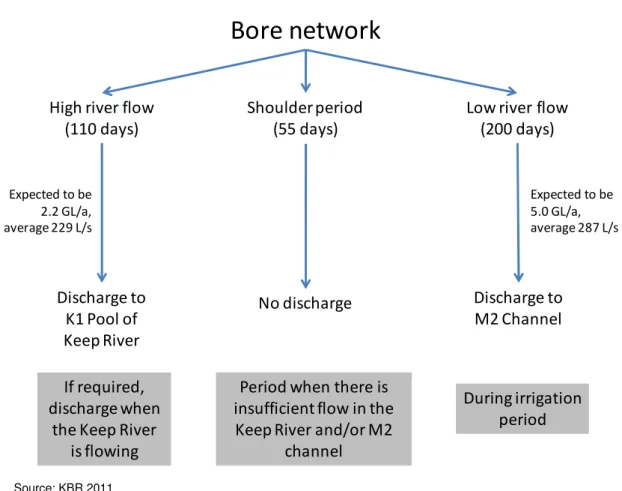
If site-specific threshold values for nutrients or chemicals are exceeded, the exceedances are mapped out and the cause investigated. Groundwater is discharged in accordance with the indicative groundwater discharge framework in Figure 7 and in accordance with the Operational Surface Water Model (OSWM) included in the SGDMP. These rules will be refined based on the results of ongoing monitoring and baseline monitoring of the water quality of the Border Creek and Keep River systems.
Performance reporting of this groundwater management plan will be implemented in accordance with the reporting requirements set forth in the Ord River Irrigation Area – Weaber Plain Development Project Environmental Management Plan (Ord EMP), which includes systematic, comprehensive and informative environmental management and monitoring reports for the Proposal Area ( Strategen 2011a). The same audit report will be submitted to address compliance reporting required in Statement 830 (State Approval).
Review and revision