North Kellyville City Council
Draft SEPP (Sydney Region Growth Centres) 2006 (Amendment No 3 )
Planning report
Contents Page
1. Summary ... 4
2. Exhibition Details ... 5
3.1 Exhibited Materials ... 5
3.2 Exhibition Period ... 5
3.3 Exhibition Venues ... 5
3.4 Public Notice ... 5
3.5 Notification of Landholders ... 6
3.6 Notification of Key Stakeholders ... 6
3.7 Landowner Briefing Sessions ... 6
3. Submissions Summary ... 7
3.8 Number of submissions ... 7
3.9 Late Submissions ... 7
3.10 Response to Submissions ... 7
3.11 Summary of Submissions ... 8
3.12 Constrained Land ... 9
3.13 Riparian Assessment issues... 9
3.14 SEPP Instrument...10
3.1.1. Land Use...10
3.1.2. Environmentally sensitive areas excluded...10
3.1.3. Height of Buildings...10
3.1.4. Vegetation Controls...10
3.1.5. Development on land in Zone E4 Environmental Living...11
3.1.6. Community Title Subdivision...11
3.15 SEPP Maps...11
3.1.7. Minimum Lot Size...11
3.1.8. Height of Buildings Map...11
3.1.9. Retained Native Vegetation Map...11
3.16 Indicative Layout Plan ...12
3.17 Water Cycle Management Strategy ...12
3.18 Biodiversity Certification ...12
3.19 Bushfire Risk...13
3.20 Growth Centre and Precinct boundaries ...13
3.21 Structure Plan ...13
3.22 Development Control Plan Issues...13
3.1.10. Residential Subdivision Controls...14
3.1.11. Complying Development...14
3.23 Section 94 Contributions Plan Issues...15
3.24 Bus Services ...16
3.25 Agency infrastructure requirements ...16
3.26 Planning Process issues ...18
3.27 Planning policy matters resolved following exhibition ...19
4. Consistency with State Policies ... 20
4.1. Growth Centres Structure Plan ...20
4.2. Growth Centres Development Code ...20
4.3. Other relevant SEPPs and REPs...21
4.4. Section 117(2) Directions ...22
Appendix A: Summary of Submissions... 25
Appendix B: Key Stakeholders notified by mail of the public exhibition... 63
Appendix C: Compliance with Growth Centres Development Code... 64
1. Summary
The Minister for Planning announced on 29th May 2008 that he would publicly exhibit a draft amendment to State Environmental Planning Policy (Sydney Region Growth Centres) 2006 (Amendment No 3), to rezone the North Kellyville Precinct to facilitate urban development.
The package of exhibited documents included the amendment to the Growth Centres SEPP to include rezoning provisions which will ultimately be transferred to The Hills Shire Council’ comprehensive Local Environmental Plan; Development Control Plan to guide the assessment of subdivision and
development applications; and Section 94 Contributions Plans prepared by The Hills Shire Council.
The suite of documents will:
rezone and establish development standards for the North Kellyville Precinct;
include controls to meet residential density targets and improve design quality outcomes;
simplify the complying development process and broaden the range of residential development which will be able to use this process; and
identify local infrastructure to support future residents.
Following public exhibition of the draft plan and associated planning documents, the Growth Centres Commission in close collaboration with The Hills Shire Council has undertaken an extensive review process to finalise the documents.
This report documents the public consultation process, summarises the issues raised both in
submissions and during further discussion with state agencies and other stakeholders, and reports on how they have been addressed in the finalisation of the precinct plan.
Summary statistics North Kellyville Precinct
Gross Area 706.2ha
Net Developable Area (NDA) 470.3ha
Residential Lots 5,185
Average Residential Density (Net) 11 dwellings per hectare
Population 15,563
Retail Gross Floor Area (GFA) 19,000m2
(15,000 Local Centre + 2 x Neighbourhood Centres)
Employment Land NA
Commercial (Office) Gross Floor Area (GFA) Est 3,000m2 (not prescribed)
Local Open Space (incl drainage) 51ha
Riparian Protection Areas 132ha
Jobs 729
Regional Infrastructure in accordance with the SIC Practice Note
Proposed upgrades to Commercial Road between Withers Road and Caddies Creek (instead of Mile End Road), land for 1 public primary schools and fare box subsidy for public
transport services.
2. Exhibition Details
3.1 Exhibited Materials
Draft State Environmental Planning Policy (Sydney Region Growth Centres) 2006 (Amendment No 3) (SEPP)
Draft Development Control Plan (DCP) for the North Kellyville Precinct
Draft Indicative Layout Plan (ILP) for the North Kellyville Precinct
Draft Precinct Planning Report (ILP Summary Report)
Background Reports
Draft Section 94 Contributions Plan for the North Kellyville Precinct
Draft Amended North West Structure Plan map
Draft Amended North West Development Control Plan map
A Guide to the exhibition and three Fact Sheets were also available to explain the exhibition material.
3.2 Exhibition Period
The draft SEPP and associated exhibition documentation was publicly exhibited for four weeks from 30 May 2008 to 4 July 2008.
3.3 Exhibition Venues
Growth Centres Commission, Level 5, 10 Valentine Avenue, Parramatta
Department of Planning, 23 - 33 Bridge St, Sydney
Hills Shire Council, 129 Showground Road, Castle Hill
Castle Hill Library, Cnr Castle & Pennant Streets, Castle Hill
Vinegar Hill Memorial Library, 29 Main Street, Rouse Hill Town Centre
Growth Centres Commission web site
Link to GCC website from The Hills Shire Council website 3.4 Public Notice
Advertisements were placed in the following newspapers:
Media Appearance Dates Placement
Sydney Morning Herald 30/05/2008 Early General News
4/06/2008 Government Noticeboard
Daily Telegraph 30/05/2008 Early General News
4/06/2008 Government Noticeboard
Hills News 3/06/2008 Early General News
Hills Shire Times 3/06/2008 Early General News
Northern News 3/06/2008 Early General News
Rouse Hill Times 4/06/2008 Early General News
National Indigenous Times 12/06/2008 Early General News
Koori Mail 4/06/2008 Early General News
Sydney Morning Herald 30/05/2008 Early General News
3.5 Notification of Landholders
The Growth Centres Commission wrote to 282 landholders on 29 May 2008 advising of the public exhibition. This notification also included properties that directly adjoin the Precinct.
3.6 Notification of Key Stakeholders
The Growth Centres Commission wrote to 88 other key stakeholders on 2 June 2008 advising of the public exhibition and enclosing a full copy of the exhibition documentation on CD. These stakeholders included the Local Councils, Sydney Water and other State Agencies, and environmental and development industry interest groups, as listed at Appendix B.
3.7 Landowner Briefing Sessions
Regular meetings have been held with landowners within the Precinct throughout the development of the Precinct Plan. No meetings were held during the exhibition period, however individual site meetings were attended on request.
3. Submissions Summary
3.8 Number of submissions
A total of 108 submissions were received. Submissions were accepted by mail and email. All submissions are listed and summarised at Appendix A: Summary of Submissions.
Table 1: Group submissions received from:
Received From No. of Submissions
State Government Agencies 10
Local Government 1
Landowners 85
Utilities 3
Industry Groups 3
Environmental Groups 1
Landowner Groups 5
TOTAL: 108
3.9 Late Submissions
While the formal closing date for submissions was the close of public exhibition on 04 July 2008, submissions received up to 27 August were able to be considered. No formal extensions were granted.
3.10 Response to Submissions
All submissions have received a letter of acknowledgement. A further response will be sent to advise of the Minister’s decision and to advise in general terms of how matters raised have been responded to.
3.11 Summary of Submissions
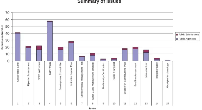
Submissions from landowners and stakeholders on the Precinct Planning Package were generally positive as reflected in the UDIA’s submission which commented on “the pragmatic approach taken by the Growth Centres Commission to delivering a balanced outcome for North Kellyville”.
A majority of submissions received related to development on environmentally sensitive land where large lot subdivision is proposed. The keys issues in relation to environmentally sensitive land included the feasibility of 4,000sq.m lots, accuracy of steep land and vegetation mapping, support for the public acquisition of all riparian corridors and concern regarding the identification of bushfire risk.
Provided in Figure 1 is a summary of issues raised in submissions. A detailed response to key issues is addressed in detail below.
Figure 1: Summary of issues
Summary of Issues
0 10 20 30 40 50 60 70
Constrained Land Riparian Assessment SEPP Instrument SEPP Maps Development Control Plan Indicative Layout Plan Environmental Management Plan Water Cycle Management Strategy Biodiversity Certification Public Transport Section 94 Contributions Plan Bushfire Assessment Infrastructure Implementation Aboriginal Archaeology
1 2 3 4 5 6 7 8 9 10 11 12 13 14 15
Issue
Submission Number
Public Submissions Public Agencies
Consideration of Issues
This section identifies the issues raised in submissions, and also those raised in ongoing discussions with state agencies and key stakeholder groups. The GCC has formed a position in relation to these issues by balancing a range of competing views, in the context of state planning policies and guidelines, and informed where necessary by additional specialist advice.
3.12 Constrained Land
The exhibited Indicative Layout Plan has been amended to delete the constrained land layer.
Constrained land was defined in the ILP Summary Report as land identified in both the Steep Land Map and Retained Native Vegetation Map. Submission authors raised concern regarding the relative complexity and accuracy of defining a constraint based on two separate mapping layers.
Clause 6.2 and 6.3 of the exhibited SEPP gave effect the mapping of constrained land. Based on proposed amendments to the SEPP as detailed in 3.1.5, the term “constrained land” is no longer referenced in the Indicative Layout Plan.
3.13 Riparian Assessment issues
In order to streamline development approval processes, it is the intention of Growth Centres Commission to achieve an exemption from the requirement to obtain a “Controlled Activity Approval” under the Water Management (General) Regulation (2000). To support this outcome, a riparian assessment report was commission by the GCC to inform the preparation of the Riparian Protection Map, consistent with the approach applied in the Oran Park Turner Road Precincts.
The Department of Water and Energy (DWE) has proposed the preparation of a Waterfront Land Strategy to be gazetted pursuant to the Water Management (General) Regulation (2004) which will form the basis of an exemption from the requirement to hold controlled activity approvals. It is intended that the Waterfront Land Strategy will apply to the Growth Centres and become effective in each precinct upon the completion of Precinct Planning.
It is intended that the gazettal of the Waterfront Land Strategy for North Kellyville will enable activities within or adjoining riparian corridors to be approved by Council without referral to the NSW Department of Water and Energy provided it meets the requirements of the Strategy. This approach achieves the global approval required by Growth Centres Commission and an
appropriate level of control over activities in riparian corridors.
The DWE maintains that Category 1 and 2 watercourses are to be retained, protected and enhanced for the purposes of natural environmental protection irrespective of the land use zoning and the associated permissible uses. To support this view, the DWE have produced a stream classification map that applies to the North West Growth Centre to benchmark future detailed assessments undertaken during precinct planning. The classification map is based on the Riparian Corridor Objective Setting (RCOS) stream categorisation method which is detailed within the Growth Centres Development Code.
The exhibited Riparian Protection Area Map has been amended to reflet the requirements of RCOS stream classification method. Based on consultation with DWE, variations to the RCOS method have been agreed in areas to ensure that stream corridor widths do not pose a bushfire risk in areas where perimeter housing is planned. In such cases, adjoining road corridors will include a 10m Managed Ecological Zone to achieve the function of a vegetated buffer with the objective of achieving ecological protection, stormwater management and asset protection.
Details relating to the location and assessment criteria applicable to Managed Ecological Zones are provided in the North Kellyville DCP and will be addressed in the Waterfront Land Strategy under preparation for North Kellyville.
In summary, the area of land subject to riparian corridor protection has increased from 69ha to 132ha to ensure consistency with the DWE RCOS method.
3.14 SEPP Instrument
The SEPP Amendment has been prepared in a format consistent with the Department of Planning’s Standard Instrument for Local Environmental Plans (“LEP Template”). Although a SEPP is not legally required to be in this format, this will facilitate the eventual integration of the North Kellyville Precinct provisions into The Hills Shire Council’s comprehensive Local
Environmental Plan, which is currently being reviewed in light of the LEP Template.
Key issues relating to the SEPP are outlined below:
3.1.1. Land Use
The Land Use Table has been updated to ensure that where possible group terms are used based on the land use matrix provided by the Department of Planning. In addition, Secondary Dwellings have been added to the permissible use list within the R2 Low Density Residential Zone with a minimum lot size provision of 550m2 under Clause 4.1A.
3.1.2. Environmentally sensitive areas excluded
As implemented in Oran Park and Turner Road Precincts, the North Kellyville DCP identifies that dwellings created on lots at least 450m2 with a frontage of at least 15m are capable of accommodating complying residential development. An anticipated 50% of detached residential lots may ultimately be able to meet these requirements, which is expected to result in a
significant reduction in development applications needing to be assessed by Council.
The exhibited draft SEPP did not exclude exempt or complying development on land identified as bushfire prone under Section 146 of the EP&A Act. Sections 79BA of the EP&A Act and Section 100B of the Rural Fires Act requires concurrence from the NSW Rural Fire Service for development on bushfire prone land. Accordingly, Clause 3.3 (Environmentally sensitive areas excluded) of the SEPP has been updated to reference bushfire prone land.
3.1.3. Height of Buildings
The exhibited SEPP Amendment made provision under Clause 4.3(2A) for the consent authority to grant development consent for nominated residential uses that exceed the 9m building height control if located on a prominent street corner, adjacent to a commercial centre or was located on land exceeding 15% slope.
It is proposed to extend the operation of this clause to apply to land zoned R2 Low Density Residential and to also include schools and places of public in worship that are commonly provided within residential areas. Council is currently is pre development application consultant with a proponent who is proposing a school that cannot meet the exhibited building height controls. It is considered that the proposed amendment allows Council sufficient scope to undertake a merit assessment of the proposal.
3.1.4. Vegetation Controls
To address Condition 10 of the Order granting biodiversity certification to the Growth Centres SEPP, the North Kellyville Precinct Plan requires appropriate vegetation controls for proposals to clear land shown as non-certified in the Order. To ensure that the current vegetation controls under Part 6 of the State Environmental Planning Policy (Sydney Region Growth Centres) 2006 are carried over into The Hills Shire Council’s Local Environmental Plan 2005, it is proposed to exclude the operation of this part to the North Kellyville Precinct. Instead, controls for the clearing of vegetation will be inserted within Appendix 2 of the SEPP with additional provisions to address the offset requirements of the Biodiversity Certification Order.
This process will ensure that the North Kellyville Precinct Plan provides sufficient guidance to The Hills Shire Council and land owners regarding the requirements of the Order.
3.1.5. Development on land in Zone E4 Environmental Living
The exhibited SEPP included provisions that prohibited the clearing of vegetation and construction of driveways on land shown on the Steep Land Map and Retained Native Vegetation Map. The DECC considered this approach to be unnecessarily complex and recommended that the SEPP be simplified to clearly identify protected vegetation. Furthermore, public submissions contended that the total prohibition on clearing of protected vegetation and development on steep land exceeded the existing provisions of the SEPP and Biodiversity Certification Order.
To address these valid concerns, Clause 6.3 of the exhibited SEPP and Steep Land Map has been deleted. Matters associated with geotechnical stability and stabilisation works will instead be addressed by the North Kellyville DCP and relevant Australian standards for construction on steep land.
3.1.6. Community Title Subdivision
The draft SEPP amendment included provisions (Clause 6.4) to permit community title
subdivision of land in Zone E4 Environmental Living for no more than 7.5 dwellings per hectare and a minimum lot size of no less than 600m2. Clause 6.4 specifically excluded land identified within the Riparian Protection Area Map, Retained Native Vegetation Map or Steep Land Map.
The exhibited SEPP has been amended to allow the inclusion of riparian and protected vegetation within the area calculation for community title subdivision. The purpose of this amendment is to attribute development value to environmentally sensitive lands to promote site amalgamation and preparation of environmental management plans for their ongoing
maintenance.
To support this development outcome, the North Kellyville DCP has been amended to include a section on community title subdivision with development objectives and controls considered necessary to promote good urban outcomes.
3.15 SEPP Maps
3.1.7. Minimum Lot Size
A key issue arising from exhibition related to the minimum lot size on land Zoned E4
Environmental Living which varies between 2,000 sq.m and 4,000 sq.m depending on location.
Landowners generally accepted 2,000 sq.m lots, however concern was raised regarding the potential market and cost of selling 4,000 sq.m lots with equivalent properties selling for $1.4 million in adjoining suburbs.
Due to environmental constraints, the GCC maintain that 4,000 sq.m lots are appropriate for North Kellyville. As detailed in 4.3.4 above, amendments to the community title subdivision provisions of the SEPP reward this form of development which has the potential generate appropriate development and environmental outcomes.
3.1.8. Height of Buildings Map
The exhibited Height of Buildings Map identified that development within the R3 Medium Density Residential Zone and B2 Local Centre Zone not exceed 14m. To ensure consistency with The Hills Shire Council’s future Template LEP, it is proposed to permit 16m development which throughout The Hills Shire has achieved high quality four storey development.
An additional amendment is proposed to permit 16m development within and adjacent to the southern neighbourhood centre. The draft DCP includes a master plan for this centre with opportunity for mixed use or apartment building development. This amendment will ensure consistency with the exhibited DCP.
3.1.9. Retained Native Vegetation Map
The exhibited Retained Native Vegetation Map has been renamed and amended to address implementation of vegetation management controls associated with the Growth Centres
Biodiversity Certification Order (the Order). The exhibited plan mapped the extent of vegetation to be protected by the SEPP which generally correlated on land with a slope greater than 20%.
The Retained Native Vegetation Map has been renamed “Native Vegetation Protection Map”
and now includes the identification of existing native vegetation identified under the Growth Centres Biodiversity Certification Order (the Order).
3.16 Indicative Layout Plan
The exhibited indicative layout plan has been amended to address the outcome of more detailed investigation and response to issues raised in submissions. Key amendments include the deletion of the Constrained Land layer and amendment to the “Medium Density Residential”
layer to ensure consistency with the Land Use Zoning SEPP Map.
Roads adjoining public open space have been adjusted in line with Council’s requirement for developers to be responsible for the full width of road construction adjoining open space.
3.17 Water Cycle Management Strategy
The North Kellyville Water Cycle Management Strategy (WCMS) has been prepared to demonstrate compliance with DECC targets for water quality and quantity. The WCMS
implements a treatment train approach with an emphasis on source control. The strategy makes provision for rainwater tanks on all residential dwellings to service domestic hot water uses.
Council has since raised concerns about potential contaminants entering the rainwater tanks, and the storage temperatures required to neutralise such contaminants. Ultimately, Council considered the storage temperatures to be excessively high and flagged the potential impacts of scalding residents.
The strategy has since been amended to permit harvested rainwater to service domestic washing machines. Discussion with the NSW Department of Health in regards to using harvested rainwater has identified that health issues arising from using rainwater to wash clothes as being minimal and low risk subject to compliance with their requirements as detailed within ‘Rainwater Tanks’ (NSW Health), and ‘Guidance on Use of Rainwater Tanks’ (enHealth Council).
The provision of rainwater tanks in North Kellyville represents a significant infrastructure cost saving of approximately $10,000 per dwelling.
3.18 Biodiversity Certification
Part 7 of Schedule 7 of the TSC Act refers to “relevant biodiversity measures” non-compliance with which gives the Minister for Climate Change, Environment and Water the discretion to suspend or revoke the biodiversity certification of the Growth Centres SEPP.
In accordance with Condition 35 of the”relevant biodiversity measures”, a consistency report titled “Report on Consistency of Proposed North Kellyville Precinct Plan with the Biodiversity Certification Order” (‘the Consistency Report’) was exhibited with the SEPP.
In order to meet the “relevant biodiversity measures”, at least 34 hectares of existing native vegetation as defined by the “relevant biodiversity measures” should be retained within in the North Kellyville Precinct. In addition, adequate protection must be provided for several threatened flora species recorded within and adjacent to the Heath Road remnant.
The DECC assessment of the Consistency Report concluded that the following additional actions were required prior to gazettal of the SEPP:-
Submission of an expanded rationale recommending that the Minister for the
Environmental and Climate Change uses condition three of the “relevant biodiversity measures” to delete the transitional lands development control overlay, amend the certified and non-certified boundary.
Improved mapping to show the location of existing native vegetation to be protected or cleared. The location of these areas and the methodology used to classify the
vegetation would need to be verified by DECC.
The GCC has made amendments to the SEPP and Compliance Report to address the DECC’s requirements. In summary, 30ha of the required 34ha hectares of existing native vegetation will be protected within non-certified land. The shortfall of 4ha will be offset by 5.06 hectares of certified existing native vegetation within the North Kellyville Precinct.
Amendments arising from this review impact the exhibited Indicative Layout Plan and SEPP with some land previously identified as urban now requiring an Environmental Living Zone and protection of vegetation.
3.19 Bushfire Risk
It is the intention of the GCC to pursue an amendment to the Rural Fires Act to permit Precinct level approval under the EP&A Act and Rural Fires Act. As an interim measure, the NSW Rural Fire service has suggested that the Baulkham Hills Bushfire Prone Land Map be amended to only reflect protected vegetation identified in the North Kellyville Native Vegetation Protection Area Map.
This approach would ultimately remove referral requirements for a majority of land capable of conventional subdivision within North Kellyville and will be pursued following gazettal of the SEPP Amendment.
3.20 Growth Centre and Precinct boundaries
The Precinct and Growth Centres boundaries remain as exhibited. The precinct planning process resulted in the minor adjustment to the North Kellyville Precinct / Growth Centre boundary. The amendment has arisen from detailed ground-truthing of streams and alignment with the existing Baulkham Hills Local Environmental Plan 2005 to avoid the creation of un- zoned land. The proposed boundary adjustment has no impact on the development yield within the North Kellyville Precinct or adjoining areas.
3.21 Structure Plan
Base on detailed precinct planning, the Transitional Lands mapping layer has been deleted from the North West Growth Centre Structure Plan Map. This layer will be replaced by the Native Vegetation Protection Area Map which identifies protected vegetation based on more detailed ground-truthing.
The amendment to the North West Structure Plan Map to remove the Transitional Lands layer in North Kellyville inadvertently also deleted Transitional Lands in the Marsden Park Precinct. This map has been amended to reinstate this layer.
3.22 Development Control Plan Issues
An extensive and detailed review of the draft Development Control Plans has been undertaken since the exhibition period ended. All submissions relating to the DCP have been reviewed by the GCC in close consultation with The Hills Shire Council and relevant stakeholders.
3.1.10. Residential Subdivision Controls
(i) Riparian perimeter roads
To support agreed outcomes with the Department of Water and Environment, the road section plan for public roads adjoining nominated riparian corridors has been amended to include a 10m buffer area known as a managed ecological zone (MEZ). The purpose of an MEZ is to facilitate ecological protection, stormwater management and asset protection adjoining riparian corridors that have not been allocated a vegetated buffer required under the DWE Riparian Corridor Objective Setting (RCOS) method.
This approach benefits landowner and developers by permitting the bushfire asset protection zone within the MEZ which is to be managed as open woodland. This approach differs from DWE’s current position of prohibiting asset protection zones within outer protection zones of riparian corridors.
Whilst the DCP has been amended to give effect this process, the Waterfront Land Strategy for North Kellyville will address the detailed requirements needed to achieve an exemption from the requirement to obtain a “Controlled Activity Approval” under the Water Management (General) Regulation (2000)
(ii) Street Design
To support the orderly development of North Kellyville, temporary road and partial width construction controls have been included in the DCP. Due to the topography, design and drainage requirements, half road width construction may not always be feasible in North Kellyville. Accordingly, to support the merit assessment of development applications, appropriate development controls have been included in the DCP.
(iii) Community title subdivision
To support the objectives of the Growth Centres SEPP (Amendment No.3), controls to support Community title subdivision have been included in the DCP. The controls seek to encourage the sustainable development of community lots on land zoned E4 Environmental Living. The amended DCP stipulates the minimum no of lots required and obligations with respect to managing land as shown on the Native Vegetation Management Plan and Riparian Protection Area Map. Illustrative examples have been included to support the development controls which seek to achieve street oriented and accessible subdivision designs.
(iv) Stormwater Management
To address the requirements of the DECC, the DCP has been amended to provide integrated stormwater management controls that implement the recommendations of the North Kellyville Water Cycle Management Strategy (WCMS). The North Kellyville WCMS has been prepared to comply with the Environmental Stormwater Objectives in the Western Sydney Growth Centres – Stormwater Guidance for Precinct Planning (2006, Managing Urban Stormwater: Stormwater Planning (DECC) and Australian Runnoff Quality (Engineers Australia).
3.1.11. Complying Development
(i) Floor to ceiling heights
Controls for detached dwellings as complying development previously developed for Oran Park and Turner Road Precincts are included in the North Kellyville DCP with amendments to suit local residential design controls. A key difference between the North Kellyville and Oran Park Turner Road complying development provisions is the omission of a floor to ceiling height controls. Instead, the DCP will rely on the Building Code of Australia to prescribe ceiling height controls. The purpose of this amendment is to address concerns from the development industry with respect to BCA requirements and development costs and is consistent with the Department of Planning’s Housing Code (under review).
(ii) Stormwater management controls
The DCP requires residential dwellings to include rainwater tanks and rain gardens to address the stormwater attenuation targets of the DCP. To ensure that complying dwellings meet the
required stormwater attenuation targets, the Section 88B instrument for the parent subdivision will identify the required stormwater management measures to be met.
3.23 Section 94 Contributions Plan Issues
The Hills Shire Council exhibited their North Kellyville Precinct S94 Contributions Plan No.13 concurrently with the North Kellyville Precinct Plan.
At the time of exhibition, the Section 94 Plans provided the following contribution rates by type of dwelling:
DEVELOPMENT TYPE $: RATE PER
DWELLING
Subdivision, Dwelling Houses and Dual Occupancies 50,702,04
Integrated Housing, 40,263.38
Multi Unit Development
4 Bedroom 45,841.59
3 Bedroom 36,487.39
2 Bedroom 23,653.39
1 Bedroom 13,513.04
The above rates are primarily influenced by land values which are significantly higher in the Hills Shire Local Government Area than the South West Growth Centre. Land acquisition
represents 51.2% of the total plan and is based on the assessment of values obtained from a qualified valuer. The assessment of values has regard to any recent sales activity, general market conditions and draft planning controls associated with the North Kellyville Precinct Plan.
The Contributions Plan identifies facilities and services required for the expected development and resulting population in North Kellyville. The costs of facilities contained within the
Contributions Plan were independently prepared and subject to review following exhibition.
Revised costs for road construction are 94% greater than the exhibited costs. Prior to adoption of the Contributions Plan, Council will seek independent review of the cost methodology.
Since exhibition, the GCC and The Hills Shire Council have amended the plan to include commercial / retail and senior living development. Further amendments are also proposed to address the form and structure of the plan, nexus, apportionment and indexation considerations.
The North Kellyville Precinct Plan provides for a total of 19,000sq.m of commercial floorspace contained within one Local Centre (15,000sq.m) and two small neighbourhood centres (4,000sq.m). The requirement to seek contributions from commercial/ retail development is considered appropriate on the basis that demand for traffic and water management facilities will be generated from the three planned commercial centres.
As the Growth Centres Special Infrastructure Levy does not require payment of contributions from commercial / retail development, contribution towards local facilities is considered appropriate and will be considered in future release precincts by the GCC.
The amended contribution rates as prepared since exhibition are:
RESIDENTIAL DEVELOPMENT TYPE $: RATE PER
DWELLING
Subdivision, Dwelling Houses and Dual Occupancies $48,711.20
Integrated Housing, $38,682.28
Senior Housing $18,624.80
Multi Housing Dwellings
4 Bedroom $44,041.44
3 Bedroom $35,054.57
2 Bedroom $23,883.09
1 Bedroom $13,644.27
COMMERCIAL DEVELOPMENT TYPE $: RATE PER M2 OF GLA
Supermarket and Grocery Store $961.10
Specialty Retailing $1403.49
Non Retail Commercial $1373.00
The amended Contributions Plan provides a contribution rate per dwelling of less than $50,000 which is considered reasonable in to context of the land market in the North West Growth Centre.
The GCC has recently written to the Director General of the Department of Planning in respect to transitional arrangements for implementation of the new contributions system for the state.
The GCC has sought that Contributions Plans currently operation or under preparation (Ie North Kellyville) are to be saved under the current plan making process under the existing EP&A Act.
The Ministerial Direction with respect to the preparation of Contributions Plans within the Growth Centres (January 2008) is also sought to be saved for North Kellyville as Council is likely to adopt the Contributions Plan before the new legislative framework coming into force. As
Council has committed to an annual review and re-exhibition of the North Kellyville Contributions Plan, Council will revise the plan to conform to the new framework mid 2010.
3.24 Bus Services
Many submissions identified the need for buses to service new residents to maximise
opportunities to reduce car dependency. The Hills Shire Council submits that an implementation program is required to promote changes in travel behaviour as the precinct develops.
The Growth Centres Special Infrastructure Contribution includes the provision of funds to subsidise fare box revenue for the first 5 years of operation on each route. The GCC is working closely with the Ministry of Transport with the view to ensuring adequate budget allocations for a viable service commensurate with the progressive development of the North Kellyville Precinct.
3.25 Agency infrastructure requirements Regional Roads
The Road and Traffic Authority have identified that longer term traffic growth as a result of the North Kellyville Precinct will place additional traffic pressure on key roads such as Samantha Riley Drive, Commercial Road and Withers Road which serve as key link roads between North Kellyville Precinct and Windsor Road. The RTA has requested that the North Kellyville
Contributions Plan include provision for the upgrading of the following local / State Road intersections:
Old Northern Road / Glenhaven Road ($4 million)
Showground Road / Green Road ($0.6 million)
Windsor Road / Samantha Riley Drive ($0.4 million)
The RTA and Council have agreed for some time on the necessity to upgrade the above intersections to safely accommodate growth in traffic generated by the North Kellyville Precinct and now form part of the amended Contributions Plan.
Local Roads
The RTA has expressed concern over the proposed signalisation of four key intersections within the North Kellyville Precinct on the grounds that insufficient information exists to warrant
signalisation.
Additional modelling has been requested to demonstrate and explain how each intersection would meet the appropriate traffic signal warrants. The RTA maintain that funding for treatment of these intersection should not be resolved until the RTA has reviewed this modelling to determine their design requirements.
The layout and design of the Local Centre and bypass road assumes traffic signal treatment with funding to be collected through S94 Contributions. Notwithstanding the RTA’s concerns, the proposed signalised intersections would operate at an acceptable level of service with a
roundabout treatment and may be resolved at the development stage.
Roundabout treatment of the disputed intersections is not favoured as this would limit pedestrian mobility and be inconsistent with the State Government’s objective of providing walkable
neighbourhoods.
Water services
Sydney Water will deliver water, waste water and recycled water services progressively to North Kellyville from late 2009. Sydney Water have previously exhibited an Environmental
Assessment during February 2008 – April 2008 with project approval from the Department of Planning imminent.
Integral Energy
Integral Energy is proposing to construct the new Mungerie Park Zone Substation (ZS) located on Commercial Road, and commission it in late 2009. When commissioned, this will eliminate the Load Risk for the Kellyville ZS and allow it to supply the North Kellyville Precinct. Mungerie Park ZS is currently at the detailed design stage and Integral Energy does not foresee any delays to this delivery date.
As part of Integral Energy’s long term strategy, the Kellyville ZS will be augmented to a 132kV.
The timing for augmentation of the Kellyville ZS is not certain at this stage and is dependant on growth in demand in both the North Kellyville Precinct and those areas services by the Mungerie Park SZ. Based on current forecasts, Integral Energy envisages that the augmented Kellyville SZ may be required by 2013. As this stage, Integral Energy are comfortable that they will be able to augment their network to service the anticipated staging of development as indicated by the GCC and Sydney Water.
Schools
The GCC and The Hills Shire Council have worked closely throughout the planning process with NSW Department of Education and Training to identify an appropriate site for one primary schools which satisfies the Department’s requirements in terms of site size, location, street frontage and viable catchment area.
The NSW Department of Education has notified the GCC that site acquisition and construction of the primary school identified in the North Kellyville Precinct Plan has been included in the Department of Education and Trainings draft ten year TAM Plan submitted to Treasury. Under this plan, site acquisition and construction is scheduled early in the development of North Kellyville.
Emergency Services
No emergency services are proposed within the North Kellyville Precinct. NSW Rural Fire Service has requested that the 94 funds provide for additional fire fighting resources. Section 94
Contributions cannot be applied to recurrent expenditure and therefore will not form part of the plan.
3.26 Planning Process issues
(i) Relationships with key stakeholders
Regular and comprehensive stakeholder engagement has been a feature of the planning process for the North Kellyville Precinct.
The Hills Shire Council has been actively and positively involved throughout the precinct planning process, and contributed to the day to day project management of the precinct planning process in close consultation with the GCC. Council remains committed to an ongoing relationship with GCC as the precinct proceeds, including infrastructure delivery. Council’s key issues of concern remain with respect to public transport and the objection from the Roads and Traffic Authority to the provision of traffic signals within the precinct.
North Kellyville comprises 282 separate land holdings with an existing population of 765 persons. The landowners have been actively involved in the precinct planning process through two consultation sessions held with local residents during February and August 2007 with excellent attendance recorded. Additional meetings have also been conducted with the three rezoning associations active within the precinct. These groups publish newsletters for their members and have provided a valuable mechanism for public engagement. Landowners have generally been supportive of the consultation process, and the method and level of consultation.
Government agencies have been extensively involved in briefings and issue resolution. Without exception, there has been a high degree of cooperation, underpinned by a recognition of the broader strategic framework established by the structure plan and the SIC. A clear and
consistent approach by GCC since the project inception has seen agencies displaying a greater recognition of the need to balance single issue perspectives. Ongoing co-operation will be necessary to secure on-time infrastructure delivery and to secure precinct-wide approvals.
Industry organisations have generally been positive in their commentary. Development industry commentary has been led by the UDIA. UDIA has supported the process, particularly in terms of the pragmatic approach taken by the GCC to deliver a balanced planning outcome. The Urban Taskforce was more critical of infrastructure levies and their impact on development feasibility.
(ii) Precinct level approvals
The development industry is supportive of the GCC’s continuing efforts to achieve precinct level state agency signoffs, as this will provide greater certainty for agencies, landowners and
developers.
(iii) Regulation under the Water Management Act
The GCC is seeking a Regulation under the Water Management Act that would exempt the need for Controlled Activity Approvals in relation to works within 40m of watercourses in the Precinct (an alternative to the RFI Order under the previous legislative framework). The Department of Water and Environment has provided extensive advice regarding their requirements and work is well advanced to develop Watercourse and Riparian Corridor Strategies that will form the basis for the request for the Regulations.
(iv) Rural Fires Act
Significant areas of remnant vegetation exist within the North Kellyville Precinct and together with the proposed revegetation of the riparian corridors will create a potential bushfire risk.
Areas of low, medium and high bushfire risk have been mapped across the Precinct to assist land use planning decision making.
The GCC is in discussion with the Rural Fire Service to develop a mechanism for a strategic whole of precinct level approval which will negate the need for a s100B authority under the Rural Fires Act 1997. The authorities are required for subdivision of bush fire prone land for residential purposes, or development of bush fire prone land for a special fire protection purpose (such as school, hospital, child care centre).
(v) Aboriginal Heritage
Based on experience in the South West Growth Centre, the feasibility of achieving a Precinct wide Section 90 Consent to Destroy permit is limited due to the fragmented ownership and requirement to achieve landowner consent.
The Growth Centres Commission has prepared an Aboriginal Cultural Heritage Assessment Report in consultation with the Aboriginal Community. The findings of this report are reflected within the North Kellyville Development Control Plan which will require the preparation of Aboriginal Archaeological Management Plans for nominated sites.
(vi) Threatened Species Conservation Act
An order to confer Biodiversity Certification on the Growth Centres SEPP was made on 11 December 2007 on the basis of the exhibited Draft Conservation Plan. Biodiversity Certification effectively ‘turns off’ the Threatened Species Conservation Act thereby removing the need to undertake Species Impact Statements and offset losses of biodiversity values on a site by site basis. These measures will become effective for the North Kellyville Precinct on gazettal of the SEPP Amendment.
As required by the Order, a consistency report was exhibited concurrently with the Precinct Plan. Based on DECC comments, amendments to the SEPP are proposed as detailed in Section 3.18 of this report. An updated copy of the compliance report will be made publicly available pursuant to Condition 4 of the Order.
3.27 Planning policy matters resolved following exhibition
The draft planning documents were exhibited acknowledging that a number of planning issues required further assessment. For those issues requiring resolution prior to rezoning, such as riparian corridor planning and biodiversity certification, further work has been undertaken and sufficient resolution has been reached to enable the rezoning to proceed.
For those issues which are usually resolved prior to development taking place, such as contamination and odour, appropriate controls have been included in the DCP, providing certainty for land owners, developers and the community.
4. Consistency with State Policies
4.1. Growth Centres Structure Plan
The proposed plans are generally consistent with the North West Growth Centres Structure Plan. With the exception of transitional lands, no further changes are proposed to the exhibited Structure Plan, which included the following amendments:
Precinct and Growth Centres boundary changes, as discussed at Section 3.20
Amendment to the hierarchy of the central neighbourhood centre to local centre
Adjustment of the Local Centre location
Updated mapping of the flood liable land
Identification of northern bridge connection to Annangrove Road via Edwards Road The proposed layout of the North Kellyville Precinct provides for walkable neighbourhoods focussed around local parks and community facilities, ensuring a high level of access and amenity to all future residents of the precinct.
The original residential yield ‘guiding element’ for the North Kellyville Precinct under the Structure Plan Explanatory Notes was 4,500 dwellings and 12,600 persons. Detailed precinct planning identified the opportunity to slightly exceed this target with 5,185 dwellings and 15,563 persons proposed. An average density potential of 11 dwellings per hectare has been
achieved. Whilst relatively low, the high proportion (14%) of large lot subdivision lowers the overall density by 2.06ha.
Dwelling density and diversity varies slightly from the explanatory notes based on detailed demographic and development analysis of five similar release areas within the The Hills Shire LGA as detailed below:
Dwelling Type NW Growth Centre Structure Plan – Explanatory Note
North Kellyville S94 Contributions
Plan
Apartments 8% 2.8%
Town Houses 15% 4.7%
Semi detached and detached <450m2 24% 13.7%
Detached medium < or around 450m2 25% NA*
Detached large < 600 22% 61.4%
Detached 1000 - 2000 6% 14.4%
The assumed dwelling diversity rates in North Kellyville are considered appropriate based on the Precinct’s environmentally sensitive areas, connectivity to existing suburbs and bus only public transport. North Kellyville is also in close proximity to the Rouse Hill Town Centre which provides a mix of apartment and smaller detached / attached housing appropriately located next to employment and services with regional public transport services.
4.2. Growth Centres Development Code
The precinct planning process undertaken for North Kellyville, and the resultant SEPP amendment and DCP are generally consistent with the guidance provided in the Growth Centres Development Code. The Code explicitly provides for its ongoing review to reflect the practical lessons learned from detailed precinct planning process, and minor departures from the detailed provisions in the Code in the following areas will form part of that review:
Road Cross-Sections
Detailed road cross sections have been developed for the entire road hierarchy from sub-arterial through to local streets and laneways. These cross sections are incorporated into the DCP.
While based on the Development Code, they do differ in a number of respects. These
differences largely relate to the sub-arterial and collector road network and are considered appropriate.
Street Type Typical Requirements Development Code Requirements
North Kellyville DCP
Sub Arterial
Street Reserve:
travel lanes each way Lane width
Median width On street cycle Outer separator
35m 2 3.5m 7.2m 1.8m 5m
23m 2 3.5m 1.5m NA
5m (includes shared path)
Collector Streets Street Reserve:
travel lanes each way Lane width if located on bus route
18 1 3.5m
20 1 3.5 NA
Local Streets Lane width 3m 3m
Minor Streets Lane width to be determined at DCP stage
NA 3m Town Centre
Streets
Street Reserve Carriageway width Travel-way:
Lane width if on bus route Parking
On street cycle
24.9m 14.4 3.5m 2.5m 1.7m
25m 15.4m 3.5m 2.5m 1.7m
In most cases, the proposed road sections are larger than those in the Development Code. A strong emphasis on landscaping and integration of street trees, cycle paths and pedestrian paths will ensure that the objectives of the Code are achieved. In particular, the road cross sections achieve a balance between quality urban design outcomes and efficient use of land.
The sections have also been prepared in light of detailed traffic modelling and urban design for the precinct.
A detailed summary of the requirements of the Growth Centres Development Code and the proposed precinct plan’s response to this is at Appendix C.
4.3. Other relevant SEPPs and REPs
Relevant Plan Consistency
Draft SEPP 66 – Integrating Land Use and Transport
SEPP 55 – Remediation
SEPP 11 – Traffic Generating Development SEPP 19 – Bushland in Urban Areas
The proposed SEPP is consistent with these SEPPs to the extent they are relevant at this stage. Most relate to the development application stage.
REP 20(2) – Hawkesbury-Nepean River Smalls Creek and Cattai Creek are tributaries and the restoration of these creeks under the Riparian Strategy will see REP 20 objectives met.
4.4. Section 117(2) Directions
A SEPP is not required to conform to s117(2) Directions, which are issued by the Minister under the Environmental Planning and Assessment Act, 1979 as policy guidance for Local
Environmental Plans (LEPs). However as the provisions relating to the North Kellyville Precinct Plan will ultimately be transferred from the SEPP to Baulkham Hill’s comprehensive LEP, the SEPP has been assessed for consistency with the s117(2) Directions (as issued on 17 July 2007) or with respect to the following:
08 Aug 08 - Revocation of Direction 5.6 and Direction 5.7. Amendment of Direction 5.1
09 May 08 - Direction 1.2 - Rural zones
09 May 08 - Direction 2.1 - Environment protection zones
Relevant Direction Relevant Requirement Consistency 1.2 Rural Zones A draft LEP which rezones land from
rural to urban uses must be justified by a strategy approved by the D-G of the Department of Planning, or in
accordance with the relevant Regional or Sub-Regional Strategy.
9
The land is within the North West Growth Centre which is identified as a land release area in the Metropolitan Strategy “City of Cities”.
2. Environment and Heritage
2.1 Environmental Protection Zones
A draft LEP shall include provisions that facilitate the protection and conservation of environmentally
sensitive areas.
9
2.3 Heritage Conservation
A draft LEP shall contain provisions that facilitate the conservation of
environmental or
Aboriginal heritage significance.
9
3. Housing, Infrastructure and Urban Development 3.1 Residential Zones
A draft LEP shall include provisions that encourage the provision of housing that will broaden choice; make more efficient use of existing infrastructure and services; and reduce the
consumption of land; and be of good design. Draft LEPs shall
contain a requirement that residential development is not permitted until arrangements are made for land to be adequately
serviced.
9
3.3 Home Occupations Draft LEPs shall permit home
occupations to be carried out in dwelling houses without the need for
development consent.
9
3.4 Integrating Land Use and Transport
Draft LEPs shall locate zones and include provisions that give effect to and are
consistent with the aims, objectives and principles of:
(a) Improving Transport Choice – Guidelines for planning and development (DUAP 2001), and (b) The Right Place for Business and Services – Planning Policy (DUAP
9
Relevant Direction Relevant Requirement Consistency 2001).
4. Hazard and Risk 4.1 Acid Sulfate Soils
Applies where land has a probability of containing acid sulfate soils, as shown on Acid Sulfate Soils Planning Maps held by the Department of Planning.
Council shall consider the Department’s Acid Sulfate Soils Planning Guidelines and provisions shall be consistent with the Acid Sulfate Soils Model LEP.
A draft LEP that proposes an intensification of land uses on land identified as having a probability of containing acid sulfate soils on the Acid Sulfate Soils Planning Maps unless the council has considered an acid sulfate soils study.
9
The subject land is not identified on the Acid Sulfate Soils Planning maps.
4.2 Mine Subsidence Applies when a draft LEP permits development on land that is within a mine subsidence district, or has been identified as unstable. Council shall consult the Mine Subsidence Board and incorporate required provisions. A draft LEP shall not permit development on identified unstable land.
9
The subject land is not in a declared mine subsidence area.
4.3 Flood Prone Land Draft LEPs shall include provisions that give effect to and are consistent with the NSW Flood Prone Land Policy and the principles of the Floodplain
Development Manual 2005.
9
4.4 Planning for Bushfire Protection
Draft LEPs shall have regard to Planning for Bushfire Protection 2006 and avoid placing inappropriate developments in hazardous areas, and ensure that bushfire hazard reduction is not prohibited within the APZ. Draft LEP shall, as appropriate provide an APZ incorporating minimum requirements.
9
Land uses and development controls in North Kellyville have been determined with respect to APZ requirements.
6. Local Plan Making 6.1 Approval and Referral Requirements
Draft LEPs shall minimise concurrence, consultation or referral and not identify designated development without the D- G’s approval.
9
The SEPP incorporates the LEP Standard Instrument provisions requiring the concurrence of the Director-General in relation to the Exceptions to Development Standards clause; and consultation with the Heritage Council in relation to demolition of items of state significance.
No designated development is identified.
6.2 Reserving Land for Public Purposes
Draft LEPs shall not create, alter or reduce existing zonings or reservations of land for public purposes without the approval of the relevant public authority and the D-G of the Department of Planning.
9
A small area of land adjoining Cattai Creek zoned Open Space 6(a) (Existing and Proposed Public Recreation Zone) Zone will
Planning Report – SEPP (Sydney Region Growth Centres) 2006 (Amendment No 3)
Appendix A: Summary of Submissions Issues raised in submissions have been categorised as identified in the ‘Issues’ column below, and the GCC’s response to key issues is addressed in detail in the body of the report at Section 3. Key Issues: Constrained Land Riparian Assessment SEPP Instrument SEPP Maps Development Control Plan Indicative Layout Plan Environmental Management Plan Water Cycle Management Strategy Biodiversity Certification
Public Transport Section 94 Contributions Plan Bushfire Assessment Infrastructure Implementation Aboriginal Archaeology 1. State Agencies Author Issue No. Issue Summary 16 Department of Education and Training
13 Infrastructure Ten year Department of Education and Training TAM is to be adjusted to align with GCC Indicative Infrastructure Delivery Plan. 17 Sydney Catchment Authority 8 Water Cycle Management Strategy
No objection as North Kellyville is not located within Sydney’s drinking water catchments. 18 Department of Environment and Climate Change
9 Biodiversity CertificationCondition 6 – The location of the proposed 7.09ha of non-certified Existing Native Vegetation (ENV) (to be cleared), 7.04ha of certified ENV (to be protected) and 13.72ha of Shale Sandstone Transition Forest should be mapped (note, however, that a review of the certified and non-certified boundaries may change the location and quantity of the vegetation referred to above). The location of these areas and the methodology used to classify the vegetation would also need to be verified by DECC Officer(s). If a review of the boundaries referred to above shows that offsetting is required, it would be best to demonstrate that this would be done through the protection of an equal or greater area of
Planning Report – SEPP (Sydney Region Growth Centres) 2006 (Amendment No 3)
Author Issue No. Issue Summary existing native vegetation elsewhere in the Growth Centres (refer condition 8 (a)). This would remove the need to demonstrate compliance with the requirements of condition 8 (b) of which the following are the most relevant: Condition 8 (b) (i) – provision of an assessment to confirm that the proposed clearing of Existing Native Vegetation within the non-certified area will not affect the capacity to achieve an overall improvement ormaintenance of biodiversityvalues for threatened species, populations and ecological communities and their habitats. The assessment would need to take into account the definition of persistence of species that is referred to on pages 44 and 53 of the draft Growth Centres Conservation Plan 2007. Condition 8(b)(ii) –mapping of anyrevegetated and/ or restored areas that would be protected by this condition (on the same map referred to in dot point 1 above) i.e.the vegetation protected in the E3 Environmental Management Zone and the E4 Environmental Living Zone. For the current version of the SEPP this includes vegetation on: (1) Land shown on the Retained Native Vegetation Map if the land is within the E3 Environmental Management Zone, (2) Land shown on the Retained Native Vegetation Map and the Steep Land Map if the Land is within the E4 Environmental Living Zone, and (3) Land shown on the Retained Native Vegetation Map and the Riparian Protection Area Map if the land is within the E4 Environmental Living Zone. However, note that the DECC has requested that the relevant provisions in clauses 6.2 and 6.3 of the draft SEPP Amendment be simplified and that the information referred to above be provided on one map. This may of course affect the mapping that is required. Condition 8 (b) (iv) - An assessment to confirm whether or not the areas subject to revegetation / restoration would have a suitable boundary configuration and design (e.g. perimeter to edge ratio) to support long term management. Condition 17 - To demonstrate compliance with Condition 17, a survey report that identifies the methodology applied for confirming the presence of the nominated species is required. The report should also address and justify the level of protection for the species. The structure of the consistency report should specifically respond to each relevant condition of the Order - clearly and separately; The consistency report should summarise the outcomes of detailed survey and provide expanded rationale for Conditions 3, 6, 8 and 17.
Planning Report – SEPP (Sydney Region Growth Centres) 2006 (Amendment No 3)
Author Issue No. Issue Summary Updated mapping to clearly identify the location of the vegetation referred to in Condition 6 (above) should be prepared. 4 SEPP Maps The Retained Vegetation Map should be updated to ensure consistency with the previously endorsed extent in the vicinity of the former Heath Road Reserve. The relationship between the Retained Native Vegetation Map and the Steep Land Map should be clarified. It is not clear that all areas of Retained Native Vegetation can not be cleared as a result on Clauses 6.2 and 6.3. The relevant maps should be simplified to support this outcome. 3 SEPP Instrument Clause 6.2(2) should be amended by adding the following sub-clause to provide greater certainty that environmentally sensitive areas are appropriately protected. ”Will require the owner to enter into a covenant which requires that the maintenance and management of vegetation within Constrained Land is undertaken in accordance with the requirements of the North Kellyville Precinct Environmental Management Plan. The term constrained land should be defined in the draft SEPP. 5 Development Control Plan Biodiversity Certification Order The DCP should be updated to require on land adjoining areas with threatened species populations that occur on land Zoned Environmental Management: temporary fencing on the boundary of development areas Permanent fencing on the perimeter of all public areas (ie road perimeters). The Draft DCP should be amended to as a consequence of the proposal to require covenants under the SEPP Amendment, rather than though the draft DCP. The requirementfor a landscape plan and bond should also apply to land zone E3 Environmental Management. There should be a requirement for a plan of management prepared for each development site that demonstrates: i.How the requirements of the draft North Kellyville Precinct Environmental Management Plan will be implemented; and ii.How threatened species population will be managed on the E3 Zoned land as a requirement of the Biodiversity Certification Order.