,
-
A STUDY OF LAND SUITABILITY FOR COASTAL TOURISM
IN KECAMATAN TELUK SAMPIT, KABUPATEN KOTAWARINGIN TIMUR,
CENTRAL KALIMANTAN PROVINCE
COK ORDA PUTRA LEGAWA
POST GRADUATE SCHOOL
BOGOW
AGRICULTURAL
UNlVEWSiN
STATEMENT ABOUT THE THESIS AND INFORMATION SOURCES
I state that I am the author of all the work performed in the completion of this thesis: "A study of land suitability for coastal tourism in Kecamatan Teluk Sampit, Kabupaten Kotawaringin Timur, Central Kalimantan Province" and that this thesis has never been submitted to any other colleges of universities. All sources from published and unpublished materials have been mentioned in the References section in this thesis.
Bogor, September 2006
ABSTRACT
COK ORDA PUTRA LEGAWA. A Studv of Land Suitability for Coastal Tourism in Kecamatan Teluk Sampit, Kabupaten-~otawarin~in ~ i m " r , Central Kalimantan Province. Under the direction of SANTOSO RAHARDJO, FREDINAN YULIANDA, and YUSLl WARDIATNO.
The first objective of this thesis research is to use a geographical information system (GIs) to analyze land suitability for coastal tourism development. Land suitability was divided into three classes: (1) highly suitable (SI), defined as having an area of 52.23 ha; (2) marginally suitable (S3), defined as having an area of 279.79 ha; and (3) not suitable (N), defined as having an area of 60,667.98 ha.
The second objective of this thesis is to estimate the physical carrying capacity for supporting coastal tourism activity. Capacities are broken down into the following categories: (1) physical carrying capacity of the beach area, this ranged from 525 persons per day for a low standard, to 184 persons per day for a deluxe standard; (2) hotel accommodations, these range of 964 bedrooms for intensive development and 193 bedrooms for preservation; (3) infrastructures such for sewage disposal requires an area of 0.158 ha for low standard and 0.055 ha for deluxe standard and water for daily consumption that should be available in the area is about 262,500 literslday for a low standard, and 92,000 literlday for a deluxe standard; and (4) recreational space, this reflects the daily maximum number of visitors that can fit for coastal tourism activities, such as: picnicking (261 persons), beach sports such as: jogging (116 persons), or sun- bathing (435 persons).
The third objective of this thesis is to determine the optimum area for coastal tourism development in Kecamatan Teluk Sampit. The optimum area that can be recommended for recreational activities, such those identified in the paragraph above is about 52.23 ha, based on GIs and physical carrying capacity analyses.
O
Prepared by
CokOrda Putra Legawa,
2006
All
right reserved
A STUDY OF LAND SUITABILITY FOR COASTAL TOURISM
IN KECAMATAN TELUK SAMPIT, KABUPATEN KOTAWARINGIN TIMUR, CENTRAL KALIMANTAN PROVINCE
COK ORDA PUTRA LEGAWA
Thesis
as Partial Fulfillment for Master Science Degree in Coastal and Marine Resources Management
POST GRADUATE SCHOOL BOGOR AGRICULTURAL UNIVERSITY
BOGOR
: A Study of Land Suitability for Coastal Tourism in Kecamatan Teluk Sampit, Kabupaten Kotawaringin Timur, Central Kalimantan Province
Name : Cok Orda Putra Legawa
Register Number : C251040424
Dr.lr. Fredinan Yulianda, M.Sc. Co-supervisor
Acknowledged by:
Prof. Dr. Ir. Rokhmin Dahuri, M S . F & ~ ~ ~ ~ X ~ ~ P > ~ ~ $ A ~ W ~ ..<a s t , n ~ ~ '
J
PREFACE
Thanks to God for his love and blessing so 1 am able to complete this thesis. Also to my beloved wife Septriana and my son Benedict Wirathama Putra, my parents Tjokorda Agung Mustika and Dra. Lemny Djuri, and my family that is always there to give me support, motivation and the help I needed in its
completion.
I would like to thank also to my advisory board ir. Santoso Rahrdjo, M.Sc., Dr. Ir. Fredinan Yulianda, M.Sc., and Dr. Ir. Yusli Wardiatno, M.Sc., for your advice and suggestions. For my best friends: Netty, Edo, Eirene, Ola, Nana, and partners in Sandwich Class and for those who helped me to gather and collect data for my thesis, I say thank you. I hope my thesis: "A Study of Land Suitability for Coastal Tourism in Kecamatan Teluk Sampit, Kabupaten Kotawaringin Timur, Central Kalimantan Province" is useful for others.
Bogor, September 2006
BIOGRAPHY
The author was born in Muara Teweh, Central Kalimantan Province on February 20'" 1976 as the middle of three children of Tjokorda Agung Mustika and Dra. Lemny Djuri. In 2002, he married with Septriana SE, with whom he has a son (Benedict Wirathama Putraj born in 2003. He finished his studies in the Faculty of Geography, Gadjah Mada University in 1999. Then, in 2004, he received a scholarship for the Sandwich Master Degree Program in Coastal and Marine Resource Management, the program being in cooperation between Bogor Agricultural University of Indonesia and Aarhus University of Denmark.
CONTENTS
Page
LIST OF TABLES
...
xi...
LIST OF FIGURES xii...
LIST OF APPENDICES xiii INTRODUCTION... ...
...
....
...
1Background
...
...
...
1Problem Formulation
...
2Objectives
...
3Benefits
...
3LITERATURE REVIEW
...
5Defining Coastal Areas and Coastal Tourism
...
5
GIs Applications in Coastal Tourism
...
6Sustainable Tourism Development and Tourism Carrying Capacity
...
7...
MATERIALS AND METHODS 10...
Study Area and Time Period I 0 Data collection...
10Data analysis
...
12Land suitability classes of coastal tourism with GIs analysis
...
12Tourism carrying capacity analysis
...
16The optimum area for coastal tourism development
...
18RESULT AND DISCUSSION
...
19 General Description of Study Area...
19Location
...
19. .
...
Physical character~st~cs 19 Socio-economics characteristics...
23...
Spatial Analysis for Coastal Tourism in Kecamatan Teluk Sampit 27 Highly suitable (Sf) class...
28Not suitable (N) class
...
...
Carrying capacity for coastal tourism in Kecamatan Teluk Sampit
Beach capacity
...
...
Accommodation (hotel or resort)
...
Infrastructures
...
The estimation of maximum number of visitors
The Optimum area for coastal tourism in Kecamatan Teluk Sampit .
...
Coastal Tourism Management
CONCLUSSIONS AND RECOMMENDATIONS
...
Conclusions...
Recommendations...
REFERENCES
...
LIST OF TABLES
Page
...
1 Data collection 11
...
2 Matrices of land suitability classes for coastal tourism 17
...
3 The weight and score of land suitability for coastal tourism 18
...
4 Scores of land suitability classes for coastal tourism 18
...
5 The physical carrying capacity of coastal tourism development 19
6 Matrices of land suitability classes for coastal tourism in Kecamatan
Teluk Sampit
...
307 Score of land suitability for coastal tourism in Kecamatan Teluk Sampit
...
30...
8 The beach carrying capacity in Kecamatan Teluk Sampit 32
LIST OF FIGURES
Page
I Research framework
... ... ... ...
...
...
... ... ...
...
... ... ...
...
...
... ...
4 2 Map of study area in Kecamatan Teluk Sampit...
...
113 Coastal tourism area in Ujung Pandaran Village, Kecamatan Teluk
Sampit
... ...
...
...
... ...
...
... ...
I 94 Ujung Pandaran Beach in Kecamatan Teluk Sampit from beach area.. 19
5 Rainfall (mm) trend in Samuda Climatology Station from 1999 to 2004 20 6 Regional Gross Domestic Product (RGDP) of Kabupaten
Kotawaringin Timur from 1994 to 2004 (Rp. Million)
... ...
247 Regional income per capita of Kabupaten Kotawaringin Timur from 1994 to 2004 (Rp.).
. . .
.. . .
.. .
. .
..
.
. . .
.
. . .
.
.
.
. . .
. ..
24 8 "Hadrah" Dance in Ujung Pandaran Village, Kecamatan Teluk Sampit 26 9 Number of visitors in Kecamatan Teluk Sampit from 2003 to 2005...
26 10 Map of land suitability for coastal tourism development in KecamatanTeluk Sampit
... ...
...
...
... ... ... ...
...
...
...
.,...
31 11 Zoomed of the map of land suitability for coastal tourism developmentin Kecamatan Teluk Sampit
... ... ... ...
32LIST OF APPENDICES
Page
1 Number of visitors in Kecarnatan Teluk Sampit from 2003 to 2005
...
462 Physical carrying capacity for coastal tourism in Kecamatan Teluk Sampit
...
47 3 The estimation of maximum number of visitors for coastalINTRODUCTION
Background
Coastal areas are considered the most valuable parts of many countries,
either with respect to their natural and environmental qualities or their potential
for national socio-economic development. Coastal areas contain a number of resources that give rise to distinctive activities, such as: tourism which is one of the most important economic activities and the fastest-growing areas among the world's largest industries (Zhang, 2001; Thiele eta/., 2005; Trumbic, 2005).
In Kabupaten Kotawaringin Timur, tourism is one of the important economic sectors and also as a basic for development equity from regional context. The
contribution of tourism sector to the Regional Gross Domestic Product (RGDP) in hotels, restaurants, entertainment, and recreations sub sectors from 1997 to 2004 were approximately Rp 1,727,684,000,- and Rp 3,339,465,000,- or growth from 1.42 % t o 1.64 % in total RGDP (BPS, 2004).
Ujung Pandaran Beach, which is located in Kecamatan Teluk Sampit, has
the potential to be promoted as a tourism area. Its combined casuarinas trees
(casuarinas equisetifolia) and coconut trees (cocos nucifera) which is growth nicely in the southern part of beach area, stretches have white sandy beaches
with a coastline length of 35 km. The bathymetry of water condition is relatively flat along 200 m wide of coastline, and also the wave is calm. In addition, it has an old cemetery in Ujung Pandaran Village and a fishermans' village that can be promoted for cultural tourism, which capitalizes on the ability of the tourism
industry to support the livelihood and income of the local community. Commonly, the existing of coastal tourism activities in the study area are includes: beach recreation (i.e. picnicking, sun-bathing, sight seeing, and beach sports), boating, and swimming.
The number of visitors in Kecamatan Teluk Sampit from 2003 to 2005 was 2,175 persons, 2,287 persons, and 2,495 persons, respectively or 6,957 persons
in total, with an average of 2,325 personslyear. This figure was dominated by 6,905 domestic tourists, and foreign tourists amounting to only 52. During those
years, the number of tourists rose 6.98 % (BPS, 2005). Assuming that this trend increases in the future, it would be the same line from geographical point of view
that the Kotawaringin Timur is to be the main gate of the Central Kalimantan
government to support this mission is developed roads from Lampuyang to Ujung
Pandaran Village is about 32 km in 2004 (BPS, 2005). This condition certainly is minimizing the time to reach the coastal tourism area. The visitors are usually
spent more than 2 hours to reach this area, within the improvement of the roads condition, their spent time to only 1.5 hours.
In recent years, however, coastal tourism has also emphasized broader
environmental and socio-cultural concerns and the need to develop and promote
local, regional and national economic development strategies, particularly within an increasingly globalized tourism environment. Planning for coastal tourism is
needed. Site selection is also an important part of developing coastal tourism activity. In the long term, the tourism industry should also consider environmental
sustainability; in this regard, anticipating the tourism capacity of the region will be useful for developmental planning.
To provide relevant information, especially about coastal tourism in Kecamatan Teluk Sampit, this study of land suitability and its physical carrying capacity will be useful for the tourism development.
Problem Formulation
Kabupaten Kotawaringin Timur is one of the tourist destinations in Central Kalimantan Province. Based on the Province Regulation No.812003 concerning the Spatial Plan of the Central Kalimantan Province Region, Ujung Pandaran Beach in Kecamatan Teluk Sampit is already being promoted as a tourist
destination area in Kabupaten Kotawaringin Timur. This purpose is also supported by the Kabupaten Spatial Plan 2002 -2012 and Tourism Master Plan
2004. Still, all of these regulations are general or broader concepts; thus, a more detailed study is still needed to promote coastal tourism development in this area.
Based on previous study and the observation, this area has some problems to consider as a coastal tourism destination. It can be divided into 2 (two) categories: socio-economic, such as: lack of infrastructures, accommodation, facilities, tourism promotion, and human resources to support coastal tourism
activity. Second, the physical factors, these include the substrate of the shallow water area, water transparency, and mangroves conversion in the eastern part of
the beach area. As a consequence, this condition may give an influence to assess the land suitability of coastal tourism development in Kecamatan Teluk
Another potential problem area is that tourism can cause destruction to the
physical environment and local community, if it exceeds the capacity of the local infrastructure and facilities to support it. To ensure the sustainability of coastal
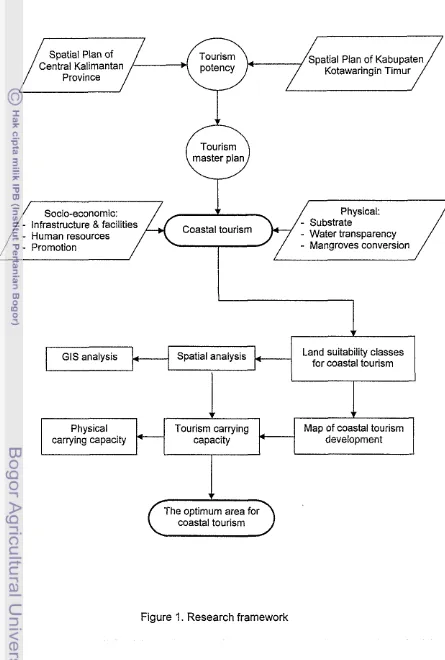
tourism activity and to avoid environmental degradation, it is therefore necessary to determine land suitability and the physical carrying capacity of the area as seen on Figure 1.
Objectives
The objectives of the study are:
a. To determine land suitability for coastal tourism development;
b. To estimate the physical carrying capacity for supporting coastal tourism activity; and
c. To determine the optimum area for coastal tourism in Kecamatan Teluk
Sampit.
Benefits
This study offers the following benefits:
a. It will be helpful for tourism planners and decision makers to manage coastal tourism activity; and
Spatial Plan of atial Plan of Kabupaten
Central Kalimantan Kotawaringin Timur
Province
Tourism
Socio-economic:
-
Infrastructure &facilities Coastal tourism-
Human resources-
Water transparency-
Mangroves conversionGIs analysis Spatial analysis Land suitability classes
for coastal tourism
coastal tourism
[image:18.564.74.519.105.765.2]C
t
Figure 1. Research framework Physical
carrying capacity
Tourism carrying Map of coastal tourism
LITERATURE REVIEW
Defining Coastal Areas and Coastal Tourism
Coastal areas are commonly defined as the interface or transition areas
between land and sea, including large inland lakes (FAO, 1998). Another definition about coastal area is the interface where the land meets the ocean,
encompassing shoreline environments as well as adjacent coastal water. Its components can include river delta, coastal plains, wetlands, beaches and dunes, reefs, mangrove forests, lagoons and other coastal features (Post and Lundin, 1996 in Zhang, 2001). A quit similar definition of coastal area according
to Bosch (2002), it is an area of earth surface, which includes land and water
areas, where interaction of the natural and social processes, determined by the impact of the land to the sea and sea to the land. Moreover, Arancibia (1999) pointed out to use a broader and more functional definition of coastal area whose
flexibility permits considerations of biological, biophysical, social, and economic aspects. It is defined as the geographic space in which the principal interchanges of material and energy are produced between the marine and terrestrial ecosystems.
Coastal areas are providing essential socio-economic and environmental benefits to humanity (Irtem et a/., 2005). The potential for social and economic
opportunities in coastal cities is a strong attractive force, fuelling immigration, often from economically depressed rural areas (FAO, 1998). Tourism is one of
sectors currently very dependent on coastal resources (Hourigan, 1998; Dahuri, 2003). It is extremely important to stimulate marginal economies and to promote development through the jobs and incomes for the social and economic welfare of current and future generations, as coastal resources support key economic
and subsistence activities (Liu and Wall, 2006). Coastal areas are also important
ecologically, as provide a number of environmental goods and services (Hourigan, 1998). Their location at the sea or land interface has recreational and aesthetic values which, in many countries, support valuable tourism activities, as well as provide attractive sites for industrial development and human settlements. Coastal tourism concept is emphasize in the full range of tourism, leisure,
normal home and workplace, the activities undertaken during they stay and the
facilities created to cater for the needs of tourists (Mathieson and Wall, 1982 in
Gunn, 1994). Coastal tourism is commonly known with 3 (three) S's that coastal area usually offer, includes: sun, sea, and sand (Wong, 1991). These include
coastal tourism development, such as: accommodation, restaurants, food industry, and second homes and its infrastructure such as: retail businesses,
marinas, and activity suppliers. It's also included all tourism activities such as: beach recreation, recreational boating, coastal and marine-based ecotourism cruises, swimming, recreational fishing, snorkeling, and diving (Wong, 1991; Cooper eta/., 1993; Hall, 2001).
According to Hall (2001), the development of management strategies for
coastal tourism is also needs to be understood in light of the nature of the management problem, the scale at which the problem is addressed, and the relative scope of intervention by government agencies. Planning for coastal tourism has usually focused on such activities, includes: land use zoning, site
development, accommodation and building regulations, the density of tourists, the presentation of cultural, historical and natural tourist features and also the
infrastructures. However, in recent years, coastal tourism has also emphasized on broader environmental and socio-cultural concerns, and the need to develop and promote economic development strategies at local, regional and national
scales, particularly within an increasingly globalize tourism environment.
G I s Applications in Coastal Tourism
Geographic Information Systems (GIs) is computer-based system that
provides the following four sets of capabilities to handle the input, data management, manipulation and analysis, and output of spatially referenced data
at different points in time (Aronoff, 1989; Malczewski, 2004). The most powerful characteristics of GIs are their ability to analyze spatial data based on descriptive attributes (Renger et a/., 2002) and visualizing the results.(Kalogirou, 2002). For example, by overlaying map layers with different attributes, GIs can be used to identify areas that meet specific criteria for each attribute. GIs can also be used
to help to eliminate data integration problems caused by the different geographic
analytical operations, into new information which can support decision-making
processes (Kent et a/., 1993).
GIs is now recognized widely as a valuable tool for managing, analyzing, and displaying large volumes of diverse relevant data to many local and regional
planning activities (Giles, 2003). Its use in environmental planning is rapidly increasing. Tourism is an activity highly dependent on environmental resources.
It has shown that coastal tourism planning can be enhanced by GIs applications.
GIs can be regarded as providing a toolbox of techniques and technologies of wide applicability to the achievement of sustainable coastal tourism development. Tourism destinations are usually characterized by three different landscape
features: points, lines, and polygons. Point features are individual tourist
attractions, for example, a campground in a park, or a historic site along the highway. Coastal beaches and resorts often follow a linear pattern, while big theme parks or natural parks are characteristics of a polygon feature. These location attributes are essential to a geographic information system. Tourism is a highly complex activity, and thus requires tools that aid in effective decision
making to come to terms with the competing economic, social, and environmental
demands of sustainable development.
Applications of GIs in coastal tourism planning illustrate that GIs is a strong and effective tool that can aid in tourism planning and decision-making. Integrated use of field surveys, remote sensing, and GIs in land use planning and
coastal tourism has been used and proven to be useful. For examples, to develop a prototype of coastal and marine tourism in Kupang, Indonesia
(Bakosurtanal, 1996), to provide spatial information for sustainable land use (Backhaus and Braun, 1998), coastal tourism planning in Ameland, Netherlands (Zhang, 2001), tourism spatial planning in the Black Sea Region (Bosch, 2002), use of GIs-based models for integrating and developing marine fish cages within
the tourism industry in Tenerife, Spain (Perez et a/., 2003), and the impact of urbanization and tourism on coastal environment (Burak et.al., 2004).
Sustainable Tourism Development and Tourism Carrying Capacity
The sustainable development of the coastal zone can be seen as a means of achieving harmony between the three elements including the reasonable use
keeping balancing of ecosystems and interrelated socio-economic systems resilient for avoiding irreversibility, and for keeping the level and impact of human activities within supportive and assimilative capacities (Khanna et a/., 1999).
Furthermore, similar definition from Weinstein and Ree (2005) that sustainable development is not only emphasize on ecologically sound but should also move
together toward integrated economically feasible and socially goals or norms. In the context of tourism, sustainability principles refer to the purpose of environmental, economic, and socio-cultural aspects of all tourism development that should be achieved (Clarke, 1997). According to McCool and Lime (2001) that the primary objective of sustainable tourism development is enhancing the
welfare of local community, through increased economic opportunity, preservation of the local community's cultural and natural heritage, and also to enhance the quality of life. In this sense, sustainable strategies look to identifying and managing acceptable or desirable social and biophysical conditions as the
output of tourism development. Furthermore, Johnson (2002) mentioned that tourism should also emphasize on sustainability principles by having regard for environmental carrying capacity, social responsibility and the integration of
tourism with local community wishes.
The suitable balance must be established between these three dimensions
to guarantee its long-term sustainability. Thus, to achieve sustainable all tourism development, not just coastal tourism, it should take an account of three interconnecting issues (Cater and Lowman, 1994; UNEP, 2002), as follows:
a. Make an optimal use of environmental resources that represent a key element in tourism development, maintaining essential ecological processes and helping to conserve natural heritage and biodiversity as an ecologically
sound;
b. Respect the socio-cultural traditions of host communities, conserve their built and living cultural heritage and traditional values, and contribute to inter- cultural understanding and tolerance;
c. Ensure ability, long-term economic operations, providing socio-economic
benefits to all stakeholders that are fairly distributed, including stable employment and income-earning opportunities and social services to host
The carrying capacity concept is based upon the assumption that there are
certain environmental thresholds which when exceeded can cause serious and irreversible damage to the natural environment or there are limits to resource use
for human activities (Wong, 1991; Cooper et a/., 1993; Clark, 1996). It is important to conceptualize the tourism carrying capacity, because the ability to express this in terms of an unambiguous standard measure is essential in order to facilitate tourism planning. However, there is a conceptual base for carrying capacity: social, economic and ecological. Almost all definitions incorporate in
two central elements: the behavioral component, it reflecting the quality of the recreational experience, and the biophysical component. In the coastal area, it is often applied to sustainability of the coastal tourism industry.
According to Canestrelli and Costa (1991), tourism carrying capacity is
defined as the maximum number of visitors that can be accommodated by a given destination under conditions of maximum stress, and the quality of their experience. Therefore, carrying capacity is the ultimate upper bound in the number of potential visitors in a resource-based attraction subsystem. It is also
defined as the maximum number of people that may visit a tourist destination at
the same time, without causing destruction of the physical, economic, and socio- cultural environment and an unacceptable decrease in the quality of the visitors
satisfaction (UNEP, 1997). Other definition from Saveriades (2000), that tourism carrying capacity is defined as threshold or tolerance level after which further exploitation or use may impose strains on the natural ecosystem and reflecting
the quality of the recreational experience. While, similar definition, according to
Pereira da Silva (2002), tourism carrying capacity is defined as the number of individuals a beach can physically accommodate. Therefore, the tourism carrying
capacity is also defined as the maximum number of people who can use a place without an unacceptable alteration in the physical environment and an unacceptable decline in the quality of the recreational experience (Simon et a/.,
MATERIALS AND METHODS
Study Area and Time Period
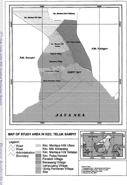
This study was carried out in Kecarnatan Teluk Sampit, Kabupaten Kotawaringin Tirnur, Central Kalirnantan Province from April to June 2006. It is
located in the southern part of Kabupaten Kotawaringin Timur, in front of Java
Sea (Figure 2). The distance of the study area from Sampit City is approximately of 87 krn and 306 km from Palangka Raya City. It is one of kecamatans in Kabupaten Kotawaringin Tirnur (from 13 kecamatans). It has an area of 610 krn2, and divided into 4 (four) villages, includes: Parebok (40 km2), Basawang (209 krn2), Larnpuyang (79 km2), and Ujung Pandaran (282 km2) villages (BPS, 2004).
Data Collection
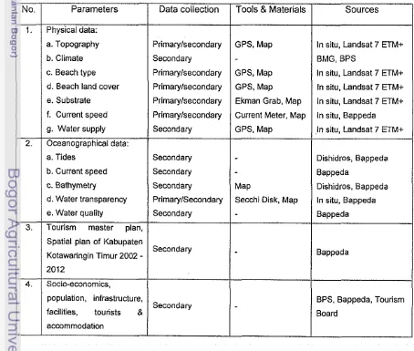
[image:24.564.74.528.367.752.2]Data and information was collected from primary and secondary sources Table 1 shows the data that was collected in this study.
Table 1. Data collection
I
i
a. Topography Primarylsecondary b. Climate Secondary No.I I
I I
c. Beach type Primarylsecondaryd. Beach land cover PrimaWsecondary 1.
/
/
e. SubstrateI
Primarylsecondary ParametersPhysical data:
f. Current speed Primarylsecondary
a. Tides Secondary Data collection
I
I
b. Current speedI
Secondaryi i
c. Bathymetry Secondaryd. Water transparency PrimaryISecondary
Spatial plan of Kabupaten
Secondary Kotawaringin Timur 2002
-
Socio-economics, e. Water quality
I
I
population, infrastructure,Secondary facilities, tourists 8
Secondary
I I
accommodationI
3./
Tourism master plan,I
Tools & Materials
GPS, Map GPS, Map GPS, Map Ekman Grab, Map Current Meter. Map GPS, Map
Map
Secchi Disk, Map
Sources
_____I
In situ, Landsat 7 ETM+BMG, BPS
In situ. Landsat 7 ETM+ In situ. Landsat 7 ETM+ in situ, Landsat 7 ETM+ in situ, Bappeda I n situ, Landsat 7 ETMc
Dishidros, Bappeda Bappeda
Dishidros. Bappeda In situ. Bappeda Bappeda
Bappeda
Kec. MB. Ketapang
Kec. Mentaya Hilir Selatan
I I
[image:25.564.87.498.91.687.2]Data Analysis
To fulfill the objectives of this study, the following data analyses were performed: (1) determining of land suitability classes for coastal tourism development using geographical information systems (GIs) analysis by employing ArcView version 3.2 software, (2) estimating of the physical carrying
capacity of coastal tourism was analyzed using the standards from WTO 1981 in Wong (1991), and (3) the optimum area for coastal tourism development was determined from analyzing the results from both GIs analysis and physical carrying capacity.
Land suitability classes of coastal tourism with GIs analysis
Land suitability is the fitness of a given type of land for a defined use. The process of land suitability classification is the appraisal and grouping of specific areas of land in terms of their suitability for defined uses (FAO, 1976). Land suitability expresses the acceptable levels of loss of matter and energy from the
land use system, as well as acceptable levels of input and of acceptable change in the status of the underlying land qualities (Beek et a/., 1997). Land suitability based on the concept of sustainability nearly always limits production potential, decisions on limiting the area of the land type taken into production and/or limits
temporal rotations. The GIs-based land suitability analysis in this research aims to identify the most appropriate spatial pattern for future land use according to
specific requirements, preferences, or predictors of activity applied in coastal tourism in Kecamatan Teluk Sampit.
Spatial data analysis for land suitability uses a GIs overlay from thematic maps. These maps are required for land suitability classes of costal tourism in
the study area. Next, each parameter is weighed and scored according to which criterion is the most important. The resulting suitability shows more and less suitable sites, according to the weights and scores indicated in this research and
ranked on the same scale as the ranked criterion. The result is classes of land suitability for coastal tourism in Kecamatan Teluk Sampit.
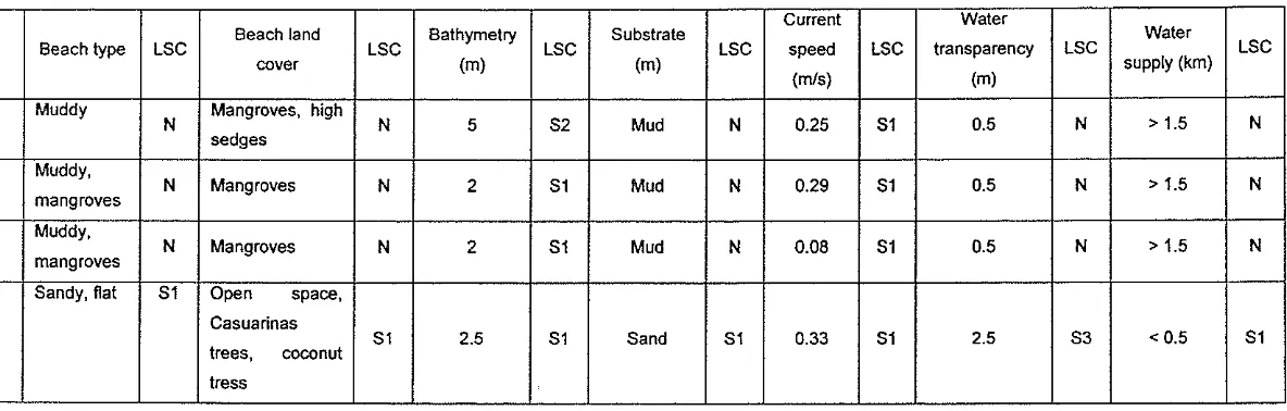
Some parameters obtained for land suitability classes of coastal tourism in this study, include: beach type, beach land cover, bathymetry, substrate, current
speed, water transparency, and water supply. These parameters are required as determining factors of the study area, and are selected based on conditions and
Physical condition of shallow water
Physical condition of shallow water in this study consists of: a. Bathymetry
Shallow water is the ideal location for recreation in the coastal area, and is necessary for the safety of tourists in their recreational use of coastal areas, such
as swimming. The ideal water depth for such activities ranges between 0 and 5 m with a flat sea bottom (< 25%). Tolerance for the area ranges from 5 to 10 m.
If the area is more than 10
m,
it is not suitable for water recreational activities.b. Substrate
Water substrate is a determining factor for clarity and turbidity of water in a coastal area. Sandy substrate is highly suitable for coastal tourism. Tolerance can be given for sandy and coral substrates, and also for sandy and muddy
substrates. If it contains muddy and coral substrates, the area is not suitable for coastal tourism activity, especially swimming.
c. Current speed
One of the limiting factors for coastal tourism activity, include: current speed. It is quite difference, which kind of coastal tourism activity that developer
or government needs to be developed or promoted, such as: surfing or
swimming. If they want to develop for recreational swimming, the current speed in that area should be lower than 1 mls. It is the highly suitable area for this kind
of activity. It can be tolerated for the area that has current speed range between 1.1 -2mls.
d. Water transparency
The most suitable measurement of water transparency for coastal tourism is
higher than 10 m. Tolerance can be given for an area that has clarity ranges
between 5 and 10 m, while an area is not suitable if it has a clarity of less than 1 m.
Physical condition of beach area
The physical condition of a beach area consists of the following parameters: a. Beach type
In this study, beach type is selected as a primary parameter because it will have a significant influence on visitor satisfaction. White sandy beach and a flat
activities are include picnicking, sun-bathing, sightseeing, beach sports, jogging, and camping. Tolerance can be given for an area that has a combination of sandy beach and coral beach, with a slightly sloped area or cliffs. Unsuitable
areas are those with muddy and coral beaches, mangroves, or steeply sloped beaches.
b. Beach land cover
Beach land cover in this study is also selected as a primary factor because
many tourists spend their leisure time sightseeing natural objects such as: coconut trees and sea-fir trees as beach land cover in the coastal area. These
beach land covers are the most suitable such activities; although tolerance can be given for an area having small sedges and grass cover, land cover is not suitable if the area is covered by mangrove forest, settlements, or ports.
d. Water supply
One factor that should be considered in coastal tourism activity is water
supply. The distance from the source of water could be handled by technology, so it is not a primary factor. The ideal distance from it source is less than 0.5 km.
More than 1.5 km is not ideal for coastal tourism activity.
These parameters are the basis input for matrices of coastal tourism land suitability classes. In this research, it's divided into four classes, as follows:
S1 (Highly Suitable) : Land having no significant limitations to sustained
application of a given use, or only minor limitations that will not significantly reduce productivity or
benefits and will not raise inputs above an acceptable level.
S2 (Moderately Suitable) : Land having limitations which in aggregate are
moderately severe for sustained application of a given use; the limitations will reduce productivity or benefits and increase required inputs to the extent that the overall advantage to be gained from the use. S3 (Marginally Suitable) : Land having limitations which in aggregate are
N (Not Suitable)
required inputs, that this expenditure will be only
marginally justified.
Land having limitations which appear so severe as to
prevent any possibilities of successful sustained use
of the land in the given manner.
Matrices of land suitability classes for coastal tourism are needed to help
determine suitability based on physical condition or characteristics. The purpose
is to minimize the risk in terms of sustainable land use. It is more important to
develop, because from those matrices the parameters and the result will be
known to determine land suitability classes of coastal tourism development in this
study area as seen on Table 2.
Table 2. Matrices of land suitability classes for coastal tourism
No.
1.
2.
..
---
(2002) in Soebagio (2004). Parameter
Beach type
Beach land cover
3. ( Bathymetry (m)
5.
/
Current speed (mls)I
< 1.01
1.0 -2.01
2.1 -3.01
> 3.0 6. ( Water transparency (m) ( 4 - 5 ( 2.9-
3.91
1.9 -2.91
< 1.9Finally, those parameters are weighed and scored to set the importance of
each criterion. The resulting land suitability classes show more and less suitable
sites, according to the weights and scores indicated in the study area. The
results of these matrices are classes of land suitability for coastal tourism
development in Kecamatan Teluk Sampit as seen on Table 3.
For example, a weight for beach type and land cover was set as the highest
value (10); it was higher than bathymetry (8). It was selected based on condition
that both beach type and land cover are major reasons for most of visitors to
enter into this coastal area. The combination of white sandy beach with
casuarinas trees (casuarinas equisetifolia) and coconut trees (cocos nucifera) is
directly related with visitors' satisfaction during their leisure time. 7.
1
Water supply (km)(Highly suitable)
sandy, flat
Open space, coconut trees, casuarinas
treec
4.
1
Substrate (%)I
SandI
Sand, coralI
Sand, mudI
Coral, mud 0 - 5Source: Modified from Bakosurtanal (1996) and KMN-LH-RI and FPIK-IPB
< 0.5
5 2
(Moderately suitable)
Sandy, coral
Grass, small sedges
0.5
-
11
1.1 -1.51
> 1.5-
5.1
-
10S-3 (Marginally suitable) Sandy, muddy, cliffs Forest
> 10
Table 3. The weight and score of land suitability classes for coastal tourism
Source: Modified from Bakosurtanal (1996) and KMN-LH-RI and FPIK-IPB (2002) in Soebagio (2004).
The result of land suitability classes for coastal tourism in Kecamatan Teluk
Sampit can be seen in Table 4, as follows:
Table 4. Scores of land suitability classes for coastal tourism
Tourism carrying capacity analysis
The carrying capacity concept in this research refers to the maximum level to which a particular location can accommodate tourists with high levels of satisfaction without causing destruction to the physical environment and to the
local community (Gu and Wong, 2004; Simon et a/., 2004). It is based on European and American experiences which have been modified to suit the ASEAN environment (WTO, 1981 in Wong, 1991). Even though coastal tourism
is still a new activity in this area, the carrying capacity approach can be useful
when the thresholds are identified ahead of time. No.
1.
2.
3.
4.
Land suitability classes
S1 (Highly Suitable)
S2 (Moderately Suitable)
S3 (Marginally Suitable)
N (Not Suitable)
Scores
The carrying capacities determined in this study include the preparation of site plans for new use sites and for authorized alterations of existing use sites;
also an estimate of the maximum number of visitors that can fit into that area. The standard physical carrying capacity of this study is divided into three categories, namely: beach capacity; accommodations (hotel); and infrastructure, such as: sewage disposal and water supply. These three factors are selected
mainly based on the observation and previous study to support coastal planning in Kecamatan Teluk Sampit (Table 5).
2. Accommodation (i.e. hotel or resort): a. Intensive development
[image:31.564.77.492.238.769.2]b. Limited development c. Preservation
Table 5. The physical carrying capacity of coastal tourism development
Parameter Unit
Bedroomslha 100 bedroomslha
60 bedroomslha 20 bedroomslha 1. Beach capacity (for resort excluding
facilities):
a. Low standard
b. Medium standardlseaside holiday c. Comfort
d Deluxe
Personlm of coast for 20
-
50 m of beach length2.0
-
5.0 1.5-
3.5 1.0-2.5 0.7-
1.51 I
Source: WTO (1981) in Wong (1991), Gu and Wong (2004). 3. Infrastructure:
a. Sewage disposal (no main system) b. Water (daily consumption per person)
When estimating the maximum number of visitors (m2person) that can physically fit into a defined costal tourism area over a particular time, the study used the
-
0.3 hall ,000 persons 500
-
1,000 literldayformulation from Bouilon (1985) in Soebagio (2004). It is assumed that the optimum area for intensive utilisation is not more than 10 % of the total area. The formulations are as follows:
Available area for public use (m2)
a. Physical carrying capacity (PCC)
=
---
Area required per user1A (m2)
Total time of utilisationlvisit (hour)
b. Rotation factor (Rf)
-
-
Average time of visits (hour)
To measure the PCC, the following assumptions have to considered:
-
PCC
-the area required by recreational users to undertake activities;-
A-
that the available area is determined by the particular conditions of the coastal tourism resources, and by limitations imposed due to fragility or as aresult of the need for safety precautions; and
-
Rf-
the rotation factor is the number of permissible daily visits to a coastal tourism area.The Optimum Area for Coastal Tourism Development
It was determined from analyzing the results from both GIs analysis and
physical carrying capacity. The result of highly suitable class (SI) and the standard of physical carrying capacity of beach area such for the beach capacity,
RESULT AND DISCUSSION
General Description of Study Area
Location
Kecamatan Teluk Sampit is located in the southern part of Kabupaten
Kotawaringin Timur, which spreads from latitude 2°50'00"
-
3"04'00" S and longitude 112°48'00" to 113~02'00" E. It has an area of 610 km2 and containsfour villages: Ujung Pandaran (282 kmz), Lampuyang (79 km2), Basawang (209 kmz) and Parebok Villages (40 kmz), respectively (BPS, 2004). Coastline
length within its territory is approximately 35 km. The boundary location of the study area is formed on its northern part by Kecamatan Mentaya Hilir Selatan;
on its southern part by Java Sea; on its western part by Kabupaten Seruyan; and eastern part by Kecamatan Pulau Hanaut. Figure 3 show the location of
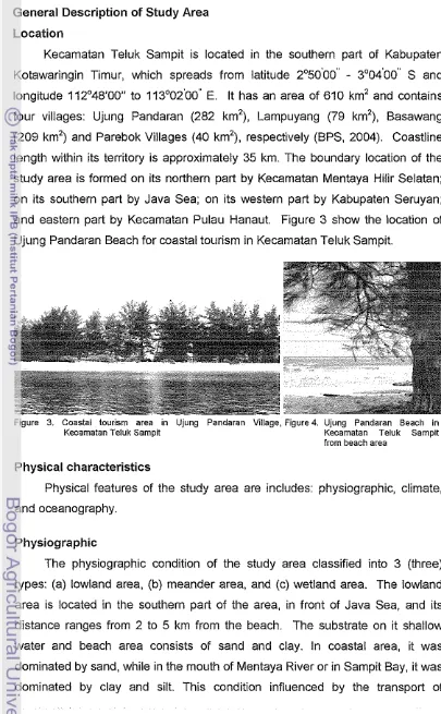
Ujung Pandaran Beach for coastal tourism in Kecamatan Teluk Sampit.
Figure 3. Coastal tourism area in Ujung Pandaran Village. Figured Ujung Pandaran Beach in
Kecamatan Teluk Sampit Kecamatan Teluk Sampit from beach area
Physical characteristics
Physical features of the study area are includes: physiographic, climate,
and oceanography.
Physiographic
The physiographic condition of the study area classified into 3 (three) types: (a) lowland area, (b) meander area, and (c) wetland area. The lowland area is located in the southern part of the area, in front of Java Sea, and its
distance ranges from 2 to 5 km from the beach. The substrate on it shallow water and beach area consists of sand and clay. In coastal area, it was dominated by sand, while in the mouth of Mentaya River or in Sampit Bay, it was
[image:33.559.77.482.94.749.2]sediment from Mentaya River. The meander area is slightly higher than the lowland area, but sometime it floods in the wet season (rainy day) which is
caused by discharge from the Mentaya River. Both lowland and meander areas
are influenced by tides. Third, the wetland area, situated behind the meander area, was formed by the result of organic matter from wetland forest that is trapped in that area. It can be found in the area surrounding the Mentaya River.
The elevations of the area range from 0 to 10 m (80,600 ha) and > 10 m (7,400 ha) above sea level, while its slope ranges from 0 to 2 % (about 96,357.86 ha) and from 2 to 15 % is about 5,887.77 ha (Bappeda, 2004).
Climate
Climate condition can not be separated from the influence of rainfall, air
temperature and humidity. These three factors, are connected with where, when and what kind of activities that visitors want to do, especially to spend their leisure in coastal areas.
I
1999 2000 2001 M 0 2 2003 2004I
Year! I
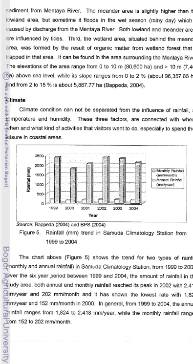
Source: Bappeda (2004) and BPS (2004)
Figure 5. Rainfall (mm) trend in Samuda Climatology Station from 1999 to 2004
The chart above (Figure 5) shows the trend for two types of rainfall
(monthly and annual rainfall) in Samuda Climatology Station, from 1999 to 2004. Over the six year period between 1999 and 2004, the amount of rainfall in the
study area, both annual and monthly rainfall reached its peak in 2002 with 2,418 mmlyear and 202 mmlmonth and it has shown the lowest rate with 1,824 mmlyear and 152 mmlmonth in 2000. In general, from 1999 to 2004, the annual
[image:34.559.76.471.46.791.2]The study area lies under the influence of seasonal monsoon winds. The
dry season starts from June to September and the wet season from October to May. The annual air temperature ranges from 21.6 to 33.2OC with the monthly temperature rates ranges from 25.9 to 27.7"C. The maximum monthly averages of air temperature range between 30.9 and 33.2'C, while the minimum monthly averages of air temperatue are range from 21.6 to 24.0°C. The monthly
humidity rates mostly range between 75.0 and 84.8% and the length of sunlight intensity ranges from 42.4 to 62.6%. Based on the climate types by Oldeman (1 977) in Bappeda (2004), the climate type of this area is 82. It means that the area has season divided into 2 (two) categories: wet month ranges between 7 and 9 months and dry month between 2 and 4 months.
Oceanography
Based on the tides estimation result from several stations in coastal waters
of Central Kalimantan Province by PPK-ITB in 2002 (Bappeda, 2004), the type of tides in Kecamatan Teluk Sampit is mixed tide prevailing diurnal. It means
that, in one day, there are two high tides and low tides that occured. The tidal
ranges (the difference in height between low tide and high tide) between 0.5
-
1.76 m, while the current speed is range from 0.01-
0.03 mls.Waves condition in the open water are mostly influenced by three factors: wind velocity, wind duration and fetch. In the study area, wave height ranges
between 1
-
2 m. Generally, it is influenced by east ad west monsoon. First the east monsoon, it has move from the east to the west along the coastline with 0,75-
1 m in height. Concerning the west monsoon, the wave is higher than the east monsoon with 0.75-
2 m in height and it direction moves from the west to the east.Water quality
quality for coastal tourism from Environmental Ministry Decree No.5112004 (KLH, 2005).
Turbidity is the extent to which light passing through water is reduced by scaterring induced by suspended and colloidal material. In this area, it value ranges between 5 to 405 NTU (Bappeda, 2004). This value is higher than the standard of water quality for coastal tourism from Environmental Ministry Decree No.5112004 (KLH, 2005), which is lower or equal with 5 NTU. This area is not recommended for recreational water use.
Biochemical Oxygen Demand (BOD) as the amount of oxygen (mgll) required by bacteria while stabilizing decomposible organic matter under aerobic conditions. In the study area, it has a value ranging from 0.54
-
3.50 mgll (Bappeda, 2004). It means that the area is suitable for recreational water use activity based on that standard of water quality for coastal tourism, which is lower than 10 mgll (KLH, 2005).Dissolved Oxygen (DO) in the study area was 6.05 in averages (Bappeda, 2004). Low levels of DO adversely affect the aquatic life, with the total absence leading to the development of anaerobic conditions with attendant esthetic problems. It can be seen that the study area is suitable for coastal tourism activity, because it was higher than 5 mgll as a standard of water quality (KLH, 2005).
The pH of most surface water range between 6 and 10. It means that the pH of some surface water in the study area was suitable and the other parts were not suitable for coastal tourism activity. The standard of water quality ranges from 7 to 8.5. The salinity ranges from 0
-
0.31 %o, while the totalsuspended solids (TSS) range from 0.081 to 0.166 mgll and a temperature range between 27" and 29,70°C (Bappeda, 2004). These conditions are related to the suitability of the area for supporting coastal tourism activity.
Socio-economic characteristics
Beside physical characteristics, socio-economics condition also have an
influence on coastal tourism development. Some of these factors describes in this study, such as: population, socio-economics and infrastructure.
Population
According to BPS (2004), the study area had 7.732 persons which
persons per km2. The total number of household was 1,514. From that total, during the year 2003
-
2004, all areas have had population increases with 3.05 %; 1.44 %; 0.44 % and 7.83 % in Ujung Pandaran, Lampuyang, Basawangand Parebok Villages, respectively. The highest population in 2004 was Lampuyang with 2,609 people, while Ujung Pandaran was the lowest with 1,049 people. The number of young people in between 7 and 12 year of age were
1,017, and from it total of 891 were school-age while 126 were not, which was
spread on 7 (seven) elementary schools in this area. From 2003 to 2004, the percentage of population rose with 2.70 %.
Socio-economics
Economic growth is an essential factor to support tourism development
(Cooper ef a/., 1993). Figure 6 shows the Regional Gross Domestic Product of Kabupaten Kotawaringin Timur, based on constant prices 1993, over the time period from 1994 to 2004.
Source: BPS, 2004 Years
I
Figure 6. Regional Gross Domestic Product (RGDP) of Kabupaten
Kotawaringin Timur from 1994 to 2004 (Rp. Thousand)
It can be seen from that figure, over the decade covered by the chart that Regional Gross Domestic Product (RGDP) has doubled from 1994 to 2004 to a peak of Rp. 203.3 billion. The chart also indicates that the year 1998 and 1999
recorded declining RGDP. This was not surprising, because at the time the Indonesian economy was undergoing an economic recession. After that, it grew
I
[image:38.582.90.464.71.248.2]/source: BPS, 2004 Years
I
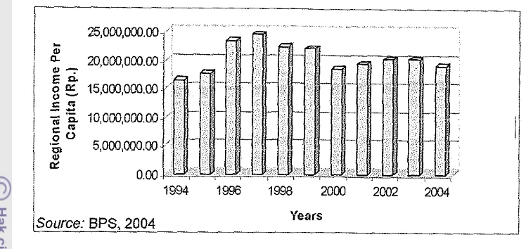
Figure 7. Regional income per capita of Kabupaten Kotawaringin Timur from 1994 to 2004 (Rp.)
Figure 7 shows the trend of regional income per capita from the period 1994 to 2004. After it increased strongly from 1994 to 1997 with Rp.
16,525,748.90,- and Rp. 24,530,268.80,- respectively, it declined from the years
1998 to 2000 of around 18%. The figures also indicate fluctuating trends from 2001 to 2004. Overall, the year 1997 showed the highest rate of regional income per capita in this area with Rp. 24,530,268.80,- while the year 1994 was
the lowest with Rp 16,525,748.90,-.
It is clear from Figure 7 that regional income per capita in the regional context was high. It might be useful as an input to support coastal tourism
development.
According to Bappeda (2004), in 2003, most of local population's occupations were fishermen and farmers. In Ujung Pandaran Village, 95 %
were fishermen, in Lampuyang Village most were farmers in brackish ponds;
while in Basawang and Parebok Villages many were farmers in the coconut plantation sub sector (Bappeda, 2004). By origin, the residents of Kecamatan
Teluk Sampit came from Banjarmasin, South Kalimantan Province who moved to work as fishers, and their religion is 100% Moslem which was supported by 9 mosques and 14 prayer houses for their daily religion activities. This condition
will likely have an influence on coastal tourism activities, especially for cultural tourism.
The expectation in Kabupaten Kotawaringin Timur is that tourism that can generate income for local people through a communiiy based development and
a. Tourism development based on the natural setting and culture of the local
community;
b. Village tourism that can support local community livelihood; and
c. Tourism that is also supported by agricultural, small scale industry, services, and marine or river activities.
Tourism potencies in the study area are divided in 4 (four) categories:
natural tourism (Ujung Pandaran Beach), cultural tourism (fishermen village in Ujung Pandaran Village), agro-tourism (coconut trees in all of the villages), and
man-made tourism (small scale fish product industry). It is also supported by local beach arts (cultural tourism), such as: burdah, hadrah, tirik jepen, and
sloka. These activities are usually celebrated during wedding parties or harvests (Bappeda, 2004).
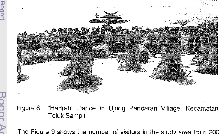
The Figure 8 below shows an example of cultural tourism that is called the "Hadrah Dance. This event is held in Ujung Pandaran Beach, usually for giving
thanks to God after harvest time. It will attract more visitors if managed well and
combined with coastal tourism in this area.
Figure 8. "Hadrah" Dance in Ujung Pandaran Village, Kecamatan Teluk Sampit
The Figure 9 shows the number of visitors in the study area from 2003 to 2005. Over the three year period, the number of domestic and foreign visitors has increased. The highest number of visitors occurred in 2005, with 2,495
[image:39.573.86.463.399.629.2]that number of visitors is still low. More effort is needed to support this area as a
coastal tourism area so it can attract more visitors.
2500 2000 1500
1000 m Donest8o Tourists
500 0
2003 2004 2005
Years
Source: BPS, 2005
Figure 9. Number of visitors in Kecarnatan Teluk Sampit from 2003 to 2005
Infrastructures
Transportation is the most important factor that should be planed and
developed for coastal tourism activities in this area. This area can be reached
by two modes of transportation: roads and rivers. From Sampit City, road travel
time is about 1.5 hours. In 2004, the total length of roads was 54.5 km. Road
conditions are divided into three categories, namely: hot mix (7 km); gravel
(35.75 kiii); and local road (11.75 km). There is only one of post office branch,
but it was supported by a telecommuni~ation station of lndosat. Tourists usually
will keep in touch and give information on their condition to their family or friends
when they have already came in tourism destination area; thus it is an
advantage to have a telecommunication station that can support the tourism
industry.
The water supply is usually fulfilled by pump wells. It was used by 426
households; as opposesd to rivers and lakes by 228 households and other
sources by 860 households. There was no households using water supply fro%
the local government (PDAM), because it still a new area that was established in
2004. The local government has planned to establish a water supply in 2007
which should be sufficient not just for the local population but also for coastal
tourism development in this area. Electricity was available to 281 households,
and kerosene was used by 1,182 households from 'I ,524 households in the tots\
There are no accommodations, such hotels or resort, or restaurant or souvenir shops for visitors in the study area; they were staying in Sampit City to spend their night. The development of such facilities should be considered by the local government to attract more visitors.
Spatial Analysis for Coastal Tourism i n Kecamatan Teluk Sampit
A Geographical Information System (GIs) analysis was used to determine the suitability classes for coastal tourism in Kecamatan Teluk Sampit. In the
study area, coastal tourism activities commonly include: beach recreations such as: picnicking, sun-bathing, sight seeing, beach sports, and recreational water use. The land suitability classes for coastal tourism in this area were divided in
3 (three) categories: highly suitable (SI) class, marginally suitable (S3) class, and not suitable (N) class, respectively. There was no moderately suitable (52)
class for coastal tourism development. For detail, the result of each land suitability classes will be describeded, as follows:
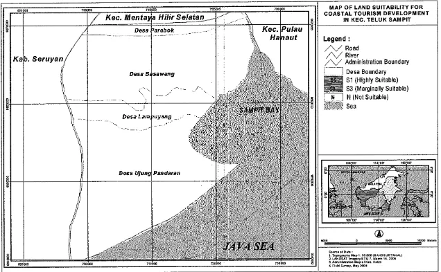
Highly suitable (St) class
The highly suitable (Sl) class for coastal tourism development in the study area is located in Ujung Pandaran Village; it has an area of 52.23 ha and also is
about 200 m wide as a coastline buffer is suitable for recreational water use, such as: swimming. It was developed considering the environmental condition
and the safety of the visitors on the beach area (Soebagio, 2004). This area has virtually all of the criteria for suitability, although one of the seven parameter of suitability was found to be marginally suitable (S3); but in total, the area was
classified in highly suitable (SI). The parameter that was marginally suitable (S3) was water transparency, with it scoie of 6. On the other hand, six parameters achieved the highest scores (SI) with 20, 18, 14, 14, 12 and 10 for the beach type, beach land cover, bathymetry, substrate, current speed, and
water supply respectively. In total score, the area was classified on highly suitable (SI) with a score of 94 (Table 7).
Not surprisingly, that Ujung Pandaran Village has the highest score for its suitability. This is supported by factors, such as white sandy beaches along 35 km its coastline, as well as the casuarina trees (casuarinas equisetifolia) and
lower than 0.5 km, These factors have made this study area available for
coastal tourism development, as the land has no significant limitations to sustained application of coastal tourism. The only minor limitation that will not significantly reduce productivity or benefits of the study area was water transparency. According to Bakosurtanal (1996), this factor cannot be changed to increase its value, because it was a permanent factor. The difference this
study result and Bakosurtanal (1996) is the land suitability classes for the water transparency. The condition of the water area between Kalimantan Island and Nusa Tenggara Tirnur is different. Commonly, in the Kalimantan Island, water
transparency is poor; it was influenced by transport of sediment from some big rivers. Furthermore, the modification of this parameter is needed to get the suitability balance or the proportional condition, based on the real condition on each study area.
From that result, this area is recommended for beach recreation, such as: picnicking, sun-bathing, beach sports (jogging), and sight seeing, and
swimming, even the water transparency was lower than 5 m. It is influenced by land-based activities that result in the transport of sediment from the Mentaya
River. As a consequence, water transparency in the study area is typically not more than 1.5 meter. In addition, this area also recommended as a recreational cruise area, such: boating (Johnson, 2002), it was supported by the current speed that was lower than I mls. According to Bhatt (1978), it can be classified
in calm condition with the characteristic of sea water like a mirror. Thus combination of tourism objects would be optimal, if it supported by the good
tourism promotion by the local government. In recent year, to develop the area for coastal tourism destination, it is not only physical factors but also the safety of tourism area or environment condition that will be important
-
such as no dangerous animals, the security of the area, and low risk of natural disasters, such: land slide, earthquake, and tsunami (Yulianda, 2004). Ujung PandaranBeach provides thus advantages.
Marginally suitable (S3) class
Total area of this marginally suitable class was 279.79 ha, located in Ujung Pandaran Beach, will be only marginally justified for tourism development. The limiting factors found, such as the elevation of the area is more than 3 m,
and accessibility (roads) is more than 0.5 km. These limiting factors,
consequently, will reduce the benefit and productivity of the area, and increase the input if developed as a coastal tourism destination area (FAO, 1976;
Bakosurtanal, 1996; and Soebagio, 2004). The advantage factors were bathymetry (2 m), the current speed (0.33 m/s), and sand substrate on the shallow water area. From that result, this area is also recommended for beach
recreation (i.e. picnicking, sun-bathing, beach sports, sight seeing), swimming and boating. But, still it needs more input to develop this area as a coastal
tourism area. For example, to attract more visitors to visit this area, the local government or private should planting the coconut trees or casuarinas trees to make the area green and more comfortable. This action has already implemented in the western part of beach area.
Not suitable (N) class
The area that was not suitable for coastal tourism incorporates:
Lampuyang, Basawang, and Parebok Villages, covering an area of 60,667.98
ha. The limitations of this area are significant enough as to prevent any possibility of successful sustained use of the land as a coastal tourism area. The limiting factors being: beach type, beach land cover, substrate, water transparency, and water supply. Only bathymetry and current speed was
considered to be above the non suitable classification. In general, these village areas were grouped as a non suitable area (N) with total score of 34; 34 and,
30, respectively, due to the total score of the land suitability classes were lower than 35. It is clear that those areas were not suitable to develop as a coastal
tourism activities area. But, it can be recommended for developed the accommodations such hotels or resorts, and also the tourism facilities if
considered the limited highly suitable (SI) area for coastal tourism development. In general, in this study area, the land suitability classes for coastal tourism
development were classified into 3 (three) classes: highly suitable (SI), marginally suitable (S3), and not suitable (N). There is no moderately suitable (S2) class. This condition was influenced by the weighting of beach type and
land cover with each score of 10. As a result, white sandy beaches along 35 km its coastline and casuarianas and coconut trees were performed the land
Table 6. Matrices of land suitability classes for coastal tourism in Kecamatan Teluk Sampit
Table 7. Score of land suitability classes for coastal tourism in Kecamatan Teluk Sampit
Water
Bathymetry Substrate Current speed Water supply
[image:44.797.141.733.102.291.2]Carrying capacity for coastal tourism in Kecamatan Teluk Sampit
There are three parameters to measure the carrying capacity for coastal tourism activities in this area, include: (1) beach capacity (for resort excluding facilities), (2) accommodation (hotels or resorts), and (3) infrastructures (waste disposal and water supply). Thus parameters are using the standard of physical carrying capacity from WTO 1981 (Wong, 1991). For detail, the result
for each parameter describes as follows:
Beach capacity
The limiting factor for beach capacity is length of white sandy beach that is usually used by tourists for their coastal tourism activities. In Kecamatan Teluk Sampit the length of white sandy beach was about 5.25 km or 5,250 m. From
the standard of physical carrying capacity by WTO 1981 (Wong, 1991) for beach capacity, it is divided into 4 (four) categories, namely: low, medium, comfort and
deluxe standards.
The beach carrying capacity for low standard is 525 persons per day, 394
persons per day for medium standard, and 263 persons per day for comfort, while for deluxe is 184 persons per day. In terms of annual carrying capacity, it is assumed that the area is open for 240 days per year for coastal tourism
activities. In this context the beach capacities for low standard were 126,000 people, medium standard 94,560 people, comfort 63,120 people, and deluxe 44,160 people (Table 8). The carrying capacity of a beach area to accept the
number of visitors in one year cannot exceed the maximum capacity for each category.
In general, the ability of beach capacity to accept the maximum number of daily or annually visitors was lower than the standard of physical carrying capacity in all classes. As a comparison, from 2003 to 2005, the daily average number of visitors was 6 people; while it annually it was 193 people. Thus both Table 8. The beach carrying capacity in Kecamatan Teluk Sampi;
Beach capacity a. Low
b. Medium c. Comfort
d. Deluxe
numbers of visitors in the study area were lower than standard. This is not
surprising, given the lack of infrastructure and facilities to support the area as a coastal tourism area.
Accommodations (hotel or resort)
In the Kotawaringin Timur Spatial Plan, no specific mention is made about the total allocation area for coastal tourism activities. From GIs analysis, the
marginally suitable (53) area available for coastal tourism development is about 279.79 ha. According to Zhang (2001), this area can be recommended for
accommodation development such as hotels or resorts. The most suitable (SI) area for coastal tourism consists of 52.23 ha. To provide enough space for
visitors without reducing the size of the S1 area, developing the marginally
suitable (S3) area having area of 279.79 ha is recommended. It is assumed that the allocation area for accommodations is only 1.5 % of the total area (to consider the sustainability of the area), so its allocation was about 4.20 ha. The
allocation area to establish the accommodation is divided by its capacity into three classes: economy, average and luxury.
The carrying capacity of the accommodation (hotel) for economy class was 4,200 people; average class was 2,211 people; and luxury class was 1,400 people. The carrying capacity of the beach area to establish the accommodations cannot exceed the maximum capacity for each class.
In Kotawaringin Timur Spatial Plan, it is not mentioned explicitly about total allocation area for coastal tourism activities yet. From GIs analysis, it was found that the area that is located in set back of highly suitable area is available for coastal tourism development. According to Wong (1991), to keep the
environment sustains, the site selection is needed consider with the various parts of the coastal environment condition (hinterlands, beach, and sea) and specific aspects of the tourism system (accommodation and service, transit, and recreation activity). Based on that description, the set back area that is located
200 m behind the beach area is suitable