RIVER AREA MANAGEMENT IN SOLO CITY, INDONESIA
between the original river channel and river embankments enabled to accommodate river discharge exceeds the capacity of the original river channel. In urban areas, due to the demand for land for residential housing is quite high, there are many dense illegal residential along the urban river, although the regulations prohibiting it. Problems occur when the flood come, because the reducing capacity of the rivers and many occupancies attacked by floods. River area management should be applied to overcome this problem including flood- plain management is enabled for a public area and when flood came, flood flow is not blocked and there is no so big damage. Such management carried-out on the flood-plain of the Solo River in Kampung Sewu, PucangSawit, Solo.Kewords: River Area Management, Urban River, River Channel, Flood Plain Area, Solo River.
INTRODUCTION
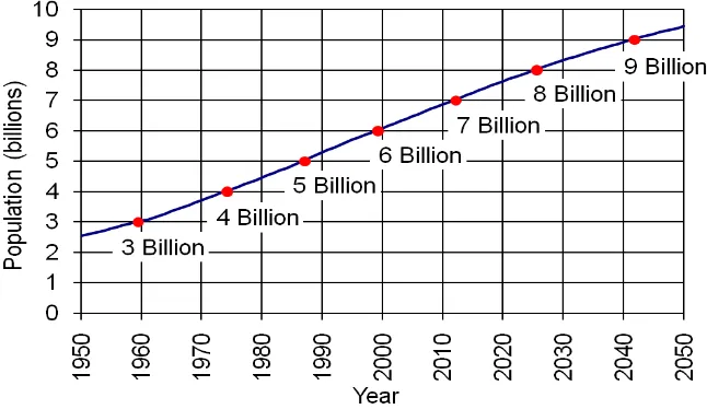
The world’s population is very high. Based on United State of Census Bureau (USCB), the world
population has now reached more than 7 billion people. According to the United Nations (2012), the 7th
billion baby was born on October 31, 2011. Figure-1 shows a graph of world population growth since
1950 and forecasts up to 2050.
Figure-1 World Population 1950-2050 according USCB, 2011
Since 1950 there has been a huge worldwide increase in the percentage of population living within cities. The trend shows no sign of stopping - for the next 20 years, the flow of people is predicted to continue soaring. Figure-2 shows the world cities exceeding 5 million residents in 1950, whereas figure-3 shows the predicted world cities exceeding 5 million residents in 2050.
Figure-2 : Theworld cities exceeding5 million residents in1950
Figure-3: Theworld cities exceeding5 million residents in1950
(www.fws.gov)
Figure-4: Floodplain area in river cross-section
Figure-5:Illegal housing alongCitarumRiver, Jakarta
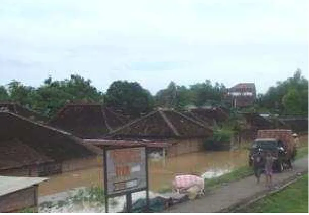
The problem occurs when flood come. In the rainy season, the river discharge increase and exceed the river channel capacity, then river flow will inundate the floodplain area and attack the housing located in. In addition, the river flow is blocked by those houses and will lead higher flood magnitude. Figure-6 shows the houses located in the floodplain area in Solo River were attacked by flood in 2007.
Figure-6 :Flood attackedhousinglocated infloodplain area
River area management should be applied to overcome this problem including flood-plain management is enabled for a public area and when flood came, flood flow is not blocked and there is no so big damage. Such management carried-out on the flood-plain of the Solo River in Kampung Sewu, PucangSawit, Solo.
THE BASIC PHILOSOPHY OF RIVER AREA MANAGEMENT
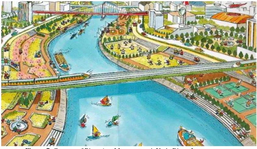
surrounding community will always maintain the floodplain area. When flood come, there is not so much loss and damage, and recovery can be done easily and not costly. Figure-7 shows the concept of River Area Management in Yodo River, Japan. The figure shows the floodplain area of the Yodo River used for the many kind of sport and other activities that are beneficial, but do not result in huge losses or damages
if the flood comes
.
Figure-7: Concept of River AreaManagement inYodo River, Japan
River Area Management Pilot Project in Pucang Sawit, Solo.
As a one of the cities traversed by the Bengawan Solo, Surakarta is exposed to various risks due to the Bengawan Solo’s inundation. Floods frequently happen in the city and its impact to urban sustainability such as interruption of transportation system, and environmental degradation as well as a setback to people livelihood have to solve systematically by involving all stakeholder capacity.
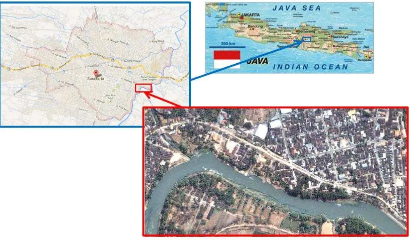
Pucang Sawit is one of settlement area on the riverbank of Bengawan Solo (see figure-8). The people of Pucang Sawit has been reside in the area gradually since before the government develop the dike of Bengawan Solo in the 70’s. Because of its location inside the dike and the worsening condition of the River basin of Solo, this community have to go through flood and other disaster related to the condition of the river. The Municipality of Surakarta has planned to develop a pilot resettlement and urban forest project in Pucang Sawit starting from 2007, on 2008 - 2009 a process of 198 household facilitated by the municipality and the Coordination Ministry of welfare to resettling the community in two areas namely Solo Elok and Pipitan.
In line with the municipality effort, the Ministry of Public Works plan to expand the function of the Dike as a joint programme with the municipality, and adjust the riverbank to fulfil the river technical function requirement. The question than, how the land ex-settlement of Pucang Sawit could be adapted to the river technical requirement but at the same time become the urban green – open space function as require by the spatial law? At the same time a question arise how the local government replicate this pilot project to the rest of 38 Ha of Riverbank in the city and to what extent the stakeholder could contribute to the initiation, and operation of this new green – open space of Solo?
Page-179 Figure-8: Map of Pucang Sawit, Solo
To support the inspiration of Solo municipality, a pilot project cooperation of the State Ministry of Public Housing, the Centre for Urban Development Study, and the Asia Carbon Ltd, Singapore, initiated a pilot project of stakeholder capacity building on urban resettlement and environment planning. The program consists of discussion, workshop and guidance to accelerate and improve the Pucang Sawit, Solo project. As the research institute in the field of water resources and has competency in river conservation and restoration, then Research Centre for Water Resources (RCWR) in Bandung invited by the Solo Municipality to give technical assistance in utilization of flood channel area ex-settlement towards urban forest / green open – space considering the river area management. RCWR then command the Experimental Station for Rivers in Solo as RCWR representative, to involve the team work of pilot project cooperation in order to follow the process as well as discussion and give some suggestions considering the regulation and technical / hydraulic aspect in the context of river area management principles.
Related to the scope of services by Dissemination Unit for Water Resources Management (DUWRMT), a part of Pucang Sawit flood channel area then consider selected as pilot project activity in the field of river area management synergy with the similar pilot project by Solo Municipality.
River area management Pilot Project here was not just only building some infrastructures for make better condition of river environment, but also consider for both the function of river environment condition in
proper state and regulation of river area management as regard with the policy, both
technical/hydraulic/hydrology and non technical aspects.
The field study in the scope of river area management should be adopted and take into account for consideration in planning process for green open-space in all season both rainy and dry seasons combine with sport facility such kind of volley ball field and children playing facility. The pilot project applied the concept of Green Open-Space, Sport and Public Facility Planning / Design and Discussion : assessment of river characteristic (river morphologic, river hydraulic, river environment, etc), kind of plants appropriate, planning and design of sport facility ( volley ball court, table tennis court), jogging track, children playing area, and River Calendar Monument/ Flood Events Monument.
Page-180
Figure-9:Lay-out ofRiver AreaManagement at PucangSawit.
In the implementation phase of the work, the surrounding community was very keen to be involved directly as a workforce. It is actually highly desirable, psychologically they would feel help build and maintain (see figure-10). It also fostered a sense of belonging necessary infrastructure so that they/community beneficiaries participate directly responsible for his care.
Figure-10: Communityparticipation in this pilotproject
Page-181
The outputs of this pilot project are:
a. Assessment on Pilot Project Activity which is closely related to PDM / Modules and Guidelines,
including exclusive use of river area appropriate with the regulations (Law of Water Resources, Minister Decree Concerning River Area, Local Government Regulations, Law of Spatial Space, etc)
b. Public facility infrastructures (green open space, sport facilities such as volley ball field, children
playing) in line with the rule of river area management.
c. Hydraulic/hydrology assessment based on historical flood events: discharge – water level that
inundates the flood channel area from 2000 – 2010. For the range of facilities particularly for
providing simple flood information warning system, such kind of River Calendar DUWRMT
Monument will be build in the field.
Figure-11 shows the result of River Area Management Pilot Project in Pucang Sawit.
CONCLUSION
River Management Area in Pucang Sawit, Solo is an activity to restore floodplain function as a place for the flood flow, so it should be free of distractions such as illegal housing and replaced with green open space which can be utilized for various purposes.
Physically the contribution of pilot project in Pucang Sawit flood channel of Bengawan Solo river is seem as just building some facilities in river area, but in the wide scope, that infrastructure has comprehensive aspects in the rule of river area management such as:
a. keep and guard river environment from pollution, garbage dump and mainly to protect from illegal slum
b. managed properly the river flows in flood times that inundated flood channel or in low flow state from water pollution
c. in regard with regulation concerning prohibited and permissible activities
d. public participation and society awareness to keep the conservation and probable to take advantages from sport & recreation facilities
The activity of pilot project will involve planned initiatives on river area assessment and improvement, river amenity, stakeholder’s agreement reached in managing that area, eco cultural domestic tourism opportunities, stakeholder’s commitment, public engagement; constraint and solutions, monitoring and evaluation.
The success story of this project can be shared for implementation to the others places.
References:
Andras Szollosi-Nagy, 2011, “Out of the Blue: Choices for a Sustainable Planet after Rio+20” , Presentation on ADB Water Learning Week.
Balai Besar Wilayah Sungai Pompengan Jeneberang, 2007, “Guideline on Interagency Coordination for Management of River Area in the Jeneberang River”.
Dissemination Unit of Water Resources Management, 2010, “Modul Pelatihan Penataan Area Sungai”. Isnugroho and Rahardjanto, 2012, “Penataan Bantaran di Kota Solo menuju Waterfront City”,
Presentation on National Seminar and Workshop on Urban River, Solo October 2012.
Rahardjanto, 2011,”Final Reportof Pilot Activity on River Area Management in Pucang Sawit Flood Channel Area of Bengawan Solo River, Eastern Part of Solo City”, Capacity Development Project for River Basin Organizations in Practical Water Resources Management and Technology.
Rahardjanto, 2011, “Pilot Activity of River Area Management”, Presentation on Wrap Up Meeting of DUWRMT, July 2011.