Land Use Optimization for Sugarcane Plantations
in Eastern Seram District, Indonesia
Prima Jiwa Osly
1*, Widiatmaka
2, Bambang Pramudya
3and Komarsa Gandasamita
21
Graduate School of Natural Resources and Environmental Management, Bogor Agricultural University, Rektorat Building 5thFloor, Kampus IPB Darmaga, Bogor 16680, Indonesia
2Lecturer of Soil Science and Land Resources Department,
Faculty of Agriculture, Bogor Agricultural University
3Professor of Department of Agroindustrial Technology, Faculty of Agricultural
Engineering and Technology, Bogor Agricultural University
Land use optimization for agriculture is an attempt to increase the utilization of land resources by matching agricultural land with the most productive crop to both expand the plantable area and maximize productivity. The expansion of the cultivated area is actively occurring in the eastern Indonesian, region of East Seram, Maluku Province. One of the prospective commodity crop planned for the region is sugarcane (Saccharumspp.). The method used for evaluating land for determining optimal land use is land suitability analysis, a combination of multi-criteria decision making and GIS mapping. We used multi-criteria decision making to identify the optimal area for sugarcane plantations and sugar industries, using criteria to identify land suitable for sugarcane growing in three suitability classes, very suitable, suitable and unsuitable, subject to achieving economic viability for a sugar mill. Mill viability was based on the ability of the planted area to support at least a minimum number of cane milling days per years (150/y), and a daily production target of ≥8,000 tonnes cane crushed per day (TCD). In East Seram district our analysis of a selected 206,235 ha are identified 34,894 ha in suitability classes highly suitable, moderately suitable and marginally suitable. The identified optimal area was estimated to be capable of producing 2, 119, 424 tonnes of sugarcane per year, yielding a mill productivity of 14,129 TCD over the crushing season, thus indicating strong economic viability for a single mill but possibly not for two mills.
Key words: Land optimization, land suitability, land use, East Seram District
───────────────────────
1. Introduction
Land optimization is an exercise that attempt to find the optimum land for potential use based on specific criteria and is important step in detecting production and environmental constraints in land use planning (Bandyopadhyay et al., 2009). The potential of an area for a particular type of agricultural development is determined by matching the physical characteristic of the land with the requirements of that agricultural activity (Marthen et al., 2010). Appropriate land use decisions are vital to achieve optimum productivity of
the land and to ensure environmental sustainability. This requires effective management of the spatial information for the land on which the decisions will be based (Bajaet al., 2011). Optimization of land use is an attempt to maximize the value of production from land resources by allocating land to the use or uses to which it is best suited, whether commercial, industrial crop, horticulture, plantations, livestock, or conser-vation, amongst others. The optimization of agricul-tural activities is geared to meet the criteria for crops, horticulture, plantations and livestock with respect to technical and infrastructure requirements. Land
opti-Received: September 17, 2013, Accepted: January 22, 2014
* Corresponding author: Graduate School of Natural Resources and Environmental Management, Bogor Agricultural University, Bogor 16680, Indonesia.
mization can be done by utilizing the idle land into productive farmland and increasing cropping index. Land optimization can be performed by undertaking land suitability assessment for particular commodities that could be planted on an agricultural area (Wandahwa and van Ranst, 1996; Bojorquez-Tapiaet al., 2001; Boonyanuphapet al., 2004; Hossain et al., 2007; Pradanaet al., 2013).
The purpose of this study was to analyze the optimal land for sugarcane in East Seram, eastern Indonesia, an area that is currently of interest to many investors.
2. Sugarcane and eastern Indonesian region
Sugarcane (Saccharum spp.) is an agro-industrial crop with a very high economic value, because of sugar’s widespread use by consumers and in food manufacturing. Sugar consumption is increasing steadily in Indonesia because of population growth, increasing wealth, and increased demand from indus-try. Currently, Indonesia is only 60% self-sufficient in sugar, with remaining demand met by imports from Thailand, Brazil, Australia, El Salvador and Guatemala (BPS, 2011).
Eastern Indonesia still holds considerable potential for agricultural expansion. The province of Maluku, comprising a group of island, has substantial unde-veloped land resources. Maluku Province has two major islands, Seram and Buru, and the Climate of the region is tropical. The Rainfall pattern in Maluku is similar to that Papua Province where sugarcane was first domesticated around 6000 BC (James, 2004).
Eastern Seram District (SBT) in Maluku is a new district founded in 2003. Lack of attention by provincial and local governments to investment in mining, plantations, and forestry in this region has been low, 80% of the land with potential for plantation crops has not been planted or lies dormant (Oslyet al., 2012). The SBT District Spatial Plan 2008-2028 includes a strategy to accelerate the economic devel-opment of the region through the key sectors of plantations, fisheries and mining (Anonymous, 2012). Soil surveys conducted by the Land Research Center (PPT, 1985) and the Soil and Agro-climate Research Center (PUSLITANAK, 1996) also indicate that conditions on SBT are widely suitable for sugarcane plantations.
3. Materials and Methods
3.1 Study Area
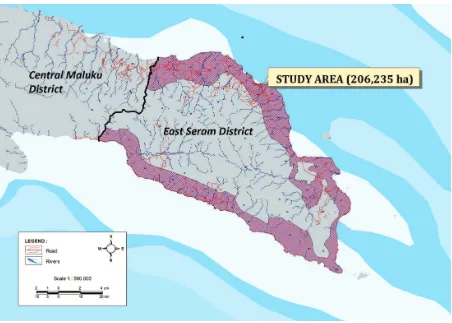
The study area of East Seram district in Maluku Province (Fig. 1) is bordered by the Seram Sea to the north, the Banda Sea to the south, the Arafura Sea to the east and Central Maluku district to the west. The total land area of East Seram district is 5,779,123 km2 (BPS, 2009). The study area’s tropical maritime cli-mate has a high annual rainfall distributed throughout the year. The average annual rainfall is 2,172 mm (BPS, 2009). The average number of rain days per month is between 11 and 18 days, with an annual average of 15 days per month. The study area is in the agro-climatic zone C-1 and rain type A (Oldeman et al., 1980). Five month of the year are regarded as ‘wet’ (≥200 mm) and one month is regarded as ‘dry’ (<100 mm).
The analysis was conducted on land within the study area with a land zoning status that permits plantation agriculture of a total area of 206,235 ha (Fig. 1). Landsat TM +5 band 543 Path 107/Row 62 image
acquisition March 9, 2008; April 26, 2008; April 22, 2009; November 23, 2009 and January 28, 2010 (Anonymous, 2010), were interpreted referring to the 1:50,000 RBI (Rupa Bumi Indonesia/Topographic maps Indonesia) sheet 2713-13, 2713-32, 2712-61 to 2712-64, 2812-41 to 2812-43, 2712-33 to 2712-34 and 2812-11 to 2812-14 (collected from Geospatial Infor-mation Bureau). Maps and secondary data used in-clude 1:250,000 maps Land Unit Seram Island in 2008. Contour maps C intervals of 5 m and 12.5 m from the Digital Elevation Model were interpreted from SRTM Data (Anonymous, 2009), climate data (collected from Geser Station of Climate and Geophysics Bureau) and geological maps of the island of Seram 1:250,000 sheet Bula and Watubela (Gafoeret al., 1993).
Field survey conducted in the study area from July 2010 to August 2010. Laboratory analysis was con-ducted in August 2010 until November 2010. Pa-rameters tested were soil texture, pH (H20 and KCl),
organicmaterials, P2O5(Olsen and Bray 1) and NH4.
Spatial analysis was done using ESRI’s ArcView software version 3.30 and Global Mapper version 11.20.
3.2 Method of Land Suitability Assessment
Land suitability analysis was conducted by the method of “matching” (i.e., by comparing the
char-J. Dev. Sus. Agr. 9 (2)
acteristics of the soil with the requirements of sugarcane for each land unit). This valuation method is used to identify mapping units with the right suitability index over an entire study area (Joerinet al., 2001). The land suitability assessment method used was based on the framework of FAO (1985). The suitability of land for sugarcane production was determined using the criteria of Hardjowigeno and Widiatmaka (2007), which was a modification of the LREP II criteria (Djaenudin et al., 1994) and the criteria of the Ministry of Agriculture Research Agency (Djaenudinet al., 2003).
3.3 Land suitability classification procedure
Land suitability assessment was conducted at a scale of 1:50,000 by overlaying soil, slope and land use maps based on Landsat TM +5 image interpretation. As stated above, the assessment was conducted only on area zoned for possible plantation used (i.e., conver-sion forest [HPK] and other uses area [APL]). Land
units were classified for suitability along the following lines. Alluvial plains and colluvial landforms which flat, were classified as highly suitable (S1). River terraces, flood plains, alluvial plains with undulating topography and slopes were classified as moderately suitable (S2). Karst terrain / surface karst and tectonic plateaus with dissected topography were classified as marginally suitable (S3). Land with any permanents limiting factor and landforms such as hills and mountains, estuaries, tidal mud plains, tidal marsh and karst mountain were classified as marginally not suitable (N1) or permanently not suitable (N2). Non-permanent limiting factor identified included erosion hazard (eh), flood hazard (fh), nutrient retention (nr), land preparation difficulty (lp), poor rooting medium (rc) and the presence of iron sulfide (xs) or salinity toxicity (xc).
3.4 Multi-Criteria Decision Making Analysis
Discrete land parcels in which plantations are
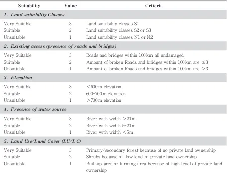
mitted were first ranked for suitability of soil and topography, access (road and bridges conditions), elevation, water source availability (river size), and land cover / land use (Table 1). Each parameter was given a value ranging from 1 (unsuitable) to 3 (very suitable) to describe the fitness for sugar cane cul-tivation (Table 1).
The total suitability score for a discrete area was calculated by summing the score for each of the five parameters, resulting in a possible score between 5 and 15. The total scores were arranged into three grades: 13-15 very suitable area; 9-12 suitable area; 5-8 not suitable area. Additionally, buffer zones were iden-tified along roads, and rivers and around settlement to identify the net area available for sugarcane planta-tion. The size of the buffer zones were as follow:
a. 500 m on both side of roads (based on survey result and interview location)
b. 30 m on both sides of rivers (Government Regu-lation no. 38, 2011)
c. 250 m around settlement (based on the result of site survey and interviews)
After determining the net area available for sugar-cane plantation, the economic viability of a sugar mill, was evaluated based on a mill capacity of >8,000 tonnes cane crushed per day (TCD) (Indraningsih et al., 2007).
4. Result
4.1 Area Suitable for Sugarcane Plantation
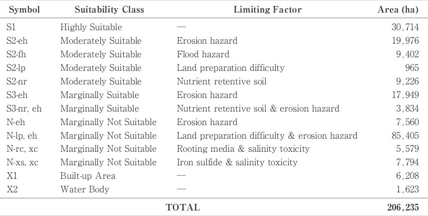
The land in large contiguous areas of suitability classes S1, S2 and S3 were considered suitable for sugarcane plantation (Fig. 2). The area of each land unit for each the limiting factors are presented in Table 2. A sugarcane mill is not viable unless the area of sugarcane producing land within an economically
J. Dev. Sus. Agr. 9 (2)
92
Unsuitable Unsuitable
1. Land suitability Classes
3. Elevation
Very Suitable
<600 m elevation 3
Suitability
Very Suitable
Table 1. Criteria used in this study for describe the fitness for sugar cane cultivation according to five parameters
Shrubs because of low level of private land ownership
2. Existing access (presence of roads and bridges)
Criteria
2 Suitable
Built-up area or farming area because of high level of private land ownership
Amount of broken Roads and bridges within 100 km are≤3 2
Suitable
Amount of broken Roads and bridges within 100 km are>3
1 1
Roads and bridges within 100 km all undamaged Value
Land suitability classes N1 or N2 1
Unsuitable
5. Land Use/Land Cover (LU/LC)
Primary/secondary forest because of no private land ownership 3
Very Suitable
2 Suitable
>700 m elevation 1
Land suitability classes S1 3
Very Suitable
Unsuitable
4. Presence of water source
River with width>20 m 3
Land suitability classes S2 or S3 2
Very Suitable
Fig. 2. Land suitability classes for sugarcane based on field survey and laboratory analysis in East Seram District, Indonesia
Area (ha)
N-eh
─ S1
Land preparation difficulty & erosion hazard Marginally Not Suitable
N-lp, eh S3-eh
Rooting media & salinity toxicity Marginally Not Suitable
Symbol
N-rc, xc
Table 2. Area of land in each land suitability class for sugarcane growing in East Seram District.
9,226 Nutrient retentive soil
Moderately Suitable S2-nr
Limiting Factor
965 9,402 19,976
Nutrient retentive soil & erosion hazard Marginally Suitable
S3-nr, eh
Erosion hazard
30,714
Marginally Not Suitable
Erosion hazard Suitability Class
S2-fh
─ Water Body
X2
206,235 Land preparation difficulty
Moderately Suitable S2-lp
TOTAL
5,579 85,405 7,560 3,834 17,949
7,794 Iron sulfide & salinity toxicity
Erosion hazard Moderately Suitable
S2-eh
Marginally Not Suitable N-xs, xc
6,208 ─
Built-up Area X1
Flood hazard Moderately Suitable
1,623 Highly Suitable
viable can support a mill productivity of>8,000 TCD
i.e., an area of at least 15,000 ha with assumed produc-tion of 1,200,000 tons of sugarcane per year. The distribution of the suitability classes in the study area is presented in Fig. 3. The land suitable for sugarcane production was found to be 34,895 ha distributed in three suitability classes as follows: 16,802 ha in the highly suitable (S1) class, 14,929 ha in the moderately suitable (S2) class, and 3,164 ha in the marginally suitable (S3) class. However some of these areas were classified as being moderately suitable or marginally suitable for sugarcane growing, but subject to non-permanent limiting factors for production; we iden-tified 11,020 ha of land in class S2-eh (moderately suitable but limited by erosion hazard), 894 ha in class S2-fh (moderately suitable but limited by flood hazard, 3,015 ha in class S2-nr (moderately suitable but limited by nutrient retentive soil), 1,685 ha in class S3-er (marginally suitable but limited by erosion hazard) and 1,478 ha class S3-nr, eh (marginally suitable but
limited by nutrient retention soil and erosion hazard). Based on the existing land use maps, 79.5% of the land considered suitable for sugarcane growing (with or without limitations) consist of logged forest or secondary forest (Fig. 3).
4.2 Land optimization for sugarcane plantation
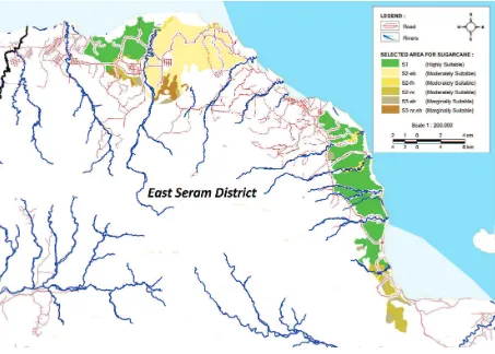
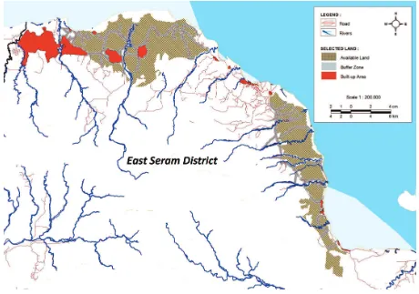
The result of the optimization analysis show that there are two separate areas within the region that are suitable for sugarcane plantation and potentially large enough to support a viable sugar refining industry (Fig. 4). The first area is 19,916 ha in the north. Of this area, 14,298 ha is core land that can be used for plan-tation and 5,618 ha is buffer zone along roads or rivers. The second area is 14,978 ha in a more elongated dis-tribution in the southeast. This area comprises 11,116 ha of core plantation and 3,862 ha of buffer. The total area of 34,894 ha potentially useable for sugarcane plantations is therefore divided into 26,006 ha of core plantation area and 9,480 ha of buffer area. Assuming
J. Dev. Sus. Agr. 9 (2)
94
sugarcane production of 80 t/ha, the total sugarcane production from the fully developed core plantation area would be 2,119,424 t/year. The predicted annual production over an assumed 150-day milling season would support mill productivity of 14,129 TCD (14,000 TCD). This value is well above the 8,000 TCD required to secure economic feasibility of a sugar mill, but is short of the 16,000 TCD needed to support two mills.
The use of land for sugarcane plantations in this area will hopefully lead to the optimization of agricultural land by converting uncultivated land into productive land. In turn, this will expand employment and busi-ness opportunities in East Seram (DEPTAN, 2012).
5. Conclusions and recommendation for optimization of land use for
sugarcane plantations
We identified the optimal potential land allocation for the sugar industry in East Seram using multi-criteria decision making method and showed. That a
gross area of 34,894 ha of land exist with a net area 26,006 ha distributed between two separates areas.
Further study is needed to provide a more detailed optimization.
Acknowledgements
We thank Dedi Rahadian, Dr. Sunarwidi and Ajeng Trimaharani of the Operational Division of Agro Wahana Bumi Co. for technical support and materials supplied for this study. This work was supported by a Preliminary Operational Division Grant of Agro Wahana Bumi Co.
References
Anonymous 2009. SRTM Data. www.cgiar-csi.org. (accessed October 1, 2009)
Anonymous 2010. Landsat TM +5 path 107/row 62. www. earthexplorer.usgs.gov (accessed February 12, 2010) Anonymous 2012. Land Suitability Analysis for Commodities.
http://bbsdlp.litbang.deptan.go.id. (accessed March 1, 2012) Baja S., Ramlan A., Amrullah A., Ramli M. 2011. Spatial based analysis of marginal land suitability for prime commodity
development in south Sulawesi. Proceedings of “Geospasial dalam Pembangunan Wilayah dan Kota”. Dipenogoro University, Semarang, 1-14.
Bandyopadhyay S., Jaiswal R.K., Hedge V.S., Jayaraman V. 2009. Assessment of land suitability potential for agriculture using remote sensing and GIS based approach. Int. J. Remote Sens. 30, 879-895.
Bojorquez-Tapia L.A., Diaz-Mondragon S., Ezcurra E. 2001. GIS-Based approach for participatory decision making and land suitability assessment. Int. J. Geogr. Inf. Sci. 15, 129-151.
Boonyanuphap J., Wattanachaiyingcharoen D., Sakurai K., 2004. GIS-based land suitability assessment for Musa (ABB group) plantation. J. Appl. Hort. 6, 3-10.
BPS 2009. East Seram District in Figures 2009. Statistics Indonesia, Jakarta.
BPS 2011. Statistical Yearbook Indonesia 2011. Statistics Indonesia, Jakarta.
DEPTAN 2012. Technical Guidelines for Optimization Concept of Developing Land for Fiscal Year 2012. Directorate General for Agriculture Infrastructure, Jakarta, 1-4. Djaenuddin D., Basuni H., Hardjowigeno S., Subagyo M.,
Sukardi, Ismangun, Marsudi D., Suharta N., Hakim L., Widagdo, Dai J., Suwandi V., Bachri S., Jorden E.R. 1994. Land Suitability for Agriculturral and Silvicultural Plants. Technical Report No. 7, Version 1.0, LREP II. Center for Soil and Agroclimate Research, Bogor.
Djaenudin D., Hidayat A., Suhardjo H. and Hikmatullah 2003. Technical Guideline for Land Evaluation for Agricultural Commodities 1stEdition. Center for Soil and Agroclimate Research, Bogor.
FAO 1985. Guidelines: Land Evaluation for Irrigated Agri-culture. FAO Soil Bulletin No.55. Food and Agriculture Organization of the United Nations, Rome.
Gafoer S., Suwitodirjo K., Suharsono 1993. Geological Map Sheet Bula and Watubela Maluku Scale 1:250,000. Indo-nesian Geological Research Centre, Bandung.
Hardjowigeno S. and Widiatmaka 2007. Land Suitability Evalu-ation for Land ClassificEvalu-ation and Planning. Gadjah Mada University Press, Yogyakarta.
Hossain M.S., Chowdhury S.R., Das N.G., Rahaman M.M. 2007. Multi-criteria evaluation approach to GIS-based land-suitability classification for tilapia farming in Ban-gladesh. Aquaculture International. 15, 425-443. Indraningsih, Suci K., Malian H.A. 2007. Sugar Develepmont
Perspective in Indonesia. Indonesian Social Economic and Policy for Agricultural Research Center, Bogor.
James G. 2004. Sugarcane. Blackwell Science Ltd., Oxford. Joerin F., Theriault M., Musy A. 2001. Using GIS and
out-ranking multicriteria analysis for land-use suitability as-sessment. Int. J. Geogr. Inf. Sci. 15, 153-174.
Marthen P.S., Edwin D.W., Andriko N.S. 2010. Land suitability and purposed land use of Selaru Island, West-Southeast Moluccas Regency. J. Trop. Soils. 15, 169-178.
Oldeman, Las I., Muladi 1980. The Agroclimate Maps of Kalimantan, Maluku, Irian Jaya and Bali, West and East Nusa Tenggara. Contr. Centr. Res. Inst. Agric. Bogor 60, 1-32.
Osly P.J., Midan A.S., Trimaharini A. 2012. Inventory Book of Forest Utilization, Agriculture and Mining in West Nusa Tenggara, East Nusa Tenggara, Maluku, North Maluku, Papua and West Papua. KORINDO, Jakarta.
PUSLITANAK 1996. Semi Detailed Soil Mapping Wahai Regional, North Seram, Central Maluku, Maluku Province for Estate Development, Irrigation and Transmigration. Technical Report No. 06/PSLA/01. 02-A/96. Indonesian Agency for Agricultural Research and Development, Bogor.
PPT 1985. Exploration Level Land Survey and Mapping on Northern Area of Seram Island Central Maluku District Maluku Province, Technical Report No. 50/1985. P3MT. Indonesian Agency for Agricultural Research and De-velopment, Bogor.
Pradana B., Sudarsono B., Sabiyanto S. 2013. Land suitability analysis for agriculture commodities in Cilacap District. J. Geodesi Undip 2, 1-12.
Wandahwa P., van Ranst E. 1996. Qualitative land suitability assessment for pyrethrum cultivation in west Kenya based upon computer-captured expert knowledge and GIS. Agr. Ecosyst. Environ. 56, 187-202.
J. Dev. Sus. Agr. 9 (2)