THE STUDY OF RAILWAYS INTERMODALITY AS
ALTERNATIVES OFCPO TRANSPORTATION
IN CENTRAL KALIMANTAN
Abstract
Severalintermodal transportation models have been analyzed to convincethe integration of spatial and transportation modeling by using the existing transportation infrastructures (such as road and river networks, ports, etc.). Themodeling analysis of CPO transportation in Central Kalimantan Province using geographical information system(GIS)showed that intermodal transportation, especially combination of road-river networks, is the best alternative obtained from the models. In order to have a more robust model and to predict the likely effect of new transport infrastructures to the cost efficiency (in term of generalized cost), hence, it is required to analyze a future scenario. To do so, a case study of spatial and transportation modeling by integrating inter-modality concept between the existing transportation networks and planned railways in Central Kalimantan is also conducted by using ArcGIS. By considering all networks (road, river, railways, and intermodal networks), the reasonable minimum generalized cost (GC) to be applied in the field is a combination of road-rail-river networks.
Keywords: CPO, generalized costs, GIS,intermodal transportation, railways
INTRODUCTION
Freight transportation has important role in regional and economic development, specifically to ensure the efficient movement and availability of materials/goods. To enhance the efficiency and quality of freight transportation, it is necessary to improve the overall cost effectiveness and function of transport operations and infrastructures. Nowadays, it is more and more realized that inter-modality may provide a key towards a better performing transport system (Kreutzbergeret al, 2006) because of environmental concerns, reasons of efficiency and benefits of co-ordination of modes to cope with growing transportation flows (OECD, 1997 in Bontekoning, 2000; 2004).
Several studiesconcerning intermodal freight transportation have been conducted to analyze the integration of spatial and transportation modeling using the existing transportation infrastructures (i.e.road and river networks, general and special ports, etc.) to modeling CPO transportation in Central Kalimantan Province. The case studies of CPO transportation modeling in Central Kalimantan Province in the period of 2010 up to 2012 showed that generally intermodal transportation, especially combination of road-river networks is the best alternative obtained from the models and it is recommended to be applied in the real world(Mahmudah et al, 2010; 2011, 2012). In order to have a more robust model and to predict the likely effect of new transport infrastructures to the cost efficiency (in term of generalized cost), hence, it is required to analyze a future scenario.
Noor Mahmudah
Lecturer
Department of Civil Engineering Faculty of Engineering UniversitasMuhammadiyah Yogyakarta Jl. Lingkar Barat, Kasihan, Bantul 55183
Tel: (0274) 6497249 E-mail: [email protected]
DanangParikesit
Professor
Dept.of Civil and Environmental Engineering Faculty of Engineering
Universitas GadjahMada Jl. Grafika No. 2Yogyakarta 55281 Tel: (0274) 901075; Fax: (0274) 901075
The 18th FSTPT International Symposium, Unila,Bandar Lampung, August28, 2015
To do so, a case study of spatial and transportation modeling by integrating inter-modality concept between the existing transportation infrastructures and planned (future) railways in Central Kalimantan is carried out (Mahmudah, 2014).
METHODS
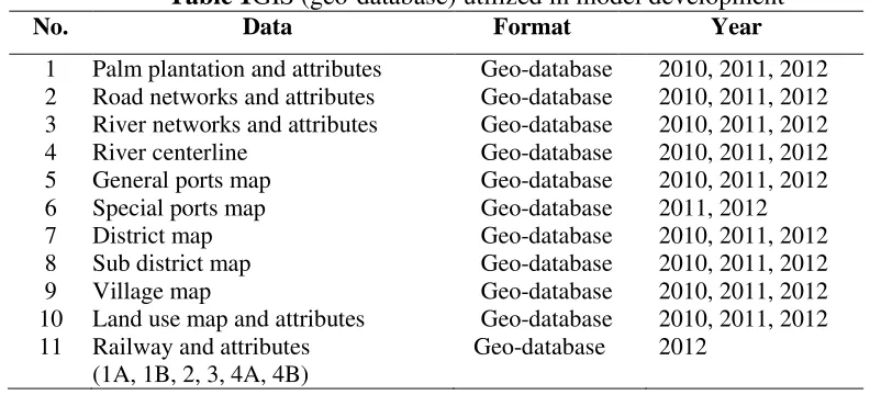
In this study, the model development is considered a planned railways network in Central Kalimantan. The data used in model development in the period of 2010 to 2013are as presented inTable 1.Transportation infrastructures and CPO factories (formatted in geo-database) considered in spatial and transportation modelling are as shown in Table 2.
Table 1GIS (geo-database) utilized in model development
No. Data Format Year
1 Palm plantation and attributes Geo-database 2010, 2011, 2012
2 Road networks and attributes Geo-database 2010, 2011, 2012
3 River networks and attributes Geo-database 2010, 2011, 2012
4 River centerline Geo-database 2010, 2011, 2012
5 General ports map Geo-database 2010, 2011, 2012
6 Special ports map Geo-database 2011, 2012
7 District map Geo-database 2010, 2011, 2012
8 Sub district map Geo-database 2010, 2011, 2012
9 Village map Geo-database 2010, 2011, 2012
10 Land use map and attributes Geo-database 2010, 2011, 2012
11 Railway and attributes
(1A, 1B, 2, 3, 4A, 4B)
Geo-database 2012
Table 2The infrastructures and CPO factories considered in the model
Transportation networks Number of
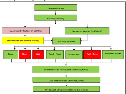
general port intermodal transportation using ArcGIS 10.1 as follows:
can be located using ArcGIS software. These CPO factories are supposed to be the origin points of freight transportation simulated in the models.
Figure 1The conceptual framework formodel development using ArcGIS (Source: Mahmudah, 2014)
2) Access of CPO factories. By using the closest facility of ArcGIS software, access of CPO factories to transportation networks (in term of distance) can be determined. Furthermore, these accesses are then classified as good (distance of 0 to 10 km), moderate (10 to 20 km), and bad (20-30 km);
3) The shortest route of CPO factories to the final destination (general ports). Utilizing network analysis of ArcGIS, the shortest path of each CPO factory (origin) to the port (destination)-in term of travel distance and time, using different transportation networks can be determined. Spatial mapping of shortest route for CPO factories to ports can also be plotted using ArcGIS. Due to river networks as well as railways and intermodal rail-river networks (as indicated in the red boxes of Figure 1), cannot be applied in the real world due to these transport networks need the road networks to deliver CPO to river or railways, so they do not take into consideration for the final desicion of mode choice based on generalized cost (GC);
The 18th FSTPT International Symposium, Unila,Bandar Lampung, August28, 2015
5) Generalized cost (GC) is considered as the indicator of transportation performance. To determine GC, travel distance andtime, which are obtained from shortest route analysis using ArcGIS, are then further calculated by employing equation 1 for various transportation networks. The GC of the same O-D pair with different transportation networks is compared. The lowest GC is chosen as the optimum one.
= ( , + , ∗ ) ∗ , (1)
Where
: generalized cost (Rp)
, : fare from i to j on link r for mode type m (Rp/T) incl. transfer cost
: value of time (Rp/T/hour)
, : total travel time spent from i to j on link r for mode type m (hour)
, : weight of commodity transported from i to j on link r for mode type m (T)
Value of time (VoT) is weighted by considering the type of commodity. In this study, the FEMEX(Fidelity Advisor Emerging Europe Middle East Fund) standard, is used to determine the value of time. According to FEMEX (2003), the value of time for bulk
commodity is 0,63 euro/ton/hour or equal to Rp 7.700/ton/hour (Mahmudah et al, 2012).
RESULTS AND DISCUSSIONS
1) Model development. In model development, there are some analysis conducted among other: closest facilities to analyze the access, shortest route analysis to calculate the shortest distance and time of each factory to certain port, O-D cost matrices to determine the best O-D pair (CPO factory-port) using specific transport networks, and to calculate generalized costs based on travel distance and time obtained from shortest route analysis. More specifically, there are two types of generalized cost analyzed. Firstly, generalized cost by considering all CPO factories by employing 2 general ports (Bagendang and Bumiharjo) with 3 transportation networks (road, river, and inter-modal road-river networks). This model fits with the real condition in Central Kalimantan Province. Secondly, generalized cost by considering CPO factories located along railways link 1A and 1B. The second model attempts to predict future transportation system by including the planned railways as a transportation network beside road and river. The new general ports located in Bangkuang and LupakDalamare also considered in the second developed model instead of Bagendang and Bumiharjo ports. The analysis results of spatial and transportation modeling using ArcGIS 10.1 are as illustrated in Appendix 1 and 2 respectively.
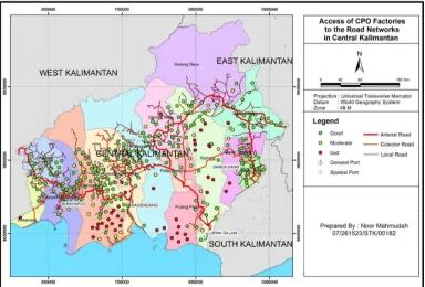
river network still has a is between 10 and 30 km
Figure 2The
Figure 3Accessib
3) Generalized cost (GC) using ArcGIS can prod
s a chance to compete to other networks when km (see Figure 2 and 3).
he accessibilityof all CPO factories to the netwo
sibility of CPO factories along railways link 1A
C) by considering all CPO factories. The shor oduce the shortest distance and time needed fo ) to the selected port (destination). Employin C) of each O-D matrices, which is for transp road, river, and intermodal road-river network of different networks are compared, the cheap l river networks, followed by intermodal road-orks as the most expensive one. However, th st travel time due to long haul distance.
C) by considering CPO factories along rail lin CPO from factory to port using road, river, ra al road-rail, intermodal rail-river, and intermo ed (see Appendix 3). If all GC of various netwo s againobtained by using uni-modal river n
dal road-rail-river network. However, uni-moda intermodal rail-river networks cannot be applie rt networks need the road networks to delive intermodal road-rail-river is the best option
5
rcentage of CPO factories served by the networks
5 - 10
ntage of CPO factories along rail link 1A and 1B served by the networks
en the distance range
tworks
1A and 1B
The 18th FSTPT Interna intermodal transfer (i.e. CP cost, including transfer pena planned (future) railways i considered the planned rail road, river, and railways (li and railways for link 1A and
The data obtained from sp ArcGIS 10.1 are: a) number c) access of CPO factories (general ports); e) Origin Generalized cost (GC) that i
By considering all netwo reasonable minimum gener
generalized costs using different transportatio ow. Overall, intermodal network of road-rail-r
est generalized cost.Transportation cost consid included the costs of labour and the operation a as well as the costs of roadways, storage facili ansfer (handling) of goods.To apply the interm allenge to be considered are the provision of p CPO storage in port and rail station) and the enalty, that should be calculated in more detail.
arison of generalized cost for all transportation
robust model and to predict the likely effec ransportation choice (in term of generalized cos
To do so, a case study of modeling spatial and y concept between the existing networks (ro s in Central Kalimantan is carried-out. The d railways and includesan analysis of access of
link 1A, 1B, 2, 3, 4A, and 4B) and shortest r and 1B using generalized cost (GC) as an effici
spatial and transportation modeling using ne ber of and location of CPO factories; b) locatio ries; d) shortest route of CPO factories to th in-Destination matrices (so called O-D cost at is considered as the indicator of transportatio
works (road, river, railways, and intermod eralized cost (GC) to be applied in the field is To apply the intermodal networks like road red are the provision of proper and adequate i
rt and rail station) and the transfer (handlin uld be calculated in more detail.
-500,000 1,000,000 1,500,000 2,000,000
RoadRoad- RiverRoad - Rail Road-Rail-River
Max 1,124,153 1,028,076 1,236,682 1,082,790
Average736,599 497,974 653,198 433,555
Comparison of GC for all transportation ne
g, August28, 2015 cost), it is required to and transportation by te intermodal transfer ling) cost, including
ACKNOWLEDGEMENTS
My sincere appreciation is addressed to Prof. Dr. Ir. SitiMalkhamah, M.Sc., and Prof. Ir. SigitPriyanto, M.Sc., Ph.D. from Universitas Gadjah Mada and Dr. Ir. M.H.P. (Mark) Zuidgeest from University of Twente, for their guidance, support, encouragement, and constructive critism during conducting the research.
REFERENCES
Bontekoning, Y, M, Macharis, C, and Trip, J, J, 2004, Is a new applied transportation research field emerging?—A review of intermodal rail-truck freight transport literature, Transportation Research Part A 38 (2004), pages 1–34
Bontekoning, Y, M, 2000, A jump forward in intermodal freight transport: are hub-terminals an alternative for shunting? TRAIL Research School, Delft
Kreutzberger, E, Macharis, C, and Woxenius, J, 2006a, Intermodal versus unimodal road freight transport, in Towards Better Performing Transport Networks, Routledge, Oxon, pages 17 – 42
Mahmudah, N., 2014,The Development of Methodology for Regional Transportation Planning: Freight Transportation Model in Central Kalimantan, Indonesia,Dissertation, Graduate Program of Civil Engineering Faculty of Engineering Universitas Gadjah Mada, Yogyakarta (unpublished)
Mahmudah, N., Parikesit, D., Malkhamah S., Priyanto, S, 2012,Study of Regional Transportation for CPO in Central Kalimantan, Proceedings of the 15th International Symposium FSTPT, 23 - 24 November 2012,Bekasi
Mahmudah, N., Parikesit, D., Malkhamah S., Priyanto, S, 2011,Pengembangan Metodologi Transportasi Barang Regional, Jurnal Transportasi Vol. 11 No. 3, December 2011,
pages 173-182
Mahmudah, N., Parikesit, D., Malkhamah S., Priyanto, S, 2011,Pengembangan Metodologi Transportasi Barang Regional, Proceedings of the 14th International Symphosium FSTPT, 11 – 12 November 2011,Pekanbaru
Mahmudah, N., Parikesit, D., Malkhamah S., Priyanto, S., Zuidgeest, M, 2011, Modeling Freight Transportation for Crude Palm Oil in Central Kalimantan, Proceeding of the 3rd International Conferences of European Asian Civil Engineering Forum (EACEF) 2011, 20-22 September 2011, Universitas Atma Jaya, Yogyakarta, pages 49-54
Mahmudah, N, 2011,Pemodelan Transportasi Barang Regional untuk Crude Palm Oil (CPO) di Kalimantan Tengah,Indonesia, Final Report of Dissertation Grant FY 2011,Institute for Research and Community Service (LPPM) Universitas Gadjah Mada, Yogyakarta (unpublished)
Mahmudah, N., Parikesit, D., Malkhamah S., Priyanto, S, 2010, Regional Freight Transportation Model for Crude Palm Oil (CPO) in Central Kalimantan, Jurnal Transportasi Vol 10 No. 3, December 2010, pages 213-224
Mahmudah, N., Parikesit, D., Malkhamah S., Priyanto, S., Zuidgeest, M, 2010, Regional Freight Transportation Planning: An Overview of Developing Methodology,
The 18th FSTPT International Symposium, Unila,Bandar Lampung, August28, 2015
Figure 3Intermodal road-river networks in Central Kalimantan
The 18th FSTPT International Symposium, Unila,Bandar Lampung, August28, 2015