The Responses of the Philippines to People's Republic of
China (PRC) Actions on South China Sea (2012)
An Undergraduate Thesis
Submitted to the Faculty of Social and Political Sciences In Partial Fulfilment of the Requirements for Bachelor of Arts (B.A.) in International Relations
Written By:
Laksono Nayaparitosa
107083100072
---.
Ulll
Universitas Islam NegeriSYARIF HIDAYATULLAM JAKARTA
DEPARTMENT OF INTERNATIONAL RELATIONS
FACULTY OF SOCIAL AND POLITICAL SCIENCES
STATE ISLAMIC UNIVERSITY SYARIF HIDAYATULLAH
JAKARTA
THE RESPONSES OF THE PIDLIPPINES TO PEOPLE'S
REPUBLIC OF CHINA (PRC) ACTIONS ON SOUTH CIDNA
SEA(2012)
Written by:
Name
Student Number
Laksono
Nayaparitosa-: 107083100072
Approved by Thesis Adviser,
Budi S. Satari, MA
DEPARTMENT OF INTERNATIONAL RELATIONS
FACULTY OF SOCIAL AND POLITICAL SCIENCES
STATE ISLAMIC UNIVERSITY SYARIF IDDAYATULLAH
JAKARTA
THESIS ADVISER RECOMMENDATION LETTER
Thesis adviser hereby declares that the student:
Name : Laksono Nayaparitosa
Student ID : 107083100072
Major ·: International Relations
Has finished the undergraduate thesis entitled:
THE RESPONSES OF THE PHILIPPINES TO PEOPLE'S
REPUBLIC OF CHINA (PRC) ACTIONS ON SOUTH CHINA
SEA(2012)
And fulfilled requirements to be examined.
Acknowledged by, Head of Department
Debbie Affiyanti, MA.
Jakarta, 10 July 2014
Approved by, Thesis Adviser
PANEL OF EXAMINER APPROVAL SHEET
THESIS
THE RESPONSES OF THE PHILIPPINES TO PEOPLE'S REPUBLIC OF CHINA (PRC) ACTIONS ON SOUTH CHINA SEA (2012)
Written by Laksono Nayaparitosa
107083100072
Has been defended in thesis oral defense in the Faculty of Social and Political Sciences of State Islamic University SyarifHidayatullah Jakarta on 15 July 2014. This thesis was thereof and approved as partial fulfillment of the requirements for Bachelor of Arts (B.A) in International Relations.
Head of Oral Defense,
AgusN2M.Si
NIP.197808042009121002
NIP.197808042009121002
Examiner I, Examiner II,
Mutiara Pertiwi, MA.
NIP.198011292009122002
Head of Department
Faculty of Social and Political Sciences
DECLARATION OF ORIGINALITY
This thesis entitled:
THE RESPONSES OF THE PIDLIPPINES TO PEOPLE'S
REPUBLIC OF CHINA (PRC) ACTIONS ON SOUTH CHINA
SEA(2012)
1. Is my original work proposed to fulfill one of the requirements to obtain an undergraduate degree in State Islamic University (UIN) Syarif Hidayatullah Jakarta.
2. All Sources in this thesis, I attached according to the rules applied in State Islamic University (UIN) SyarifHidayatullah Jakarta.
3. If this thesis in afterwards found not as my original work or recognize as plagiarize from other's work, I agree to take all the responsibilities and penalties applied by State Islamic University (UIN) Syarif Hidayatullah Jakarta.
Jakarta, 10 July 2014
PREFACE
Alhamdulillahirabbil 'alamin, all praises to Allah the Creator of mankind with His superiorities and shortage. Shalawat and Salaam to His messenger prophet Muhammad PBUH as well as his family, companions, and his adherent. With His mercy the author could complete this thesis entitled "The Responses of the Philippines to People's Republic of China {PRC) Actions on South China Sea {2012)'' with all experiences the author have been through.
In this occasion, the author would express his gratitude to his beloved parents who have never stopped to encourage; teach, and fight for the children, my brother and sister. I would also say thanks and my appreciation to all lectures who taught and shared their knowledge and experiences to me in this university especially to Mr. Budi S. Satari, MA. as my thesis adviser and encourage me to finish this thesis, Mrs. Debbie Affianty, MA. as the Head of Department of International relations who introduce me this topic and all staffs in the Faculty of Social and Political Sciences of State Islamic University Syarif Hidayatullah Jakarta.
The author also would say thanks to all of my fellow classmates in International relations (International Class), all of my juniors, my best friends, and many people that I cannot mention one by one in here. Finally, the author dedicate this thesis as reward for my struggle, effort, patience in facing the challenges and also hopes that this thesis can be useful for the readers. Amiin.
Jakarta, July 2014
Laksono Nayaparitosa
ABSTRACT
Keywords: South China Sea, Philippines, Peoples Republic of China, Scarborough Shoal, maritime disputes, foreign policy.
South China Sea is one of the waters with potential source of hydrocarbons, fishery, as well as important world trade route and holds significant strategic and political importance in at once. Several of the sea bordering countries declares ownership of the islands in South China Sea to claim the surrounding sea and its resources especially the Philippines and People's Republic of China (PRC).
This thesis elaborates the history of South China Sea dispute from 2002-2011 as well as the reasOJ?. both Philippines and PRC claims area in the South China Sea. Moreover, this thesis also elaborates the response of the Philippines over the dispute in the South China Sea towards the actions of People's Republic_ of China (PRC) particularly on the 2012 incident between both of countries happens in Scarborough shoal. When the incident happens, the Philippines realize that the PRC's actions in the South China Sea could harm the Philippines national security. As a response, the Philippines government then decided it is necessary to create appropriate policies and steps to protect both national security and national interests at the same time. As tools to analyze this study, the author used Realism, National Security, and Foreign Policy.
CONTENTS
PREFACE ... vi
ABSTRACT ... vii
CONTENTS ... viii
LIST OF IMAGES ... x
LIST OF ABBREVIATIONS ... xii
LIST OF ATTACHMENTS ... xiii
CHAPTER I: INTRODUCTION A. Background ... 1
B. Research Questions ... 5
C. Research Objectives ... 5
D. Literature Review ... 6
E. Theoretical Framework ... セ@... 8
F. Research Method ... 13
G. Outline ... 14
CHAPTER II: THE OVERLAPPING CLAIMS BETWEEN PEOPLE'S REPUBLIC OF CHINA AND PHILIPPINES ON SOUTH CHINA SEA A. History of South China Sea dispute from 2002 - 2011 ... 16
B. Reason of People's Republic of China claimed the South China Sea as their territory ... 22
CHAPTER III: THE SCARBOROUGH SHOAL INCIDENT AND ITS
IMPACT TO THE PHILIPPINES NATIONAL
SECURITY
A. Scarborough shoal incident (2012) ... 29 B. The impacts of the Scarborough Shoal incident to Philippines national
security ... 33 1. Physical dimension ... 34 2. Psychological dimension ... 38
CHAPTER IV: THE RESPONSES FROM THE PHILIPPINES TOWARD PEOPLE'S REPUBLIC OF CHINA ACTIONS ON SOUTH CHINA SEA
A. Philippines foreign policy toward the Scarborough Shoal incident ... 42 B. Philippines strategy toward PRC's actions on South China Sea ... 48
I. Philippines joint military cooperation and military equipment acquisition ... 48 2. The Philippines No.29 President's Administrative Order ... 51 C. Philippines - People's Republic of China relationships at present ... 53
CHAPTER V: CONCLUSION
Conclusion ... ; ... 56
List of Images
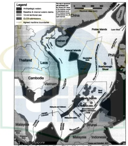
Figure 1.I The South China Sea Map Legend
- Archipelagic wa1al"s
- Baseline & internal waters claims 12-nmtenitolial sea
1111111 Cl.CS submissions
Source: Centre for International Law ofNational University of Singapore (2013)
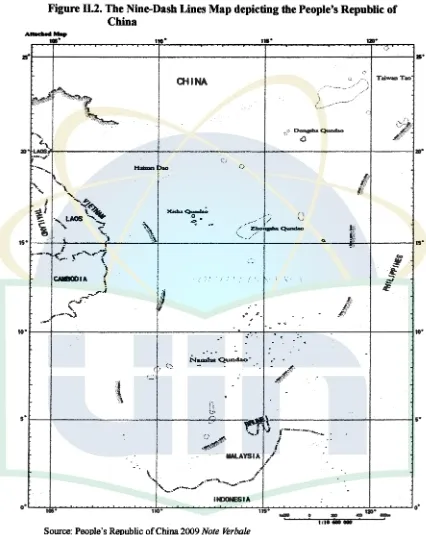
Figure ll.2. The Nine-Dash Lines Map depicting the People's Republic of China
•••
us•OllNA Taiwa>Tao
ltlJONESI A
Source: People's Republic of China 2009 Note Verbale
List of Abbreviations
AFP ASEAN CHED CLCScoc
DND DepEd DOC EEZ GDP ITLOS KIG NAMRIA NM MOU PRC RIMPAC UN UN CLOS USA: Armed Forces of the Philippines
: Association of South East Asian Nations : Commission on Higher Education
: Commission on the Limits of the Continental Shelf : Code of Conduct
: Department of Defense : Department of Education
: Declaration on the Conduct of Parties : Exclusive Economic Zone
: Gross Domestic Products
: International Tribunal for the Law of the Sea : Kalayaan Island Groups
: The National Mapping and Resource Information Authority : Nautical Miles
: Memorandum of Understanding : People's Republic of China
: Rim of Pacific Multilateral Naval Exercise : United Nations
A. Background
Chapter
I
Introduction
South China Sea is a part of Pacific Ocean which covers most areas of
Singapore straits, Malacca straits and Taiwan straits. It is located at the south side
of the People's Republic of China (PRC) and Taiwan; in the west of the
Philippines, the Sea of Sabah (Malaysia); in the north of,Sarawak (Malaysia) and
Brunei; in the northeast of the Malay Peninsula (Malaysia), Singapore; and east of
Vietnam (National Geospatial Inteligence Agency, 2004, p. 3). This area has 3,5
million kilometers wide, and based on size, the South China Sea is the widest
waters area beside the 5 (five) oceans. Geographically, the South China Sea
stretch out from the southwest to the northeast, the south boundaries between
South Sumatra and Kalimantan (Karimata Strait), and its northern boundary is the
Taiwan Strait from Taiwan to. the northern end of the coastal Fujian in China
Mainland (Global Security Org, 2011). Furthermore, the South China Sea grouped
into 5 (five) archipelagos namely The Spratly Islands, The Paracel Islands,
The Pratas Islands, The Macclesfield Bank and The Scarborough Shoal (Trade
and Environtment Database, 1997).
The South China Sea has massive potential natural resources. It contains
an enormous oil reserves, natural gas and huge fishery potentials. It is estimated
approximately 11 billion of oil and 190 billion cubic feet of natural gas in proved
2013). Moreover, South China Sea also plays an important role for gas
distribution lines, trade lines, and international shipping lines. Thus, with massive
natural resources in the area, and number of countries are involved in the dispute,
then the potential for conflict that will arise even bigger and more complex.
Basically, dispute in the South China Sea aroused since over 40 years ago
with 6 (six) actors and each claimed the sovereignty of the region: China, Taiwan,
Vietnam, Malaysia, Philippines and Brunei (Cheng, 2013). Each of countries also
has different arguments both history and law. Indeed, according to Peter Dutton
(2011, p. 42) there are 3 (three) problems they concern the most which are the
disputes over territorial sovereignty in the overlapping claims in the South China
Sea's area; disputes over rightful claims jurisdiction over waters and seabed; and
disputes over the right to use the seas for military purposes. In 2002, China and
the members of the Association of Southeast Asian Nations (ASEAN) signed the
Declaration on the Conduct1 of Parties (DOC) in the South China Sea. It aimed
"to resolve their territorial and jurisdictional disputes by peaceful means, without
any resorting to the threat or use of force, through friendly consultations and
negotiations by sovereign states directly concerned" (Dutton, 2011, p. 43).
The situation in the region heats up when PRC sends note verbale2-to the
United Nations (UN) Secretary General on Friday, 7 May 2009 (United Nations
1 Declaration on the Conduct is a proposal signed by whole ASEAN members and China which
aims to resolve their territorial and jurisdictional disputes by peaceful means, without resorting to the threat or use of force. The document available at http://www.asean.org/asean/external-relations/china/item/declaration-on-the-conduct-of-parties-in-the-south-china-sea
2 Note Verbaleis a form of written correspondence via which different Diplomatic-Consular
General Secretary, 2011). The letter contains the 9 (nine) Dash Lines Policy
containing the unilateral claims over the entire region of South China Sea. The
area covers the entire Spratly Islands, which are still disputed by six bordering
countries3; and the Paracel Islands, which are still disputed by China, Taiwan and
Vietnam. These claims only based on one-sided historical perspectives from
Chinese government, where the region has become a trade route and a place for
living of Chinese explorers on the past (Jia, 2013, p. 108). Indeed, all of the
countries involved in the conflict in this region raise protest to the UN General
Secretary, except Taiwan Hb・」ォュ。ョセ@ 2013, p. 146). Meanwhile, the Indonesian
government also protested these claims even though Indonesia itself is not directly
involved in the dispute of the region (Jia, 2013, p. 108). After that, the situation
calmed down even though there is no concrete settlement of this problem.
The situation heats up when the Chinese Navy troops detained Philippines
Navy Surveillance team who captured Chinese illegal fisherman in the
Scarborough Shoal 4 • The dispute arouses on Sunday, 8 April 2012 when a
Philippines Navy Surveillance aircraft monitored eight Chinese fishing vessels
anchored inside the Scarborough Shoal (Dawnay, 2012). On Tuesday, 10 April 2012 this situation provoked the Philippines to deploy its only warship namely the
BRP Gregorio del Pilaar in accordance with the established of Rules of
3 Approximately 44 of the 51 small islands and reefs are claimed or occupied by China, the
Philippines, Vietnam, Taiwan, Malaysia and Brunei. See Trade and Environment Database
available at htq>://www l .american.edu/projects/mandala/TED/ice/s.pratly.htm (2007)
4 Scarborough Shoal is a ring-shaped coral reef, which has several rocks encircling a lagoon.
Engagement5• In this inspection, they have found that a large amount of illegally
collected corals, giant clamps, and live sharks in the compartment of these fishing
vessels (Philippine Department of Foreign Affairs, 2012). On the same day, two
Chinese law enforcement vessels, identified by Philippines official as a
Zhounggou Haijian 75 and Zhounggou Haijian 84, took positions at the mouth of
the lagoon within the shoal. They were blocking the Philippines Navy vessel and
its detained fishing vessels access to exit from the lagoon (Philippine Department
of Foreign Affairs, 2012). Chinese law enforcement vessels prevented the
Philippines Navy vessel from detaining Chinese fishermen allegedly caught
poaching, which results in worsening the tensions. One of the Chinese ships
radioed the Philippines ship and said that the area was Chinese territory and that
the Philippines Navy should withdraw. The Philippines captain responded that the
area was his country's territory. On 12 April, Philippines warship being withdrawn
from Scarborough Shoal with the reason to replenish fuel and food supply (Global
Nation Inquirer, 2012).
This incident has caused enormous reactions from both Philippines public
and the government. Several days after, public of the Philippines immediately
held a massive protest against China at Chinese embassy in Manila, capital of the
Philippines. Moreover, they are asked to the government of Beniqno Aquino III6
to send naval forces and requested to the government of United States of America
5Rules of Engagement (ROE) are rules or directives to military forces (including individuals) that define the circumstances, conditions, degree, and manner in which force, or actions which might be construed as provocative, may be applied.
6Benigno Simeon Cojuangco Aquino I l l also known as Noynoy Aquino is a Filipino politician
(USA) to reassert their presence in Asia in order to protect the territory at South
China Sea (Global Nation Inquirer, 2013). They also requested that all workers
from the Philippines that work in China, to return back to. home country despite
these workers having huge contributed to the foreign exchange for the Philippines
itself (The Jakarta Globe, 2012). On the other hand, the government of the
Philippines strongly reacted in the case as well. They deplored the Chinese
military actions and summoned the ambassador of China to explain about the
incident (Rosario, 2012).
Based on above explanations, we can see various reactions from the both
public and government of the Philippines to the PR C's actions on the South China
Sea. Taking all the issues into account, this research is designed to describe about
the impact on the Philippines national security post Scarborough Shoal incident.
Therefore, discussion specifically on the Philippines response, reason and efforts
will further be investigated in this study.
B. Research Questions
In order to better understand the issue about the Philippines response of
the South China Sea dispute, this research raises the question:
• How Philippines respond to the actions of People Republic of
China on South China Sea (2012)?
C. Research Objectives
South China Sea dispute as well as the reason from both People's Republic of
China and Philippines are claiming the sea and its vicinity. Second, this research
will describe and analyze the Scarborough incident as well as its impacts toward
the government of the Philippines, especially in term of national security both
physical and psychological. Third, this research will also explain and analyze
what are the responses from the government of the Philippines in term of foreign
policy making in order to defend its territory toward the actions of the People's
Republic of China post-Scarborough Shoal incident. In this chapter, this research
also describing the steps as well as the strategy that is been taken by the Republic
of the Philippines in order to solve the dispute in this region and furthermore
analyzing the relationships between two countries at the present time.
D. Literature Review
There are_ several papers and researches that have been examined on the
issue of the South China Sea conflict. However, most of those papers are focusing
on the history of the conflict; or the People's Republic of China's intention into
the region; or what are the actions or forum that been created to solve this conflict.
There is none deeply discussed in the steps and strategies that taken by the
Philippines toward the issue in South China Sea and how is the current situation.
The writer found at least 3 (three) nearest topics of the thesis that first
wrote by Santi C.D. Simamora (2001) from University of Indonesia titled
"Kebijakan Luar Negeri Cina Terhadap Konflik Spratly: Studi Kasus Ketegangan
conducted through literature study. This thesis focus on the policy that created by
the government of China toward the conflict on the South China Sea especially
after the Mischief Reef dispute. Furthermore, it also describes about the tensions
between both China and Philippines since 1995 whereas China was started to
occupy the Mischief Reef, an area that fully claimed by the Philippines. The
dispute ignited when China established a permanent building by reason as a
shelter for fishermen who are doing work in the area. Furthermore, dispute on
Mischief Reef continues to re-occur in 1999 (Simamora, 2001).
The other nearest topics is the thesis written by Kristofer L. Yost (2013)
from Naval Postgraduate School in California titled "Tension in the South China
Sea: why the Philippines is challenging China's improved military might". This
thesis conducted through literature study as well as analytic descriptive approach
and focuses on the Philippines military development effort through new policy for
modernizing its naval force as well as strengthens its military relationship with the
USA. Furthermore, this thesis also explains the reasons on the policy itself during
President Aquino administrative compared to the policies made by previous
governments during 1995-2010 (Yost, 2013).
The last nearest topics is the research written by Lowell Bautista (2013)
from East Asia and International Law journal titled "The Philippine claim to Bajo
de Masinloc in the Context of the South China Sea Dispute,;. This thesis also
conducted through analytic descriptive and aims to examine the Philippine claims
over Bajo de Masinloc particularly on the 2012 standoff between the Philippines
Law of the Sea (ITLOS) over its territory in South China Sea against China
{Bautista, 2013).
Based on the post-graduate thesis written by both Santi C.D Simamora's
and Kristofer L. Yost as well as the research written by Lowell Bautista, the writer
gained much information about the history, and also the perspective from both
China and the Philippines that could be useful in this research. However, if
compared with those literatures, this research is completely different with those
literatures. This research the writer is focusing not only on the Philippines
perspective of the conflict in South China Sea or particular actions taken by the
Philippines, but also the whole steps taken by the Philippines in respond to the
PRC actions in South China Sea. Indeed, the writer will also investigate more on
the Scarborough Shoal incident which occurred in 2012 as well as the Philippines
strategies in order to prevent similar actions doing by PRC in the future.
E. Theoretical Framework
In social studies, theory is an important component in providing social
background, justification, and supporting data. The theory is also used for the
provision of a framework for understanding social phenomena and interprets
research results. Therefore, theory is both necessary and unavoidable when it
comes to understanding or explaining international politics. This research the
writer will use Realism theory as a major theory, and then explains the National
Security and Foreign Policy as a concept.
about international politics. Most realists believe that the central problem in the
international arena is war and the use of force and the main actor is States
(Jackson & Sorensen, 1999, p. 88). The realist starts from the assumption of the
anarchic system of states. Moreover, the beginning and the end of international
politics is the result from individual state in interaction with other states (Nye,
2009, p. 4). In this point, realists assumed that state is always worried about its
survival as an independent actor (Goldstein & Pevehouse, 2007, p. 55).
1. National Security
For the Philippines, the policy implementation post the actions of China on
South China Sea are only for the sake of national security itself. Despite the
concept of national security it remains an ambiguous concept because the variety
of meanings and argument for each individual. In etymology, the word security
comes from Latina language (se cura) means free from danger and free from fear
(Hermawan, 2007, p. 26). In general, the concept of national security is defined as the need to preserve and maintain the existence of the state through economic
power, political, as well as military and development in diplomatic affairs. This
concept emphasizes the ability of government to protect and defend the territorial
integrity from both external and internal threats (Darmono, et al., 2010, p. 9).
Furthermore, according to Samuel C Sarkesian et at (2013, p. 4) the concept of
national security is the study of the problems faced by the various nations which
are translated in various policies and programs at the levels of government to
From above explanation, national security can be defined as the ability of
national institutions in order to prevent adversaries effectively from using force to
harm the citizens or their national interest and the confidence of citizens in its
capability (Sarkesian, et al., 2013). This definition then appears the two
dimensions in the concepts of national security which are the strategic dimension
and economic non-strategic dimension.
The strategic dimension is an objective measure based on the strength and
military capacity of the nation to challenge adversaries successfully including
going to war if necessary. This dimension focuses on defending the national
integrity and independency and mostly uses military perspective. Meanwhile the
economic non-strategic dimension is more subjective, showing the people
opinions and attitudes on the nation's ability to defend and protect the economic
resources and other non-military aspect relatively from external threats (Sukma,
2002). In this context, the national security can be seen as part of domestic and
foreign policy of particular countries, because the national security policy is
always influenced by domestic and foreign factors. Indeed, the national security
policy is the result from the integration of domestic politic elements and foreign
policy that affect the security of a country.
Moreover, Sarkesian (2013, p. 4) defines the national security as part of
government policy in which primarily concerned with formulating, and
implementing national strategy involving the threat or use of force to create a
favorable environment and protect the national interest of the nation itself
the South China Sea is a policy based on national interest and there is a direct
threat to the sovereignty of the state. Therefore, this theory will use to identify and
describe the impacts of the PRC's actions toward national security of the
Philippines.
2. Foreign Policy
Studies in international politics are often dominated by the study of
foreign policy. This study focuses on the description of the interests, actions and
elements of state power (Holsti, 1977, p. 17). Foreign (politics) policy is a foreign
concrete action used to achieve a country's national interest. The purpose of
foreign policy is actually influenced by the goals of the past and aspirations for
the future. Detailed foreign policy objectives are designed, selected and specified
by the decision maker and controlled to change the policy or maintain a certain
state policy in an international environment (Perwita & Y ani, 2006, p. 49).
Foreign policy is a strategy or plan of action created by the decision
makers of states in dealing with other countries or other international political unit
and it is fully controlled in order to achieve specific national goals in terms of
national interest. Furthermore, Holsti (1977, p. 18) to explain the foreign policy
sphere includes all the actions and activities of the state of the external
environment in an attempt to profit from the environment, as well as their
attention to the internal state will share in supporting the formulation of such
action. Indeed, the actions focus on the defining purpose, choosing among courses
of action, and utilizing national capabilities to achieve a various objectives in the
According to Holsti (1977, p. 145), foreign policy has three types of
objectives that reflect to the wider interests based on time, namely:
1. "Core" objectives (as a basic principle of foreign policy), guidelines that
suggest a basic foreign policy action by decision-makers and pursue the
ensuring of the sovereignty and the independence of state territory. Indeed,
this orientation preserves a particular political, social, and economic
system on its territory. These perceptions and values are derived from
historical experience and current positioning country conditions in
international politics.
2. "Middle Range" objectives (as a set of increasing a state prestige), a real
step in the form of action and commitments over concrete goals and no
particular time element but it's expected to pursue with more economically
advanced countries within their own lifetimes. The tool for maintaining
these objectives through diplomatic ceremonial and displays of military
capabilities and measured by levels of industrial development or
technological skills, but neglect to micro-economic poverty that may
influenced by the foreign policy orientation.
3. "Long Range" objectives (as a form of dreams or visions), a step based on
the general orientation, with the commitments and targets more universal,
which related to middle range· goals. This orientation needs a creation of
the states on the particular demands against particular states in order to
pursue its objectives and to reconstruct an entire international system to
Furthermore, the Foreign Policy theory will use to describe and analyze
the response that been taken by the Philippines policy maker in dealing with the
PRC's actions on the South China Sea. This research also will only focus on the
post-Scarborough Shoal incident in order to limit the extent of the problems that
exist in South China Sea.
F. Research Methods
This research will use qualitative methods with analytic descriptive
approach and based on literature study technique. According to Sangadji and
Sopiah (2010, pp. 24-37), qualitative method is a research methodology in which
the outcome of the research is produced through describing systematically the
facts, objects or subjects being investigated appropriately. The qualitative methods
will use only secondary data. Secondary data will obtain through books, online
journals, online news, official documents, as well as papers that are directly
related to the research. The writers will seek those of the data's from several
resources such Centre for Strategic and International Studies (CSIS) library,
Lembaga Ilmu Pengetahuan Indonesia (LIPI) library and online website. This
approach is expected to provide answers about the government of the Philippines
response toward PRC's actions on the South China Sea based on
G. Outline
In order to fulfill its requirement, this research will divide into 5 (five) chapters with some of subchapters in it and arranged as follows:
Chapter I
Chapter II
Chapter III
Background
A. Background
B. Research Question
C. Research Objectives
D. Literature Review
E. Theoretical Framework
F. Research Methodology
G. Outline
The overlapping claims between People's Republic of China
and the Philippines on South China Sea
A. History of South China Sea dispute from 2002 -2011
B. Reason of People's Republic of China claims the South
China Sea as their territory
C. Philippines justification on the several areas in South
China Sea
The Scarborough Shoal incident and its impact to the
Philippines national security
Chapter IV
B. The impacts of the Scarborough Shoal incident to
Philippines national security
1. Physical dimension 2. Psychological dimension
The responses from the Philippines toward People's
Republic of China actions on South China Sea
A. Philippines foreign policy toward the Scarborough Shoal
incident
B. Philippines strategy toward PRC's actions on South China
Sea
1. Philippines joint military cooperation and military equipment acquisition
2. The Philippines No. 29 President's Administrative Order
C. Philippines - People's Republic of China relationships at
present
Chapter II
The overlapping claims between People's Republic of China and
the Philippines on South China Sea
In this chapter, the discussion will focus on the history of South China Sea
dispute from 2002 to 2011. Then the discussion will continue on the reason of the
People's Republic of China claimed the South China Sea as their territory based
on their nation's history. At the end of chapter, the discussion will explain the .
Philippines justification on the South China Sea based on the 1982 United Nations
Convention on the Law of the Sea (UNCLOS) 7 agreement.
A. History of South China Sea Dispute from 2002-2011
The South China Sea has a vital importance for the Asia-Pacific
relationship. In international perspective, the South China Sea has all of economic, political and strategic values (Salil, 2012, p. 5). Therefore, those are the main
reason this area contains a potential conflict as well as cooperation between states.
As mentioned in chapter I, the dispute in the South China Sea arouses since last 4
(four) decades. This can be seen from the 6 (six) main countries are involved,
namely China, Vietnam, Philippines, Malaysia, Taiwan and Brunei since late
1960's up until now. Furthermore, there are also some developed countries
7 United Nations Convention on the Law of the Sea or UN CLOS is the agreement reached by
international community which took place between 1973 and 1982 in the 3ro Conference on the Law of the Sea at Montenego Bay, Jamaica. The Law of the Sea contains 17 parts and 9 annexes define the rights and responsibilities of nations in their use of the world's oceans, as well as the management of marine natural resources. The convention ratified by 165 countries and both Philippines and People's Republic of China joined and ratified on 8 May 1984 and 25 August 1996.
involved, such United States, Russia, Japan, South Korea and some of Western
Europe countries has interest in this area (Hassan, 2002, pp. 138-145). In its development, the relationship between 6 (six) main countries and the involvement
of developed countries, have had its up and down moments.
A significant step on this issue is begun with the Declaration on the
Conduct of Parties in the South China Sea or known as the Declaration on the
Conduct (DOC) at 8th ASEAN Summit8 in Phnom Penh, Cambodia on November 4th 2002 (Dutton, 2011 ). This declaration was signed by the all members of ASEAN represented by its minister of foreign affairs plus China represented by
Wang Yi as special envoy as well as PR C's vice minister of foreign affairs.
The declaration itself aimed "to resolve the dispute peaceful, friendly and
harmonious environment in South China Sea, between ASEAN and China for the
enhancement of peace, stability, economic growth and prosperity in the region"
(Association of Southeast Asian Region, 2002). Indeed, there are 10 (Ten) point decisions agreed in the declaration. The declaration was being significant because
it became the first effort to resolve the dispute multilaterally. However, it must be
added that the declaration is only a political document and consequently, is not
legally binding nor impose any enforceable obligations to the hostile states. As
President Aquino Jr. stated, "The problem is this code is not binding, not
enforceable, -so we need to come up with a formal code of conduct to resolve the
dispute and prevent any potential conflict" (South China Sea Studies, 2012). The declaration itself designed to be a temporary decision only to maintain the status
quo of the waters {Schofield, 2011, p. 9). It does not resolve the competing claims and territorial sovereignty issues is South China Sea in which the main objective
of this forum {Bautista, 2007, p. 710). However, the result from the DOC seems to make the tension on the South China Sea dispute could be reduce. There are no
major issues raised up in term of South China Sea dispute within ASEAN
members especially with the PRC itself.
However, situation heats up when PRC sent the note verbale to the UN
General Secretary on 7th May 2009. Basically, the PRC's note verbale is the response to Vietnam and Malaysia joint submission 9 on 6th May 2009 to the
Commission on the Limits of the Continental Shelf {CLCS) 10 contains the
description of the limits of the continental shelf in the defined area between
countries which so called the nine-dash lines 11 {Gao & Jia, 2013, p. 106). Therefore, PRC stated in its note verbale of May 7th:
"China has indisputable sovereignty over the islands in the South China Sea and the adjacent waters, and enjoys sovereign rights and jurisdiction over the relevant waters as well as the seabed and subsoil thereof {see figure 11.1) ..... The above Submission by the Socialist Republic of Viet Nam has seriously infringed China's sovereignty,
9Socialist Republic of Vietnam and Malaysia Joint Submission is submission made by Malaysia
and Vietnam to the Commission on the Limits of the Continental Shelf in 6 May 2009 in accordance with Article 76 of the UNCLOS. The main point of the submission was contains both of the states have the sovereign rights the area between 200 NM from the mainland coast and the area includes part of the Spratly Islands and its adjacent waters.
10 Commission on the Limits of the Continental Shelf (CLCS) or "the Commission" is a
commission to facilitate the implementation of the United Nations Convention on the Law of the Sea (the Convention) in respect of the establishment of the outer limits of the continental shelf beyond 200 nautical miles (NM) from the baselines from which the breadth of the territorial sea is
measured.seehttps:llwww.un.org/depts/los/clcs new/commission purpose.htm for further
information.
11 The Nine-Dash Lines is the demarcation line introduced by the PRC in 1992 and widely used by
sovereign right and jurisdiction in the South China Sea." (United Nations General Secretary, 2009)
Indeed, the PRC asserts in this note verbale that it poses over Vietnam and
Malaysia joint submission is based on the Article 5 (a) of Annex I to the Rules of
Procedure of the Commission on the Limits of the Continental Shelf 12 •
Furthermore, PRC also requested "the Commission" not to consider the Vietnam
and Malaysia's submission. However, the note verbale from PRC lead a strong
protest from other countries and have generated a series of counter-response from
all sides (Espina, 2013, p. 8).
Responding from PRC's note verbale, Vietnam sent another note verbale
and reasserts its sovereignty over Truong Sa (Spratlys) and Hoang Sa (Paracels).
Moreover, Vietnam stated that PRC's claim in the Eastern Sea (South China Sea)
has no legal, ィゥウエッイゥ」セ、@ or factual basis and therefore is null and void (United
Nations General Secretary, 2009). Another response also came from Malaysia in
its note on May 20, stated that the submission was made "without prejudice to the
delimitation of the continental shelf between States with opposite or adjacent
coasts in consonance with Article 76(10) of UNCLOS 1982" and "to the position
of States, which are parties to a land or maritime dispute in consonance with
Paragraph 5(b) of Annex I to the Commission's Rules of Procedure" (United
Nations General Secretary, 2009). In this case, Malaysia has the same view with
12 The Rules of Procedure of the Commission on the limits of the Continental Shelf Anex I Article
Vietnam and stated that the Joint Submission was to establish the limits of its
country Continental Shelf regarding to UNCLOS agreement and both China and
Philippines were informed and invited to participate (Espina, 2013, p. 10).
Months later, Indonesia joined the debate and addressed their pose on the
China's claims on the South China Sea by sending its note verbale and stated:
"Indonesia follows closely the debate over the above mentioned map which was also been referred to as the so-called "nine-dotted-lines-map". Thus far, there is no clear explanation as to the legal basis, the method of drawing, and the status of those separated dotted-lines" (United Nations General Secretary, 2010).
Furthermore, Indonesia also reaffirmed that the rocks cannot generate a 200NM of
the Exclusive Economic Zone (EEZ) and 200 NM continental shelf, thus so called
"nine-dash lines" was not in line with the article 121 of the UNCLOS 1982
(Espina, 2013, p. 11).
On April 5, 2011, the Philippines submitted a note verbale No.000228
regarding to the PRC's position expressed in a note verbale on 2009 (Gao & Jia,
2013, p. 107). In this Philippines submission, there are 3 (Three) viewpoints in
response to PRC claims on the South China Sea. First, the Philippines consider
the Kalayaan Island Group (KIG) was part of the Philippines, therefore the
Philippines has both sovereignty and jurisdiction over the area. Second, the
Philippines consider the KIG is under the international law principle of "la terre
domine la mer" which means that the land dominates the sea and it is necessary to
exercise the sovereign and jurisdiction over the waters. Third, the PRC's claims
geological feature in the KIG, therefore it has no legal basis under international
law, specifically UN CLOS 1982 (United Nations General Secretary, 2011 ).
However, the PRC again responded the Philippines submission. Reasserted
what had been stated on May, 2009 submissions, PRC's further stated that claims
on the South China Sea are supported by abundant historical and legal evidence
and all the Philippines viewpoints are "totally unacceptable". Furthermore, PRC
also considers that the KIG in which claimed by the Philippines was actually part
of China's Nansha Islands and the Philippines was attempted to invade or occupy
some islands and made relevant territorial claims on it (United Nations General
Secretary, 2011). After all series of counter-response to PRC's submissions, and
again, there is no permanent settlement to be discovered from this issue.
In term of overlapping claims issue, both Philippine and PRC had several
encountered incident that affected the relations between countries. The first
prominent incident was happened in January 1996, when the Philippines Navy
was engage the 90 minutes gun battle with the Chinese Vessels near Capones
Island (Warfighter.Org, 2003). This incident creates the highest tension in the
South China Sea as well as the relationship between countries. In this year, the
Philippines President Fidel Ramos only conducted its protest to the PRC's
government whereas the PRC did not accept it (The Moscow Times, 2006).
Furthermore, the President Fidel Ramos then considers this issue would not
disrupt the peace in Asia Pacific region (Official Gazette of the Philippines, 2006).
(two) Chinese Naval Patrol harassed the MV Veritas Voyager13 who conducting
the geological survey in the area (Center for a New American Security, 2014). The
Philippines then respond with sending its naval forces to escort the ships as well
as took 2 (two) additional courses regarding the Reed Bank incident namely
announced to strengthen the AFP presence in near Spratly Island and protested the
PR C's claims in the South China Sea (Storey, 2011 ).
Both of the incident basically has the similar justification, which is to
maintain its territory as well as protect its nation's interest. Furthermore, in Reed
Bank incident the PRC reassert its position that is the area in Spratly Island is
belong to PRC thus all oil and gas explorations activities conducted by any
country or company in the area under PRC's Jurisdiction without any permissions
from PRC authority is violations against PRC's sovereignty as well as PRC's
rights and interest (Storey, 2011 ).
B. Reason of People's Republic of China claims over the South China Sea
as their territory
Among all of the countries involved, People's Republic of China (PRC) is
the only country which is directly involved in the dispute over all regions in the
South China Sea. PRC considers that entire of South China Sea is their territory.
According to Zhao Hong (2013, p. 1) on his article "China-Philippines Relations
13 MV Veritas Voyager is the Geological Survey Ship which often used by many countries to
Stunted by the South China Sea Dispute", this claim was based on the historical
surveying expeditions, fishing activities and naval patrols going back as far as the
15th century as well as modem Chinese cartographers have included this area
within maps of Chinese territory.
The early history of South China Sea in PRC showed up in the classic
poetry book Shi Jing, published in the spring and autumn period (475-221 BC)
(Gao & Jia, 2013, p. 100). History continues when the so-called Silk Road to the
northern shores of the Mediterranean fell into unused regarding to the Qing
Emperor issued a ban maritime trade between 1474 and 1551. Thus, the Chinese
trader begins to sail along the coasts of the Philippines, Vietnam, Malaysia, and
Thailand through South China Sea (Gao & Jia, 2013, p. 101). Early in the
twentieth century, the Chinese cartographers create national maps and it included
the four island groups in the South China Sea and well published in April 1935
(Gao & Jia, 2013, p. 102). PRC also relies on the treaty between China and France
in 1887 which specify the territories of China and Vietnam, which was part of a
France colony (Bautista, 2013, p. 508).
PRC later on made its first official claim over the entire region of South
China Sea in its Declaration on China's Territorial Sea14 in 1958 (Dupuy & Dupuy,
2013, p. 126). This declaration aims to become the PRC's foundation of maritime
order. In 1992, the PRC introduced its Law on the Territorial Sea and Contiguous
140n September 4, 1958 Chinese Premier Zhou Enlai declared to the world China's decision
regarding the 12 nautical mile territorial waters from mainland China, which also included a map clearly depicting sea borders and sea territories (which also included the two archipelagos Paracel
and Spratly or Hoang Sa and Truong Sa). The English translation is available on the website of the
Asian Law Information Institute at
Zone based on the Declaration on China's Territorial Sea development which
claimed the entire island groups within U-shaped which known as nine-dash lines
in the South China Sea, namely: Pratas Islands (Dongsha), Paracel Islands (Xisha),
Macclesfield Bank (Zhongsha), and the Spratly Island (Nansha) (Dutton, 2011, p.
45). In its 2011 Note Verbale, PRC asserted that:
"China has indisputable sovereignty over the island in the South China Sea and the adjacent waters, and enjoys sovereign rights and jurisdiction over the relevant waters as well as the seabed and subsoil thereof (United Nations General Secretary, 2011)."
Based on above statements, it shows that PRC is claiming sovereign right not only
over the island but also their adjacent waters as well as maritime space within the
nine-dash lines policy (Beckman, 2013, p. 155).
The UNCLOS has made a clear distinction between geographic features
such as islands, rocks, low tide elevations, artificial islands and submerged
features. The geographic features itself can be measured only with states who has
sovereignty over its territory. Meanwhile, maritime zones can be created only
from land territory of its states (Beckman, 2012, p. 2). The PRC consider this
geographic feature principle as the land dominates the sea (Jiuyong, 2010, p. 275).
Therefore, PRC consider that based on their historical claims as well as its legal
bases, which stated that all of islands within South China Sea are parts of the
China, automatically the waters around the islands is part of PRC territory as well.
With all the evidence and very long time effort from PRC, it showed that
focuses on the form of historical expeditions. Second, claiming sovereignty over
the island which refers to its territorial sea with creating its own term namely
nine-dash line. Third, it is asserting that the islands and the adjacent waters is part
of China, thus the jurisdiction, control, and rights over the resources under the
areas of nine-dash line could be achieved (Beckman, 2013, p. 157).
However, PRC expressed its declaration to control entire region on South
China Sea provided with no clear legal explanation. For example the PRC's _
assumption on the nine-dash lines is without any clear boundaries or coordinate
whether the nine-dash lines itself covers the enclosed island features or the entire
waters they enclose (Bautista, 2013, p. 13). Despite of no legal explanation, there
are some principles such as the historical backgrounds which implemented by
PRC were not in line with article 10 of the UN CLOS 15 as well as another
international rules (Philippine Department of Foreign Affairs, 2012). These issues.
led strong protest from hostile states that generate the status quo over South China
Sea dispute remains longer and probably the conflict in this area would not to end
soon.
C. Philippines Justification on the partly area in South China Sea
Basically the Republic of the Philippines consist of 7 .107 islands in the
western of Pacific Ocean and located across the South China Sea in a strategic
zone between Indonesia, China, and some countries in South East Asia (CIA
15 The Article 10 of the UNCLOS line 6 stated that the foregoing provisions do not apply to so-called "historic" bays, or in any case where the system of straight baselines provided or in article 7
World Factbook, 2014). The Philippines consider that its current territorial
boundaries marked on the map so called "Philippines Treaty Limits" which are
based on 3 (three) legal basis namely the Treaty of Paris between Spain and the
United States of 10 December 1898, the Treaty of Washington between the United
States and Spain of 7 November 1900, and lastly the Treaty concluded between
the United States and Great Britain on 2 January 1930 (Bautista, 2011, p. 38).
Furthermore, for the basis of defining maritime jurisdictional zones of the
UNCLOS, the Philippines introduced at least 6 (six) legal domestic legislation
basis16 (Bautista, 2011, p. 39). It must be added that the Philippines do not claim
the entire area in the South China Sea. Basically, the first claim of the Philippines
over South China Sea was originally based on a private claim asserted by Thomas
Cloma in 1956 who discovered a group of islands which he called Kalayaan
(Freedom) islands (Hong, 2013, p. 31 ). In 1978, the President of the Philippines
issued a Presidential Decree No.1596 based on two main reasons, first is the area
is no mans islands thus there are no country legitimate over the islands (terra
nullius) and secondly based on UNCLOS agreement particularly in the Exclusive
Economic Zone (EEZ) agreement (Official Gazette of the Philippines, 1978).
16 The Constitutional definition of the national territory is the primary source of the difficulty of
aligning domestic legislation with the obligations under the UNCLOS. For the Philippines the constitutional definition including: Republic Act No. 3046: An Act to Define the Baselines of the Territorial Sea of the Philippines (1961); Republic Act No. 5446: An Act to Amend Section One of
The Philippines also argued that based on the Article 57of UNCLOS17,
the EEZ is considered within 200 NM from its coastal lines, which means the
Kalayaan Islands Groups {KIG) or known as Spratly Islands was the part of the
Philippines EEZ (The Lawphil Project, 1978). The KIG itself consist of Pag Asa
(Thitu Island), Rizal Reef (Commodore Reef), Patag (Flat Island), Dagahoy
Dugao/Kota (Loaita Island), Panata (Lankiam Cay), Lawak (Nanshan Island),
Likas (West York Island), and Parola (North East Cay). Unlike PRC who using
terms the land dominates the sea, セ・@ Philippines claims is based on the principle
of discovery and occupation (Bautista, 2013, p. 501).
One of the Islands which become the governments of Philippine intention
is Bajo de Masinloc or known as Scarborough Island. The Philippines strongly
consider Bajo de Masinloc is part of the Philippines. Basically, it is located 123
NM from Zambales Province in Luzon and it is within the Philippines 200 NM
EEZ (Bonnet, 2012, p. 3). In this area, Philippines consider by taking control of
the sovereignty and jurisdiction over the Bajo de Masinloc and fully maintaining
the sovereign rights over the rocks and its adjacent waters (Bautista, 2013, p. 512).
The Philippines position over Bajo de Masinloc basically different with
other states. The Philippines consider that Bajo de Masinloc is not an island, but
rather rocks due to it is below the waters during high tide based on the Article 121
17 Article 57 of the UNCLOS about the Breadth of the Exclusive Economic Zone: The exclusive
of UNCLOS18 (Bautista, 2013, p. 6). Furthermore, the Philippines argued that
Bajo de Masinloc as a submerged features that are below sea level at high tide,
therefore it cannot be acquired by a state to be its sovereignty. As the Philippines
state on its Presidential Decree No. 1599:
"Submerged features in the South China Sea that are not above sea level at high tide, and are not located in a coastal State's territorial sea, are part of the seabed and cannot be acquired by a State, or subjected to its sovereignty, unless they form part of that State's Continental Shelf under Part VI of the Convention (The Lawphill Project, 1978)."
In relation to Bajo de Masinloc, the Philippines also determine that China
unlawfully claimed m the Philippines Exclusive Economic Zone and its
Continental Shelf.
18According to Article 121 of UNCLOS there are 3 key points to define the Regime of Island
Chapter3
The Scarborough Shoal Incident and its Impact to the
Philippines National Security
In this chapter, the discussion will focus on the Scarborough shoal
incident which occurred in 2012 between PRC and the Philippines. This incident
ignited when the Philippines Navy captured Chinese :fisherman after collecting a
large amount of fish, giant clams, corals, and live sharks illegally, but the arresting
was blocked by 2 (two) Chinese law enforcement vessels. The discussion will
begin with the explanations of Scarborough shoal as well as the Scarborough
shoal incident in 2012. Furthermore, the discussion will describe the impacts of
the incident for the Philippines national security.
A. Scarborough Shoal Incident
The Scarborough shoal basically is a ring shaped coral reef area which
knoW'n by several names. It is disputed territory referred as Bajo de masinloc
(translated as "under masinloc") for the government of the Philippines and
Panatag shoal for the Filipino in some areas, meanwhile the People's Republic of
China called as Huangyan islands. Moreover, it's located about 123 NM from the
nearest coast in Luzon, Philippines whether approximately 472 NM from the
nearest coast of China (see Figure l.I). The name "Scarborough" itself refers to a
Victoria Inc, 2011). The Scarborough shoal forms an atoll, with a total area around
150 km2• Therefore, the waters are perfectly for :fisheries and other resources
related with it.
The Scarborough shoal is one of the widest waters in the South China
Sea and has the widest atoll in it. Therefore, this area has become a contested area
since the beginning of South China Sea dispute arose until present. According to
Santamaria (2012) the Scarborough shoal has been considered as part of the
Philippines since the Philippines was under Spanish coionial period. Furthermore,
it was proved by the maps released by Spanish colonial period as early as 1734.
The name so called Bajo de Masinloc basically came from Masinloc reef or
. Masinloc shoal given by the Spanish in 1521 (Bautista, 2013, p. 17). The locals
itself, whichwere long fished in that area known the area as Karburo.
Similar to other South China Sea areas, the interstate incident inside the
Scarborough shoal happened frequently. Indeed, most incidents are involving the
Philippines authorities against the Chinese fishermen. This incident happened
mostly because the problem of overlapping territorial boundaries between both of
the countries. The prominent issues in this area is when the Philippines navy
planted its national flag on the one of its rocks in 1997, and when the twenty nine
Chinese fishing vessels were chased and rammed by Philippines navy and caused
some of the Chinese vessels were sunk in the same year (Humg-yu, 2000, pp.
105-115). However, these incidents was becoming an issue in the local media and
war of words between each country only without any further effort from both
The situation in Scarborough shoal get culminated when the Philippines
Navy surveillance spotted 8 (eight) Chinese fishing vessels anchored around the
Scarborough shoal on 8 April 2012 (Dawnay, 2012). The Philippines then sent its
warship BRP Gregorio Del Pilaar to the spotted areas and found large amount of
illegally collected corals, giant clamps and live sharks inside of all Chinese vessel
compartments.
Furthermore, in line with the Philippines enforcement of the country's
fisheries and maritime environmental protection laws as well as its country's rules
of engagement, the Philippines Navy thus detained all of the Chinese vessels.
Suddenly, 2 (two) Chinese Navy Patrol came to appear and took positions at the
mouth of the shoal. Those ships identified as Zhounggou Haijian-75 and
Zhounggou Haijian-84 effectively preventing the Philippines Navy from arresting
the Chinese fisherman (Philippine Department of Foreign Affairs, 2012).
One of the Chinese ships then radioed the Philippines ship and said that
area was Chinese territory and the Philippines Navy should withdraw. The
Philippines Navy captain responded and said the shoal and areas within the shoal
is part of the Philippines territory and told the Chinese ships that they are violating
the Philippines sovereignty (Philippine Department of Foreign Affairs, 2012). The
following day, Manila realized that engage it was potentially dangerous standoff
and both of countries should be refrain respectively (Castro, 2013, p. 5). The
situation then remains standing still for a few days later.
On 12 April, the Philippines then recall the ship with the reason to
the tension (The Seattle Times, 2012). However, instead of reciprocating the Manila's actions, Beijing then sent its advance patrol ship Yuzheng-310 and Yuzheng-303 which was a more combat ship rather a sea patrol. The task for both of the ships was to join with two patrol ships that were already present (Castro, 2013, p. 31). After the PRC sent their ships, in 15 May 2012 both the Philippines and PRC announced fishing ban up to 2 (two) months and could be extended if necessary for its territory (OMA News, 2012). However, both of the country did not recognize the fishing ban one to each other due to each countries consider that so called fishing ban crossing inside their territory (Callar, 2012). The PRC's Foreign Ministry spokesperson even said, "We have taken note of the reports mentioned and remain on high alert over the island to prevent any provocative behavior. We also hope that the Philippines side will stop making irresponsible remarks and inciting radical behaviors" (GOV.en, 2012).
Following day, the situation gets serious. The PRC has sent their ships into Scarborough shoal in order to prevent any violation of their fishing ban policy. The Philippines navy surveillance saw for almost 95 Chinese ships, including 9
warships sailing inside the Scarborough shoal (OMA News, 2012). The Philippines then responded by sending 2 (two) ships to protect and monitored its territory. Furthermore, the Philippine Department of National Defense (DND) also approved the request from the United States of America to dock and replenish of its nuclear powered submarine USS North Carolina in Subic Bay (OMA News, 2012).
on June 15th due to the bad weather reason (Ratner, 2013). The PRC's then
responded with retreat its warship and urged the Chinese fishermen back to the
coast. After all the tension and long debates in this incident, both sides then
desired to end this dispute bilaterally (Council on Foreign Relations, 2014).
However, the Philippines want to solve the dispute through the International Court
of Justice while the PRC wanted to solve this dispute without any third parties to
be involved. This one of debates caused the problem solving takes a lot of effort
and time. However, with the desire to solve through diplomacy between two
countries, it shows a good progress on the Scarborough shoal dispute.
B. The impacts of Scarborough Shoal Incidents to the National Security
of the Philippines
The incident that happened in the Scarborough Shoal has brought some
impacts to the Philippine national security. The Philippines government realized
how vulnerable their territorial limits, especially in the South China Sea area. This
issue generates a domino effect that led to the distrust from the public to the
government of the Philippines in order to protect both country's territorial and the
citizen. In the media column even there is an opinion from the researcher stated,
"our air force is all air and our coast guard is all coast" (Fisher, 2012, p. 1). This
statement came up to criticize the government of the Philippines for the defense
sector weakness compared to its neighbor. In fact, since Ferdinand Marcos took
his charge for presidential in 1965, there are no prominent development in term of
Indeed, up until now the Philippines military weaponry mostly used by the United
States during the era of World War 2 until the Cold War (International Business
Publications, 2010, pp. 42-115).
According to Sam C Sarkesian et all (2013), there are 2 (two) dimensions
to measure country's national security, namely physical and psychological
dimension. Physical dimension refers to the size of its nation's power and military
capacity as well as economics and other non-military measures for
political-military levers in dealings with other states. While psychological dimension is
more subjective, which means reflecting the public opinion on the nation's ability
to secure from external threat and affecting the people to support the government
for achieving its goals. This concept is still relevant to the current situation faced
by the government of the Philippines. Therefore, the discussion will continue on
analyzing both dimensions to better understanding about existing problems as
well as the relations with the concept of national security.
1. Physical dimension of the Philippines
In terms of physical dimension, both quantity and quality aspects of
Philippines military is one of the weakest points in South East Asia. Despite in the
beginning of Aquino Jr. presidency focused on modernizes the armed forces of the
Philippines (AFP) weapon system instruments to support both territorial defense
and disaster relief, but indeed the Philippines is not equal at all with PRC in term
of military capability. Therefore, a proper military force could increase both
military force could make a state does not have the confidence in diplomacy. The
Philippines military thus were not to be able to avoid all the pressure and threats
given by the opponents that lead to disturbing its. national interest. This issue
made the Philippines diplomacy against PRC over the Scarborough shoal led to
inadequate.
Basically, there are many variables to measure a military capability of a
state. However, there are some of the main points which are usually to be used for
measuring military power of a state which are the size of military personnel and
the weapon that they use, military capability or military professionalism and lastly
are the military expenditures of a state (Tellis, et al., 2000, p. 134).
In terms of size, military personnel of the AFP now consist of 113.500
soldiers with approximately 131.000 reserves (Global Security, 2014).lt is divided
into 5 (five) units, namely Army, Navy, Marine Corps, Air Force and Coast Guard.
Basically, in the Philippines, there are 2 (two) domestic conflicts19 which are
threatening the Philippines national security still occurring up until now. However,
with the low military professionalism plus lack of financial resources and
inadequate numbers of soldiers, it's all contributes to the government's
vulnerability (Schulzke, 2010, p. 328). In 2012, President Beniqno Aquino Jr.
proposed a new policy over the military modernization. In the new policy, he