Rainfall partitioning in relation to forest structure in differently managed
montane forest stands in Central Sulawesi, Indonesia
Johannes Dietz
a,b,*
, Dirk Ho¨lscher
a, Christoph Leuschner
b, Hendrayanto
c aTropical Silviculture, Institute of Silviculture, University of Go¨ttingen, Bu¨sgenweg 1, 37077 Go¨ttingen, GermanybPlant Ecology, Albrecht-von-Haller-Institute for Plant Sciences, University of Go¨ttingen, Untere Karspu¨le 2, 37073 Go¨ttingen, Germany cLaboratory of Forest Influences, Institut Pertanian Bogor, Gedung Rektorat lt. 1, Kampus IPB Darmaga, Bogor, Indonesia
Received 25 January 2006; received in revised form 6 July 2006; accepted 21 September 2006
Abstract
Management activities alter the structure of many tropical forest stands which can be expected to influence the magnitude of canopy water fluxes. The objectives of this study were to determine throughfall, stemflow and rainfall interception in differently managed forest stands, and to relate the observed pattern of rainfall partitioning to stand structural characteristics. The study was conducted in a lower montane rainforest region (800–1140 m asl) in Central Sulawesi, Indonesia. Stands of four management types (natural forest, forest subject to small-diameter timber extraction, forest subject to selective logging of large-diameter timber, and cacao agroforest under trees remaining from the natural forest) were analyzed with three replicates per use type. The tree basal area decreased from the natural forest (52.5 m2ha 1) to the agroforest (19.4 m2ha 1) which was paralleled by a reduction in mean tree height (trees10 cm dbh) from 21.3 to 17.5 m. The estimated leaf area index (LAI), as derived from hemispherical photos, averaged 6.2 m2m 2in the natural forest, 5.3 in forests with small timber extraction, 5.0 in forests with large timber extraction, and 5.3 in the agroforest. The annual gross precipitation close to our different study plots varied locally between 2437 and 3424 mm during the time of the study. Throughfall was measured on 15–17 rain days per plot with a median of 70% of gross precipitation over all the natural forest plots, 79 and 80% in forest with small and large timber extraction respectively, and 81% in the agroforest. Stemflow was less than 1% in all studied use types. Thus, rainfall interception was highest in the natural forest where 30% (median) of the gross precipitation was re-evaporated back into the atmosphere, and much lower in the three other use types (18–20%). Variability in structure and rainfall partitioning was high even within the same forest use types, thus further analysis focused on gradual changes rather than categories. In the 12 stands, LAI alone did not correlate significantly with the pattern of rainfall partitioning, the throughfall percentage increased significantly with decreasing tree height (r2= 0.63). In a multiple linear regression with tree height and LAI as influencing factors, 81% of the variation in throughfall percentage is explained. A possible reason for this tree height-LAI-throughfall relationship is that under the conditions prevailing in our study region the canopy may not completely dry up between subsequent rainfall events. Therefore, the actual water storage at the start of a rainfall event would be below its potential. We hypothesize that tall trees increase the vertical distribution of foliage and other canopy components contributing to the canopy water storage, resulting in a higher canopy roughness and a more effective energy exchange with the atmosphere. This would consequently lead to an increased re-evaporation of intercepted water, larger available water storage and, thus, a reduced throughfall in stands with tall trees.
#2006 Elsevier B.V. All rights reserved.
Keywords:Leaf area index; Logging; Rainfall interception; Stemflow; Throughfall; Tree height
1. Introduction
Tropical rain forests are converted to other land cover types at a high rate and Southeast Asia experienced especially rapid
deforestation over the last years (Archard et al., 2002; FAO, 2001). There is increasing awareness that, in addition to conversion, large forest areas are encroached by selective logging. For five states of the Brazilian Amazon, the analysis of selective logging doubled previous estimates of the total annual extent of forest degraded by human activities (Asner et al., 2005). The effects of forest conversion to, e.g., pasture land have been intensively studied. These investigations revealed severe changes in the hydrological cycle (Hodnett et al., 1995; Grip et al., 2004). Changes in the amount of water intercepted
www.elsevier.com/locate/foreco
* Corresponding author at: Tropical Silviculture, Institute of Silviculture, University of Go¨ttingen, Bu¨sgenweg 1, 37077 Go¨ttingen, Germany. Tel.: +49 551 399556; fax: +49 551 394019.
E-mail address:[email protected](J. Dietz).
0378-1127/$ – see front matter#2006 Elsevier B.V. All rights reserved.
by and re-evaporated from vegetation surfaces was one of the most essential alterations in hydrological fluxes resulting from forest conversion. Less information is available for more gradual changes in vegetation structure as created by different logging practices.
The studies on the effect of logging on rainfall partitioning so far yielded contrasting results. In a lowland dipterocarp forest on Borneo, Central Kalimantan, Indonesia, the rainfall interception was 11% of gross precipitation (Pg) in an unlogged natural forest and 6% of Pg in a logged forest (Asdak et al., 1998) which thus points to a decrease in interception with disturbance. However, in another lowland dipterocarp forest in northern Borneo, Sabah, Malaysia, it was found that 91% of Pg reached the ground as throughfall in an unlogged natural forest, whereas 80 and 84% of throughfall were recorded in plots of moderately and highly damaged patches of forest (Chappell et al., 2001). Assuming stemflow to be 1% of above-canopy rainfall (Chappell et al., 2001), interception in these stands can be estimated with 8% of Pg in the undisturbed forest and with 15 and 19% of Pg in the two logged forests, indicating interception rates to increase with disturbance intensity (Chappell et al., 2001). With both studies from lowland dipterocarp forests pointing to contrasting effects of logging on rainfall partitioning, there is clearly need for further investigation.
Canopy water fluxes such as interception and throughfall are primarily dependent on climate factors and vegetation structure (Crockford and Richardson, 2000). Canopy cover, leaf area and, more controversially discussed, bark structure are thought to be key factors for the canopy water storage capacity and thus may affect rainfall interception (Herwitz, 1985; Gash et al., 1995; van Dijk and Bruijnzeel, 2001). Another factor is tree height and associated canopy roughness length that may influence the exchange of water and energy with the atmo-sphere (e.g.Asdak et al., 1998; Chappell et al., 2001; Ho¨lscher et al., 2004). Stem density and crown structure may be important for stemflow generation (Ho¨lscher et al., 2005). However, it is still difficult to assess the relative importance of these stand attributes for water turnover in the canopy. If a single stand characteristic is analyzed separately, some studies yielded unexpected results. For example, analyzing the contribution of epiphyte vegetation to interception in montane neotropical stands, two independent studies suggested that epiphytes may have little influence (Ho¨lscher et al., 2004; Fleischbein et al., 2005). Relationships between stand structure and rainfall partitioning may sometimes be obscured by an insufficient number of study plots. In previous studies, much attention has been paid to appropriate sampling schemes within a stand (e.g. Lloyd et al., 1988; Holwerda et al., 2006). However, gradients of changing forest structure or more than one plot per forest type have rarely been studied so far.
The present study was conducted in a montane rain forest region of Central Sulawesi, Indonesia, where forest stands are differently managed by members of the local community (Helmi, 2005). In four types of forest along a gradient of forest use intensity three replicate plots per use type were analyzed. We revisited the assumption that rainfall partitioning into stemflow, throughfall and interception may change with forest
use intensity and can be linked to stand structural character-istics, also independently from management practices which were defined by local traditions. Therefore, the aims of the study were: (i) to conduct a comparative analysis of stand structural characteristics presumed to be important for rainfall partitioning (such as leaf area index (LAI), stem density, basal area and tree height), (ii) to determine rainfall partitioning, and (iii) to single out stand characteristics that may control the partitioning by regression analyses.
2. Methods
2.1. Study sites
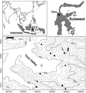
The study was conducted in the margin zone of the Lore Lindu National Park in Central Sulawesi, Indonesia. The study plots were located at lower montane elevations (800– 1140 m asl) in the vicinity of the village of Toro (1.50148S, 120.03558E). In accordance with traditional local management as put forward by the head of the village and endorsed by the head of the National Park authority (Helmi, 2005), we selected four forest use types. These were: (a) natural forest, (b) forest with extraction of small-diameter timbers (hereafter termed ‘small timber extraction’), (c) forest with selective extraction of large timbers (hereafter termed ‘large timber extraction’), and (d) cacao (Theobroma cacao) plantations under trees remaining from the natural forest (agroforest). We studied three replicates per use type. The natural forest was usually more distant to the Toro settlement (mean distance 1.8 km), than the more intensively used agroforest plots (0.8 km, Fig. 1). On the 12 plots, the slopes ranged between 178and 398and all expositions were represented (Table 1). In the natural forest, up to 63 tree species (10 cm dbh per 0.25 ha) were found with Meliaceae, Lauraceae, Sapotaceae, and Fagaceae having the highest share. The tree species richness was little affected by small timber extraction, but was lower in stands after large timber extraction (53 species per 0.25 ha) and lowest in the agroforest (32 species per 0.25 ha). The composition of tree species changed with use type and the proportion of endemics decreased towards the agroforest (Gradstein et al., in press).
In the study period, the annual mean temperature measured at an automatic weather station on the bottom of the Toro Valley
was 23.18C and the annual rainfall total was 1812 mm
(Kreilein et al., unpublished). At this station, the average rainfall intensity was relatively low (3.4 mm h 1,Table 2). As the valley bottom, where the automatic weather station was positioned, appeared to receive less precipitation than the surrounding slopes, we additionally deployed four manually gauged stations close to our study sites. There, the annual precipitation ranged from 2437 to 3424 mm. Toro is situated at a narrow part of Sulawesi and the open sea is within approximately 75 km to the east and west.
2.2. Stand characteristics
For all trees with a diameter at breast height (dbh) of 10 cm or more, dbh and height were measured on 1500 m2plots. To
account for smaller statured trees, all individuals with dbh<10 cm, but higher than 2 m, were assessed on three
randomly located subplots of 5 m5 m within the study plots. In the agroforest stands, all stems taller than 2 m were assessed. The dbh was measured with a tape and heights were taken with an ultrasonic hypsometer (Vertex III, Haglo¨f, La˚ngsele, Sweden). The presented results are corrected for slope.
Hemispherical photographs were taken vertically upward with a digital camera mounted on a leveling device (HemiView, Delta-T, Cambridge, UK). In each plot, photos were taken at three dates, on 30 randomly located points per plot and at a height of 1.5 m above the ground. The images were analyzed for canopy openness (WinScanopy, 2004a; Re´gent Instruments Inc., Sainte-Foy, Canada; opening angle of 308) and leaf area
Fig. 1. Location of the study plots in the surrounding of the village of Toro, Central Sulawesi (UTM 51 S). Indicated are natural forest plots (~), plots of small timber
extraction (&), plots of large timber extraction (^), agroforest plots (*), the permanent rain stations (), and the automatic weather station ( ).
Table 1
Geographical position and site characteristics of the study plots
Forest use type Abbr. UTM X 51S (m) UTM Y 51S (m) Elevation (m asl) Exposition Inclination (8)
Natural forest 1 NF 1 171250 9832974 948 SSE 32.2
Natural forest 4 NF 4 171759 9834927 1042 WNW 20.9
Natural forest 5 NF 5 168961 9835116 1130 NE 17.0
Small timber extraction 2 STE 2 171648 9832926 873 SSE 37.6
Small timber extraction 3 STE 3 169097 9835104 1078 NNE 31.2
Small timber extraction 4 STE 4 171550 9834710 982 W 33.2
Large timber extraction 1 LTE 1 169292 9834866 974 SSW 25.0
Large timber extraction 3 LTE 3 168716 9833262 827 W 35.0
Large timber extraction 4 LTE 4 170165 9834914 959 ESE 30.2
Agroforest 2 AF 2 169333 9833896 952 E 20.6
Agroforest 3 AF 3 169489 9834158 832 NNW 38.9
index (CanEye V 3.6, INRA, Avignon, France). We did not observe a seasonal pattern in either parameter (Dietz et al., in press-a) and thus based the following analyses on data obtained during a single measurement campaign (April 2005).
2.3. Gross rainfall, throughfall, and stemflow
Incident rainfall was measured adjacent to each of the 12 study plots with five bulk samplers per location. The localities for the measurements of gross precipitation were within a 150 m range from the study plots, situated at the same altitude and had the same aspect. The gauges were placed at a height of 100 cm in open area where trees or other taller objects were more than 35 m away. In other cases, where the openings were smaller, the bulk samplers were placed on 5 or 7 m tall bamboo structures. The collectors had an orifice of 295 cm2each and a vertical rim 3.5 cm high. A table tennis ball was placed in each of the funnels to reduce evaporation from the gauges. During measurement campaigns in the adjacent forest plots the rainfall volumes were measured daily.
Daily measurements of throughfall and stemflow were conducted in each of the study plots during campaigns for periods of about 24 days to record 15–17 days with detectable incident rainfall which coincides with measuring periods by Manfroi et al. (2006). These campaigns were conducted between June 2004 and March 2005. Throughfall was collected with 30 funnels per plot that were built identically to the rain gauges described above. They were installed at 100 cm above the ground. The throughfall collectors were arranged along three lines of each 50 m length, parallel to the contour with 10 m distance between the lines. On these lines the collector positions were defined by random with a minimum distance of 2 m between two samplers.
Stemflow was measured using spiral collars attached to 10 stems (10 cm in dbh) in each of the plots. Five of these trees reached the upper tree layer while the remaining trees were smaller. The trees of the upper tree layer were on average 29 m tall with a mean dbh of 45 cm while the sub-canopy trees were on average 22 m tall with a mean dbh of 15 cm. Stemflow volumes per unit ground area for the 1500 m2 plots were estimated from linear regressions (intercept = 0) between dbh and the stemflow volume per volume gross precipitation. These
J. Dietz et al. / Forest Ecology and Management 237 (2006) 170–178
T
Rainfall characteristics during the study period (April 5, 2004 to April 4, 2005) at the valley bottom close to the village of Toro (790 m asl; Kreilein et al., unpublished data)
Number of days observed 366
Number of days, Pg>0.2 mm 218 (60%)
Number of rain storms 526
Number of rain storms>0.2 mm 282 (54%)
Gross precipitation, Pg (mm) 1828
Average rain storm size (mm) 6.5
Average rain storm duration (h) 1.9
Average rainfall intensity,¯R(mm h 1) 3.4
Individual rainstorms were defined as precipitation events of more than the
minimum resolution of the tipping bucket rain gauge (i.e.>0.2 mm) and
regressions were established from trees of the three plots belonging to the same forest use type (usuallyn= 30 stemflow collectors per use type). The volume of stemflow significantly increased with dbh and the determinants of variation (r2) were 0.52 in the natural forest, 0.53 after small timber extraction, 0.34 after large timber extraction, and 0.30 in the agroforest. For trees<10 cm dbh the regression lines were extrapolated and the
stemflow volume per plot area was calculated on the basis of measured dbh and stem density. Because the sugar palmArenga
pinnata exceeded the stemflow yield of dicotyledonous trees
considerably, these three palms (one individual each in STE2, STE4, and AF3; seeTable 4) were always measured and not included into the regression analysis. Rather, their empirically determined stemflow volumes were included directly into the calculations where such palm was present in the research plot.
2.4. Statistical analysis
Multiple comparisons among group means for LAI were conducted with an analysis of variance (Duncan’s test); for throughfall the non-parametric Wilcoxon rank sum test (two-tailed) was applied. The relationships between rainfall partitioning and stand structural characteristics were analyzed using Spearman’s rank correlation and where applicable also simple and multiple linear regression models were used. The standard level of significance was P0.05. The statistical analyses were conducted with SAS software (SAS Institute Inc., Cary, NC, US; Version 8.2).
3. Results
3.1. Aboveground stand structure
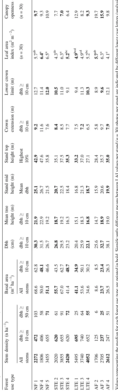
The median basal area of trees10 cm dbh decreased from 51 m2ha 1in the natural forest to 24 m2ha 1in the agroforest (Table 3). This was paralleled by a reduction in tree height. The mean height of trees10 cm dbh decreased from 22 to 17 m,
and the top height (height of the 10% thickest trees10 cm dbh) dropped from 43 to 33 m. The density of small stems was highest after large timber extraction (4052 stems per ha) and was relatively similar in the other forest use types (between 2272 and 2612 stems per ha). The average canopy openness, as determined from photographs taken at 1.5 m above the ground, was 10–11% per site in the natural forest and highest in cacao agroforest (between 10 and 20% in the three plots). Among stands of the same forest use type, the average LAI per plot showed a considerable variation. In the 12 plots, it ranged in from 6.5 m2m 2in a natural forest stand to 4.1 in an agroforest plot (Table 3).
3.2. Throughfall, stemflow, and interception
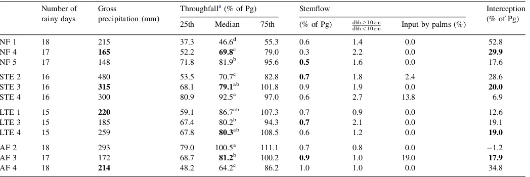
During the measurement campaigns which comprised of 15– 17 rain days each, a mean gross precipitation of 228 mm was observed (148–480 mm). In the four forest use types, the median of throughfall was lowest in natural forest (70% of Pg), and similarly high in all other use types (79–81%;Table 4). Among plots of the same type, the lowest variation in throughfall percentage was observed after large timber extraction (coefficient of variation 4%) and the highest in the natural forest (cv. 27%). Stemflow, including the exceptionally high input by sugar palms, was estimated with less than 1% of Pg in all studied use types. In our estimate, approximately 40% of all stemflow was contributed by stems smaller than 10 cm in diameter. The sugar palmA. pinnatahad three-fold higher stemflow values than dicotyledonous trees of the same size, but only three individuals of these trees were encountered (one individual each in STE2, STE4, and AF3; see Table 4). The calculated rainfall interception in the 12 plots ranged from virtually none ( 1% of Pg) in an agroforest to 53% in a natural forest. Interception was highest in the natural forest where as the median 30% of Pg were re-evaporated back into the atmosphere, and much less in the three other use types (18–20% of Pg).
Table 4
Rainfall partitioning in the 12 study plots
Number of rainy days
Gross
precipitation (mm)
Throughfalla(% of Pg) Stemflow Interception
(% of Pg)
25th Median 75th (% of Pg) dbh10 cm
dbh<10 cm Input by palms (%)
NF 1 18 215 37.3 46.6d 55.3 0.6 1.4 0.0 52.8
NF 4 17 165 52.2 69.8c 79.0 0.3 2.2 0.0 29.9
NF 5 17 148 71.8 81.9b 95.6 0.5 1.6 0.0 17.6
STE 2 16 480 53.5 70.7c 82.8 0.7 1.8 2.4 28.6
STE 3 16 315 68.1 79.1ab 101.8 0.9 1.9 0.0 20.0
STE 4 16 300 80.9 92.5a 97.0 0.6 2.7 13.8 6.9
LTE 1 15 220 59.1 86.7ab 107.3 0.7 0.9 0.0 12.6
LTE 3 15 185 67.4 80.2b 94.3 0.7 2.1 0.0 19.1
LTE 4 15 259 67.8 80.3ab 108.5 0.6 1.2 0.0 19.0
AF 2 18 293 79.0 100.5a 111.1 0.7 0.8 0.0 1.2
AF 3 17 172 68.7 81.2b 100.2 0.9 1.0 19.0 17.9
AF 4 18 214 48.2 64.2c 86.2 1.0 1.0 0.0 34.8
Values representing the median for each forest use type are printed in bold. Significantly different medians between research sites (n= 30) rainfall gauges per plot are
indicated by different lower case letters (Wilcoxon signed ranks test, two-tailed,P<0.05).
3.3. The relationship between stand structure and rainfall partitioning
Based on Spearman’s rank correlations it became evident that there were no significant correlations between topogra-phical parameters and rainfall partitioning for all 12 study plots (Table 5). The mean dbh of stems10 cm dbh correlated significantly with the throughfall percentage (Spearman’s rho= 0.69, Table 5). With increasing dbh the throughfall percentage decreased. The correlation consolidated when only days of strong precipitation (10 mm of Pg) are considered. Strong correlations were obtained between throughfall and all
parameters of tree height. The throughfall percentage increased significantly with decreasing tree height. Mean tree height (10 cm dbh) yielded a Spearman’s rho of 0.74 and stand mid
height of 0.71. Crown extension was only significantly
correlated to throughfall percentage when days with rainfall of more than 10 mm are included. The strongest correlation was observed between the lower crown limit (lowest point of ramification) and throughfall (Spearman’s rho = 0.83). Mean LAI and mean canopy openness alone were not significantly correlated with the median of throughfall percentage. However, a multiple linear regression with mean tree height (10 cm dbh) and mean LAI as parameters explained 81% of the variation observed in mean throughfall. As stemflow did not differ much among the study plots, the results on throughfall also apply to interception, which must also be closely correlated to tree height (Table 5andFig. 2).
4. Discussion
4.1. Stand structural characteristics
The basal area in the studied natural forest (median 51 m2ha 1) is higher than in most lowland forests studied by other authors. However, when compared to other natural forests above 600 m in elevation in the Southeast Asian region it is well within the reported range (Aiba and Kitayama, 2002; Brodbeck, 2004; Hamann et al., 1999; Kessler et al., 2005; Kitamura et al., 2005; Sri-Gernyuang et al., 2003). The stand basal area in our study region is sensitive to the forest use practice and was reduced by large timber extraction (41 m2ha 1), or by conversion to agroforest (24 m2ha 1).
J. Dietz et al. / Forest Ecology and Management 237 (2006) 170–178
Table 5
Spearman’s rank correlation coefficients (two-tailed) between rainfall partition components and stand structural characteristics for the 12 study plots
Throughfall (% of Pg) Interception (% of Pg)
Pg10 mm d 1 Pg>10 mm d 1 All days All days
Elevation (m asl) 0.02 0.40 0.32 0.32
Exposition (8) 0.13 0.13 0.03 0.03
Inclination (8) 0.19 0.50 0.36 0.36
Stem density
All stems (n ha 1) 0.13 0.24 0.16 0.16
dbh10 cm (n ha 1) 0.12 0.23 0.09 0.09
dbh50 cm (n ha 1) 0.39 0.31 0.39 0.39
Basal area
All stems (m2ha 1) 0.42 0.45 0.52 0.52
dbh10 cm (m2ha 1) 0.56 0.28 0.41 0.41
Dbh (dbh10 cm) (cm) 0.36 0.83*** 0.69* 0.60*
Mean tree height (dbh10 cm) (m) 0.58* 0.76** 0.74** 0.74**
Stand mid height (mean dbh) (m) 0.58* 0.69* 0.71** 0.71**
Stand top height (highest 10%) (m) 0.69* 0.52 0.51 0.51
Crown extension (m) 0.32 0.73** 0.61* 0.61*
Low crown limit (m) 0.71* 0.78** 0.83*** 0.83***
Leaf area index (m2m 2) 0.15 0.09 0.14 0.14
Canopy openness (%) 0.01 0.13 0.29 0.29
Significant correlations (P<0.05) are highlighted in bold.
* P<0.05.
** P<0.01.
***P<0.001.
Fig. 2. Rainfall interception as a function of mean tree height (dbh10 cm) in
As big and tall trees were harvested, tree height also decreased after large timber extraction. In Sulawesi, the average LAI of the natural forest plots ranged between 5.7 and 6.5, with a median at 6.4 m2m 2in this forest type. For natural forest in Amazonia, values between 3.6 and 6.6 were reported (Araga˜o et al., 2005), in Sumatra, Indonesia, between 3.9 and 6.1 (Trichton et al., 1998), and in Borneo, Malaysia between 4.8 and 6.8 (Kumagai et al., 2004). In a pan-tropical review, Roberts et al. (2004)collected LAI values ranging between 4.1 and 8.0 for lowland rainforests with a tendency of higher values in Asia. Thus, the values obtained on our study plots are well within the range of other studies. In Sulawesi, the LAI had reached its median at 5.2 in forest plots with small timber extraction, at 4.9 in forests with large timber extraction and at 5.7 in the agroforest. These data point to a relative quick recovery of LAI after disturbance. The relatively high LAI values in managed stands also compare well with results from Amazonia where only little differences in LAI between natural forests and selectively logged sites were observed (Araga˜o et al., 2005). The structure of individual plots within a forest use type varied and not always produced significant differences between those management types. However, the impact of management on the forest structure became evident, especially when comparing the managed to the natural forest plots.
4.2. Throughfall, stemflow, and interception
The annual gross precipitation (Pg) close to four of our study plots ranged between 2437 and 3424 mm. In the study plots we measured throughfall and stemflow for periods of 15–17 rainy days (see also Manfroi et al., 2006). In the natural forest, throughfall reached its median at 70% of Pg, stemflow was less than 1% and interception 30%. A similarly low stemflow fraction has also been observed in most tall old-growth forests, both in montane (Steinhardt, 1979) and lowland settings (Lloyd et al., 1988; Ubarana, 1996; Tobo´n Marin et al., 2000). Our value is slightly less than that observed in a lowland forest in Sarawak where stemflow was estimated at 3% of Pg (Manfroi et al., 2004) which may be due to the better representation of small statured trees in that stand. The observation, that palms (such asA. pinnata in our study) may have higher stemflow values than co-occurring trees has also been reported from other forest stands (e.g.Jordan and Heuveldop, 1981; Lloyd et al., 1988). Rainfall interception in the lower montane forest of Sulawesi is within the range observed for other montane forests not subject to substantial cloud incidence (20–37% of Pg; Bruijnzeel and Proctor, 1995; Bruijnzeel, 2001) as only very infrequent days of fog were observed in the Toro Valley, but the measured interception is higher than in lowland forests. In Southeast Asian lowland forests, high interception rates were reported for stands in Brunei and Sarawak close to the South
China Sea (Dykes, 1997; Kumagai et al., 2005) and the
prevailing maritime climate with a possible advection of energy may have contributed to this result.
In the forest plots under management, the rainfall interception was lower than in the natural forest (18–20% versus 30% of Pg). In one of the agroforestry stands, we even
found a higher sum of stemflow and throughfall than the
measured Pg (interception of 1%). As our measurement
scheme for throughfall and stemflow seems quite robust, a likely source of error is the less reliable measurement of gross precipitation which is a problem in many studies (Crockford and Richardson, 2000). For example, wind driven rain and contrasting atmospheric turbulence patterns above the stand and above the clearing may have caused a bias in the Pg data. As mentioned above, fog was rarely observed to form on the lower slopes around the Toro Valley where the study plots where located (personal observation). Thus, it is unlikely that intercepted fog may have contributed to exaggerated through-fall volumes on the study sites in question. In our study, we could not distinguish sources of error and thus opted to maintain the full observed data variability of results in the further analyses. On this basis, our data suggest that rainfall interception was reduced by logging from 30 to 18% of Pg. This shift confirms earlier results in a lowland forest in Kalimantan, where the rainfall interception was 11% in a natural forest and 6% in a logged forest (Asdak et al., 1998). On the other hand, our data seem to conflict with observations from Sabah, where interception was estimated with 8% of Pg in an undisturbed forest and with 15 and 19% of Pg in a logged forest (Chappell et al., 2001). In both studies, alterations in tree height and associated canopy roughness lengths by logging were seen as the major cause of the change in rainfall partitioning. Canopy roughness may influence the exchange of water and energy with the atmosphere and may lead to enhanced interception (Asdak et al., 1998) but can probably also increase the net rainfall volume (Chappell et al., 2001). Considering the existing studies it thus appears difficult to draw general conclusions on the effects of logging on rainfall partitioning.
4.3. The relationship between stand structural characteristics and rainfall partitioning
In our study, LAI alone did not correlate with throughfall. In contrast, stem density and especially tree height characteristics (mean height, mid height, top height, lower crown limit) were closely correlated to throughfall. A high r2 (0.81) was also obtained from a multiple linear regression with mean tree height and LAI as parameters. An explanation could be that the potential canopy water storage, to which leaf area contributes significantly, is not available at every rainfall event. For an other natural forest stand in Central Sulawesi, it was shown that during rainy periods of several weeks the canopy surfaces remained wet for more than 50% of the time (Dietz et al., in press-b). Thus, besides the size of the canopy water storage, its actual availability, which may be controlled by evaporation processes, is important as well. Taller trees are commonly associated with a greater roughness length of the stand which therefore receive a more effective turbulent energy exchange
with the atmosphere (e.g. Kelliher et al., 1993). As a
same direction was found in a montane forest of Costa Rica, where young secondary and old-growth forests differed greatly in rainfall interception but not in LAI, and the higher epiphyte abundance in the old-growth stand could not explain the observed differences (Ho¨lscher et al., 2004; Ko¨hler et al., 2006). The authors similarly suggested that a more effective energy exchange in the taller old-growth forest might have caused these patterns. The canopy roughness may also be of great importance for differences in rainfall interception between logged and unlogged forest (Asdak et al., 1998; Chappell et al., 2001). In Central Kalimantan, Asdak et al. (1998)found that logging reduced the rainfall interception and discussed the reduced roughness of logged stands as a probable cause. On the other hand, Chappell et al. (2001) found an increase in interception after logging and suggested that a higher roughness length may increase the energy exchange with the atmosphere leading to higher evaporation rates, while tall trees would also enhance the capture of falling rain drops from turbulent eddies and thus experience a higher precipitation than smaller trees. However, in our study region in Sulawesi, the effect of canopy roughness on evaporation (cf. Asdak et al., 1998) seems to be more important than any positive effect by large trees on precipitation (cf.Chappell et al., 2001). Thus, our results support the view by Asdak et al. (1998) that logging reduces the tree height, which may affect surface roughness, and consequently reduces the rainfall interception in tropical moist forests.
Acknowledgement
This study was conducted in the framework of the joint Indonesian-German research project ‘Stability of Tropical Rainforest Margins, Indonesia (STORMA)’ funded by the German Science Foundation (SFB 552, sub-project B4).
References
Aiba, S.I., Kitayama, K., 2002. Effects of the 1997–98 El Nin˜o drought on rain forests of Mount Kinabalu, Borneo. J. Trop. Ecol. 18, 215–230. Araga˜o, L.E.O.C., Shimabukuro, Y.E., Espı´rito Santo, F.D.B., Williams, M.,
2005. Landscape pattern and spatial variability of leaf area index in Eastern Amazonia. For. Ecol. Manage. 211, 240–256.
Archard, F., Eva, H.D., Stibig, H.J., Mayaoux, P., Gallego, J., Richards, T., Malingreau, J.P., 2002. Determination of deforestation rates of the world’s humid tropical forests. Science 297, 999–1002.
Asdak, C., Jarvis, P.G., van Gardingen, P., Fraser, A., 1998. Rainfall interception loss in unlogged and logged forest areas of Central Kalimantan, Indonesia. J. Hydrol. 206, 237–244.
Asner, G.P., Knapp, D.E., Broadbent, E.N., Oliveira, P.J.C., Keller, M., Silva, J.N., 2005. Selective logging in the Brazilian Amazon. Science 310, 480– 482.
Brodbeck, F., 2004. Structure and Processes in Traditional Forest Gardens of Central Sulawesi, Indonesia. Cuvillier Verlag, Go¨ttingen.
Bruijnzeel, L.A., 2001. Hydrology of tropical montane cloud forests: a reas-sessment. Land Use Water Resour. Res. 1, 1.1–1.18.
Bruijnzeel, L.A., Proctor, J., 1995. Hydrology and biochemistry of tropical montane cloud forests: what do we really know? In: Hamilton, L.S., Juvik, J.O., Scatena, F.N. (Eds.), Tropical Montane Cloud Forests, Ecological Studies 110. Springer, Berlin, pp. 38–78.
Chappell, N.A., Bidin, K., Tych, W., 2001. Modelling rainfall and canopy controls on net-precipitation beneath selectively-logged tropical forest. Plant Ecol. 153, 215–229.
Crockford, R.H., Richardson, D.P., 2000. Partitioning of rainfall into through-fall, stemflow and interception: effect of forest type, ground cover and climate. Hydrol. Process. 14, 2903–2920.
Dietz, J., Ho¨lscher, D., Leuschner, Ch., Malik, A., Amir, M.A. Forest structure as influenced by different types of community forestry in a lower montane rainforest of Central Sulawesi, Indonesia. In: Tscharntke, T., Leuschner, Ch., Guhardja, E., Zeller, M. (Eds.), The Stability of Tropical Rainforest Margins: Linking Ecological, Economic and Social Constraints of Land Use and Conservation. Springer, Berlin, Heidelberg, New York, in press-a. Dietz, J., Leuschner, Ch., Ho¨lscher, D., Kreilein, H. Vertical patterns and
duration of surface wetness in an old-growth tropical montane rainforest, Indonesia. Flora, in press-b.
Dykes, A.P., 1997. Rainfall interception from a lowland tropical rainforest in Brunei. J. Hydrol. 200, 260–279.
FAO (Food and Agriculture Organisation of the United Nations), 2001. Global Forest Resources Assessment 2000. FAO, Rome.
Fleischbein, K., Wilcke, W., Goller, R., Valarezo, C., Zech, W., Knoblich, K., 2005. Rainfall interception in a lower montane forest in Ecuador: effects of canopy properties. Hydrol. Process. 19, 1355–1371.
Gash, J.H.C., Lloyd, C.R., Lachaud, G., 1995. Estimating sparse forest rainfall interception with an analytical model. J. Hydrol. 170, 79–86.
Gradstein, S.R., Kessler, M., Pitopang, R. Tree species diversity relative to human land uses in tropical rain forest margins in Central Sulawesi. In: Tscharntke, T., Leuschner, Ch., Guhardja, E., Zeller, M. (Eds.), The Stability of Tropical Rainforest Margins: Linking Ecological, Economic and Social Constraints of Land Use and Conservation. Springer, Berlin, Heidelberg, New York, in press.
Grip, H., Fritsch, J.-M., Bruijnzeel, L.A., 2004. Soil and water impacts during forest conversion and stabilisation of new land use. In: Bonnell, M., Bruijnzeel, L.A. (Eds.), Forests, Water and People in the Humid Tropics. Cambridge University Press, Cambridge, pp. 561–589.
Hamann, A., Barbon, E.B., Curio, E., Madulid, D.A., 1999. A botanical inventory of a submontane tropical rainforest on Negros Island, Philippines. Biodiv. Conserv. 8, 1017–1031.
Herwitz, S.R., 1985. Interception storage capacities of tropical rainforest canopy trees. J. Hydrol. 77, 237–252.
Helmi, I., 2005. Local people are well-placed to develop zonation plans in Indonesia’s Lore Lindu National Park. Trop. For. Update 15, 31–32. Hodnett, M., da Silva, L.P., da Rocha, H., Cruz Senna, R., 1995. Seasonal soil
water storage changes beneath central Amazonian rainforest and pasture. J. Hydrol. 170, 233–254.
Ho¨lscher, D., Ko¨hler, L., van Dijk, A.I.J.M., Bruijnzeel, L.A., 2004. The importance of epiphytes to total rainfall interception by a tropical montane rainforest in Costa Rica. J. Hydrol. 292, 308–322.
Ho¨lscher, D., Mackensen, J., Roberts, J.M., 2005. Forest recovery in the humid tropics: changes in vegetation structure, nutrient pools and the hydrological cycle. In: Bonnell, M., Bruijnzeel, L.A. (Eds.), Forests, Water and People in the Humid Tropics. Cambridge University Press, Cambridge, pp. 598–621. Holwerda, F., Scatena, F.N., Bruijnzeel, L.A., 2006. Throughfall in a Puerto Rican lower montane rain forest: a comparison of sampling strategies. J. Hydrol. 327, 592–602.
Jordan, C.F., Heuveldop, J., 1981. The water budget of an Amazonian rain forest. Acta Amaz. 11, 87–92.
Kessler, M., Keßler, P.J.A., Gradstein, S.R., Bach, K., Schmull, M., Pitopang, R., 2005. Tree diversity in primary forests and different land use systems in Central Sulawesi, Indonesia. Biodiv. Conserv. 14, 547–560.
Kelliher, F.M., Leuning, R., Schulze, E.D., 1993. Evaporation and canopy characteristics of coniferous forests and grasslands. Oecologia 95, 153–163. Ko¨hler, L., Ho¨lscher, D., Leuschner, Ch., 2006. Above-ground water and nutrient fluxes in three successional stages of Costa Rican montane oak forest with contrasting of epiphyte abundance. In: Kappelle, M. (Ed.), E-cology and Conservation of Neotropical Montane Oak Forests. Springer, Berlin, pp. 271–282.
Kitamura, S., Suzuki, S., Yumoto, T., Chuailua, P., Plongmai, K., Poonswad, P., Noma, N., Maruhashi, T., Suckasam, C., 2005. A botanical inventory of a
tropical seasonal forest in Khao Yai National Park, Thailand: implications for fruit–frugivore interactions. Biodiv. Conserv. 14, 1241–1262. Kumagai, T., Katul, G.G., Saitoh, T.M., Sato, Y., Manfroi, O.J., Morooka, T.,
Ichie, T., Kuraji, K., Suzuki, M., Porporato, A., 2004. Water cycling in a Bornean tropical rain forest under current and projected precipitation scenarios. Water Resour. Res. 40, W01104.
Kumagai, T., Saitoh, T.M., Sato, Y., Takahashi, H., Manfroi, O.J., Morooka, T., Kuraji, K., Suzuki, M., Yasunari, T., Komatsu, H., 2005. Annual water balance and seasonality of evapotranspiration in a Bornean tropical rain-forest. Agric. For. Meteor. 128, 81–92.
Lloyd, C.R., Marques, A. de O.F., 1988. Spatial variability of throughfall and stemflow measurements in Amazonian rainforest. Agric. For. Meteor. 42, 63–73.
Manfroi, O.J., Koichiro, K., Suzuki, M., Tanaka, N., Kume, T., Nakagawa, M., Kumaigai, T., Nakashizuka, T., 2006. Comparison of conventionally
observed interception evaporation in a 100-m2subplot with that estimated
in a 4-ha area of the same Bornean lowland tropical forest. J. Hydrol. 329, 329–349.
Manfroi, O.J., Koichiro, K., Nobuaki, T., Masakazu, S., Nakagawa, M., Nakashizuka, T., Chong, L., 2004. The stemflow of trees in a Bornean lowland tropical forest. Hydrol. Process. 18, 2455–2474.
Roberts, J.M., Gash, J.H.C., Tani, M., Bruijnzeel, L.A., 2004. Controls on evaporation in lowland tropical rainforest. In: Bonnell, M., Bruijnzeel, L.A.
(Eds.), Forests, Water and People in the Humid Tropics. Cambridge University Press, Cambridge, pp. 287–313.
Sri-Gernyuang, K., Kanzaki, M., Mizuno, T., Noguchi, H., Teejuntuk, S., Sungpalee, C., Hara, M., Yamakura, T., Sahunalu, P., Dhanmanonda, P., Bunyavejchewin, S., 2003. Habitat differentiation of Lauraceae species in a tropical lower montane forest in northern Thailand. Ecol. Res. 18, 1–14.
Steinhardt, U., 1979. Untersuchungen u¨ber den Wasser- und Na¨hrstoffhaushalt eines andinen Wolkenwaldes in Venezuela. Go¨ttinger Bodenkundliche Berichte 56, Go¨ttingen, 185 pp.
Tobo´n Marin, C., Bouten, W., Sevink, J., 2000. Gross rainfall and its partitioning into throughfall, stemflow and evaporation of intercepted water in four forest ecosystems in western Amazonia. J. Hydrol. 237, 40–57. Trichton, V., Walter, J.M.N., Laumonier, Y., 1998. Identifying spatial patterns in
the tropical rain forest structure using hemispherical photographs. Plant Ecol. 137, 227–244.
Ubarana, V.N., 1996. Observations and modelling of rainfall interception at two experimental sites in Amazonia. In: Gash, J.H.C., Nobre, C.A., Roberts, J.M., Victoria, R.L. (Eds.), Amazonian Deforestation and Climate. John Wiley, Chichester, pp. 151–162.