accredited by DGHE (DIKTI), Decree No: 51/Dikti/Kep/2010 9
Wireless Sensor Network for Landslide Monitoring
in Nusa Tenggara Timur
Herry Z. Kotta1, Kalvein Rantelobo*2, Silvester Tena3, Gregorius Klau4
1,2,3
Faculty of Science and Engineering, Universitas Nusa Cendana, Penfui, Kupang, NTT
4
Dinas Pertambangan dan Energi Tk. I NTT, Kupang, NTT e-mail: [email protected], [email protected]*2
Abstrak
Tanah longsor di berbagai daerah telah merupakan bahaya serius secara substantsial bagi jiwa manusia dan kerugian material. Untuk menanggulangi dan mengurangi kerugian tersebut berbagai upaya untuk melakukan monitoring tanah longsor dikembangkan. Salah satunya yaitu memanfaatkan teknologi jaringan sensor nirkabel (JSN). Hasil yang didapatkan dari penelitian yang dilakukan di desa Ikanfoti, Kab. Kupang, Propinsi NTT (pada koordinat 10016’ 21.9 LS dan 123040’59.8 BT) sebagai tempat uji coba, memberikan hasil bahwa penerapan JSN dapat diterapkan dengan baik. Pengukuran sensor getaran (accelerometer) pada perangkat Micaz digunakan untuk mendeteksi getaran akibat adanya pergerakan tanah. Hasil dari penelitian ini menunjukan bahwa perubahan nilai accelleratror mulai dari 0,2g (gravity) sampai 0,49 g baik pada Accellerometert X maupun Y menandakan tanah mulai bergerak tapi belum secara signifikan. Nilai 0,5 g ke atas adalah nilai yang menunjukan perubahan pergerakan tanah secara signifikan. Mulai pada 1 g pergerakan tanah sudah mununjukan aktivitas yang sangat kuat dan sudah mengkuatirkan. Dari pemantauan pergerakan tanah dengan JSN ini diharapkan akan mengurangi kerugian akibat bencana geologi tanah longsor khususnya di NTT. Diharapkan penelitian ini memberikan landasan bagi penerapan JSN di berbagai daerah di NTT dan Indonesia pada umumnya.
Kata kunci: accelerometer, jaringan sensor nirkabel (JSN), Micaz, pemantauan tanah longsor
Abstract
Landslides in many regions constitute serious hazards that cause substantial life and financial losses. To overcome and reduce the damages, efforts to monitor landslides are developed. One such technology utilizes a wireless sensor network (WSN). Results obtained from studies conducted in the Ikanfoti village, Kupang District, Nusa Tenggara Timur (NTT) Province (S 10o16’ 21.9” and E 123o40’59.8”) as pilot project, give result that the application of WSN can be applied properly. We detect and measure vibrations caused by landslides by vibration sensor (accelerometer) on Micaz devices. The results of this study indicate that changes in accelerometer values ranging from 0.2 g (gravity) to 0.49 g of either the X or Y of accelerometer indicate that soil begins to move but not significantly. Value above 0.5 g is a value that indicating a significant change of ground motion. The value of 1 g and above of ground motion indicates a very strong activity and should be alarmed. It is expected that this research provides the foundation for the application of WSN in various areas in NTT Province and Indonesia in general, for establishing thorough and reliable early warning system (EWS).
Keywords: accelerometer, landslide monitoring, Micaz, wireless sensor network (WSN)
1. Introduction
Within few years, the earth's population has increased very sharply, causes human need more land to live: (a) people in poor countries are beginning to explore mountains to live and farm, (b) people of rich countries are moving into areas of high to get peace and comfortable place to live. As a result, settlements occupy steep areas, which previously resulted in movement of land every year in all corners of the world. Losses suffered from movement of landslides for one year is equal to the damage caused by the earthquake for 20 years.
In this paper, a landslide detection system was designing using wireless sensor network (WSN) very steep ramps up towards the foot of the slope exceeding the balance of power that hold its slopes.). Landslide in this activity refers is defined as the mass movement of land (including rocks), layer of sedimentary deposit that has not consolidated or layer of soil on the slopes that are very steep ramps up towards the foot of the slope exceeding the balance of power that hold its slopes.
Application of WSN technology for landslide mitigation of geological hazards has grown rapidly. The development is based on the character of WSN which are easily developed and relatively economical. The use of conventional sensor technology often encounters difficulties in data collection that came from the characteristics of landslides, causing some problems in research to predict and detect landslides. The presence of WSN provides simplicities in the measurement of field data, and makes the landslide prediction system becomes more effective. The main reason behind the use of wireless sensor networks is the flexibility in data density, easy long-distance communications to various points, improving overall accuracy, and the capability of real time control. WSN is a group of smart sensors, where each point of sensor has the capability for sensing, processing and communicating, but if they are developed in terms of numbers or connected to each other into networks, they will be able to function as the monitor of a physical state of the earth collectively. WSN is a new generation of sensor systems, although still limited in data processing capability and bandwidth for communication [1].
Various studies related to ground motion with different focus had already been done. Among others [2] - [7], Jamaludin et al [2] analyzed the temperature of the soil and slope conditions, [3] and [4] focused on the detection of a prototype model, while [5] - [7] tried a WSN test bed for real-time measurement.
To the best of our knowledge, research on WSN and its prototype in the area of montmorillonite (expansive clays) has not been well studying yet. This research attempts to contribute to the implementation of WSN, not only the prototype model, but also to compare it with direct measurements at the test site research. This research is a continuation of previous research [8] of the geographic information systems (GIS) application for settlement of the hill zone on Nusa Tenggara Timur (NTT) Province. The expected contribution of this research will be useful in integrating the GIS system in an early warning system (EWS) [9] - [11].
2. Research Method
2.1 Accelerometer Data Analysis
Accelerometer reads a biaxial acceleration changes by providing a large voltage difference Vout, so that to know how much the angle changes that occur by using formula below
S
V
: Offset voltage power supply (0.4 V)S
: Sensitivity accelerometer (167 mV / G, 17%)Accelerometer works by sending high-level analog signals in terms of stress (voltage) proportional to the acceleration measurements. Sensing mechanism of the accelerometer is described as
Vout = (Scale_factor * Acceleration) + Offset_voltage (2)
where:
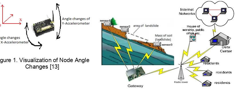
The generated value of accelerometer, X and Y, show the changes in horizontal and vertical angle. In other words, the value of the accelerometer node X means changing corner to the left and right according to the X-axis, while the value of Y means that node changes accelerometer with vertical slope as Y-axis. Figure 1 shows a visual representation of the movement of nodes in the event of changes in accelerometer X and Y.
Figure 1. Visualization of Node Angle Changes [13]
Figure 2. Measurement and monitoring of real-time data landslides as a real-time system (refer to [7])
2.2 WSN Configuration on data collection
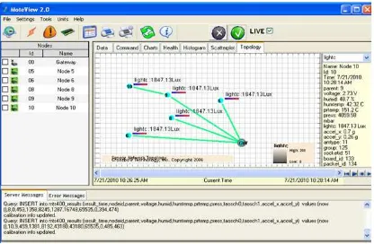
In this research, the using ad-hoc type of network topology similar to [12]. This is a type of network topology in which a central 'root' node (the top level of the hierarchy) is connected to one or more other nodes that are one level lower in the hierarchy (i.e., the second level) with a point-to-point link between each of the second level nodes and the top level central 'root' node. While each of the second level nodes that are connected to the top level central 'root' node will also have one or more other nodes that are one level lower in the hierarchy (i.e., the third level) connected to it. Gateway that provides link between sensors and central processor acts as root, and nodes refer to every sensor in the system. Actually, every node can send data directly to gateway, but in certain case when link between one node to gateway is broken, it can send data via other node (ad-hoc).
The landslides monitoring in real-time system, that be used as the scheme in this research, is shown in Figure 2.
3. Results and Analysis
3.1 Measurement and Data Analysis
Measurement using a prototype is intended to facilitate analysis of data on various conditions. Simulation of the movement of land to see the avalanche effect is done manually by stressing the ground. Output of MoteView software [13], [14] which is used in this work is shown in Figure 3. It uses formula (1) that directly converted into the MoteView analysis software. The results of direct analysis in graphical form for each condition are shown in Figure 4.
The analysis of each data using a prototype is as follows:
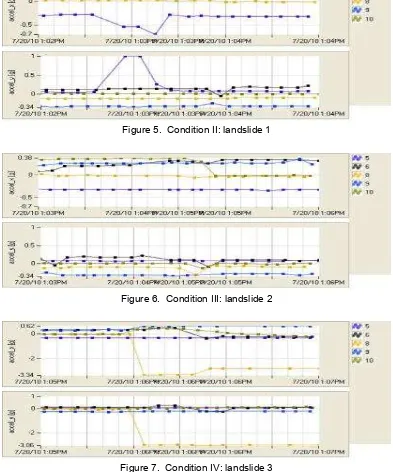
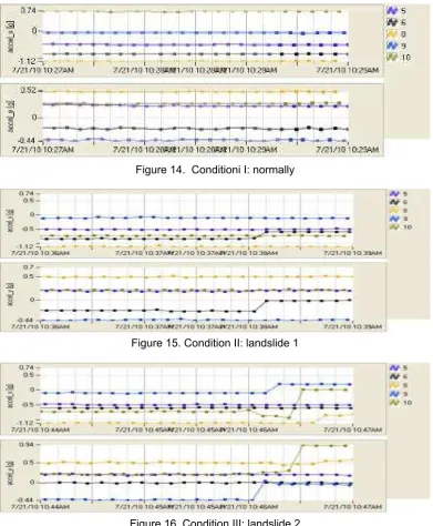
a. Condition I: the normal condition (before the forced movement of landslide) is depicted in Figure 4. It appears that all nodes (sensors), 5, 6, 8, 9 and 10 remained unchanged in both X and Y accelerator data.
b. Condition II: the condition that is affected by ground movement (landslides 1) depicted in Figure 5. This figure shows that node 5 from time 13:02 to 13:03 subject to change, the change position of x accelerometer, approximately -0.3 to -0.7 g while in y accelerometer changed significantly from position 0 to +1 g. There are visible but not significant changes in node 6 and 9.
changing from +0.38 to 0 g, while y accelerometer is changing position from 0 to about -0.1 g.
Figure 3. The topology of WSN on the data retrieval
d. Condition IV: the condition that is affected by soil movement (landslides 3) depicted in Figure 7. At node 8 from time 13:05 to 13:06 of significant change, in x accelerometer it changed position from 0 to 3.34 g while in y accelerometer it changed position from 0 to -0.306 g. Node 6 experienced no significant change.
e. Condition V: the condition that is affected by ground movement (landslides 4) depicted in Figure 8. In this condition, node 9 and 10 from time 13:08 until 13:09 of not significant change.
f. Conditions VI: the condition that is affected by ground movement (landslides 5) depicted in Figure 9. It seems that nodes 9 and 10 change from time 13:09 until 13:10 but not significantly. At node 9: both x and y accelerometer is changing position from -0.2 to -0.1 g. At node 10: both x and y accelerometer are changing position from 0.22 to 0.1 g.
g. Condition VII: the condition that is affected by ground movement (landslides 6) depicted in figure 10. It appears that only node 9 from time 13:11 until 13:12 of significant changes. X accelerometer unchanged while y accelerometer changed position from -0.2 to -0.1 g. At node 10: both x and y accelerometer are unchanged.
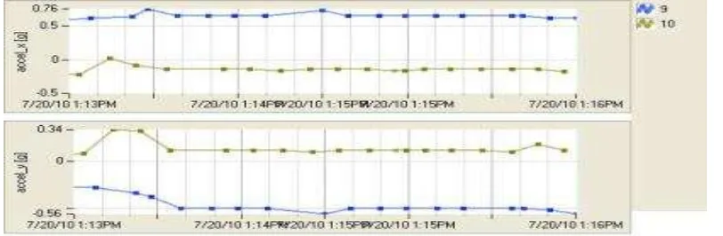
h. Condition VIII: the condition that is affected by ground movement (landslides 7) illustrated in Figure 11. It appears that both nodes 9 and 10 from time 13:13 until 13:14 of change, the x accelerometer changed although not significant, and y accelerometer at node 9 changes of positions +0.1 to +0.34 g; at node 10 changes from y accelerometer position -0.3 to -0.56 g. i. Condition IX: the condition that is affected by ground movement (landslides 8) illustrated in
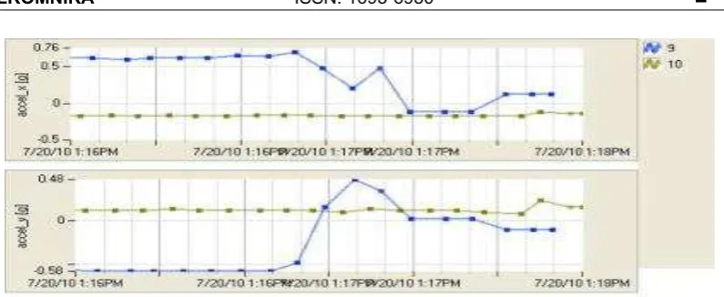
Figure 12. It appears that only node 9 from time 13:16 until 13:17of change, change of position x accelerometer 0.7 to -0.1 g, while the change of position y accelerometer -0.6 to +0.48 g.
Figure 4. Condition I: normal
Figure 5. Condition II: landslide 1
Figure 6. Condition III: landslide 2
Figure 8. Condition V: landslide 4
Figure 9. Condition VI: landslide 5
Figure10. Condition VII: landslide 6
Figure 12. Condition IX: landslide 8
Figure 13. Condition X: landslide 9
From those data, it appears that changes in accelerometer values ranging from 0.2g (gravity) to 0.49g in both X and Y indicates soil has begun to move but not significantly. The value of 0.5 g or more is a value that indicating a significant change of ground motion. Starting on 1 g of ground motion indicates a very strong signal activity and should be alarmed. These results will be demonstrated and tested on a sample of research sites in the Ikanfoti village, Kupang District, Nusa Tenggara Timur Province (10o 16’ 21.9” LS and 123o 40’ 59,8” BT).
3.2 Experiments and Analysis on Test bed Location
The test bed or test site is located at Ikanfoti village, Kupang District, East Nusa Tenggara Province on 10o 16’ 21.9” LS and 123o 40' 59.8” BT (as Pilot Project). The primary consideration of the site location that prepared by Bobonaro Complex Formation is that the site consists of clay mineral or montmorillonite(expansive clays) and rock. Such sites are regionally widespread and can represent the general condition of the area in NTT.
Analysis of each data measurement is as follows:
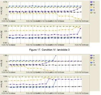
a. Condition I: the normal condition (before the enforced movement of landslide) is depicted in Figure 14. It appears that all the nodes (sensors), 5, 6, 8, 9 and 10 remained unchanged in both X and Y accelerometer.
b. Condition II: the condition that is affected by ground movement (landslides 1) depicted in Figure 15. It can be seen that only node 6 subject to change from time 10:37 to 10:38. The change position of x accelerometer approximately -0.8 to -0.6 g while the y accelerometer have -0.25 to about 0 g.
d. Condition IV: the condition that is affected by soil movement (landslides 3) depicted in Figure 17. It appears that only nodes 5 and 8 from time 10:49 to 10:50 are subjected to change. At node 5, the x accelerometer changed position to 0 -0.5 g while in y accelerometer changed from position 0.2 to 0.7 g. Node 8 are changing position, for x accelerometer until the position -1.58 to -0.9 g; while the y accelerometer changed from 0.6 to about 0.8 g. e. Condition V: the condition that is affected by ground movement (landslides 4) depicted in
Figure 18. It can be seen that nodes 5, 8 and 9 from time 10:51 to 10:52 are subjected to change. At node 5; the x accelerometer changed position from 0 -0.5 g to 0.2 g, while y accelerometer to 0.7 g. For node 8; x accelerometer appears to change from position -1.57g to -0.9 g while in y accelerometer change from 0.6 g to 0.8 g. The signal node 8 ends at 10:51. For node 9; the x accelerometer change to position 1g 0.1 (significantly) while y accelerometer from -0.1 g to 0.6 g. Signal node 9 also seems to have subsided around the time of 10:51. Nodes 6 and 10 just still provide a constant signal (no change). The termination or loss of signal nodes 5 and 9 caused by significant ground motion, so nodes can no longer emit a signal to the gateway/network.
Figure 14. Conditioni I: normally
Figure 15. Condition II: landslide 1
Figure 17. Condition IV: landslide 3
Figure 18. Condition V: landslide 4
The research has been done using either a prototype or sample of measurements directly on the site, giving the result that the application of WSN can be applied properly. The value of x and y accelerometer (Micaz device) are used to detect vibrations caused by ground movement in landslide area. The results of this works indicate that changes accelerometer values ranging from 0.2 g to 0.49 g in both x and y accelerometer indicates soil begin to move but not significantly. Above 0.5 g is a value that indicating a significant change of landslide. Starting on 1 g and above of landslide have a very strong signal activity and should be alarmed. This condition will be interpreted by Early Warning System (SPD) as a danger condition and to give signal to the community surrounding the location of landslides area [8].
4. Conclusion
Acknowledgments
This research was funded by Directorate General of Higher Education (DGHE), Ministry of National Education Republic of Indonesia (Hibah Kompetensi Batch II 2010). Thanks are also addressed to Dr. Wirawan, DEA and Prof. Dr. Tsuyoshi Usagawa as peers, the PREDICT and Lab. Multimedia Telecommunications of ITS, Lab. UNDANA Mining Engineering, Energy and Mining Department of NTT Province, and the various parties involved in this works.
References
[1] Wirawan, Rachman S, Pratomo I, Mita N. Design of Low Cost Wireless Sensor Networks - Based Environmental Monitoring System for Developing Country. Proc. Int. Conference APCC 14th Asia-Pacific. Tokyo, Japan. 2008; 1-5.
[2] Jamaludin MZ, Aripin NM, Isa AM, Mohamed HWL. Wireless Soil Temperature and Slope Inclination Sensors for Slope Monitoring System. Proceedings of International Conference on Energy and Environment (ICEE). Selangor, Malaysia. 2006.
[3] Maneesha V Ramesh, Sangeeth Kumar, P Venkat Rangan. Wireless Sensor Network for Landslide Detection. Proceedings of the 2009 International Conference on Wireless Networks (ICWN). Las Vegas Nevada, USA. 2009; 2: 89-95.
[4] Wang Rixu. Nie Lei. The Design and Application of Time Prediction and Spatial Prediction in Fushun West Open Pit Landslide Monitoring and Prediction System. Proc. Int. Conference Second WRI Global Congress on Intelligent Systems. Xiamen, China. 2010; 3-7.
[5] Ryan Ditya Permadi. Simulasi Sistem Deteksi Tanah Longsor dengan Jaringan Sensor Nirkabel. Final Project. Surabaya: Electrical Engineering ITS. 2009.
[6] Cesare Alippi, Romolo Camplani, Cristian Galperti, Manuel Roveri. Effective design of WSNs: from the lab to the real world. Proceeding of IEEE International Conference on Sensing Technology (ICST) 3rd. Taipe, Taiwan. 2008; 1-9.
[7] Jungwoo Lee M S, Real-time Monitoring of Landslide using Wireless Sensor Network. PhD Thesis. Ohio: The Ohio State University; 2009.
[8] Herry Z Kotta, Silvester Tena, Gregorius Klau, K Rantelobo. Application of Geographical Information System (GIS) for Mapping Landslide Susceptibility: A Case Study of Timor Tengah Selatan, NTT Province. Proceedings of National Seminar on Applied Technology, Science, and Arts (1st APTECS). Surabaya. 2009; 13-17.
[9] Chuanhua Zhu, Xueping Wang. Landslide Susceptibility Mapping: A Comparison of Information and Weights-of-Evidence Methods in Three Gorges Area. International Conference on Environmental Science and Information Application Technology. Wuhan, China. 2009; 342-346.
[10] Kyoji Sassa. Editors. Landslide: Risk Analysis and Sustainable Disaster Management. Proceeding of Firet General Assembly of the Int. Consortium on Landslide. Springer-Berlin. NY. 2005.
[11] WEN Hai-jia, LI Xin, ZHANG Jia-lan. An Evaluation-Management Information System of High Slope Geo-risk for Mountainous City Based on GIS. International Conference on Information Science and Engineering (ICISE). Nanjing, China. 2009; 1976-1978.
[12] Karl Holger, Willig Andreas. Protocols and Architectures for Wireless Sensor Networks. John Willey and Sons. 2005.