IJG Vol. 45, No.1, June 2013 (1- 14) © 2013 Faculty of Geography UGM and The Indonesian Geographers Association
MANAGING FLOOD RISKS: LESSONS FROM KEKO MACHUNGWA
INFORMAL SETTLEMENT IN DAR ES SALAAM, TANZANIA
Tumpale Sakijege
tumpaleg@yahoo.com
Department of Urban and Regional Planning, Ardhi University of Tanzania
ABSTRACT
Globally, world urban population has been increasing and by 2050 it is expected to reach 70% of the world population. This is a challenge because new settlements are emerging and most of them are taking place informally in developing countries. Forms of urbanization in developing countries are not in favor of poor people. As a result, majorities are forced to reside informally in areas prone to natural hazards in general and floods in particular. Literatures prove that informal settlements are a major factor in the increase of floods because most of them lack of basic infrastructures and there is poor coordination from the development activities. These together contribute to the increase of vulnerability of informal settlement inhabitants into different risks associated with floods as a result of climatic change. The paper therefore assesses surroundings of informal settlements under the umbrella of factors that cause risks and how they are managed and spell out relevant policy implications. Findings show that factors that increase flood associated risks in the settlement include: housing densification, solid waste management, sewers and drains management, blocked streams, water sources, livestock keeping, and accessibility.
Key words: Informal settlements, Keko Machungwa, floods and risks.
ABSTRAK
Secara global, populasi penduduk perkotaan di dunia telah meningkat dan pada tahun 2050 diperkirakan mencapai 70% dari total penduduk dunia. Hal ini merupakan tantangan karena permukiman-permukiman baru bermunculan dan sebagian besar merupakan permukiman informal di negara berkembang. Bentuk-bentuk urbanisasi di negara berkembang pada umumnya tidak berpihak pada masyarakat miskin. Sebagai hasilnya, sebagian besar terpaksa tinggal pada permukiman informal pada daerah rawan bencana, terutama banjir. Literatur-literatur membuktikan bahwa permukiman informal, sebagai hasil dari pertumbuhan urbanisasi yang cepat, merupakan faktor utama dalam meningkatnya banjir karena sebagian dari mereka kekurangan dalam hal infrastruktur dasar dan lemahnya koordinasi dari aktivitas-aktivitas pembangunan. Faktor-faktor ini secara bersamaan berkontribusi terhadap meningkatnya kerentanan penduduk pada permukiman informal kedalam berbagai risiko yang berbeda terkait dengan banjir sebagai dampak dari perubahan iklim. Tulisan ini bertujuan untuk mengidentifikasi kondisi lingkungan sekitar permukiman informal dalam payung berupa faktor-faktor yang berpengaruh terhadap risiko dan bagaimana mereka mengatur dan memutuskan implikasi kebijakan yang relevan. Hasil penelitian menunjukan faktor-faktor yang terkait dengan risiko banjir di permukiman antara lain terdiri dari: meningkatnya kepadatan bangunan, pengelolaan limbah padat, pengelolaan saluran limbah dan drainase, sungai yang terhambat, sumber air, pemeliharaan ternak, dan aksesbilitas.
INTRODUCTION
Globally, floods have occurred in the past centuries and are recurring in many cases
[Nijland, 2005 and Daze, et. al. 2009].
However, flooding is predicted to become more frequent and acute in future. This is due to sea level rise, climate change, and land subsidence [Hochrainer 2006 citing
Miller and Keipi 2005, and UN-Habitat
2009]. Indeed there is evident that flooding is getting more serious over time, in terms of the number of floods and the damage
[Munich Re, 2005]. Flooding and
associated risks will continue to affect our society because it is exaggerated by climatic change. Climate change is one of the major environmental challenges facing the world today and pressing threat to the development [UNDP 2004, UN-Habitat 2009]. Climate change is a global problem that should be addressed at every level of
society, from the household to businesses andgovernment [Rowlands, 2006 citing Defra, 2006].
Compared with developed countries, developing countries do experience fewer natural disasters in general and flood in particular than developed ones, but they are the one who suffer the most
[Hochrainer, 2006 citing Kahn, 2005].
The major factor contributing to the magnified impact of flood disasters in developing countries is the lack of development itself, which makes it impossible not only for citizens to adhere the building regulations, but also for authorities to enforce them to avoid uncontrolled urbanization [UN-Habitat,
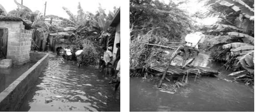
2009]. Current forms of urbanization are not in favor of poor people, as result majorities are pushed into locations that are prone to natural hazards (see Figure 1).
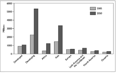
Each day, 193,107 new urban dwellers are added to the world’s urban population (UN-Habitat 2009) and it is expected to increase for the next decades [OECD, 2006]. The world urban population is projected [OECD, 2011] to reach 70% of the world population by 2050 (see also Figure 2). This challenge is compounded by the fact that most of these settlements are taking place informally [UN-Habitat, 2006]. Growth of informal settlements as a result of rapid urbanization is a major factor in the increase of floods [Benouar 2002, Adelekan, 2011]. This is reaffirmed
by Parker [1999] who noted that
urbanization worsens floods by diminishing the permeability of ground surfaces and increasing runoff rates.
Keko Machungwa settlement is one of the informal settlements in Dar es Salaam City. The informal settlements in Dar es Salaam City, up to the 1940s, were only few. However, after independence in 1961, the number and character of these
settlements changed rapidly. By 1979, 2,349 hectares of land (or nearly 40% of the city’s residential land) were occupied by 25 informal settlements. This figure had increased to 40 settlements in 1990, covering 5,000 hectares of the area. In 2000, estimation indicates that this number has increased to 50 settlements [Lupala, 2002] and 54 in 2005. Another recent study [URT, 2012] pointed that informal settlements now cover 125; 226; 87 square kilometers area in Ilala, Kinondoni and Tameke respectively (see Table 1). This makes a total of 438 sq km (equivalent to 29% of total land).
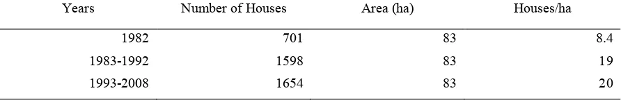
For the case of Keko Machungwa settlement in 1982, there were a total of 701 houses constructed, making a housing density of 8.4 houses/ha. It is important to note that flooding by then was not a serious problem as low housing density permitted percolation of rainwater and free movement of water through the natural
drainage systems.
Table 1. Approximate Land-use Coverage 2011 (km2)
Municipality Planned Un-Planned Un-Built Water
bodies Total % of total
Ilala 91 125 103 0 319 21
Kinondoni 118 226 162 2 508 34
Temeke 66 87 521 11 685 45
Total 275 438 786 13 1,512 100
% of total 18 29 52 1 100
Source: URT 2012
The Urbanization trends in the 1990s led to
rapid development of informal housing (see Figure 3) within the area, by 1,992 houses increased to 1,598, made a housing density of 19 houses/ha. This was triggered by free market economy in Tanzania. The number of people who were seeking employment opportunities at Chang’ombe Industrial area as well as preference to live near the CBD (working place) increased tremendously, leading to intensification of land subdivision for housing development. By the end of 2008 there were 1,654 houses in the area with an overall density of 20 houses/ha.
This higher rate of housing densification (see Table 2) without investing in drainage system created a major flooding problem
and consequently caused risk to the inhabitants. A good example is the impact on health. Health related complications are among the most significant effects of flood although it is very difficult to quantify because some of the disease may not be revealed until long after the flood season is over [Kolsky, 1999]. Therefore the
objectives of this paper are twofold: firstly is to assess surroundings of informal settlements under the umbrella of factors that cause risks and how they are managed. The underlying assumption is that factors causing risks in climatic change era, if not taken into account, will result to severe damages to health of human beings and loss of nation work force in a long run. Secondly is to spell out the relevant policy implications.
Table 2. Housing Densification in Keko Machungwa (1982-2009)
Years Number of Houses Area (ha) Houses/ha
1982 701 83 8.4
1983-1992 1598 83 19
1993-2008 1654 83 20
Figure 3. Informal housing development in Keko Machungwa (Google earth view 2012)
THE METHODS
The study employed case study method by selecting Keko Machungwa settlement as a case study area. The settlement has a total
number of 3,024 households. A total number of 75 households were randomly
selected for interview. This sample size was obtained through the following formula.
(1)
Where: P = population proportion, p = 0.5 (which in fact gives the optimal value of the sample size n), e= 0.1, =10% (90% confidence interval), Z /2 = 1.645, N= Sampling frame, N= 3024. Therefore the sample size was 75 households. The methods for data collection included questionnaires that were administered to the identified and selected households,
literature review, official interview, observation and photographic registration.
Geographical Location
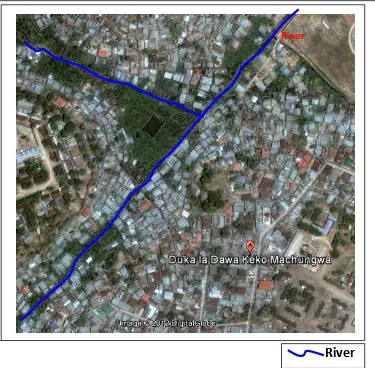
Geographically, Keko Machungwa settlement is situated about 3 kilometers from the Dar es Salaam City center (see Figure 4). It stretches along Kilwa Road and has mixed activities (residential, commercial and institutional). Keko Machungwa is one of the sub-wards within Mibulani Ward, Temeke Municipality. This area apart from being developed haphazardly, also has a flat topography and receives rain water from the surrounding settlements which are on a higher elevation and therefore increase vulnerability of the settlements.
River
2 2 / 2
2 2 /
)
1
(
N
e
pqZ
pq
NZ
n
Figure 4. Keko Machungwa in Dar es Salaam City [URT, 2004]
RESULTS AND DISCUSSION
Housing Densification
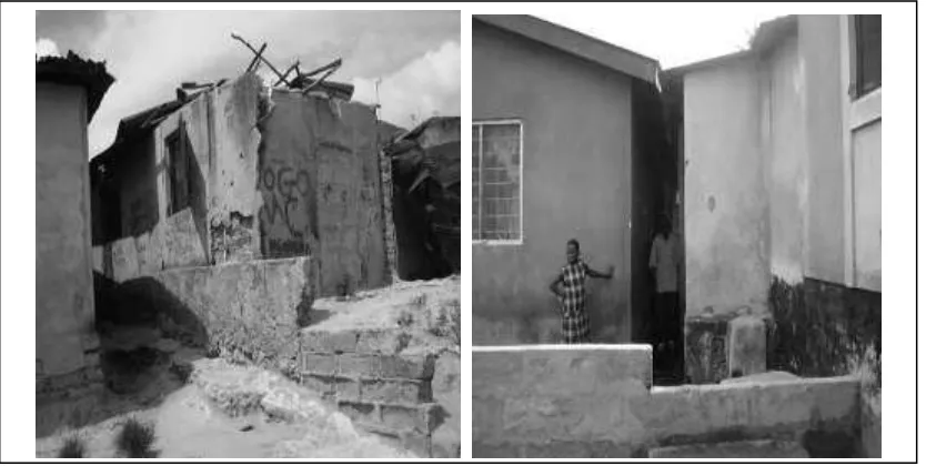
Housing densification is one of the reasons which exaggerate flood associated risk in Keko Machungwa. It is common within the settlement to find houses with different sizes, ranging from one room, two rooms, three rooms and up to 12 rooms for Swahili types of houses. During interview, 68% of the respondents complained that houses have been constructed very close to each other (see Figure 5) to the extent of limiting access, and badly enough, any open area is covered by houses. One respondent said “it is now difficult to get a place to build a house”. This is like to say that the settlement is now full. In an
environment of a changing climate, this situation exaggerates the flood problem because rain water will be blocked; causing floods and hence causes risks to the inhabitants.
Figure 5. Houses very close to each other with very limited access
Solid waste management
One of the sub-ward leader in the settlement complained that there is no good response from the residents on the issue of managing solid wastes. They have tried to organize the residents; each household is supposed to contribute 1,000 Tsh per month for solid waste collection. However the response is very poor and discouraging. Some residents cannot afford paying the amount for solid waste asked to explain where she disposes wastes she answered “To the river”. In addition to the river stream, there is accumulation of wastes in different places within the settlement which block water flow. The accumulated heaps of wastes tend to decompose and smell badly. In that state, decomposing and stinking wastes increase the vulnerability of the inhabitants to different diseases. It is obvious that during rainfall, solid wastes apart from blocking
the flow of water. They also spread to settlement and increase health risks.
Sewers and drains management
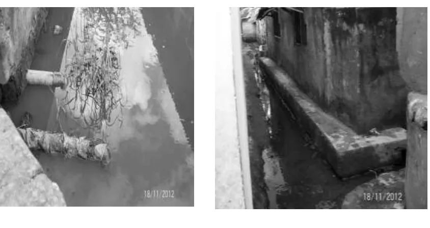
Sewers and drains are important for accommodating wastewater and storm water. If they are well designed and constructed, they have the potential to minimize problems to human life and the environment. In Keko Machungwa this situation is hard to attain because the settlement has a serious problem of storm water and waste water drainage system. This is not a surprise; it is a common situation that applies across all informal settlements in Tanzania. Individual inhabitants of informal settlements have been left to manage sewerage and waste water on their own. It was revealed through interview that 73% of the household use pit-latrines, and due to absence of functional sewerage management system, households directly discharge “raw-human waste” into drains or river streams within the settlement whenever it rains (see Figure 6a). This is very dangerous bearing in mind that during rainfall the river stream in Keko overflows and inundates the surroundings.
a) b) Figure 6. a) Pipe from a pit-latrine directed to a stream and b) Water lodging in drainage
channel constructed by individual households
In order to manage storm water, individuals organized several efforts to construct drainage channels within their surroundings. However, such drains constructed on individual initiatives are not coordinated. This again causes another problem of water lodging (Figure 6b) and increase breeding grounds for mosquitoes because the construction is done by local builders (as it was revealed by 85% of the interviewed households) who don’t have knowledge on the speciation of material and slope. It was revealed through observation and discussion with the local leaders that, within the settlement there is ongoing construction of one drainage channel. This is a good achievement; however it is done by a private company to protect his area from flooding while the rest of the settlement will continue to be affected by floods. It is obvious in rainy season to find large part of the area flooded. Such areas include houses and pit
latrines. Floodwater spreads human excreta from toilets to the surrounding and thus increase settlement vulnerability to different diseases.
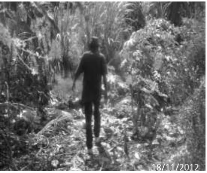
Blocked streams
a) b)
Figure 7. a) Solid waste blocking water channel and b) Blocked parts of the stream turned into pathway
a) b)
Figure 7. a) Solid waste blocking water channel and b) Blocked parts of the stream turned into pathway
Water sources
Within the settlements there are two types of water sources. The first one is piped water supply which is under DAWASCO
and it is an effort of individual household to connect to it. The second water source is boreholes or simply water wells. Although the majority of household (78%) collect water from boreholes, this water is not safe given the fact that the settlement lacks a functional sewerage and wastewater management system. Most of the wells are very close to the stream (0.1 m). During rainy seasons you cannot determine the location of these wells because they become covered with storm water. This is very risk in terms of health. According to
Sakijege et al, [2012], water from the bore
holes has 14 counts/100 mL and 23 counts/100 mL for faecal and total coliforms respectively. In addition the results of interviews held with medical
officers from dispensaries within the settlement also indicated that waterborne diseases are among the leading diseases affecting the residents.
On the other hand those who access piped water complain about the poor system of water connection done by the responsible authority. One of the interviewed household said that “I have piped water but I don’t trust it because the pipe pass through the stream and sometime the pile bursts and water in it gets mixed with dirty contaminated stream water”. This statement was reaffirmed through observation in different part of the settlement (see Figure 8). It can be seen clearly from the photo that clean water in the pipes that pass through the stream can easily get contaminated by the dirty water in the stream.
Figure 8. Water pipes crossing the stream
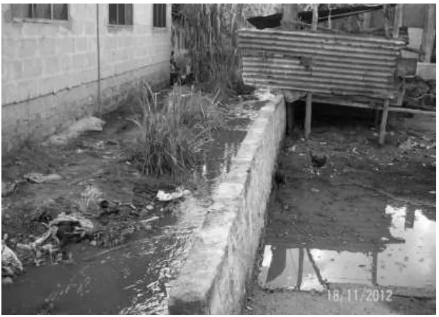
Livestock keeping
As a means of income sources diversification, other households engaged in livestock keeping, the types of livestock include pig, cow and chicken. On one side livestock keeping is beneficial to the people because it is a source of livelihood. However, environmentally it is a problem within the settlement. The wastes from the
animal sheds are thrown into a river stream and consequently cause health risks. One of the interviewed household who is close to a livestock keeper said that “it is common to feel unpleasant smell, and during rainfall the dung from livestock sheds get carried away by storm water and spread to various parts of the settlement
(see Figure 9).
This situation, in addition to spreading bad odors, increases flood associated risk because flood water gets mixed with wastes, animal dung and get transported into different area of the settlement.
Accessibility
Keko Machungwa is an informal settlement, it therefore has very few access roads and large part of the settlement is accessed by foot. Worse enough, the parts of the settlement which is within the valley and highly affected by floods no single road to be accessed by car. According to the response from households and sub ward leader, the area which is affected by floods is accessed through footpaths, whereby apart from being narrow they are also filled with water during rainy season (see Figure 10). During rainy season almost 75% of household in the settlement are forced to pass through waterlogged paths. Such paths normally contain human and animal excreta which are likely to cause health problems to the people.
Exposure to diseases
Generally, each of the factors explained above have negative impact to the residents. The situation is worsened by the increasing rainfall intensity. Different diseases were reported by interviewees and the quick assessment shows that the reported diseases (see Table 3) are either directly or indirectly flood related. Respondent’s exposure to different diseases was explored by asking the residents several diseases related questions. Responses to questions varied depending on the way different individuals have been affected. Diseases that were reported include: Malaria, Typhoid, fungus, Urinary tract infection, chlorella and rashes. Therefore if responsible authorities will not take immediate action to minimize flood impact, residents in Keko Machungwa will continue to suffer from similar flood related risks.
Table 3. Diseases affecting residents
CONCLUSION
It is true that floods as a result of climate changes have major consequences on human living environment, properties and livelihood activities. However, flooding associated risks in Keko Machungwa are exaggerated by absence of infrastructure services, failure of planning, poor coordination of development activities like house construction and low level of understanding of local people. This means that the Government should make sure that these issues are addressed in order to minimize flood related risks. Based on the foregoing discussion, the study recommendations are as follows;
In view of the impacts of climate change on informal settlements, settlement upgrading is the paramount importance. This can be done by providing basic services which include construction of canal/drainage channel alongside the river, provide clean water supply and construction of storm water drainage system in the different parts of the settlement. A good example can be taken from informal settlement upgrading project in Hanna Nassif. It has been reported that living conditions of the Hanna Nassif settlement have improved through an improved environment, with less flooding, decreased levels of diseases, greater access to social and economic services after upgrading project (Un-Habitat 2010). It is advised that Governments should therefore replicate the Hanna Nassif experience to Keko Machungwa and other informal settlements.
In tackling the critical problem of accessing clean and safe water, we should learn from the neighboring country (Kenya), the Government of Kenya introduces Standpipes in an informal settlement known as Kibera. This is also possible in Keko Machungwa, the government can establish standpipes in different parts of the settlement and avoid water connection by crossing the river which contain contaminated water.
Solid waste management system that was established need to be re-established by educating residents on the disadvantages of poor solid waste management as well as empowering the workers with facilities.
To ensure that residents get good cross ventilation of air within the settlement, authorities in collaboration with local leaders should inspect new buildings to ensure that they have provisions for adequate air ventilation.
Any intervention must involve local community. Community involvement is essential because: theyare the ones who understand opportunities and constraints within their local environment; they are the main beneficiary to any project related to minimizing flood impacts. The settlement has the advantage of having different actors and developers which are local people, NGOs, religious institution, local government and private developers. These include Ruby Roadways Company and Oil ComCompany. Therefore any plan to minimize flood related risks will succeed if all actors in the settlement are involved.
Ranked diseases Relation to climate
change Number of respondents Percentage of respondents
Malaria Indirect 30 40
Typhoid Direct 20 26.7
Fungus Direct 9 12
Urinary tract infection Indirect 7 9.3
Chlorella Direct 5 6.7
REFERENCES Integrated Disaster Management Strategy for Cities of Geo-Techno-Environmental Risks in North Africa. A case study of Algeria,
Integrated Disaster Risk
Management: Megacity
Vulnerability and Resilience,
Laxenburg (Austria), available at
www.iiasa.ac.at/Research/RMS/.../
benouar.pdf accessed 29th
February 2010.
Daze, A. Ambrose, K. and Ehrhart, C. (2009), Climate Vulnerability and
Capacity Analysis (1stedition),
available at
http://www.careclimatechange.org, accessed 23rd March 2012.
Hochrainer, S. (2006), Macroeconomic Risk Management Against Natural Disasters, Analysis Focused on Governments in Developing Countries, dissertation report,
Deutscher Universitats-Verlag.
Kolsky, P. (1999), Performance-based evaluation.of surface-water drainage for low income communities: a case study in Indore, Madhya Pradesh. Ph.D.
Thesis, University of London.
Lupala, J. (2002), Urban Types in Rapidly Vulnerability Assessment and Coping Mechanism Related to Floods in Urban Areas: A Community based case study in
Kampung Melayu, Indonesia, ITC thesis.
Munich, R. (2005), Topics Geo. Annual Review, Natural Catastrophes.
Nijland, H. J. (2005), Sustainable Development of Floodplains (SDF) Project, Journal of Environmental
Science and Policy (8) 245-252.
OECD. (2006), Competitive Cities in the
Global Economy, OECD, Paris.
OECD. (2011), Environmental Outlook to 2050, Climate Change Chapter, Pre-release version, OECD, Paris.
Parker, D. (1999), Flood, in Ingleton, J. (editor), Natural disaster
management. Leicester: Tudor
Rose, 38–40.
Rowlands, H. (2006), The Climate Challenge Game: How Might Computer Games be Used to Communicate the Issues of Climate Change?MSc Dissertation on
Environmental Change and
Management, Environmental
Change Institute, University of Oxford, accessed on 14 May 2012 Informal Residential Areas: The case of KekoMachungwa, Dar es Salaam, Tanzania, Jamba: Journal
of Disaster Risk Studies 4(1) 10
pages.
UNDP. (2004), Reducing Disaster Risk a
challenge for development, A
Un-Habitat (2010), Informal Settlements and Finance in Dar es Salaam,
Tanzania, Nairobi. Available at
www.unhabitat.org/pmss/getElectr onicVersion.aspx?nr=2935&al
accessed 11th August 2011.
Un-Habitat, (2010), Informal Settlements and Finance in Dar es Salaam,
Tanzania, Nairobi, available at
www.unhabitat.org/pmss/getElectr onicVersion.aspx?nr=2935&alt,
accessed 13 June 2012.
UN-Habitat. (2006), State of the World Cities 2006/2007 Report, Paper
presented at the Millennium
Developmet Goals and Urban
Sustainability: 30 years of shaping
the Habitat Agenda, Nairobi.
UN-Habitat. (2009), Planning for Sustainable Cities, Global Report
on Human Settlements, United
Nations Human Settlements Programme, Earthscan, London.
United Republic of Tanzania (2012), Strategic Cities Project.
United Republic of Tanzania, (2004), Dar es Salaam City profile by Dar es
Salaam city Council, accessed
![Figure 1. Settlements in unsafe areas [Marschiavelli, 2008 citing UNDP, 1992]](https://thumb-ap.123doks.com/thumbv2/123dok/854213.815551/2.595.71.524.397.582/figure-settlements-unsafe-areas-marschiavelli-citing-undp.webp)
![Figure 4. Keko Machungwa in Dar es Salaam City [URT, 2004]](https://thumb-ap.123doks.com/thumbv2/123dok/854213.815551/6.595.92.503.77.488/figure-keko-machungwa-in-dar-salaam-city-urt.webp)