SCIENCE & TECHNOLOGY
Journal homepage: http://www.pertanika.upm.edu.my/ISSN: 0128-7680 © 2017 Universiti Putra Malaysia Press.
ARTICLE INFO
Cililin Landslide Process Modelling Using
Lumped Mass Model
Duden Saepuzaman1*, Wahyu Srigutomo2 and Muhamad Gina Nugraha1 1Departemen Pendidikan Fisika, FPMIPA Universitas Pendidikan Indonesia,
Jl. Dr. Setiabudhi No.229, Bandung 40154, Indonesia
2Departemen Fisika FMIPA, Institut Teknologi Bandung, Jl. Ganesha No.10, Bandung 40132, Indonesia
ABSTRACT
This study analysed physical properties of landslides at Cililin using a Lumped Mass Model. It used analytical and numerical methods. The results show that landslide happens at a slope of about 32.74°
angle. It usually occurs at the base of the slope, around 700 m in the horizontal direction relative to
the initial position and the predicted landslides after landslides for 26 seconds. About 26 seconds after
the landslide, the run-out is 800 m with a total travel time of about 33 second. The length of the initial landslides is 200 m experienced as fragmentation effect until the base of the incline before it shrinks after passing basic tilt and stops at the end of 500 m length. The areas affected by the landslide are determined by analysing the centre of mass velocity and the front of the landslides. Prediction run-out for the three locations around the location of landslides Cililin, showed that the magnitude of the tangent slope angle is smaller than the value of the coefficient of friction, and hence it is not prone to landslides.
Keywords: Landslides, Landslide parameters, Lumped Mass Model
INTRODUCTION
Landslides, especially in the mountainous areas, are natural disasters that lead to loss of lives and properties. The mountainous
24 Pertanika J. Sci. & Technol. 25 (S): 23 - 34 (2017)
location of landslide is 6°59ʹ30,6780 ̋ SL and 107°28ʹ58,5756 ̋ EL precisely at the base of Mount Arca. This disaster left 17 people dead and at least seven homes were lost. Based on the landslide hazard map, the village Mukapayung was included in the high landslide danger zone. Some of the landslides in the area happened in 2001, 2009, and 2012. Looking at BNPB data, this means there are 124 million people in Indonesia who live in landslide prone areas. Landslides have major impacts that include loss of lives, injury, damage to building and infrastructure, disruption of services, loss of business and loss of confidence, loss of land resources, and environmental degradation (Chowdhury & Flentje, 2014).
Landslide can be defined as the movement of rock, debris or soil due to gravity (Blasio, 2011). In general, there are two factors that cause landslides, namely: 1) natural factors, such as rainfall, ground movement, soil and rocks, seismic and slope; 2) human activity, such as land development along steep hillsides and deforestation.
As mitigation, residents of Indonesia who occupy areas prone to landslides can be relocated to safer areas. But it is difficult to do because it involves many factors. Thus, the residents should be able to anticipate and protect themselves against landslides by anticipating heavy rains or preparing to seek a safe haven from the threat of landslides. They must also have the ability to build soil and water conservation, tree planting roots in long parallel contours, terraces, channels in the direction of the slope and so on. Many models describing the dynamics of landslides. Oremus’s (2006) model looks at the dynamics of landslide using a one-dimensional dense-snow landslide model (model of one-dimensional density snow landslide) by analysing the flow rate of the landslide to a safe distance prediction (run out). The modelling of landslide is very important to analyse its dynamics of landslide and hence, it is useful for prevention or mitigation of landslides. The information/ knowledge about of dynamics of landslide one effort to Landslide Risk Reduction (Winter, 2014).
De Blasio and Elverhoi (2008) proposed the model of rock landslide using a model of friction. The analysis includes the movement, speed and friction generated. Blasio (2011) used a lumped mass model (the other name for model of fixed mass) to describe cases of Elm landslide and landslide Novaya Zemlia. The analysis includes landslide velocity as a function of position, velocity and the mass centre of the front of the landslide as a function of position.
This paper describes the mechanism of Cililin landslide using Lumped Mass Model. This is a simple model to describe the dynamics of landslide and assumes the mass of landslide matter is constant. The lumped mass model successfully describes the stretching effect. It is the change of geometry (shape and size) of landslide matter.
Many studies have successfully described landslides. Generally, an analysis of motion landslides only focuses on the centre of mass motion. This research analysed the dynamics of landslide using centre of mass, front part of landslide matter, and stretching effect.
25 Pertanika J. Sci. & Technol. 25 (S): 23 - 34 (2017)
Landslide
In order to distinguish landslides with the flow / mass movement due to gravity, the former is defined as the largest part of the material that moves with a density of at least 10% greater than the density of water.
Gravity tends to drive the material to the slopes, if there is no cohesion and friction between rocks with soil. However, stable conditions may change due to the adjustment of balance or because of external interferences. In this case, landslides can be triggered by various factors. In general slope stability depends on several factors, including the type of material involved, the geometry of the material, the weight distribution along the slope, the water factor, the external impulsive force such as an earthquake, waves and volcanic eruptions, and vegetation (Blasio, 2011).
Lumped Mass Model
As a simple toy model, we can envisage a rock avalanche as a rigid, no deformable object moving down the slope and subject to the sole Coulomb friction. This avoids the difficult calculation of the internal deformations within the granular medium. In one type of model, called the lumped mass model, the whole mass is condensed to a single point. The equation of motion is calculated for this point, representative of the whole landslide. The centre of mass or the front of the landslide is a possible choice (Blasio, 2011).
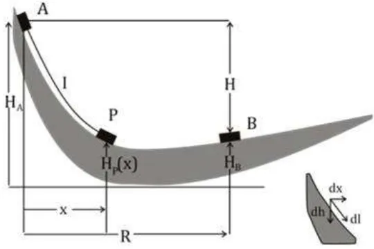
During a landslide, geometric changes, such as length, occur. The reason is that the landslide usually begins as a unit slab with very high cohesion. As it slides and strongly disintegrates, it is transformed into a deformable granular flow; the lateral pressure thus makes it to stretch, widening and flattening. While the centre of mass tends not to be affected by the fragmentation process, with the front can be widened in scope. The general condition is described in Figure 1.
)
(
x
∫
β
26 Pertanika J. Sci. & Technol. 25 (S): 23 - 34 (2017)
Figure 1 shows the basic geometric lumped mass model with some physics properties. If Hp (x) the height of the material is at a distance x, using the law of conservation of energy can be expressed as follows:
(1)
With β(x) local states as a function of tilt angle x and the kinetic energy. Integration in the above equation can be resolved as
(2)
So, they can get the equation for the value of speed as a function of x as the following
(3)
Using this equation will allow to calculate the speed at each point based on the height of the topography Hp (x). For cases with a straight line can be considered as a special case of this equation, the value Hp (x) can be determined using simple trigonometry. The coefficient of friction can also be determined using condition U(R) = 0, thus, providing value
(3)
With μ is coefficient of friction. In the same way, it can be analysed as a function of velocity values obtained value z axis
(4)
Values for each position will be useful at this time to determine the speed each time. The position of the data rate as a function of position can be determined numerically using MATLAB.
In explaining the landslide of material deformation, material landslide is no longer seen as an object but it is a point particle system continuously or only seen as a centre of mass movement only. For this purpose, the concept of the speed of the front (front velocity) landslide is proposed. Forward speed (front velocity) landslide is defined as:
(5)
With α = (1/2) (∆x/x1) a total stretching is defined as half of the total length change landslide
∆x = x2 - x1 compared to the initial length x1.
METHODS
27 Pertanika J. Sci. & Technol. 25 (S): 23 - 34 (2017)
landslide and surroundings. The trail (track) obtained from GPS and then transferred to Global Mapper. Output of Global Mapper form XYZ coordinates (XYZ Grid) which was then modelled into a surface location of the landslide in the study area Cililin. After the landslide surface model is obtained, projecting the surface to a field (e.g. field XZ) will be determined using slope and landslide. Cicilin Speed as a function of the position is determined using equation (2) and (4). As for determining the positions as a function of time is done numerically using MATLAB with input in the form velocity as a function of position, boundary conditions and initial conditions.
Determination of velocity as a function of time was performed by numerical differentiation method that includes five points. The dynamics of landslide is described using lumped mass model.
RESULTS AND DISCUSSIONS
Geometry Location Landslide
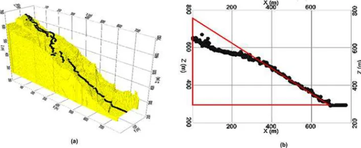
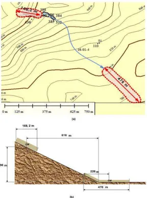
Based on data obtained at the site of landslide, the slope of the landslide area to the surface of the landslide is described as below.
Figure 2.(a) The trail surface landslide (b) slope of the projection into the field XZ
Figure 2 shows the geometric and slope around the surface and plane of landslide. This is from tracking GPS and using CRSP software. The landslide is first examined by analysing parts of the centre of mass. The coefficient of friction is determined by using the ratio of height of the run out.
In order to obtain
28 Pertanika J. Sci. & Technol. 25 (S): 23 - 34 (2017)
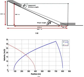
In general, for the first part of the track, the speed of moving landslide material is accelerated due to gravity. The speed value will continue to grow until the end of the slope that is when the horizontal distance equals to the distance x = R1. Speed at the end of the slope that
is at a distance of maximum value x = 700 m is the maximum Umaks (x) = 33 m / s. Velocity will be achieved at a distance x = 700 m with the speed value Umaks (x) = 33 m / s. As for the second path x > 700 m, the magnitude of the speed of the centre of mass can be calculated as below:
− −
− −
)
(x x
)
00
m
)
00
m
Figure 3. (a) The geometry of the surface of the landslide (b) The speed of the landslide as a function of position
Figure 3 shows the speed U(x) function of the horizontal distance x, landslide reaches a maximum at a horizontal distance R1(700 m) and then its speed decreases in flat track,
x > R1(700 m) because the influence of friction and it comes to a halt. The blue line describes
29 Pertanika J. Sci. & Technol. 25 (S): 23 - 34 (2017)
of the velocity U(x) is infinite good position on the starting position (x = 0) and the end position (x = 800 m) indicates the changes of speed significantly at both positions. So, by simple analysis on the position x = 800 m of a landslide suddenly stopped.
Position Centre of Massa Landslide Matter
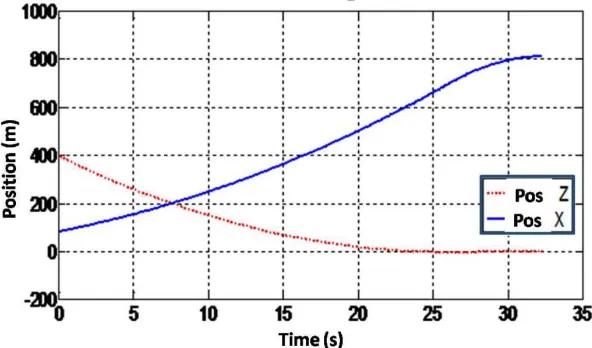
Positioning centre of mass landslide matter as a function of time is determined by using analytical methods. By using MATLAB, a position can be obtained at any time as follows.
Figure 4. Position centre of mass a function of time
Figure 4 shows that the speed reduction occurs in about a second. It is characterised by decrease of the slope of the graph x (t) and z (t) at that time (the slope of the graph position versus time is the speed). The initial position is not zero, because the reference position of landslide matter is centre of mass. From the graph, it also appears that the speed in the x direction is zero in and marked with a zero slope. This means the analysis is in accordance with the foregoing discussion that the avalanche of material stops after distance and time.
Long of Landslide Matter
Based on direct measurements at the site of the landslide, the length of the landslide was about 200 meters, while the thickness and width landslide, each about 11 meters and 55 meters, were determined by measuring the difference in the estimated coordinates of two point’s boundary part landslide.
30 Pertanika J. Sci. & Technol. 25 (S): 23 - 34 (2017)
Figure 5 shows the contour of Cililin landslide from initial position until the final position with the stretching effect. During landslide, there will stretching (stretching Securities) due to the effects of fragmentation and redistribution of material in the landslide in the area is quite large. Landslide forward speed (front velocity) will indicate a value greater than the speed of the centre of mass.
The areal landslide conditions shown in Figure 5 can be expressed as below:
31 Pertanika J. Sci. & Technol. 25 (S): 23 - 34 (2017)
The maximum speed is achieved at x = 700 m the moment with a value around 56 m / s. As for the second track, (x > 700 m)
This is shown in Figure 6.
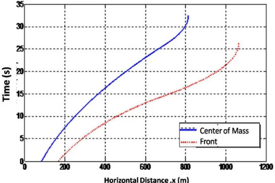
Figure 6.Graph of the speed of the centre of mass and the front of the landslide as a function of the horizontal
distance
32 Pertanika J. Sci. & Technol. 25 (S): 23 - 34 (2017)
Figure 7 shows the front of the landslide stops faster (t = 26,1 s) than the rest of the centre of mass (t = 32,2 s). This is the effect of the friction material field with landslide, thus, speeding up the pace of reduction in any part of the front of the landslide. The front of the landslide seemed to stop at x = 1063,7 m, for the centre of mass. 249.8 m difference is half of the length of the final landslide. Thus, it predicts the landslide end approximately 499.7 m. approaching the true value of 500 m. The general visualisation landslide mechanism for each time is shown in Figure 8.
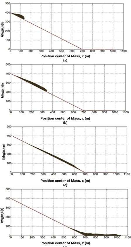
Figure 8. Visualisation landslide mechanism for each time (a) t = 0 s, (b) t = 7.6 s, (c) t = 14.8 and (d) t = 32.3 s
Position center of Mass, x (m) (a)
Position center of Mass, x (m) (b)
Position center of Mass, x (m) (c)
33 Pertanika J. Sci. & Technol. 25 (S): 23 - 34 (2017)
Figure 8 shows the visualisation landslide mechanism during the Cililin landslide. The geometric landslide matter changes during the flow, such as length and shape.
CONCLUSIONS
The Cililin landslide can be describe using Lumped Mass Model. Based on Lumped Mass Model the velocity of landslide matter at initial condition is 12 m/s in horizontal direction (x-axis) and 30 m/s in vertical direction (y-axis). There are geometric landslide changes during the flow, such as length as the stretching effect. The initial length changes from 200 m (initial length) to 500 m (final length in the final condition, where the landslide matter stopped or the speed is zero).
REFERENCES
Badan Nasional Penanggulangan Bencana (BNPB). (2013). Rencana kontinjensi nasional menghadapi ancaman bencana asap akibat kebakaran hutan dan lahan. Jakarta (ID).
Chowdhury, R., & Flentje, P. (2014). Mitigation of landslide impacts, strategies and challenges for the 21st century.
De Blasio, F. V., & Elverhøi, A. (2008). A model for frictional melt production beneath large rock avalanches. Journal of Geophysical Research: Earth Surface, 113(F2).
Delaney, K. B., & Evans, S. G. (2014). The 1997 Mount Munday landslide (British Columbia) and the behaviour of rock avalanches on glacier surfaces. Landslides, 11(6), 1019-1036.
Oremus, R. M. (2006). A one-dimensional model of dense snow avalanches using mass and momentum balances (Doctoral dissertation, Humboldt State University).
Sumantra, S. B., & Raghunath, P. (2016). Causes of Landslides in Darjeeling Himalayas during June-July, 2015. J Geogr Nat Disast, 6(173), 2167-0587.