Open Geospatial Consortium
Approval Date: 2011-12-12
Publication Date: 2013-09-17
External OGC identifier: http://www.opengis.net/doc/is/om/2.0
Reference number of this document:OGC 10-004r3
Version:2.0
Category: OGC® Standard: Abstract Specification
Editors: Simon Cox
OGC Abstract Specification
Geographic information — Observations and measurements
Copyright © 2013 Open Geospatial Consortium
To obtain additional rights of use, visit http://www.opengeospatial.org/legal/.
Warning
This document is an OGC Member approved international standard. This document is available on a royalty free, non-discriminatory basis. Recipients of this document are invited to submit, with their comments, notification of any relevant patent rights of which they are aware and to provide supporting documentation. This standard was jointly developed between the OGC and ISO TC 211 and is double branded.
Document type:
OGC® Abstract SpecificationDocument subtype:
EncodingISO TC 211/SC
ISO 19156:2011(E)
Secretariat: SN
First edition
2011-12-15
Geographic information — Observations and measurements
Information géographique — Observations et mesures
License Agreement
Permission is hereby granted by the Open Geospatial Consortium, ("Licensor"), free of charge and subject to the terms set forth below, to any person obtaining a copy of this Intellectual Property and any associated documentation, to deal in the Intellectual Property without restriction (except as set forth below), including without limitation the rights to implement, use, copy, modify, merge, publish, distribute, and/or sublicense copies of the Intellectual Property, and to permit persons to whom the Intellectual Property is furnished to do so, provided that all copyright notices on the intellectual property are retained intact and that each person to whom the Intellectual Property is furnished agrees to the terms of this Agreement.
If you modify the Intellectual Property, all copies of the modified Intellectual Property must include, in addition to the above copyright notice, a notice that the Intellectual Property includes modifications that have not been approved or adopted by LICENSOR.
THIS LICENSE IS A COPYRIGHT LICENSE ONLY, AND DOES NOT CONVEY ANY RIGHTS UNDER ANY PATENTS THAT MAY BE IN FORCE ANYWHERE IN THE WORLD.
THE INTELLECTUAL PROPERTY IS PROVIDED "AS IS", WITHOUT WARRANTY OF ANY KIND, EXPRESS OR IMPLIED, INCLUDING BUT NOT LIMITED TO THE WARRANTIES OF MERCHANTABILITY, FITNESS FOR A PARTICULAR PURPOSE, AND NONINFRINGEMENT OF THIRD PARTY RIGHTS. THE COPYRIGHT HOLDER OR HOLDERS INCLUDED IN THIS NOTICE DO NOT WARRANT THAT THE FUNCTIONS CONTAINED IN THE INTELLECTUAL PROPERTY WILL MEET YOUR REQUIREMENTS OR THAT THE OPERATION OF THE INTELLECTUAL PROPERTY WILL BE UNINTERRUPTED OR ERROR FREE. ANY USE OF THE INTELLECTUAL PROPERTY SHALL BE MADE ENTIRELY AT THE USER’S OWN RISK. IN NO EVENT SHALL THE COPYRIGHT HOLDER OR ANY CONTRIBUTOR OF INTELLECTUAL PROPERTY RIGHTS TO THE INTELLECTUAL PROPERTY BE LIABLE FOR ANY CLAIM, OR ANY DIRECT, SPECIAL, INDIRECT OR CONSEQUENTIAL DAMAGES, OR ANY DAMAGES WHATSOEVER RESULTING FROM ANY ALLEGED INFRINGEMENT OR ANY LOSS OF USE, DATA OR PROFITS, WHETHER IN AN ACTION OF CONTRACT, NEGLIGENCE OR UNDER ANY OTHER LEGAL THEORY, ARISING OUT OF OR IN CONNECTION WITH THE IMPLEMENTATION, USE, COMMERCIALIZATION OR PERFORMANCE OF THIS INTELLECTUAL PROPERTY.
This license is effective until terminated. You may terminate it at any time by destroying the Intellectual Property together with all copies in any form. The license will also terminate if you fail to comply with any term or condition of this Agreement. Except as provided in the following sentence, no such termination of this license shall require the termination of any third party end-user sublicense to the Intellectual Property which is in force as of the date of notice of such termination. In addition, should the Intellectual Property, or the operation of the Intellectual Property, infringe, or in LICENSOR’s sole opinion be likely to infringe, any patent, copyright, trademark or other right of a third party, you agree that LICENSOR, in its sole discretion, may terminate this license without any compensation or liability to you, your licensees or any other party. You agree upon termination of any kind to destroy or cause to be destroyed the Intellectual Property together with all copies in any form, whether held by you or by any third party.
Contents
Page2.2
Conformance classes related to Application Schemas including Observations and Measurements ... 2
3
Normative references ... 2
4
Terms and definitions ... 3
5
Abbreviated terms and notation ... 5
5.1
Abbreviated terms ... 5
5.2
Schema language ... 6
5.3
Model element names ... 6
6
Dependencies ... 6
7
Fundamental characteristics of observations ... 7
7.1
The context for observations ... 7
7.2
Observation schema ... 8
7.3
Use of the observation model ... 15
8
Specialized observations ... 15
8.1
Classification of observation by result type ... 15
8.2
Observations whose result is constant ... 16
8.3
Observations whose result varies ... 17
9
Fundamental characteristics of sampling features ... 19
9.1
The context for sampling ... 19
9.2
Sampling Schema ... 20
10
Spatial sampling features ... 24
10.1
The context for spatial sampling features ... 24
10.2
Spatial sampling feature schema ... 24
10.3
Decomposition of extensive sampling features for observations ... 26
10.4
Common names for sampling features (informative) ... 26
11
Specimens ... 27
11.1
The context for specimens ... 27
11.2
Specimen schema ... 27
Annex A (normative) Abstract Test Suite ... 30
Annex B (informative) Mapping O&M terminology to common usage ... 35
Annex C (normative) Utility classes ... 38
Annex D (informative) Best practices in use of the observation and sampling models ... 40
Foreword
ISO (the International Organization for Standardization) is a worldwide federation of national standards bodies (ISO member bodies). The work of preparing International Standards is normally carried out through ISO technical committees. Each member body interested in a subject for which a technical committee has been established has the right to be represented on that committee. International organizations, governmental and non-governmental, in liaison with ISO, also take part in the work. ISO collaborates closely with the International Electrotechnical Commission (IEC) on all matters of electrotechnical standardization.
International Standards are drafted in accordance with the rules given in the ISO/IEC Directives, Part 2. The main task of technical committees is to prepare International Standards. Draft International Standards adopted by the technical committees are circulated to the member bodies for voting. Publication as an International Standard requires approval by at least 75 % of the member bodies casting a vote.
Attention is drawn to the possibility that some of the elements of this document may be the subject of patent rights. ISO shall not be held responsible for identifying any or all such patent rights.
Introduction
This International Standard arises from work originally undertaken through the Open Geospatial Consortium’s Sensor Web Enablement (SWE) activity. SWE is concerned with establishing interfaces and protocols that will enable a “Sensor Web” through which applications and services will be able to access sensors of all types, and observations generated by them, over the Web. SWE has defined, prototyped and tested several components needed for a Sensor Web, namely:
— Sensor Model Language (SensorML).
— Observations & Measurements (O&M).
— Sensor Observation Service (SOS).
— Sensor Planning Service (SPS).
— Sensor Alert Service (SAS).
This International Standard specifies the Observations and Measurements schema, including a schema for sampling features.
The content presented here derives from an earlier version published by Open Geospatial Consortium as OGC 07-022r1, Observations and Measurements — Part 1 — Observation schema and OGC 07-002r3,
Observations and Measurements — Part 2 — Sampling Features. A technical note describing the changes
from the earlier version is available from the Open Geospatial Consortium (see
Geographic information — Observations and measurements
Geographic information — Observations and measurements
1 Scope
This International Standard defines a conceptual schema for observations, and for features involved in sampling when making observations. These provide models for the exchange of information describing observation acts and their results, both within and between different scientific and technical communities.
Observations commonly involve sampling of an ultimate feature-of-interest. This International Standard defines a common set of sampling feature types classified primarily by topological dimension, as well as samples for ex-situ observations. The schema includes relationships between sampling features (sub-sampling, derived samples).
This International Standard concerns only externally visible interfaces and places no restriction on the underlying implementations other than what is needed to satisfy the interface specifications in the actual situation.
2 Conformance
2.1 Overview
Clauses 7 to 11 of this International Standard use the Unified Modeling Language (UML) to present conceptual schemas for describing Observations. These schemas define conceptual classes that
a) may be considered to comprise a cross-domain application schema, or
b) may be used in application schemas, profiles and implementation specifications.
This flexibility is controlled by a set of UML types that can be implemented in a variety of manners. Use of alternative names that are more familiar in a particular application is acceptable, provided that there is a one-to-one mapping to classes and properties in this International Standard.
The UML model in this International Standard defines conceptual classes; various software systems define implementation classes or data structures. All of these reference the same information content. The same name may be used in implementations as in the model, so that types defined in the UML model may be used directly in application schemas.
2.2 Conformance classes related to Application Schemas including Observations and
Measurements
The conformance rules for Application Schemas in general are described in ISO 19109:2005. Application Schemas also claiming conformance to this International Standard shall also conform to the rules specified in Clauses 7 to 11 and pass all relevant test cases of the Abstract Test Suite in Annex A.
Depending on the characteristics of an Application Schema, 18 conformance classes are distinguished. Table 1 lists these classes and the corresponding subclause of the Abstract Test Suite.
Table 1 — Conformance classes related to Application Schemas including Observations and Measurements
Conformance class Subclause
Generic observation interchange A.1.1
Measurement interchange A.1.1, A.1.2
Category observation interchange A.1.1, A.1.3
Count observation interchange A.1.1, A.1.4
Truth observation interchange A.1.1, A.1.5
Temporal observation interchange A.1.1, A.1.6
Geometry observation interchange A.1.1, A.1.7
Complex observation interchange A.1.1, A.1.8
Discrete coverage observation interchange A.1.1, A.1.9
Point coverage observation interchange A.1.1, A.1.10
Time series observation interchange A.1.1, A.1.11
Sampling feature interchange A.2.1, A.2.2
Spatial sampling feature interchange A.2.1 to A.2.3
Sampling point interchange A.2.1 to A.2.4
Sampling curve interchange A.2.1 to A.2.3, A.2.5
Sampling surface interchange A.2.1 to A.2.3, A.2.6
Sampling solid interchange A.2.1 to A.2.3, A.2.7
Specimen interchange A.2.1 to A.2.3, A.2.8
3 Normative references
The following referenced documents are indispensable for the application of this document. For dated references, only the edition cited applies. For undated references, the latest edition of the referenced document (including any amendments) applies.
ISO 19101:2002, Geographic information — Reference model
ISO/TS 19103:2005, Geographic information — Conceptual schema language
ISO 19107:2003, Geographic information — Spatial schema
ISO 19108:2002, Geographic information — Temporal schema
ISO 19111:2007, Geographic information — Spatial referencing by coordinates
ISO 19115:2003, Geographic information — Metadata
ISO 19115:2003/Cor.1:2006, Geographic information — Metadata — Technical Corrigendum 1
ISO 19123:2005, Geographic information — Schema for coverage geometry and functions
ISO 19136:2007, Geographic information — Geography Markup Language (GML)
ISO/IEC 19501:2005, Information technology — Open Distributed Processing — Unified Modeling Language (UML) Version 1.4.2
ISO 19157:—1, Geographic information — Data quality
4 Terms and definitions
For the purposes of this document, the following terms and definitions apply.
4.1
application schema
conceptual schema for data required by one or more applications
[ISO 19101:2002, definition 4.2]
4.2 coverage
feature that acts as a function to return values from its range for any direct position within its spatial, temporal or spatiotemporal domain
[ISO 19123:2005, definition 4.17]
4.3 data type
specification of a value domain with operations allowed on values in this domain
[ISO/TS 19103:2005, definition 4.1.5]
EXAMPLE Integer, Real, Boolean, String, Date (conversion of a date into a series of codes).
NOTE Data types include primitive predefined types and user-definable types. All instances of a data type lack identity.
4.4
domain feature
feature of a type defined within a particular application domain
NOTE This may be contrasted with observations and sampling features, which are features of types defined for cross-domain purposes.
4.5 ex-situ
referring to the study, maintenance or conservation of a specimen or population away from its natural surroundings
NOTE Opposite of in-situ.
4.6 feature
abstraction of real-world phenomena
[ISO 19101:2002, definition 4.11]
NOTE A feature may occur as a type or an instance. In this International Standard, feature instance is meant unless otherwise specified.
4.7
feature type
class of features having common characteristics
4.8
measurand
particular quantity subject to measurement
[ISO/TS 19138:2006, definition 4.5]
NOTE Specialization of observable property type.
4.9 measure
value described using a numeric amount with a scale or using a scalar reference system
[ISO 19136:2007, definition 4.1.41]
4.10
measurement
set of operations having the object of determining the value of a quantity
[ISO/TS 19101-2:2008, definition 4.20]
4.11
observation
act of measuring or otherwise determining the value of a property
4.12
observation procedure
method, algorithm or instrument, or system of these, which may be used in making an observation
4.13
observation protocol
combination of a sampling strategy and an observation procedure used in making an observation
4.14
observation result
estimate of the value of a property determined through a known observation procedure
4.15 property
facet or attribute of an object referenced by a name
[ISO 19143:2010, definition 4.21]
4.16
property type
characteristic of a feature type
EXAMPLE Cars (a feature type) all have a characteristic colour, where "colour" is a property type.
NOTE 1 The value for an instance of an observable property type can be estimated through an act of observation.
NOTE 2 In chemistry-related applications, the term "determinand" or "analyte" is often used.
NOTE 3 Adapted from ISO 19109:2005.
4.17
sampling feature
feature which is involved in making observations concerning a domain feature
EXAMPLE Station, transect, section or specimen.
NOTE A sampling feature is an artefact of the observational strategy, and has no significance independent of the observational campaign.
4.18 value
element of a type domain
[ISO/IEC 19501:2005]
NOTE 1 A value considers a possible state of an object within a class or type (domain).
NOTE 2 A data value is an instance of a datatype, a value without identity.
NOTE 3 A value can use one of a variety of scales including nominal, ordinal, ratio and interval, spatial and temporal. Primitive datatypes can be combined to form aggregate datatypes with aggregate values, including vectors, tensors and images.
5 Abbreviated terms and notation
5.1 Abbreviated terms
GFM General Feature Model
GML Geography Markup Language
O&M Observations and Measurements
OGC Open Geospatial Consortium
SensorML Sensor Model Language
SOS Sensor Observation Service
SWE Sensor Web Enablement
XML Extensible Markup Language
1-D One Dimensional
2-D Two Dimensional
3-D Three Dimensional
5.2 Schema language
The conceptual schema specified in this International Standard is in accordance with the Unified Modelling Language (UML) ISO/IEC 19501, following the guidance of ISO/TS 19103.
The UML is conformant with the profile described in ISO 19136:2007, Annex E. Use of this restricted idiom supports direct transformation into a GML Application Schema. ISO 19136 introduces some additional stereotypes. In particular «FeatureType» implies that a class is an instance of the «metaclass» GF_FeatureType (ISO 19109), and therefore represents a feature type.
The prose explanation of the model uses the term “property” to refer to both class attributes and association roles. This is consistent with the General Feature Model described in ISO 19109. In the context of properties, the term “value” refers to either a literal (for attributes whose type is simple), or to an instance of the class providing the type of the attribute or target of the association. Within the explanation, the property names (property types) are sometimes used as natural language words where this assists in constructing a readable text.
5.3 Model element names
This International Standard specifies a model for observations using terminology that is based on current practice in a variety of scientific and technical disciplines. It is designed to apply across disciplines, so the best or "most neutral" term has been used in naming the classes, attributes and associations provided. The terminology does not, however, correspond precisely with any single discipline. As an aid to implementors, a mapping from the element names specified in this International Standard to common terminology in some application domains is provided in Annex B.
6 Dependencies
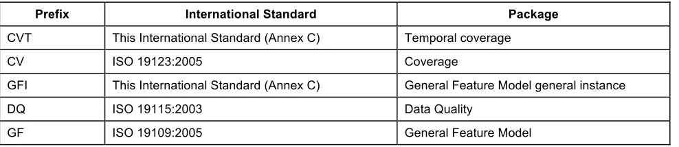
Some model elements used in the schema described in Clauses 7 to 11 are defined in other International Standards. By convention within ISO/TC 211, names of UML classes, with the exception of basic data type classes, include a two or three letter prefix that identifies the International Standard and the UML package in which the class is defined. Table 2 lists the standards and packages in which UML classes used in this International Standard have been defined. UML classes defined in this International Standard have the prefix of CVT, GFI, OM and SF. The prefix GFI is used for classes defined in this International Standard, but which are associated with the GF package in ISO 19109. The prefix CVT is used for classes defined in this International Standard, but which are associated with the CV package in ISO 19123:2005.
Table 2 — Sources of UML classes
Prefix International Standard Package
CVT This International Standard (Annex C) Temporal coverage
CV ISO 19123:2005 Coverage
GFI This International Standard (Annex C) General Feature Model general instance
DQ ISO 19115:2003 Data Quality
Prefix International Standard Package
GM ISO 19107:2003 Geometry
LI ISO 19115:2003, ISO 19115:2003/Cor.1:2006 Data Quality
MD ISO 19115:2003/Cor.1:2006 Metadata Entity
OM This International Standard Observations and Measurements
SC ISO 19111:2007 Coordinate reference systems
SF This International Standard Sampling features
TM ISO 19108:2002 Temporal Schema
7 Fundamental characteristics of observations
7.1 The context for observations
7.1.1 Property evaluation
Properties of a feature fall into two basic categories:
a) Value (e.g. name, price, legal boundary) assigned by some authority. These are exact.
b) Value (e.g. height, classification, colour) determined by application of an observation procedure. These are estimates, with a finite error associated with the value.
The observation error typically has a systematic component, which is similar for all estimates made using the same procedure, and a random component, associated with the particular application instance of the observation procedure. If potential errors in a property value are important in the context of a data analysis or processing application, then the details of the act of observation which provided the estimate of the value are required.
7.1.2 Observation
An observation is an act associated with a discrete time instant or period through which a number, term or other symbol is assigned to a phenomenon [2]. It involves application of a specified procedure, such as a sensor, instrument, algorithm or process chain. The procedure may be applied in-situ, remotely, or ex-situ with respect to the sampling location. The result of an observation is an estimate of the value of a property of some feature. Use of a common model allows observation data using different procedures to be combined unambiguously.
The observation itself is also a feature, since it has properties and identity.
Observation details are important for data discovery and for data quality estimation.
The observation could be considered to carry “property-level” instance metadata, which complements the dataset-level and feature-level metadata that have been conventionally considered (e.g. ISO 19115).
NOTE ISO 19115-2:2009 provides MI_Event, which plays a similar role to OM_Observation in the context of image capture.
7.1.3 Observation properties
or simulator. The key idea is that the observation result is an estimate of the value of some property of the feature-of-interest, and the other observation properties provide context or metadata to support evaluation, interpretation and use of the result.
The relationship between the properties of an observation and those of its feature-of-interest is key to the semantics of the model. This is further elaborated in D.3.
7.1.4 Observation location
The principal location of interest is usually associated with the ultimate feature-of-interest.
However, the location of the feature-of-interest may not be trivially available. For example: in remote sensing applications, a complex processing chain is required to geolocate the scene or swath; in feature-detection applications the initial observation may be made on a scene, but the entity to be detected, which is the ultimate feature-of-interest, occupies some location within it. The distinction between the proximate and ultimate feature-of-interest is a key consideration in these cases.
Other locations appear in various scenarios. Sub-sampling at locations within the feature-of-interest may occur. The procedure may involve a sensor located remotely from the ultimate feature-of-interest (e.g. remote sensing; or where specimens are removed from their sampling location and observations made ex-situ). Furthermore, the location of the feature-of-interest may be time-dependent.
The model is generic. The geospatial location of the feature-of-interest may be of little or no interest for some observations (e.g. live specimens, observations made on non-located things like chemical species).
For these reasons, a generic Observation class does not have an inherent location property. Relevant location information should be provided by the feature-of-interest, or by the observation procedure, according to the specific scenario.
NOTE In contrast to spatial properties, some temporal properties are associated directly with an observation (7.2.2.2; 7.2.2.3). This is a consequence of the fact that an observation is a kind of ‘event’ so its temporal characteristics are fundamental, rather than incidental.
7.1.5 Result types
Observation results may have many datatypes, including primitive types like category or measure, but also more complex types such as time, location and geometry. Complex results are obtained when the observed property requires multiple components for its encoding. Furthermore, if the property varies on the feature-of-interest, then the result is a coverage, whose domain extent is the extent of the feature. In a physical realization, the result will typically be sampled discretely on the domain, and may be represented as a discrete coverage.
The result type may be used as a basis for defining specialized observation types.
7.1.6 Measurements
In conventional measurement theory (e.g. [1][5][10][11][19]) the term “measurement” is used. However, a distinction between measurement and category-observation has been adopted in more recent work [2][12][21] so the term “observation” is used here for the general concept. “Measurement” may be reserved for cases where the result is a numerical quantity.
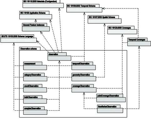
7.2 Observation schema
7.2.1 Packaging
Standards covering geographic information, on the General Feature Instance package (C.2) and the Temporal Coverage package (C.3). The inter-package dependencies are shown in Figure 1. The core observation package is documented in this subclause. The specialized observations are documented in Clause 8.
Figure 1 — Package dependencies of the observation schema
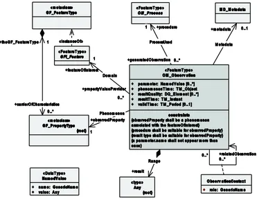
7.2.2 OM_Observation
7.2.2.1 General
Figure 2 — The basic Observation type
7.2.2.2 phenomenonTime
The attribute phenomenonTime:TM_Object shall describe the time that the result (7.2.2.9) applies to the property of the feature-of-interest (7.2.2.7). This is often the time of interaction by a sampling procedure (9.1.3) or observation procedure (7.2.2.10) with a real-world feature.
NOTE The phenomenonTime is the temporal parameter normally used in geospatial analysis of the result.
If the observedProperty of an observation is ‘occurrence time’ then the result should be the same as the phenomenonTime.
7.2.2.3 resultTime
The attribute resultTime:TM_Instant shall describe the time when the result became available, typically when the procedure (7.2.2.10) associated with the observation was completed. For some observations, this is identical to the phenomenonTime. However, there are important cases where they differ.
EXAMPLE 1 Where a measurement is made on a specimen in a laboratory, the phenomenonTime is the time the specimen was retrieved from its host, while the resultTime is the time the laboratory procedure was applied.
EXAMPLE 2 The resultTime also supports disambiguation of repeat measurements made of the same property of a feature using the same procedure.
EXAMPLE 3 Where sensor observation results are post-processed, the resultTime is the post-processing time, while the phenomenonTime is the time of initial interaction with the world.
7.2.2.4 validTime
If present, the attribute validTime:TM_Period shall describe the time period during which the result is intended to be used.
NOTE This attribute is commonly required in forecasting applications.
7.2.2.5 parameter
If present, the attributes parameter:NamedValue shall describe an arbitrary event-specific parameter. This might be an environmental parameter, an instrument setting or input, or an event-specific sampling parameter that is not tightly bound to either the feature-of-interest (7.2.2.7) or to the observation procedure (7.2.2.10). To avoid ambiguity, there shall be no more than one parameter with the same name.
NOTE Parameters that are tightly bound to the procedure can be recorded as part of the procedure description.
In some contexts, the Observation::procedure (7.2.2.10) is a generic or standard procedure, rather than an event-specific process. In this context, parameters bound to the observation act, such as instrument settings, calibrations or inputs, local position, detection limits, asset identifier, operator, may augment the description of a standard procedure.
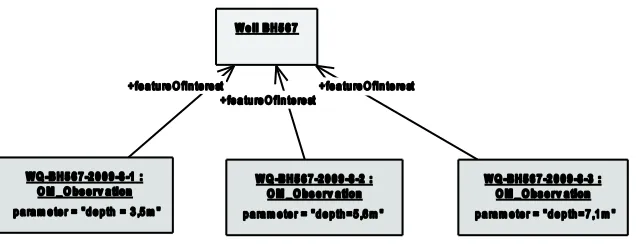
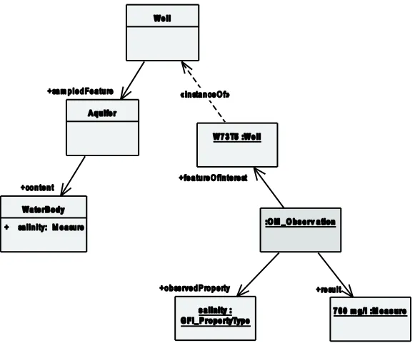
EXAMPLE A time sequence of observations of water quality in a well might be made at variable depths within the well. While these can be associated with specimens taken from the well at this depth as the features-of-interest, a more common approach is to identify the well itself as the feature-of-interest, and add a “samplingDepth” parameter to the observation (Figure 3). The sampling depth is of secondary interest compared to the temporal variation of water quality at the site.
Figure 3 — (Example) Observation instances in the same well at different depths, described using the ‘parameter’ attribute
7.2.2.6 resultQuality
If present, the attributes resultQuality:DQ_Element shall describe the quality of the result (7.2.2.9). This instance-specific description complements the description of the observation procedure (7.2.2.10), which provides information concerning the quality of all observations using this procedure. The quality of a result may be assessed following the procedures in ISO 19157. Multiple measures may be provided.
7.2.2.7 Domain
7.2.2.8 Phenomenon
The association Phenomenon shall link the OM_Observation to the GF_PropertyType for which the OM_Observation:result (7.2.2.9) provides an estimate of its value. The property type has the role
observedProperty with respect to the observation.
The observed property shall be a phenomenon associated with the feature-of-interest.
An observed property may be, but need not be, modelled as a property (in the sense of the General Feature Model) in a formal application schema that defines the type of the feature-of-interest.
An instance of GF_PropertyType shall describe a property that is either assignable or observable (7.1.2), such as "temperature", "height", "colour", "material". A property type may be an operation or function such as a spatiotemporal coverage. Property-type definitions may be organized into a hierarchy or ontology and managed in a register and catalogued to support discovery functions. The observed property supports semantic or thematic classification of observations, which is useful for discovery and data fusion.
NOTE In general, the value of a specific observedProperty can be associated with different feature types in different observations, thus allowing the results of observations made in different projects or campaigns, and even from different disciplines, to be combined when required. A property-type register used in observations is most useful if each property type is not tied to a single feature type, or if equivalence relationships between similar property types from different feature types are provided.
7.2.2.9 Range
The association Range shall link the OM_Observation to the value generated by the procedure. The value has the role result with respect to the observation. The type of the result is shown as “Any”, since it may represent the value of any feature property.
NOTE 1 OGC SWE Common [20] provides a model suitable for describing many kinds of observation results.
The type of the observation result shall be consistent with the observed property, and the scale or scope for the value shall be consistent with the quantity or category type. If the observed property (7.2.2.8) is a spatial operation or function, the type of the result may be a coverage.
NOTE 2 In some contexts, particularly in earth and environmental sciences, the term “observation” is used to refer to the result itself.
7.2.2.10 ProcessUsed
The association ProcessUsed shall link the OM_Observation to the OM_Process (7.2.3) used to generate the result. The process has the role procedure with respect to the observation. A process might be responsible for more than one generatedObservation.
The OM_Process shall be suitable for the observed property. As a corollary, details of the observed property are constrained by the procedure used.
EXAMPLE Observed radiance wavelength is determined by the response characteristics of the sensor.
A description of the observation procedure provides or implies an indication of the reliability or quality of the observation result.
7.2.2.11 Metadata
7.2.2.12 Constraints — Consistency with domain model
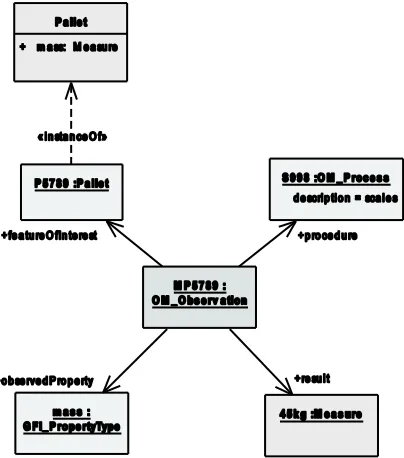
The type of the feature-of-interest is defined in an application schema (ISO 19109). This may be part of a domain model, or may be from a cross-domain model, such as Sampling Features (Clause 9). The feature type defines its set of properties. For consistency, the feature-of-interest shall carry the observed property as part of the definition of its type (e.g. Figure 4).
EXAMPLE A feature type “Pallet” might be defined as having the attribute “mass” of type “Measure”. An observation providing the value of this property shall have observedProperty=“mass”, the result shall be of the type “Measure” and the scale (unit of measure) shall be suitable for mass measurements.
Figure 4 — (Example) An observation with consistent properties: the observed property (mass) is a phenomenon associated with the type of the feature-of-interest (Pallet) and the procedure
and result type are also suitable
Figure 5 — (Example) An observation where the observed property is not a direct member of the type of the feature-of-interest
Other consistency constraints are that
— the procedure shall be suitable for the observed property, and
— the result type shall be consistent with the observed property (e.g. Figure 4).
7.2.3 OM_Process
The class OM_Process (Figure 2) is an instance of the «metaclass» GF_FeatureType (ISO 19109), which therefore represents a feature type. OM_Process is abstract, and has no attributes, operations or associations. It serves as the base class for observation processes. The purpose of an observation process is to generate an observation result. An instance of OM_Process is often an instrument or sensor, but may be a human observer, a simulator, or a process or algorithm applied to more primitive results used as inputs.
NOTE ISO 19115-2 provides MI_Instrument, LE_Processing and LE_Algorithm, which could all be modelled as specializations of OM_Process. OGC SensorML [16] provides a model which is suitable for many observation procedures.
7.2.4 ObservationContext
7.2.4.1 General
Some observations depend on other observations to provide a context which is important, sometimes essential, in understanding the result. These dependencies are stronger than mere spatiotemporal coincidences, requiring explicit representation. If present, the association class ObservationContext (Figure 2) shall link an OM_Observation to another OM_Observation, with the role name relatedObservation for the target. It shall support one attribute.
This association complements the Intention association (9.2.2.1, 9.2.2.4) which describes relationships between a sampling feature and domain features.
7.2.4.2 role
The attribute role:GenericName shall describe the relationship of the target OM_Observation to the source OM_Observation.
7.2.5 NamedValue
7.2.5.1 General
The class NamedValue provides for a generic soft-typed parameter value. NamedValue shall support two attributes.
7.2.5.2 name
The attribute name:GenericName shall indicate the meaning of the named value. Its value should be taken from a well-governed source if possible.
EXAMPLE When used as the value of an Observation:;parameter, the name might take values like ‘procedureOperator’, ‘detectionLimit’, ‘amplifierGain’, ‘samplingDepth’.
7.2.5.3 value
The attribute value:Any shall provide the value. The type “Any” should be substituted by a suitable concrete type, such as CI_ResponsibleParty or Measure.
7.3 Use of the observation model
The Observation model takes a data-user-centric viewpoint, emphasizing the semantics of the feature-of-interest and its properties. This contrasts with Sensor-oriented models, which take a process- and thus provider-centric viewpoint.
An observation is a property-value-provider for a feature-of-interest. Aside from the result, the details of the observation event are primarily of interest in applications where an evaluation of errors in the estimate of the value of a property is of concern. The Observation could be considered to carry “property-level” instance metadata, complementing the dataset-level and feature-level metadata that have been conventionally considered (e.g. ISO 19115).
Additional discussion of the application of the observation and sampling models, and nuances within these, is provided in Annex D.
8 Specialized observations
8.1 Classification of observation by result type
The observation result type shall be suitable for the observed property. The observation type may be classified by the type of the result. Two groups of specialized observations may be distinguished:
b) Observations whose result varies within the scope of the feature-of-interest: observations for which the result of a single observation contains multiple values that vary with either spatial position, time, or both, during the duration of the observation.
8.2 Observations whose result is constant
8.2.1 General
Where a property of the feature-of-interest is spatially and temporally invariant during the period of an observation, the corresponding observation result is a scalar (e.g. mass, length, temperature), or a record whose components correspond to a thematic decomposition of the observed property (e.g. bands of a spectrum, components of a wind-velocity vector, components of a stress tensor, elements of a geometry). Where a standard model for the observed property is available, this may be used for the result (e.g. observations of position, shape, or time should use GM_Object and TM_Object).
8.2.2 Taxonomy of observation types whose result is constant
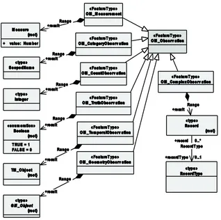
Observation types with results that are internally invariant with respect to space or time are in the Specialized Observation package and are shown in Figure 6.
Figure 6 — Specializations of observation by result type
The classes Measure, ScopedName, Integer, Boolean, Record and RecordType are defined in ISO/TS 19103, TM_Object in ISO 19108 and GM_Object in ISO 19107.
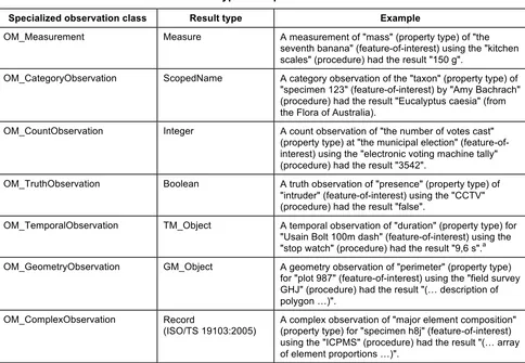
Table 3 — Result types for specialized observations
Specialized observation class Result type Example
OM_Measurement Measure A measurement of "mass" (property type) of "the seventh banana" (feature-of-interest) using the "kitchen scales" (procedure) had the result "150 g".
OM_CategoryObservation ScopedName A category observation of the "taxon" (property type) of "specimen 123" (feature-of-interest) by "Amy Bachrach" (procedure) had the result "Eucalyptus caesia" (from the Flora of Australia).
OM_CountObservation Integer A count observation of "the number of votes cast" (property type) at "the municipal election" (feature-of-interest) using the "electronic voting machine tally" (procedure) had the result "3542".
OM_TruthObservation Boolean A truth observation of "presence" (property type) of "intruder" (feature-of-interest) using the "CCTV" (procedure) had the result "false".
OM_TemporalObservation TM_Object A temporal observation of "duration" (property type) for "Usain Bolt 100m dash" (feature-of-interest) using the "stop watch" (procedure) had the result "9,6 s".a
OM_GeometryObservation GM_Object A geometry observation of "perimeter" (property type) for "plot 987" (feature-of-interest) using the "field survey GHJ" (procedure) had the result "(… description of polygon …)".
OM_ComplexObservation Record
(ISO/TS 19103:2005)
A complex observation of "major element composition" (property type) for "specimen h8j" (feature-of-interest) using the "ICPMS" (procedure) had the result "(… array of element proportions …)".
a
If the observedProperty of a temporal observation is ‘occurrence time’ then the value of the result will generally be the same as the value of the phenomenonTime.
8.3 Observations whose result varies
8.3.1 General
Where the type of a feature allows for a property that is dependent on some parameter, then the value of the property is a function of this parameter.
EXAMPLE 1 The length of a rail varies with temperature.
If the variation is temporal or spatial, then the function is a coverage (CV_Coverage — ISO 19123:2005) whose domain extent is the spatiotemporal extent of the feature. The value of a corresponding observation result shall therefore be a function or coverage, respectively. In practice, the observation will sample the relevant axis of the target feature, so the observation result is usually represented as a discrete function or coverage (CV_DiscreteCoverage).
The target feature may have many observations made on it using different sampling regimes, so the sampling regime is associated with the act of observation, rather than being inherent in the feature-of-interest. This may be accommodated by the decomposition of the domain geometry (i.e. the CV_DomainObject elements) in the observation result. The decomposition of the domain geometry in the result provides an intrinsic element of the overall observation protocol.
EXAMPLE 2 The colour of a scene varies with position. The result of an observation of the property ”colour” of the scene is a coverage. Each domain element is a pixel whose index allows the spatial location within the scene to be obtained.
EXAMPLE 3 Many properties of an observation well vary along its length, including rock type, orientation, permeability, etc. These are conventionally encoded as “logs”, with different sampling regimes. Each well-log is a coverage whose domain is the curve describing the shape of the well. The domain is sampled with elements whose location is described in terms of 1-D position measured along the well axis.
A simple case concerns sampling a property at points on an extensive feature. The observation result is a set of point-value pairs (CV_PointValuePair — ISO 19123:2005).
EXAMPLE 4 Temperature might be sampled using an array of weather stations. The temperature field of the region covered by the array can be represented as a discrete point coverage, whose domain-elements correspond to the station locations.
An important case concerns monitoring a time-varying property of a persistent feature by sampling at discrete points in time. The observation result is a set of time-value pairs (either CV_PointValuePair, in which the point geometry uses a temporal reference system, or CVT_TimeInstantValuePair — C.3.2).
EXAMPLE 5 An air- or water-quality monitoring station observes properties such as ozone, turbidity, etc. The instantaneous value is a scalar concentration or index value. However, the value is time-dependent. The value can be expressed as a coverage whose domain is the period of interest. This is usually described as a time series, which is a discrete time coverage.
The feature-of-interest may be naturally structured into elements, such as a road network composed of road segments, or a state composed of administrative areas at a finer scale, or a farm composed of fields. Observation of a property of these features may capture its variation as a function of the sub-features. In these cases, the standard members of the target feature are responsible for decomposition of the domain geometry.
8.3.2 Taxonomy of coverage observation types
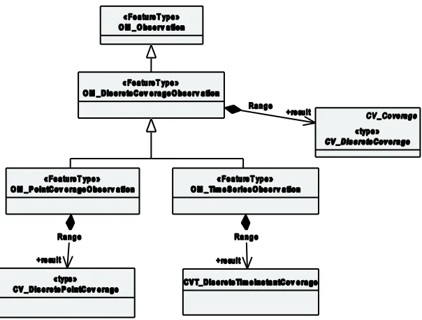
Observation types with variable results are shown in Figure 7.
For each specialized observation class whose result varies, the target of the association named ‘Range’ with the role-name ‘result’ shall be redefined as indicated in Figure 7 and Table 4.
Table 4 — Result types for specialized observations
Specialized observation class Result type
OM_ DiscreteCoverageObservation CV_DiscreteCoverage
OM_ DiscretePointCoverageObservation CV_DiscretePointCoverage
Figure 7 — Specialization of observations with coverage-valued results
9 Fundamental characteristics of sampling features
9.1 The context for sampling
9.1.1 Proximate vs. ultimate feature-of-interest
9.1.1.1 Introduction
The observation model maps the result of the application of a procedure to a subject, which plays the role of feature-of-interest of the observation (Clause 7). However, the proximate feature-of-interest of an observation may not be the ultimate domain-specific feature whose properties are of interest in the investigation of which the observation is a part. There are two circumstances that can lead to this:
a) the observation does not obtain values for the whole of a domain feature;
b) the observation procedure obtains values for properties that are not characteristic of the type of the ultimate feature.
Furthermore, in some practical situations, both differences apply.
9.1.1.2 Proximate feature-of-interest embodies a sample design
For various reasons, the domain feature may not be fully accessible. In such circumstances, the procedure for estimating the value of a property of the domain feature involves sampling in representative locations. Then the procedure for transforming a property value observed on the sample to an estimate of the property on the ultimate feature-of-interest depends on the sample design.
EXAMPLE 1 The chemistry of water in an underground aquifer is sampled at one or more positions in a well or bore.
EXAMPLE 2 The magnetic field of the earth is sampled at positions along a flight-line.
9.1.1.3 Observed property is a proxy
The procedure for obtaining values of the property of interest may be indirect, relying on direct observation of a more convenient parameter which is a proxy for the property of interest. Application of an algorithm or processing chain obtains an estimate of the ultimate property of interest.
The observation model requires that the feature-of-interest of the initial observation be of a type that carries the observed property within its properties. Thus, if the proxy property is not a member of the ultimate feature-of-interest, a proxy feature with a suitable model shall be involved.
EXAMPLE A remote sensing observation might obtain the reflectance colour, when the investigation is actually interested in vegetation type and quality. The feature which contains reflectance colour is a scene or swath, while the feature carrying vegetation properties is a parcel or tract.
9.1.1.4 Combination
These variations may be combined if exhaustive observation of the domain feature is impractical, and direct measurement is of a proxy property.
EXAMPLE For certain styles of mineralization, the gold concentration of rocks in a region might be estimated through measurement of a related element (e.g. copper), in a specimen of gravel collected from a stream that drains part of the region. The gravel samples the rocks in the catchment of the stream, i.e. in the stream bed and upslope.
9.1.2 Role of sampling features
Sampling features are artefacts of an observational strategy, and have no significant function outside of their role in the observation process. The physical characteristics of the features themselves are of little interest, except perhaps to the manager of a sampling campaign.
EXAMPLE A “station” is essentially an identifiable locality where a sensor system or procedure may be deployed and an observation made. In the context of the observation model, it connotes the “world in the vicinity of the station”, so the observed properties relate to the physical medium at the station, and not to any physical artefact such as a mooring, buoy, benchmark, monument, well, etc.
NOTE A transient sampling feature, such as a ships-track or flight-line, might be identified and described, but is unlikely to be revisited exactly.
A sampling feature is intended to sample some feature-of-interest in an application domain. However, in some cases the identity, and even the exact type, of the sampled feature may not be known when observations are made using the sampling features.
9.1.3 Classification of sampling features
A small number of sampling patterns are common across disciplines in observational science. These provide a basis for processing and portrayal tools which are similar across domains, and depend particularly on the geometry of the sample design. Common names for sampling features include specimen, station, profile, transect, path, swath and scene. Spatial sampling is classified primarily by the topological dimension. The generic characteristics of sampling features are defined in this clause; spatial samples of various dimensions are defined in Clause 10; and specimens in Clause 11.
9.2 Sampling Schema
9.2.1 Packaging
geographic information. The inter-package dependencies are shown in Figure 8. The core sampling feature package is documented in this clause. The spatial sampling feature packages are documented in Clause 10 and the specimen package in Clause 11.
Figure 8 — Package dependencies of the sampling feature schema
9.2.2 SF_SamplingFeature
9.2.2.1 General
Figure 9 — Sampling feature core
9.2.2.2 parameter
If present, the attribute parameter:NamedValue shall describe an arbitrary parameter associated with the SF_SamplingFeature. This might be a parameter that qualifies the interaction with the sampled feature, or an environmental parameter associated with the sampling process.
9.2.2.3 lineage
If present, the attribute lineage:LI_Lineage shall describe the history and provenance of the SF_SamplingFeature. This might include information relating to the handling of the specimen, or details of the survey procedure of a spatial sampling feature.
9.2.2.4 Intention
A sampling feature is established in order to make observations concerning some domain feature. The association Intention shall link the SF_SamplingFeature to the feature which the sampling feature was designed to sample. The target of this association has the role sampledFeature with respect to the sampling feature, and shall not be a sampling feature or observation. It is usually a real-world feature from an application domain (Figures 5 and 10).
Figure 10 — (Informative) Relationship between sampling and domain features
(Each may appear as the feature-of-interest. If a sampling feature is involved, it samples a feature of a type defined in an application schema.)
NOTE 1 The sampling feature, together with the observation procedure, describes the observation protocol.
NOTE 2 GFI_DomainFeature is informative only. It stands for all feature types that are not observations or sampling features.
9.2.2.5 Design
Sampling features are distinctive compared with other features from application domains by having navigable associations to observations. If present, the association Design shall link the SF_SamplingFeature to an OM_Observation that was made utilizing the sampling feature, and the description of the sampling feature provides an intrinsic element of the observation protocol, along with the observation procedure (7.2.2) and the decomposition of the domain geometry in the case of a coverage-valued result (8.3). The OM_Observation has the role relatedObservation with respect to the sampling feature. Multiple observations may be made on a single sampling feature.
9.2.2.6 Constraint
A constraint on OM_Observation is that its observed property is a member property of the feature-of-interest either directly or transitively. Where the feature-of-interest of an observation is a sampling feature, the observed property shall be a member of the sampling feature or of the sampled feature.
Where the identity or type of the sampled feature is not known prior to processing the observation result, the constraint cannot be enforced immediately.
9.2.3 SamplingFeatureComplex
9.2.3.1 General
Sampling features are frequently related to each other, as parts of complexes, through sub-sampling, and in other ways. If present, the association class SamplingFeatureComplex (Figure 9) shall link an SF_SamplingFeature to another SF_SamplingFeature. It shall support one attribute.
This association complements the Intention association which describes relationships between a sampling feature and domain features.
9.2.3.2 role
The attribute role:GenericName shall describe the relationship of the target SF_SamplingFeature to the source SF_SamplingFeature.
9.2.4 SF_SamplingFeatureCollection
9.2.4.1 General
The class SF_SamplingFeatureCollection (Figure 9) is an instance of the «metaclass» GF_FeatureType (ISO 19109), which therefore represents a feature type. SF_SamplingFeatureCollection shall support one association.
9.2.4.2 Collection
The association Collection shall link an SF_SamplingFeatureCollection to member SF_SamplingFeatures.
10 Spatial sampling features
10.1 The context for spatial sampling features
When observations are made to estimate properties of a geospatial feature, in particular where the value of a property varies within the scope of the feature, a spatial sampling feature is used. Depending on accessibility and on the nature of the expected property variation, the sampling feature may be extensive in one, two or three spatial dimensions. Processing and visualization methods are often dependent on the topological dimension of the sampling manifold, so this provides a natural classification system for sampling features.
This classification follows common practice in focussing on conventional spatial dimensions. Properties observed on sampling features may be time-dependent, but the temporal axis does not generally contribute to the classification of sampling feature classes. Sampling feature identity is usually less time-dependent than the property value.
10.2 Spatial sampling feature schema
10.2.1 SF_SpatialSamplingFeature
10.2.1.1 General
Figure 11 — Spatial sampling features
10.2.1.2 positionalAccuracy
Positioning metadata is commonly associated with sampling features defined in the context of field surveys. If present, positionalAccuracy:DQ_PositionalAccuracy shall describe the accuracy of the positioning of the sampling feature. Up to two instances of the attribute support the independent description of horizontal and vertical accuracy.
10.2.1.3 Geometry
The association Geometry shall link an SF_SpatialSamplingFeature to a GM_Object that describes its shape.
10.2.1.4 Platform
A common role for a spatial sampling feature is to host instruments or procedures deployed repetitively or permanently. If present, the association Platform shall link the SF_SpatialSamplingFeature to an OM_Process deployed at it. The OM_Process has the role hostedProcedure with respect to the sampling feature.
10.2.2 Taxonomy of spatial sampling features
Concrete spatial sampling feature classes shall be distinguished on the basis of the type of the shape property, as shown in Figure 11 and Table 5.
Table 5 — Shape types for specialized spatial sampling features
Specialized spatial sampling feature Shape type
SF_SamplingPoint GM_Point
SF_SamplingCurve GM_Curve
SF_SamplingSurface GM_Surface
The specialization of sampling features follows common practice in focussing on conventional spatial dimensions. Properties observed on sampling features may be time-dependent, but the temporal axis does not generally contribute to the classification of sampling feature classes. Sampling feature identity is usually less time-dependent than property value.
10.3 Decomposition of extensive sampling features for observations
The shape of a spatially extensive sampling feature (sampling-curve, -surface or -solid) defines a manifold within which a varying property may be characterized, and hence within which subsampling may be undertaken. The shape provides a complete sampling domain, but does not specify any particular decomposition. Sub-sampling may be described using related sampling features, or as domain elements (such as a segment in a 1-D curve; grid-cell, pixel or TIN triangle in 2-D; tetrahedron or block in 3-D) of a discrete coverage representation of the variation of a property within the sampling feature. The shape of the sampling feature is the context for domain decomposition. Where spatial sampling is involved, then both the sampling feature shape and its discretization as described in the domain of the coverage that comprises the observation result are required to describe the overall observation protocol.
EXAMPLE 1 Logs of different properties along a well or borehole might use different intervals, and sub-samples might be either spatially instantaneous, or averaged in some way over an interval. The position of the samples can be conveniently described in terms of offsets in a linear coordinate reference system that is defined by the shape of the well axis.
Time-dependent properties may be observed if a sampling feature is temporally persistent.
EXAMPLE 2 The temperature of the atmosphere at a weather station varies as a function of time.
Properties observed using a sampling feature may depend on non-spatiotemporal axes.
EXAMPLE 3 The density of a specimen varies as a function of temperature.
10.4 Common names for sampling features (informative)
Figure 12 — (Informative) Common terms for spatially extensive sampling features (i.e. the classes whose names are unprefixed)
11 Specimens
11.1 The context for specimens
A Specimen is a physical sample, obtained for observation(s) normally carried out ex-situ, sometimes in a laboratory.
11.2 Specimen schema
11.2.1 SF_Specimen
11.2.1.1 General
Figure 13 — Specimen model
11.2.1.2 materialClass
The attribute materialClass:GenericName shall provide a basic classification of the material type of the specimen.
EXAMPLE Soil, water, rock, aqueous, liquid, tissue, vegetation, food.
11.2.1.3 samplingTime
The attribute samplingTime:TM_Object shall record when the specimen was retrieved from the sampled feature.
11.2.1.4 samplingLocation
If present, the attribute samplingLocation:GM_Object shall describe the location from where the specimen was obtained.
NOTE Where a specimen has a relatedSamplingFeature whose location provides an unambiguous location then this attribute is not required. However, if the specific sampling location within the sampledFeature is important, then this attribute supports its description.
11.2.1.5 samplingMethod
If present, the attribute samplingMethod:SF_Process shall describe the method used to obtain the specimen from its sampledFeature.
11.2.1.6 currentLocation
NOTE If a specimen no longer exists, for example, it was destroyed in connection with an observation act, then the currentLocation should be omitted or carry a suitable null indicator.
11.2.1.7 specimenType
If present, the attribute specimenType:GenericName shall describe the basic form of the specimen.
EXAMPLE Polished section; core; pulp; solution.
11.2.1.8 size
If present, the attribute size:Measure shall describe a physical extent of the specimen. This may be length, mass, volume, etc., as appropriate for the specimen instance and its material class.
11.2.2 PreparationStep
11.2.2.1 General
In many applications, specimen preparation procedures are applied to the material prior to its use in an observation. The class PreparationStep (Figure 13) shall link an SF_Specimen to an SF_Process that describes a phase of the specimen preparation. It shall support two attributes.
11.2.2.2 time
The attribute time:TM_Object shall describe the time that the SF_Process was applied to the SF_Specimen. It supports ordering of preparation steps.
11.2.2.3 processOperator
If present, the attribute processOperator:CI_ResponsibleParty shall describe the operator of the process involved in the preparation step.
11.2.3 SF_Process
The class SF_Process (Figure 13) is an instance of the «metaclass» GF_FeatureType (ISO 19109), which therefore represents a feature type. The SF_Process is abstract, and has no attributes, operations or associations. It serves as the base class for processes associated with the design and preparation of sampling features. The purpose of a sampling process is to generate or transform a sampling feature.
11.2.4 Location
11.2.4.1 General
Location (Figure 13) is a union class (choice) that shall support two attributes.
11.2.4.2 geometryLocation
The attribute geometryLocation:GM_Object shall select a geometric representation of the location.
11.2.4.3 nameLocation
Annex A
(normative)
Abstract Test Suite
A.1 Abstract tests for observation interchange
A.1.1 Observation interchange
The observation interchange test consists of the following:
a) Test Purpose: Verify that an interchange schema correctly implements the mandatory attributes, associations and constraints of OM_Observation.
b) Test Method: Inspect the documentation of the interchange schema.
c) Reference: ISO 19156, Clause 7.
d) Test Type: Capability.
A.1.2 Measurement interchange
The measurement interchange test consists of the following:
a) Test Purpose: Verify that an interchange schema correctly implements the mandatory attributes, associations and constraints of OM_Measurement.
b) Test Method: Inspect the documentation of the interchange schema.
c) Reference: ISO 19156, 8.2.2.
d) Test Type: Capability.
A.1.3 Category observation interchange
The category observation interchange test consists of the following:
a) Test Purpose: Verify that an interchange schema correctly implements the mandatory attributes, associations and constraints of OM_CategoryObservation.
b) Test Method: Inspect the documentation of the interchange schema.
c) Reference: ISO 19156, 8.2.2.
d) Test Type: Capability.
A.1.4 Count observation interchange
The count observation interchange test consists of the following:
b) Test Method: Inspect the documentation of the interchange schema.
c) Reference: ISO 19156, 8.2.2.
d) Test Type: Capability.
A.1.5 Truth observation interchange
The truth observation interchange test consists of the following:
a) Test Purpose: Verify that an interchange schema correctly implements the mandatory attributes, associations and constraints of OM_TruthObservation.
b) Test Method: Inspect the documentation of the interchange schema.
c) Reference: ISO 19156, 8.2.2.
d) Test Type: Capability.
A.1.6 Temporal observation interchange
The temporal observation interchange test consists of the following:
a) Test Purpose: Verify that an interchange schema correctly implements the mandatory attributes, associations and constraints of OM_TemporalObservation.
b) Test Method: Inspect the documentation of the interchange schema.
c) Reference: ISO 19156, 8.2.2.
d) Test Type: Capability.
A.1.7 Geometry observation interchange
The geometry observation interchange test consists of the following:
a) Test Purpose: Verify that an interchange schema correctly implements the mandatory attributes, associations and constraints of OM_GeometryObservation.
b) Test Method: Inspect the documentation of the interchange schema.
c) Reference: ISO 19156, 8.2.2.
d) Test Type: Capability.
A.1.8 Complex observation interchange
The complex observation interchange test consists of the following:
a) Test Purpose: Verify that an interchange schema correctly implements the mandatory attributes, associations and constraints of OM_ComplexObservation.
b) Test Method: Inspect the documentation of the interchange schema.
d) Test Type: Capability.
A.1.9 Discrete coverage observation interchange
The discrete coverage observation interchange test consists of the following:
a) Test Purpose: Verify that an interchange schema correctly implements the mandatory attributes, associations and constraints of OM_DiscreteCoverageObservation.
b) Test Method: Inspect the documentation of the interchange schema.
c) Reference: ISO 19156, 8.3.2.
d) Test Type: Capability.
A.1.10 Point coverage observation interchange
The point coverage observation interchange test consists of the following:
a) Test Purpose: Verify that an interchange schema correctly implements the mandatory attributes, associations and constraints of OM_PointCoverageObservation.
b) Test Method: Inspect the documentation of the interchange schema.
c) Reference: ISO 19156, 8.3.2.
d) Test Type: Capability.
A.1.11 Time series observation interchange
The time series observation interchange test consists of the following:
a) Test Purpose: Verify that an interchange schema correctly implements the mandatory attributes, associations and constraints of OM_TimeSeriesObservation.
b) Test Method: Inspect the documentation of the interchange schema.
c) Reference: ISO 19156, 8.3.2.
d) Test Type: Capability.
A.2 Abstract tests for sampling feature interchange
A.2.1 Sampling feature interchange
The sampling feature interchange test consists of the following:
a) Test Purpose: Verify that an interchange schema correctly implements the mandatory attributes, associations and constraints of a concrete subclass of SF_SamplingFeature.
b) Test Method: Inspect the documentation of the interchange schema.
c) Reference: ISO 19156, Clauses 9, 10 and 11.