Open Geospatial Consortium
Document OGC 08-166r1
CR-Form-v3
CHANGE REQUEST
WCS CR ?
rev
-
Current version:
1.1 corr. 2
For
HELP
on using this form, see bottom of this page or look at the pop-up text over the
symbols.
Proposed change affects:
AS
Imp Spec
X
Best Practices Paper
Other
Title:
WCS change request - Expand output coverage metadata
Source:
Arliss Whiteside, WCS 1.2 SWG
Work item code:
Date:
2008-
1112
-0420
Category:
C
Use one of the following categories: F (Critical correction)
A (corresponds to a correction in an earlier release) B (Addition of feature),
C (Functional modification of feature) D (Editorial modification)
Reason for change:
The metadata required with a WCS output coverage is not sufficient for all
client uses, in
sS
ubclause 7.3.9 of WCS 1.1 Corrigendum 2 [OGC
07-067r5].
Summary of change:
Expand and modify the metadata required with a WCS output coverage, in
Subclause
s
7.3.9 of WCS 1.1 Corrigendum 2, partially based on
discussions in the WCS 1.2 SWG, including:
a) Add Range of output coverage
b) Expand domain of output coverage to include temporal domain
c)
Add ability to reference additional output coverage metadata
d) Recommend use of wcs:CoverageDescription to combine metadata
OGC 08-166r1
Consequences if
not approved:
Continued insufficient and unclear metadata required with a WCS output
coverage, leading to more work by clients and confusion by WCS server
and client implementers
Clauses affected:
710
.3.9
, 9.3.1.1
Other specs
Other core specifications
Affected:
Abstract specifications
Best Practices Papers
Supporting Doc.
Other comments:
Status
Disposition
Edit Subclause
710
.3.9 as follows:
710
.3.9 Output coverage metadata
The metadata listed in Table 30, or the equivalent information, shall be included with each
WCS output coverage. Equivalent metadata may be encoded with the coverage data in some
possible coverage formats, as specified by a WCS encoding extension document (see 9.3.2.2
above).
Such metadata may be XML encoded using the XML data type listed in Table 30.
A
WCS encoding extension
document may specify encoding equivalent metadata both within a
specialized coverage format and outside that format, but such duplication is discouraged to
avoid consistency issues. When any metadata is encoded both with and outside the coverage
data, that duplicated metadata shall be as consistent as possible.
OGC 08-166r1
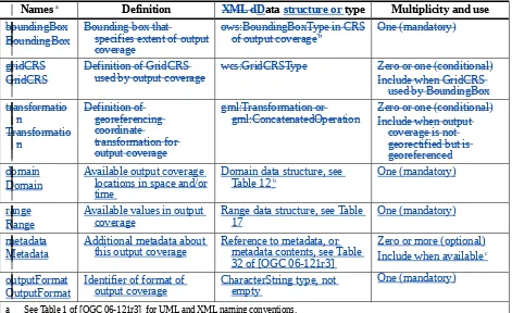
Table 30 — Required output coverage metadata
Names
aDefinition
XML dD
ata
structure or
type
Multiplicity and use
boundingBox
BoundingBox
Bounding box that
specifies extent of output
coverage
ows:BoundingBoxType in CRS
of output coverage
bOne (mandatory)
gridCRS
GridCRS
Definition of GridCRS
used by output coverage
wcs:GridCRSType
Zero or one (conditional)
Include when GridCRS
used by BoundingBox
gml:ConcatenatedOperation
Zero or one (conditional)
Include when output
coverage is not
georectified but is
georeferenced
domain
Domain
Available output coverage
locations in space and/or
time
Domain data structure, see
Table 12
b
One (mandatory)
range
Range
Available values in output
coverage
Range data structure, see Table
17
One (mandatory)
metadata
Metadata
Additional metadata about
this output coverage
Reference to metadata, or
metadata contents, see Table
32 of [OGC 06-121r3]
Zero or more (optional)
Include when available
coutputFormat
OutputFormat
Identifier of format of
output coverage
CharacterString type, not
empty
One (mandatory)
a See Table 1 of [OGC 06-121r3] for UML and XML naming conventions.
b The Coordinate Reference System (CRS) of an output coverage may be either a GridCRS or an ImageCRS. This Domain data
structure shall include at least the BoundingBox of the output coverage, the GridCRS definition when used by that BoundingBox, and the Transformation when the output coverage is not georectified but is georeferenced.
c Additional output coverage metadata that is needed by or useful to some clients is expected to be available in some cases, including data quality metadata for georectified coverages and for previously processed unrectified images.
NOTE 1 Better definition of the additional output coverage metadata is left to future work.
Such metadata may be XML encoded using the WCS encoding of the data structures and types
listed in Table 30.
When all the
output coverage metadata listed is encoded in XML (inside or
outside a specialized coverage encoding format), that data should be encoded within a
CoverageDescription data structure as specified in Table 11 through Table 20. That
CoverageDescription data shall then be encoded using the wcs:CoverageDescription XML
element specified in the wcsDescribeCoverage.xsd file. That wcs:CoverageDescription should
also include the other data allowed and required in a CoverageDescription, including other
description information.
NOTE 2 Use of the wcs:CoverageDescription XML element is desirable to simplify possible use of a WCS
Transaction operation to insert this output coverage into a different (or the same) WCS server. In that use, the one
SupportedCRS will be this GridBaseCRS, and the one SupportedFormat will be this OutputFormat.
OGC 08-166r1
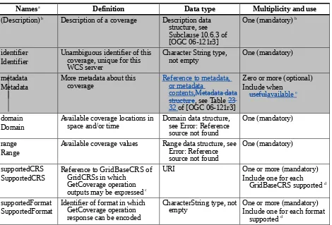
Edit Table 11 in Subclause 9.3.1.1 as follows:
Table 11 — Parts of CoverageDescription data structure
Names
aDefinition
Data type
Multiplicity and use
(Description)
bDescription of a coverage
Description data
structure, see
Subclause 10.6.3 of
[OGC 06-121r3]
One (mandatory)
bidentifier
Identifier
Unambiguous identifier of this
coverage, unique for this
WCS server
Character String type,
not empty
One (mandatory)
metadata
Metadata
More metadata about this
coverage
Reference to metadata,
or metadata
contents,Metadata data
structure
, see Table
23
32
of [OGC 06-121r3]
Zero or more (optional)
Include when
usefulavailable
e
domain
Domain
Available coverage locations in
space and/or time
Domain data structure,
see Error: Reference
source not found
One (mandatory)
range
Range
Available coverage values
Range data structure, see
Error: Reference
source not found
One (mandatory)
supportedCRS
SupportedCRS
Reference to GridBaseCRS of
GridCRSs in which
GetCoverage operation
outputs may be expressed
cURI
One or more (mandatory)
Include one for each
GridBaseCRS supported
dsupportedFormat
SupportedFormat
Identifier of format in which
GetCoverage operation
response can be encoded
CharacterString type, not
empty
One or more (mandatory)
Include one for each format
supported
da See Table 1 of [OGC 06-121r3] for UML and XML naming conventions.
b Contents inherited, not included as a named data structure. Normally includes only one Metadata item, but may include more than
one when used here, especially for an unrectified but georeferenced image coverage.
c A SupportedCRS may be referenced as the GridBaseCRS of a GridCRS specified in the Output part of a GetCoverage request. The
GridBaseCRS of the GridCRS of a georectified offered coverage shall be listed as a SupportedCRS. An ImageCRS for an unrectified offered image shall be listed as a SupportedCRS, so that it may be referenced as the GridBaseCRS of a GridCRS. This ImageCRS shall be the ImageCRS of that unrectified offered image, or the ImageCRS that is referenced as the GridBaseCRS of the GridCRS that is used by that unrectified offered image In addition, the GetCoverage operation output maybe expressed in the ImageCRS or GridCRS of an unrectified offered coverage, instead of in a specified GridCRS. These SupportedCRSs can also be referenced in the BoundingBox in the DomainSubset part of a GetCoverage request.
d There may be a dependency of a SupportedCRS upon a SupportedFormat: see Subclause Error: Reference source not found.
e Additional offered coverage metadata that is needed by or useful to some clients is expected to be available in some cases, including data quality metadata for georectified coverages and for previously processed unrectified images.