AUTOMATIC DAMAGE DETECTION FOR SENSITIVE CULTURAL HERITAGE SITES
D. Cerra a, *, J. Tian a, V. Lysandrou b, S. Plank aa
German Aerospace Center (DLR), Earth Observation Center (EOC), 82234 Weßling, Germany (daniele.cerra, jiaojiao.tian, simon.plank)@dlr.de
b
Cyprus University of Technology, Department of Civil Engineering and Geomatics, Archaeology and Cultural Heritage section [email protected]
Commission V, WG V/2
KEY WORDS: Cultural heritage, change detection
ABSTRACT:
The intentional damages to local Cultural Heritage sites carried out in recent months by the Islamic State (IS) have received wide coverage from the media worldwide. Earth Observation data is an important tool to assess these damages in such non-accessible areas: If a fast response is desired, automated image processing techniques would be needed to speed up the analysis. This paper shows the first results of applying fast and robust change detection techniques to sensitive areas. A map highlighting potentially damaged buildings is derived, which could help experts at timely assessing the damages to the Cultural Heritage sites in the observed images.
* Corresponding author
1. INTRODUCTION
The significance of remote sensing in “exploration, identification and documentation and in monitoring archaeological heritage in the living landscape” has been vigorously highlighted during the 11th Europae Archaeologiae
Consilium Heritage Management Symposium in 2010 (Cowley,
2011). Remote sensing applications for the aforementioned purposes bear a twofold utility, since from one hand they consist in distant non-destructive techniques and on the other hand they cover broader areas at the same time, moving from the monument level to that of landscape coverage.
When the Islamic State (IS) was rumored in the media to have destroyed cultural heritage sites in Iraq and Syria – Nimrud and Palmyra – officials could not reach the areas in person to confirm the damage. Therefore, the European Space Imaging (EUSI) supplied the Orient Department of the German Archaeological Institute (DAI) very high resolution (VHR) imagery to safely assess the situation on the ground. The images have been processed and analyzed by remote sensing experts of the German Aerospace Center (DLR). A visual analysis confirmed the destruction of several sites as claimed by the IS, such as the temple of Bel and several ancient tower tombs within Palmyra’s Valley of the Tombs (UNESCO, 1972). If change detection for damage assessment is performed by visual analysis on large areas, it becomes a difficult and time-consuming activity, and the knowledge acquired from its results could be incomplete. In the specific, damaged areas could remain undetected for an observer, if the time available for the analysis is limited.
In this paper we propose to apply a change detection algorithm to solve this problem, automatically deriving maps in which the areas suspected of having suffered damages are highlighted. We choose a robust detector in order to obtain a reliable change map if the images present co-registration errors or geometric distortions caused by different acquisition angles. The spots presenting the highest changes are highlighted to rapidly
provide a potential set of sensitive areas on which a more detailed analysis should be carried out.
The paper is structured as follows. Section 2 introduces the archeological site of Palmyra and some of the relevant monuments which suffered damages from terrorist activities. Section 3 reports the adopted change detection workflow, while experimental results are described in Section 4. We conclude in Section 5.
2. CASE STUDY
The present paper focuses on a part of the large archaeological site of Palmyra situated in the Syrian Desert north-east of Damascus. The archaeological vestiges of the ancient Roman city are listed in the UNESCO World Heritage since 1980, while from 2013 until today the site has been added to the List of World Heritage in Danger (Article 11 (4) of the World Heritage Convention) (UNESCO, 1972). The monumental ruins belong to an ancient city flourished between the 1st and 3rd century A.D., as part of the Roman Empire. Due to its geographical position, Palmyra was during antiquity a major trading center and bridging route between Mediterranean and Euphrates.
to whom the statue belonged, has dedicated the Temple of the Gods Bel, Iarhibol and Aglibol in its sanctuaries in 32 A.D. (Cantineu, 1934, UNESCO, 1972). The Semitic’s god Bel worship was dominant in the Palmyrene religious cult (Danti, 2001).
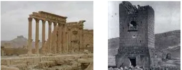
Figure 1. Temple of Bel (left) and tower tomb of Elahbel (right). Photos taken by T. Paulette in 2005 and by Wolfe Expedition in 1885, respectively.
Outside the walls of the city its ancient necropolis is to be found. Here under examination is the western necropolis, better known as Valley of the Tombs. This cemetery contains some impressive built tombs belonging to the architectural type of the tower tombs (e.g. Tower tomb of Elahbel, Tower tomb of Atenatan, Tower tomb of Julius Aurelius Bolma, Tower tomb of Kithoth Tomasu). These tombs were erected during the 1st and 2nd centuries A.D. to serve the wealthy inhabitants of the city, and their existence and preservation alongside the study of the burial customs to be detected within the tombs, consist of an important source of information for the lives of the elite class of that time. The tower tombs contained rich decoration such as wall paintings, funerary sculptures, inscriptions, and sarcophagi. Photographic documentation of the described sites is reported in Fig. 1.
3. ROBUST CHANGE DETECTION
The aim of a change detection algorithm is to provide a map of changes when given in input two or more images acquired at different times over the same area. For the applications described in this paper, the desired output should highlight the locations of monuments which suffered damages or changes in a short time span.
Nevertheless, automatic change detection techniques may be difficult to apply in practice. For example, the differences between pre- and post-event images may be difficult to obtain in a reliable way if the acquisition dates of the two images are too far away. Even if this is not the case, a pixel-based analysis is difficult to carry out even after an accurate co-registration step, as often, no high resolution Digital Surface Model (DSM) is available. In this case, images may exhibit orthorectification errors, and the differences in view angle introduce in turn pronounced geometric distortions.
Many approaches have been proposed to solve this problem,
window size 2w + 1) of the pixel X (i, j) in the pre-disaster
neighbourhood centered around i, j
This means that only the minimum value of the absolute difference is taken into account, all within the defined window size, which should be adjusted based on the scale of the occurred changes. Typically used window sizes are square and range from 3 × 3 up to 11 × 11 pixels depending on the amount of geometric distortions caused by different acquisition angles and differences between the original spatial resolution of the two available images. As the input images are multispectral, the RDs are computed for each channel separately; subsequently, their chi-distances are summed up to produce the final change map.
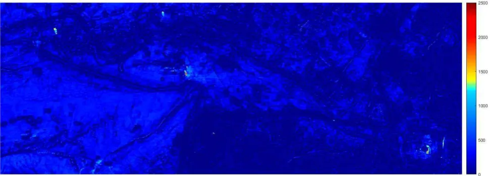
The RD is by definition robust to geometric distortions caused by differences in the terrain and to errors introduced in the co-registration step. To produce a final change map, a threshold is applied selecting all pixels with RD > 1200. Morphological filtering (opening and closing) is subsequently applied to the binary thresholded image to produce the final results.
4. EXPERIMENTS
Figs. 2 and 3 report the subsets of two WorldView-2 datasets acquired outside the city center of Palmyra, Syria, on the 27th of August and 2nd of September 2015, respectively. Henceforth we refer to these two dates as as t1 and t2.
At time t1 the Islamic State (IS) had already destroyed several Cultural Heritage (CH) sites in the area, namely the tower tombs of Atenaten, Iamliku, and the Banai family, the temple of Baalshamin, and the Abu Behaeddine shrine. Between t1 and t2, other tower tombs and the temple of Bel have been damaged. In the figures the temple of Bel is located in the bottom right, while the tower tombs are scattered in the upper left part of the image.
The available images exhibit some pronounced orthorectification errors, as no high resolution Digital Surface Model (DSM) is available. We are therefore in one of the cases for which the RD described in previous section may yield more reliable results.
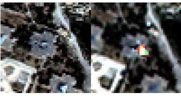
correctly detected from the algorithm, well agreeing with the report on the situation in Palmyra in (Cuneo, 2015). On the right, the destruction of the central part and the eastern wall of the temple of Bel are also detected. The only false alarm is given in the lower central part of the image due to an artifact in the dataset acquired at time t2 (see Fig. 6).
5. CONCLUSIONS
The importance of remotely sensed earth observation data has been widely acknowledged in recent years. The change detection methodology proposed in this paper is aimed at increasing the timeliness for the production of detailed damage assessment maps in CH sites in sensible areas providing the image analysts with a map of potentially damaged sites. As the process is robust and fast, it would represent a valuable, cost and time efficient tool in the hands of professionals dealing with CH management and monitoring, as important information in sensitive areas could be promptly derived, once the post-change image is available and co-registered to the pre-change acquisition.
The proposed method could be applied in similar cases to inaccessible areas of war conflict in order to obtain a rapid detection and documentation of the damages. Furthermore, the methodology is arguably appropriate for long term monitoring of cultural heritage sites in terms of their inspection against natural and anthropogenic hazards.
The methodological approach here presented could thus be imported in the general planning related to the development of risk-preparedness strategies for cultural heritage sites, as well as for the disaster-response planning. The development of strategy for the protection of CH in the event of armed conflict request regular monitoring and inspection of the condition of significant CH sites, to be undertaken as a basis of follow-up actions further underlining the need for salvage recording or documentation of threaten or damaged cultural property (Stovel, 1998).
In the future, the method could be enhanced by integrating the analysis of texture parameters extracted from the images, as destroyed sites usually appear as areas where high frequencies are predominant.
REFERENCES
Blaschke, T., 2010. “Object based image analysis for remote sensing”, ISPRS Journal of Photogrammetry and Remote Sensing vol. 65, no. 1, pp. 2-16.
J. Cantineau, 1934. Inventaire des Inscriptions de Palmyre fasc. IX: le sanctuaire de Bêl, Damascus Museum.
G. Castilla, R. H. Guthrie, G. J. Hey, 2009. “The land-cover change mapper (LCM) and its application to timber harvest monitoring in western Canada”, Photogrammetric Engineering & Remote Sensing, vol. 75, no. 8, pp. 941-950.
United Nations Educational, Scientific and Cultural Organisation (UNESCO), Convention concerning the protection of the world cultural and natural heritage, Adopted by the General Conference at its seventeenth session Paris, 16 november 1972.
D. C. Cowley (ed.), 2011. Remote Sensing for Archaeological Heritage Management, EAC Occasional Paper No. 5, Budapest.
A. Cuneo, S. Penacho, and L. Barnes Gordon, 2015. “Special Report: Update on the Situation in Palmyra”, 3 September 2015. Available online (accessed 29.03.2016) at:
http://www.asor-syrianheritage.org/special-report-update-on-the-situation-in-palmyra/
Danti M., “Palmyrene funerary sculptures at Penn”, Expedition 43 no.3, 2001.
Im, J., Jensen, J. R., Tullis, J. A., 2008. “Object based change detection using correlation image analysis and image segmentation”, International Journal of Remote Sensing, vol. 29, no. 2, pp. 399-423.
D. Löwe, 2004. “Distinctive image features from scale-invariant keypoints”, International journal of computer vision, vol. 60, no. 2, pp. 91—110.
S. Plank, G. Strunz, M. van Ess, P. Richardson, 2015. “Monitoring of cultural heritage sites using VHR earth observation data”, WorldView Global Alliance - User Conference 2015, Munich (Germany), 13.-14.Oct. 2015.
Seyrig H., Antiquités Syriennes, vol. 3, Paris 1936-1946.
Starcky J. and Munajjed S., Palmyra, The bride of the desert, Damascus 1960.
Stovel H., Risk Preparedness: A management manual for World Cultural Heritage, Rome 1998.
Figure 2. Subset of the WorldView-2 image acquired on the 27th of August 2015 (©European Space Imaging / DigitalGlobe).
Figure 5. Post-processed change map overlaid on the 2nd of September 2015 WorldView-2 image (©European Space Imaging / DigitalGlobe).
.