MODEL BYE-LAWS FOR COASTAL
MANAGEMENT IN GHANA:
EXPERIENCES FROM SHAMA DISTRICT,
WESTERN REGION
SEPTEMBER 2013
THE
UNIVERSITY of Rhode Island
GRADUATE SCHOOL OF OCEANOGRAPHY
Coastal Resources
This publication is available electronically on the Coastal Resources Center’s website at http://www.crc.uri.edu
For more information contact: Coastal Resources Center, University of Rhode Island,
Narragansett Bay Campus, South Ferry Road, Narragansett, Rhode Island 02882, USA. Brian Crawford, Director International Programs at Email: brian@crc.uri.edu; Tel: 401-874-6224; Fax: 401-874-6920
Friends of the Nation: http://www.fonghana.org
Hen Mpoano: http://www.henmpoano.org
Citation: Kankam, S., Robadue D. (2013) Model Bye-laws for Coastal Management in Ghana: Experiences from Shama District, Western Region. Integrated Coastal and Fisheries Governance Initiative (ICFG) for the Western Region of Ghana. Narragansett, RI: Coastal Resources Center, Graduate School of Oceanography, University of Rhode Island, and Friends of the Nation. 22 Pages.
Disclaimer: This publication is made possible by the generous support of the American people through the United States Agency for International Development (USAID)/Ghana. The contents of this report are the responsibility of the Integrated Coastal and Fisheries Governance (ICFG) Program and do not necessarily reflect the views of the United States Government. Associate Cooperative Agreement No. 641-A-00-09-00036-00 for “Integrated Coastal and Fisheries Governance (ICFG) Program for the Western Region of Ghana”, under the Leader with Associates Award No. EPP-A-00-04-00014-00.
Table of Contents
Table of Contents --- ii
List of Figures --- ii
Introduction --- 1
CHAPTER ONE Technical Report Supporting the Anankwar Flood Hazard Prevention and Mitigation Bye-law --- 2
1.1 Background --- 2
1.2 Statement of Objectives --- 2
1.3 Definitions --- 3
1.4 Boundary Description --- 3
1.5 Policies for Occupation, Use and Development of Flood Hazard Zones A, B, and C --- 4
1.6 Standards for New Construction in Floodplain Hazard Zone C of the Floodplain --- 5
1.7 Permitting Procedures and Requirements for Uses and Development in Floodplain Hazard Zones --- 6
1.8 Emergency Response Plan --- 7
1.9 Coordination --- 7
1.10 Maps --- 7
CHAPTER TWO Technical Report Supporting the Pra River Estuary and Wetland Conservation Bye-law --- 9
2.1 Background --- 9
2.2 Statement of objectives --- 10
2.3 Definitions --- 10
2.4 Boundary Description --- 10
2.5 Policies for Conservation of the Estuary and Wetland System --- 11
2.6 Criteria and Consideration for Management --- 11
2.7 Management plan --- 11
2.8 Management committee --- 12
2.9 Funding --- 12
2.10 Development --- 12
2.11 Advisory Services and Support --- 13
CHAPTER THREE Technical Report Supporting Shama District Shoreline Management Bye-law --- 15
3.1 Background --- 15
3.2 Coastal Features --- 15
3.3 Uses of the Coastal Zone --- 15
3.4 Statement of Objectives --- 16
3.5 Definitions --- 16
3.6 Conservation, Protection and Recreation Use Zone --- 17
3.7 Mixed Uses with Fishing, High and Low Density Housing Zone --- 17
3.8 Waterfront Industrial zone --- 18
3.9 Tourism and Recreation Zone --- 18
List of Figures
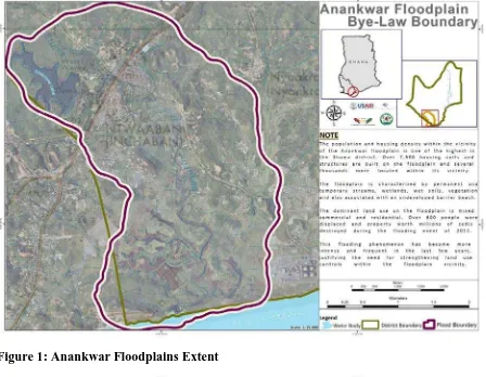
Figure 1: Anankwar Floodplains Extent 8
Figure 2: Anankwar Floodplain Zones 8
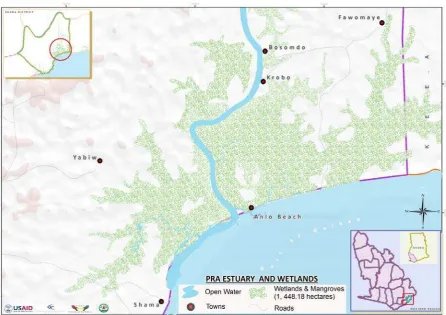
Figure 3: Pra Estuary and Wetlands 14
Introduction
District Assemblies in Ghana are vested with authority under the Local Government Act of
1993 (Act 462) to enact bye-laws to regulate activities in their areas of jurisdiction. The
Shama district assembly explored this authority to develop and adopt policies and regulations for shoreline management, preventing and mitigating flood hazards, and conservation of one of its most significant wetland ecosystems. These bye-laws have been generated through technical assessments and extensive consultations with stakeholders that will be affected during their implementation. The bye-laws incorporate policies for land management and emergency response as measures to support development permitting decision making and improve preparedness for flood emergencies. They also set the enabling framework for the development of management plans for the Pra Estuary and wetland system and zoning of shorefront areas for different uses. District committees, notably the statutory planning committee, technical sub-committee as well as the district National Disaster Management Organization (NADMO) will find these bye-laws useful as part of delivering their statutory mandate.
CHAPTER ONE
Technical Report Supporting the Anankwar Flood Hazard Prevention and Mitigation Bye-law
1.1 Background
During the past few decades, flooding has claimed lives and damaged property worth millions of cedis in the communities abutting the Anankwar floodplain. Flooding occurs in flash events of short duration but intense rainfall, as well as extended periods of rainfall that saturate the soil of the entire drainage basin and overtop catchment areas, leading to large volumes of runoff and the accumulation of water in wetlands and the flood plain. Major contributing factors to flooding include topography, soils, the amount of stabilizing land cover, as well as land uses that prevent water absorption. The scarification of hillsides exposing soil to erosion, the creation of impervious cover due to filling and construction within the drainage area, and poorly conceived storm water drainage systems all reduce the water retention potential of the drainage basin, sending greater volumes of water to flood plain and increasing flood risk.
The population and housing density in the Anankwar area is one of the highest in the Shama district. Over 7,500 housing units and structures are built on the floodplain and several thousands more are located within the floodplain vicinity. The dominant land use patterns on the floodplain shows a mixed residential and commercial use. The assessment of flood hazard in the Anankwar area reveal that large portions of the floodplain, majority of the resident human population, including the elderly and children, as well as livestock are vulnerable to flood risks. The assessment also revealed that public schools, day care centres,
telecommunication and water infrastructure are susceptible to flooding. Flood risk is particularly high for the population, property and infrastructure along the banks of the main river channel and on the undeveloped portions of the floodplain contiguous to the barrier beach. In these areas, over 600 people were displaced and property worth millions of cedis destroyed during the flooding event of 2011. Overall, the assessment showed that flooding has become more intense and frequent in the last few years, justifying the need for
strengthening land use controls within the floodplain vicinity.
In 2012, a series of consultations was held with traditional authorities, district officials, prospective developers and inhabitants of communities abutting the floodplain – Aboadze, Lower Inchaban and Upper Inchaban - to discuss the nature and impacts of the flooding problem and to think through some proactive approaches for addressing flooding. Diverse stakeholder views have consequently been captured and accommodated in the bye-law.
1.2 Statement of Objectives
The objectives of this bye-law are to:
protect public health, safety and property in the communities abutting the Anankwar a)
river and floodplain.
minimize flood damage in the floodplain and insure that new construction including b)
housing, businesses and public infrastructure handles storm water on site and does not increase the hazards faced by already existing uses and property.
maintain a sound and growing local economy and tax base by preventing long term c)
losses to businesses.
reduce the number of emergencies in the floodplain and its vicinity and minimize the d)
ensure that those obtaining building permits and prospective developers are fully e)
aware of the risks of development of property in flood hazard zones.
1.3 Definitions
Built Areas Highly Exposed to Flood Damage are settlements, businesses, residences and public buildings which are routinely submerged by flood waters, erosion or damage from high velocity stream and drainage flow.
Development is any man-made alteration to the landscape including grading, filling, dredging, extraction, storage, subdivision of land, or construction of structures, stormwater collection, drainage and discharge works, flood protection works.
Flash flood. A rapid rise and overflow of water caused by intense amounts of rain within a short period of time, usually 6 hours.
Flood. An overflow of rain water or other sources along a stream, drainage way or other water body that causes or threatens damage to property, infrastructure, people, or natural resources.
Flood Hazard Boundary Map is the official map maintained on file in paper as well as digital formats by the District of Shama, upon which the boundaries of the flood hazard zone has been delineated. It is periodically updated as new information becomes available.
Floodplain Hazard Zone C is an expanse of relatively flat land that spans from the main stem of a river or stream, possessing wet soils that include sediment carried and dropped by the stream, and is susceptible to being inundated by periodic flood waters from any source with a probability of 1 in 25 in a given year. This zone incorporates the river buffer zone A and the high Flood Hazard Zone B.
Flood proofing or protection means any combination of structural and non-structural additions, changes, or adjustments to existing or new structures which reduce or eliminate flood damage to residential and non-residential buildings and their contents. These can include protective walls and drainage systems to redirect water away from existing buildings, rebuilding structures to make them more resistant to the intrusion of flood waters or the physical force of high velocity water. It also includes special design and construction
techniques including piers and elevating the lowest usable floor of a building above the level of water experienced in events described in Flood Hazard Zone C.
High Flood Hazard Zone B is the additional land and wetlands which lie within and form part of the boundaries of the flood zone as illustrated in the Flood Hazard Boundary Map. This area has a probability of 1 in 5 or 20 % in a given year to be covered by floodwater during a period of intense rainfall, as well as have temporary extensive areas of standing water, and also includes permanent and seasonal wetlands and normal river flow.
Mandatory River Buffer Zone A is a land area on or contiguous to the main river channel or wetland that shall be retained in its natural or undisturbed condition. This includes
wetlands vegetation, wet soils, slopes and vegetative cover within 300 feet measured from the bank of the main river channel.
1.4 Boundary Description
km and is applicable within four (4) established boundary pillars (BP). BP 1 is located on Lat
km/1.68miles and at a bearing of 180ofrom BP1.
1.5 Policies for Occupation, Use and Development of Flood Hazard Zones A, B, and C a) It is the Shama District Assembly’s policy to maintain undeveloped floodplains in their natural conditions for enhancement of flood control functions, to ensure ‘‘no net loss’’ of wetlands in the area covered by this bye-law, and where possible to restore portions of the flood plain that are critical for the functioning of the flood plain system and for increasing public safety.
1. Any permissible developments in Flood Hazard Zones A, B and C must demonstrate that they will not increase flood hazard to adjoining property and infrastructure or threaten public safety and health within the flood plain vicinity. The aim is to protect abutters and downstream residents and businesses from bearing an increased burden of damage which is otherwise avoidable and caused by the permitted project.
2. Development of the undeveloped barrier beach contiguous to the floodplain shall be prohibited and the barrier shall be preserved to maintain its protective functions of preventing erosion and storm damage to the Anankwar and existing facilities. 3. The Assembly shall issue, modify or deny permits for development or any other
physical alteration within the high flood hazard zone and the contiguous areas which are necessary to preserve the integrity of the floodplain system.
b) Mandatory River Buffer Zone A: Building of structures in the main river channel and within the boundaries of the Mandatory River Buffer Zone A is prohibited. Special exceptions can be made only for minimal physical modifications required to install infrastructure as part of an approved comprehensive flood management and stormwater management plan whose primary purpose is to provide a benefit to the public. It must be demonstrated that the proposed development will not disrupt the vegetative cover within the buffer and the integrity of the water way.
c) High Flood Hazard Zone B: Development (any man-made change to land including grading, filling, dredging, extraction, storage, subdivision of land, construction of structures for commercial or residential use) within the High Flood Hazard Zone B is restricted to those proposals where the applicant is able to demonstrate that the proposed activity serves a compelling public purpose which provides benefit to the public as a whole as opposed to individual or private interests. The activity must be associated with public infrastructure such as utility, energy, communications, recreation or transportation facilities and represent the only viable economic and engineering choice among two or more options.
Structures damaged more severely and also that do not serve a primarily public service as stipulated above may not be rebuilt in the same location, and should be moved out of Zone A and Zone B to a permissible and safe location.
Certain intensively developed areas within the high hazard A and B zones may be designated as area of high priority for an integrated flood protection design and installation. Any flood protection project must follow the policies and principles in this bye-law and be part of the structural development plan for the urban area adjacent to the Anankwar.
e) Floodplain Hazard Zone C:
1. Where development on the flood plain is permissible necessary in Hazard Zone C, it shall be based on sound construction standards to minimize disruption of the natural flood control functions of the floodplain, and to minimize any damage to structures and uses from expected periodic floods.
2. The primary permissible uses in Zone C will be specified in a structural development plan or local development plan and may include:
Facilities and infrastructure serving public functions as roadways, bridges, access points, sewer lines, electric and telephone lines, and recreational facilities;
Flood protection and control structures required to protect Built Areas Highly Exposed to Flood Damage including those located in Zone C.
Residential, commercial or industrial facilities as allowed in the structural plan or local plan that also meet the flood proofing requirements as specified in the following sections.
3. All new construction in Floodplain Hazard Zone C shall meet both the national building code standards and additional requirements as set out below in Part 1.3 to achieve the flood hazard management policies stated in 1.2 above.
1.6 Standards for New Construction in Floodplain Hazard Zone C of the Floodplain These standards are in addition to the national building code, and shall include but not limited to the following:
a) Permissible Residential buildings shall be flood proofed and a qualified registered professional engineer or architect shall certify compliance with the following flood proof criteria:
1. Design structures so that the living space is above the maximum height of expected flood water in a 1 in 25 probability flood event.
2. Parallel concrete walls or pilings rather than fill shall be used to elevate habitable residential structures.
3. Proposed floor elevation shall be clearly indicated on building plans and submitted with the completed building permit application to the Assembly
4. Building plans shall clearly indicate designed water flow opening for enclosed space below minimum floor elevation.
5. The space between the lowest floor and between pilings shall be kept free of
habitation or for the enclosure of any utility or item essential to the structure unless such items are flood proofed.
6. All required minimum elevations for building floors or components shall be confirmed by a certified survey prior to subsequent building inspections
7. Where building is within the vicinity of a road passing through the floodplain, the elevation shall be no lower than one foot above the lowest adjacent road crest.
b) Non-residential buildings shall be flood proofed and a qualified registered
professional engineer or architect shall certify compliance with the following flood proof criteria:
1. All areas of the building components designed to be lower than the flood water height are water tight with walls designed to be substantially impermeable to the passage of water.
2. Materials and utility equipment for construction shall be resistant to flood damage. 3. Construction shall be done using methods and practices that reduce flood damage.
Any proposed development that creates an impervious cover of area in excess of 2.5 acres shall mitigate for loss of natural flood control functions through investing in the replacement or enhancement of adjacent floodplain or wetland in the district.
1.7 Permitting Procedures and Requirements for Uses and Development in Floodplain Hazard Zones
No structure or land shall be located, extended, converted, developed, built or structurally altered without full compliance of the terms of this bye-law and other applicable regulations. A building permit shall be required in conformance with the provisions of this bye-law and relevant building codes prior to the commencement of any building activities on the
floodplain.
a) Any developer proposing to site any portion of an industrial, residential or
commercial facility within the High Flood Hazard Zone B shall demonstrate the necessity of locating the uses, landscape alterations or structures on the floodplain and that, no other less vulnerable location outside the floodplain is feasible. Potential developers proposing the establishment of such facilities shall:
1. Describe the need for the proposed development
2. Demonstrate documented and accepted overriding public benefit
3. Describe the potential impacts on the adjoining thermal power facility, settlements, barrier beach and contiguous shoreline
4. Ensure that the proposed structures or landscape alterations will not increase flooding risk on abutting or downstream uses
5. Act in accordance with all applicable spatial plans, building codes and environmental regulations.
b) Any developer proposing to site an industrial, residential or commercial facility in the High Flood Hazard Zone C shall:
1. Describe the need for the proposed development and the necessity of locating the development on the floodplain and that, no other less vulnerable location outside the floodplain is feasible.
permanent and temporary wetlands, streams, drainage ways and infrastructure, the recent history of flooding on the project site.
3. Demonstrate that the project is consistent with the prevailing Structure Plan and Local Plan for the site as well as any project for Built Areas Highly Exposed to Flood Damage.
4. Describe the potential impacts on the adjoining thermal power facility, settlements, barrier beach and contiguous shoreline
5. Ensure that the proposed structures or landscape alterations will not increase flooding risk on abutting or downstream uses
6. Act in accordance with all applicable building codes and environmental regulations c) Project developers are strongly advised to obtain a project proposal screening with
District Authorities at the earliest possible stage in the process. Developers will be able to withdraw or significantly modify project designs without prejudice. Where necessary, the Assembly shall ensure that permitting decisions made relative to the flood hazard area shall be coordinated with those of environmental impact assessment procedures and decisions.
1.8 Emergency Response Plan
All large facilities such as residential, industrial or institutional developments sited on a)
the flood plain shall have detailed up-to-date emergency response plans formulated at the expense of the developer. And in coordination with the local Disaster
Management Officials.
Emergency response plans shall be operationalized prior to, and during flood events b)
to ensure safe evacuation, adequate protection for private property and timely restoration of utilities.
The Assembly, with the support of community leaders, shall regularly monitor, c)
review and ensure effective operationalization of established flood early warning systems in communities abutting the Anankwar floodplain, prior to and during flood events.
The Assembly, with the support of stakeholders shall develop and implement outreach d)
programmes aimed at improving flood disaster preparedness for flood prone communities.
1.9 Coordination
In exercising authorities under this bye-law, the Assembly shall ensure coordination a)
with environmental impact assessment procedures and decisions for projects which reach the threshold requiring this level of review.
The Assembly shall ensure proactive communication with STMA and coordination of b)
decisions regarding proposed development on portions of the floodplain within the jurisdiction of STMA but having potential to increase flood hazards to settlements, infrastructure and resident populations in Shama District.
1.10 Maps
a) Flood plain boundary map
b) Zoning map showing:
• Mandatory River Buffer Zone A
• High Flood Hazard Zone B
• Floodplain Hazard Zone C
CHAPTER TWO
Technical Report Supporting the Pra River Estuary and Wetland Conservation Bye-law
2.1 Background
The Pra estuary and associated wetland is a biologically rich and diverse ecosystem comprising mangrove forests, salt marshes and swamps. Recent ecological study of the ecosystem revealed that it is bountiful in fish and shellfish. A total of forty nine fish species comprising 37 marine, 2 brackish water and 10 freshwater fishes, including 2 shrimp and 1 crab species are found in the estuary and connecting wetland. A majority of these fish species spend their juvenile stages of growth in the estuary and wetland, thereby making this
ecosystem an important fish nursery and spawning ground. During the later stages in their development, fishes in the Pra estuary and wetland migrate to the marine environment. Consequently, maintenance of the health of the estuary and the associated wetland is crucial to achieving food security and enhancing livelihoods in surrounding fishing communities. The wetland also provides other functions such as supporting stabilization of the coastline, reducing erosion and buffering against the impacts of flooding on abutting communities.
In addition to its ecological functions, the Pra estuary and wetland have socio-cultural, economic and other ecological values that offer further justification for its conservation. The estuary forms part of an important river transportation system linking the coast and inland areas. In fact, this is one of the most convenient modes for transporting farm produce from riparian farming communities dotted along the river to the coast. The estuary is also
important for preserving the cultural heritage of the people of Shama since it is linked to the celebration of the annual traditional festival of the people.
These vital functions and values of the Pra estuary and associated wetland are persistently degraded and the goods and services provided by the ecosystem are being rapidly depleded by a wide range of human activities including the unregulated harvesting of mangrove, illegal estuarine fishing methods, human and solid waste disposal practices, soil erosion and
chemical contamination from mining and poor land management. Some proposals for future development including salt production, expanded urban settlements and industrial land uses would accelerate these losses.
In 2012, a series of consultations was held with key district officials and some inhabitants of communities fringing the wetland and estuary to discuss mechanisms for institutionalizing sustainable utilization practices for this ecosystem. During the consultations, it became evident that past traditional norms that once benefited conservation of the estuary and
2.2 Statement of objectives
The objectives of this bye-law are to:
• ensure the maintenance of the ecological goods and services generated by the Pra estuary and linked wetland system.
• protect the Pra estuary and wetland system against existing and potential harmful human activities.
• increase awareness of the cultural and socio-economic benefits generated by the Pra estuary and wetland system.
• improve the ecological conditions of the estuary and wetland through improved management planning with broad stakeholder participation.
• promote sustainable utilization of the estuary and wetland to support livelihoods of surrounding communities.
2.3 Definitions
Environmental Impact Assessment is the process of identifying, predicting, evaluating and mitigating the biophysical, social, and other relevant effects of development proposals prior to major decisions being taken and commitments made.
Estuary means a body of surface water a) that is part of a water course that is permanently or periodically opens to the sea b) in which the salinity is measurably higher as a result of the influence of the sea.
Wetland means land which is transitional between terrestrial and aquatic systems where the water table is usually at or near the surface, or the land is periodically covered with shallow water and which land in normal circumstances supports or would support vegetation typically adapted to life in saturated soil.
Sustainable utilization means the level of resource use that will enable the wetlands to maintain their ability to continue to yield benefits for the present and future generations.
Physical drainage means conversion of wetlands into other land use practices that destroy the ecological functions of the wetlands and thus, loss of benefits.
Ecological goods and services are the benefits provided by wetlands e.g., water purification, supplies of portable water, fishes, plants, building materials and water for livestock, outdoor recreation and education.
Wetland values are the roles wetlands play in natural ecosystem functioning, e.g., flood attenuation and control, maintenance of underground and surface water supplies, sediment trapping, erosion control, pollution abatement and provision of habitats.
2.4 Boundary Description
and Long. 1o 38' W at a bearing of 225o from BP2. At about 3.70 sq km/2.30mi distance and on a bearing of 180o from BP3 is BP4; located on Lat. 5o 00' N and Long. 1o 38' W. BP4 is about 6.48 sq km/4.03mi and at a bearing of 238o from BP1.
2.5 Policies for Conservation of the Estuary and Wetland System
It is the Shama District Assembly’s policy to designate the Pra estuary and associated wetland system as a site for conservation and promote this ecosystem for fishing and other activities that serve to conserve and enhance its productivity. In line with this objective, the district prohibits physical draining or filling of the wetland; the construction of human settlement and their related infrastructural development within a 10 meter buffer around the periphery of the wetland; disposal of solid waste and effluents; and all forms of mining activities in the wetland.
2.6 Criteria and Consideration for Management
Human activities in the Pra estuary and wetland shall support restoration and a)
sustainable management of the ecosystem and enhance livelihoods of the communities fringing the estuary and wetland;
All alterations to the estuary and wetland are prohibited except for alterations that b)
support fishing activities such as aquaculture, improve public access for tourism and leisure such as boardwalks, provide public benefits such as roads, power lines, cell phone towers and improve flow of water into estuary such as culverts.
A minimum vegetated buffer of 10meters shall be maintained between the periphery c)
of the wetland and settlements, farmlands.
Preference shall be given to the fringe communities on matters relating to resource d)
harvesting and utilization.
Fishing in the estuary is prohibited on Thursdays as established by local customs and e)
norms under the jurisdiction of the Shama traditional council.
Fishing methods and practices prohibited under the Fisheries Act 2002 (Act 625) and f)
the Fisheries Regulation, 2010 (L.I.1968) shall apply to fishing activities in the Pra Estuary.
2.7 Management plan
The district assembly shall delegate responsibility for managing the Pra estuary and a)
wetland system to a management committee. The district shall perform oversight responsibilities regarding planning and decision making on land use in the same area. A management plan for the Pra estuary and wetland system shall be formulated and b)
will detail the roles and responsibilities of all stakeholders relevant for the implementation of the plan and enforcement of actions therein.
The District Assembly shall approve the Pra estuary and wetland management plan c)
and allocate funding for its implementation and enforcement.
The management plan shall establish permitting rules for harvesting fish and shell fish d)
and other natural resources associated with the estuary and wetland. Fishery related rules shall conform to the Fisheries Act 2002 (Act 625) and Fisheries Regulation, 2010 (L.I.1968).
2.8 Management committee
a) The District Assembly shall facilitate the formation of a management committee comprising:
• Representative of the Paramount Chief
• Representative of fishmongers / fish processors • Representative of youth
• Representative of mangrove harvesters
• Representative of all ethnic groups involved in estuarine/ riverine fishing • Representative of fishing gear owners
• Co-opted member from any of the fringe communities
b) Each stakeholder group shall nominate representatives to serve on the management
committee.
c) The District Chief Executive (DCE) shall formally endorse nominees to serve on the committee by means of a letter of appointment.
d) The Committee shall elect a Chairman and other positions required for their functions.
e) Membership of the management committee shall not exceed 9 persons, at least 4 of
which shall be women.
f) Each member shall serve for a maximum of 2 years (renewable for another 2 years) or
as determined by the stakeholder group on whose behalf the member is acting.
g) The committee may constitute several sub-committees including a task force to ensure compliance with rules establish by this bye-law and implementation of the
management plan.
h) The Committee shall be responsible for the following core functions and others to be assigned by the District Chief Executive;
• Recommend controls on fish harvesting
• Determine incentive packages for task force
• Development of diversified livelihood activities for wetland resource users • Support restoration of degraded wetland and mangrove areas
• Support documentation, research ,awareness creation on wetland values and functions • Set policies, decisions and monitor physical alterations of wetland vegetation,
hydrology, channels and water flow, assess offsite impacts on ecosystem
2.9 Funding
Funding for activities of the Committee may be provided from sources including but not limited to fines and levies, donor funds, private donations, district development funds, revolving funds for mangrove restoration, private users etc.
2.10 Development
a) Any proposed development shall be in the public interest and support overall
management of the estuary and wetland as a site of critical biological significance and fish habitat.
b) All developers, both private and public who intend to undertake activities or projects which will have a high probability of affecting the water quality in the estuary and or use wetland area in excess of 2.5 acres shall;
• Describe the need for the proposed development and the necessity of locating the development in the wetland or estuary and that, no other less ecologically sensitive location outside the estuary and wetland is feasible.
c) In addition to satisfying the above criteria, such projects shall undergo Environmental Impact Assessment (EIA) procedures in conformance with EPA regulations.
2.11 Advisory Services and Support
The following institutions may provide advisory services and technical support on matters relating to management of the estuary and wetland, including technical input for the formulation of the management plan:
• Environmental Protection Agency will require prospective developers to undertake ensure compliance with EIA procedures
• Wildlife Division of Forestry Commission will assist local communities to develop and manage the wetland and also promote wildlife management in the wetland area. • Rules for fish and shell fish harvesting shall be formulated by the Fisheries
Commission and annexed to the management plan.
CHAPTER THREE
Technical Report Supporting Shama District Shoreline Management Bye-law
3.1 Background
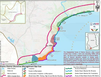
Shama district has an approximately 15 km stretch of coastline which extends from the outlet of the Anankwar River on the south-west and terminates at the barrier beaches and dune systems within the vicinity of Anlo Beach and Epo-ano on the south-east. There is high demand for this shorefront space for commercial uses, recreation, tourism, and as public right of way for access along the coast, as well as access to the shore. Most of these coastal
activities are sources of tax revenue for the district assembly and also provide employment and livelihood opportunities for majority of the district’s people. Nonetheless, in the past few years, development choices in the coastal zone are increasing the risk of people, property and infrastructure to erosion and flooding and resulting in loss of investments and district revenue as well as lives and livelihoods of coastal inhabitants. These threats will only worsen with increasing development pressure and an accelerating rise in sea level due to climate change. As a result, it has become necessary for stakeholders in, and outside of the district, to gain more understanding of the features, functions and characteristics of the coastline and support the development of policies that balance the needs for development and long term
sustainability of the coastal resources that provide district revenue and support livelihoods of its people. Therefore, this bye-law designates the allowable uses and provides decision making criteria for coastal area zones, which are consistent with the Shama Structure Plan.
3.2 Coastal Features
Most of Shama’s shoreline consists of sloping sandy beaches backed by barrier spits, dunes, low and high bluffs, interrupted by sections of rocky shore and headlands which form the partially protected fishing areas of Aboadze, Abuesi, Shama town and Anlo Beach.
3.3 Uses of the Coastal Zone
Uses of the coastal and shorefront space varies from large industrial thermal power
generating facility operated by Volta River Authority (VRA) within the vicinity of Aboadze to the high density residential areas that characterize the shorefront of Aboadze and Abuesi, the low density residential areas north of Aboadze and Abuesi and Shama Town. The
Priority Use Zones
3.4 Statement of Objectives
• Direct development away from high hazard and fast eroding shorelines. • Provide permanent areas for existing traditional economic uses for fishing. • Reduce vulnerability of people and property to coastal erosion and sea level rise. • Reduce risks from natural hazards to life and property in low lying coastal areas and
flood plains.
• Preserve and restore important natural habitats and coastal features that are critical for sustaining the fishing industry and for promoting Shama’s coastline as a recreational destination.
• Ensure the sustainability of fishery related activity through safe, orderly and secure fish-landing sites and small ports.
• Ensure that the impact of coastal zone development on marine environment is reduced and minimized.
• Maintain the viability of water-dependent uses including the movement of people, fish, and cargo by restricting the encroachment of competing uses that may benefit from but do not depend on a waterfront location.
3.5 Definitions
Water dependent uses are uses that can only be conducted on, in, over, or adjacent to the water; each involves, as an integral part of the use, direct access to and use of the water. These uses cannot physically function without direct access to the body of water along which it is proposed. Examples of water dependent uses include: docks, piers, fish processing facilities, canoe/boat repairs, port activities requiring the loading and unloading of vessels. Water dependent uses exclude housing, hotels, motels, restaurants, warehouses,
manufacturing facilities (except for those which receive and quickly process raw materials by ship) etc.
Regeneration is a broad process of reversing physical, economic and social decline in a coastal area
Set back is an area left free of any physical development or modification.
High tide line is the highest point on the shore that is covered by water at high tide. Shoreline protection facilities include breakwaters, groins, bulkheads, jetties, and other structures, the purpose or effect of which is to control or prevent the erosion of coastal features.
The following specific policies and decision-making criteria will apply to all proposed developments or modifications to existing development in the designated zone.
3.6 Conservation, Protection and Recreation Use Zone
The construction of permanent residential buildings and all other alterations of the a)
dunes are generally prohibited, restricted and discouraged unless they demonstrate that such construction or alteration is essential for water-dependent use or other public purpose.
Structures that support water dependent uses and recreation shall be low impact, b)
constructed with temporary materials and of limited loss potential in terms of storm damage.
The Pra estuary and wetland bye-law shall apply to all activities that directly and c)
indirectly impact the estuary and wetland.
Sand extraction is prohibited in this zone. The policy in Shama is to find alternative d)
sources of sand for both commercial and domestic use.
Public access to this zone is a high priority; however it should be of low impact to the e)
natural features and resources.
3.7 Mixed Uses with Fishing, High and Low Density Housing Zone
It is the policy of the Shama district assembly to strengthen the economic base of its a)
fishing communities by encouraging the traditional uses of the waterfront; ensure that the character and integrity of the district’s maritime heritage will be maintained and enhanced; control the uses and intensity of development so as to enhance the value of waterfront land for the intended purpose of retaining and encouraging commercial uses that depend on a waterfront location and support upgrading of existing shorefront infrastructure and regeneration of densely populated fishing settlements.
All permissible settlement shall be set back from the high tide line by 50 times the b)
average rate of erosion of the pockets of sandy beaches in this zone, with a minimum estimated rate of 1.6 meters per year.
A water-dependency test shall be applied in deciding on development proposals for c)
use in this zone. The test for water dependency shall assess both the need of the proposed use for access to the water and the capacity of the proposed water body to satisfy the requirements and absorb the impacts of the proposed use. The test shall emphasize public facilities and commercial land uses which are open to the public, whether free or by payment for services, or it may emphasize maintenance of character of the waterfront by preserving traditional maritime activities.
All development including placement of facilities, structures and alteration of the d)
The highest priority uses of the immediate shore areas within this zone are fish e)
processing, canoe mooring, canoe building and repair, haulage and berthing.
3.8 Waterfront Industrial zone
All permissible large commercial and industrial facilities shall be set back from the a)
high tide line by 70 times the average rate of erosion in the area, with a minimum estimated rate of 1.6 meters per year.
Lateral access to the shore will be permitted in this setback zone, with perpendicular b)
access points designated where practicable.
Highest priority is given to those installations necessary for supporting the movement c)
of goods and materials from shore side facilities to navigable waters, for example the terminus of offshore pipelines or piers and moorings, lay-down areas for items that are being transshipped.
Manufacturing or industrial processing facilities are not considered to be water-d)
dependent and should not be sited in shore areas.
Emergency and environmental management systems must be in place to prevent spills e)
of fuels and materials, and to prevent fire hazards to adjoining residential and commercial areas.
Accident response and clean-up plans and equipment must be in place in cooperation f)
with district emergency response units.
All proposed development on, or alterations to the lower basin of the Anankwar river g)
shall be subject to the provisions of the Anankwar flood hazard prevention and mitigation bye-law.
Where natural coastal features must be disrupted or removed as part of the project h)
design, the developer is required to mitigate this loss by providing permanent equivalent protection or restoration of an area equivalent to that eliminated.
3.9 Tourism and Recreation Zone
a) All permissible developments shall be set back from the high tide line by 50 times the average rate of erosion in the area, with a minimum estimated rate of 1.6 meters per year.
b) Installation of individual shoreline protection facilities is strongly discouraged. c) Temporary installations, equipment and structures should be employed in shoreside
areas to accommodate hotel or facility guests.
d) Lateral access to the shore is preserved by right in tourism zones below the mean high water mark.
e) Perpendicular access is required in site design taking into account the needs of adjoining residences and water dependent activities such as fishing.