The origin of the Woyla Terranes in Sumatra and the Late Mesozoic
evolution of the Sundaland margin
A.J. Barber
SE Asia Research Group, Department of Geology, Royal Holloway, University of London, Egham, Surrey TW20 0EX, UK
Received 5 June 1999; accepted 29 April 2000
Abstract
The Jurassic–Cretaceous Woyla Group of northern Sumatra includes fragments of volcanic arcs and an imbricated oceanic assemblage. The arc rocks are intruded by a granitic batholith and are separated from the original continental margin of Sundaland by the oceanic assemblage. Rocks of the arc assemblage are considered to be underlain by a continental basement because of the occurrence of the intrusive granite and of tin anomalies identified in stream sediments. Quartzose sediments associated with the granite have been correlated with units in the Palaeozoic basement of Sumatra. From these relationships a model has been proposed in which a continental sliver was separated from the margin of Sundaland in the Late Jurassic to Early Cretaceous in an extensional strike-slip faulting regime, producing a short-lived marginal basin. The separated continental fragments have been designated the Sikuleh and Natal microcontinents. In the mid-Cretaceous the extensional regime was succeeded by compression, crushing the continental fragments back against the Sundaland margin, with the destruction of the marginal basin, now represented only by the imbricated oceanic assemblage. Modifications of this scenario are required by subsequent studies. Age-dating of the volcanic assemblage and intrusive granites in the Natal area showed that they formed part of an Eocene–Oligocene volcanic arc and are not relevant to the model. Thick-bedded radiolarian chert and palaeontological studies in the oceanic Woyla Group rocks of the Natal and Padang areas showed that they formed part of a more extensive and long-lived ocean basin which lasted from at least Triassic until mid-Cretaceous. This raised the possibility that the Sikuleh microcontinent might be allochthonous to Sumatra and encouraged plate tectonic reconstructions in which the Sikuleh microcontinent originated on the northern margin of Gondwanaland and migrated northwards across Tethys before colliding with Sundaland. Since these models were proposed, the whole of Sumatra has been mapped and units correlated with the Woyla Group have been recognised throughout western Sumatra. These units are reviewed and the validity of their correlation with the Woyla Group of northern Sumatra is assessed. From this review a revised synthesis for the Late Mesozoic tectonic evolution of the southwestern margin of Sundaland is proposed.q2000 Elsevier Science Ltd. All rights reserved.
1. Introduction
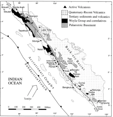
The Indonesian island of Sumatra forms the southwestern margin of Sundaland, the Southeast Asian promontory of the Eurasian continental tectonic plate. At the present time the Indian–Australian plate is being obliquely subducted beneath this margin at a rate of,7 cm/a21. Geologically,
Sumatra consists of a Pre-Tertiary continental basement, overlain by a number of oil and gas-bearing Tertiary sedi-mentary basins (Fig. 1). Towards the southwestern coast of the island the basement is uplifted, exposing Pre-Tertiary rocks in the Barisan Mountains. The Quaternary volcanic arc, with currently active volcanoes, has been constructed on top of this uplifted basement. All the rock units in Suma-tra, Pre-Tertiary basement, Tertiary sediments and Recent volcanics, are cut by the dextral Sumatran strike-slip fault system which extends from NW–SE along the whole length
of the island (Fig. 1). Earthquake activity indicates that movement along the fault, continues to the present day. The Sumatran Fault System is interpreted as the result of oblique subduction of the Indian Ocean Plate beneath Suma-tra (Fitch, 1972).
The concept of the Woyla terranes, was developed from the interpretation of the mapping results of the ‘Integrated Geological Survey of Northern Sumatra’, conducted jointly by the Indonesian Directorate of Mineral Resources (DMR) and the British Geological Survey (BGS) between 1975 and 1980. This survey comprised geological and geochemical reconnaissance mapping of the whole of Sumatra to the north of the equator (Page et al., 1978). Among the results of the survey, a series of 16 geological map sheets at the scale of 1:250,000 with accompanying descriptive booklets, were published by the Indonesian Geological Research and Development Centre (GRDC), Bandung. A summary of the geology and the stratigraphy, with an interpretation of the tectonic development of Sumatra, based on the results of
1367-9120/00/$ - see front matterq2000 Elsevier Science Ltd. All rights reserved. PII: S 1 3 6 7 - 9 1 2 0 ( 0 0 ) 0 0 0 2 4 - 9
www.elsevier.nl/locate/jseaes
this survey, were presented at the 9th Annual Convention of the Indonesian Petroleum Association (Cameron et al., 1980). Geological mapping of the southern part of Sumatra by the Indonesian Geological Survey in collaboration with the United States Geological Survey commenced in the 1970s and was completed by 1995 with the publication of the last of 43 geological map sheets covering the whole of Sumatra.
The DMR/BGS mapping programme commenced in Aceh in northern Sumatra where three tectonostratigraphic units forming the Pre-Tertiary basement were recognised: the Permo-Carboniferous Tapanuli Group; the Permo-Trias-sic Peusangan Group; and the JurasPermo-Trias-sic–Cretaceous Woyla Group. As mapping proceded southwards similar units, covering the same age ranges, were recognised and corre-lated with those of northern Sumatra. Subsequently, units resembling the Woyla Group and with the similar ages have been identified throughout the whole of the western part of Sumatra (Fig. 1). Rock units correlated with the Woyla Group are described from Natal in North Sumatra, at Indar-ung and Siguntur near Padang in West Sumatra, in the
Gumai and Garba Mountains of South Sumatra, and further south near Bandarlampung along the Sunda Strait.
In the north, the Woyla Group and its correlatives lie largely to the southwest of the Sumatran Fault Zone, while to the south, they are only exposed to the northeast of the fault zone. In this contribution, the extent to which these units have been correctly correlated with the Woyla Group, the interpretations which have been proposed for the origin of the Woyla Group and its correlatives, and the validity of the concept of the Woyla terranes, will be discussed and re-examined in the context of the tectonic evolution of the southwestern margin of Sundaland during the Late Mesozoic.
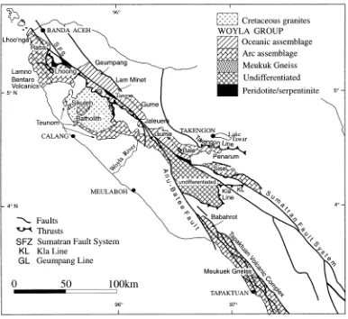
2. Woyla Group in Aceh
Tapaktuan and Takengon 1:250,000 Quadrangle Sheets (Bennett et al., 1981a, b; Cameron et al., 1982, 1983). The descriptions given below, except where specified, are taken largely from the reports which accompany these maps. The Woyla River, from which the Woyla Group was named, is on the Takengon Sheet (Fig. 2).
During the DMR/BGS survey 13 lithostratigraphic units were distinguished in the Woyla Group, as well as a unit of ‘undifferentiated Woyla’. These units generally occur as fault-bounded lenses, distributed on both the northeastern and southwestern sides of the Sumatran Fault, and are elon-gated in a NW–SE direction, parallel to the Sumatran trend. The Woyla Group is also affected by several thrusts; the Geumpang, Takengon and Kla lines. The distribution of these units and the outcrops of the thrusts are shown on Fig. 2.
2.1. Lithological units in the Woyla Group
2.1.1. Tangse Serpentinite (Cahop Serpentinite, Beatang Ultramafic Complex–Takengon Sheet)
Massive serpentinite, representing altered harzburgite,
occurs as lenses along the Sumatran Fault and along the Geumpang Line. The largest of these lenses extends discon-tinuously for 27 km to the northwest of Tangse. Chromite occurs in float in streams near this locality. Here and else-where, serpentinite is locally sheared, schistose, twisted and contorted. Sheared serpentinite may also form the matrix to me´lange (Indrapuri Complex). The me´lange encloses blocks of cumulate gabbro, basalt, red chert and limestones, derived from other members of the Woyla Group. Fossils collected from limestone blocks within the me´lange include: corals: Latoceandra ramosa, Stylina girodi; foraminifera:
Pseudocyclamina sp.; stromatoporoid: Stromatopora japo-nica, indicating a Late Jurassic to Early Cretaceous age. In
the Takengon Quadrangle large blocks of limestone enclosed in sheared serpentinite along the Geumpang Line, contain Late Miocene fossils (Cameron et al., 1983).
2.1.2. Penarum Formation
Outcrops to the northeast of the Sumatran Fault, south of Takengon, and consists of serpentinites, basalts, red cherts with radiolaria and slates. Volcanic rocks are commonly altered to greenschists.
2.1.3. Geumpang Formation (Banda Aceh Sheet); Babahrot Formation (Tapaktuan Sheet)
Outcrops occur, on both sides of the Sumatran Fault to the southeast of Banda Aceh and to the northwest of the Anu-Batee Fault towards Tapaktuan (Fig. 2). Rock types include massive or schistose basic volcanics, pillow basalts, volca-niclastic sandstones and tuffs, commonly epidotised and altered to greenschists or phyllites, and thin grey or black limestones. The phyllites are usually lineated and crenu-lated, indicating multiple deformation. The rocks of the Geumpang Formation are considered to constitute the typi-cal lithologitypi-cal and structural assemblage of the Woyla Group. The Geumpang Formation also includes a massive limestone member, frequently occurring as marble.
The Babahrot Formation, north of Tapaktuan includes serpentinites and talc schists, as well as metagabbroic bodies metamorphosed in the greenschist facies, highly disrupted and sheared into lenses.
2.1.4. Lam Minet Formation (Banda Aceh Sheet); Gume Formation (Takengon Sheet)
Composed of basaltic lavas, commonly epidotised, basal-tic conglomerates and breccias, with volcanic and limestone clasts, but only rarely chert, graded volcaniclastic wackes, radiolarian cherts with manganese oxide veining, rhodonite, and calcareous, manganiferous and carbonaceous slates. A clast of radiolarian chert, embedded in a volcanic conglom-erate with flattened clasts, was collected by Nick Cameron (personal communication, 1999) in the Kreung Baro, Aceh, from a landslip within the outcrop of this formation. This occurrence indicates that volcanic rocks were erupted through ocean floor sediments, perhaps during the formation of a seamount. The formation also includes a recrystallised limestone member.
2.1.5. Jaleuem Formation
Outcrops occur 100 km to the southeast of Banda Aceh, on both sides of the Sumatran Fault. Composed largely of slates, but red cherts occur in float and the unit also includes a limestone member. Rb/Sr dating on 11 samples of slate gave 99^30 Ma (late Early Cretaceous).
2.1.6. Bale Formation
Shown outcropping to the northwest of the Sumatran Fault, and southeast of Takengon. Composed of coloured slates, with minor wackes and cherts, limestones and lime-stone breccias.
2.1.7. Sise Limestone Formation
Consists of massive or bedded limestones, biocalcarenites and calcilutites with fossils: corals: Montlivaltia sp.,
Myrio-pora sp.; foraminifera: Pseudocyclamina sp. indicating a
Late Jurassic to Early Cretaceous age.
2.1.8. Bentaro Volcanic Formation (Banda Aceh Sheet); Tapaktuan Volcanic Formation (Tapaktuan Sheet)
Porphyritic basalts and andesitic basalts with agglomer-ates, intruded by basic dykes. Basaltic vents surrounded by breccias, tuffs and volcaniclastic sediments have been iden-tified near Lam No and north of the Bentaro River on the Banda Aceh Sheet. Chemical analysis of a xenolithic, porphyritic basalt with pyroxene phenocrysts is given in Rock et al. (1982).
The Tapaktuan Volcanic Formation occurs in fault-bounded lenses, within strands of the Anu-Batee Fault Zone, parallel to the west coast of Aceh north of Tapaktuan. It consists of massive epidotised andesites and basalts, commonly porphyritic, and intrusive dykes of a similar composition. An analysis of hornblende microdiorite from this formation is given in Rock et al. (1982). The formation also includes agglomerates, breccias, tuffs, red and purple volcaniclastic sandstones and shales, the latter often as slates, and a limestone member, composed of sparite and calcilutite, all as lenses and much disrupted by faults.
Scattered outcrops of gneiss (Meukuk Gneiss Complex) occur within the Tapaktuan Volcanic Formation in the Bari-san Mountains to the north of Tapaktuan, between strands of the Anu-Batee Fault (Fig. 2). They consist of concordant leucogranodioritic gneiss, with garnet-biotite amphibolite containing garnets up to 8 cm in diameter, and biotite-horn-blende-andesine schist.
2.1.9. Lho’nga Formation
Outcropping to the west of Banda Aceh and composed of grey and coloured slates and phyllites, with interbedded volcaniclastic sandstones, thin limestones and (?)radiolar-ian-bearing siltstones.
2.1.10. Lhoong Formation
Forms a large outcrop to the southwest of the Sumatran Fault and also occurs as roof pendants in the Sikuleh Bath-olith (Bennett et al., 1981b). It consists of basaltic lavas with cherts in the lower part of the sequence, followed by conglomeratic wackes with volcanic and limestone clasts, and subordinate sandstones, siltstones and limestones.
2.1.11. Raba Limestone Formation
Outcrops along the coast and in the Barisan Mountains to the south of Banda Aceh and consists of massive calcarenite and calcilutite and dark thin-bedded cherty limestones and shales. The massive limestone constitutes a ‘reef member’ which is closely associated in the field with the Bentaro Volcanic Formation.
2.1.12. Lamno Limestone Formation
with: corals: Actiastraea minima, Stylosmilia corallina; algae: Clypeina sp., Permocalculus ampullacea,
Litho-codium–Bacinella sp. Boueina sp., Thaumatoporella
porvo-vesiculifera; foraminifera: Pseudocyclammina lituus,
indicating a Late Jurassic to Early Cretaceous age.
2.1.13. Teunom Limestone Formation
Outcropping along the southwestern margin of the Siku-leh Batholith. Composed of massive dark limestones, meta-morphosed and recrystallised along the contact with the granite.
‘Undifferentiated’ Woyla Group rocks are shown on the Calang Quadrangle Sheet in the area to the south of the Sikuleh Batholith in Gunung Paling and as roof pendants within the outcrop of the batholith (Bennett et al., 1981b). In the Explanatory Note to this sheet these rocks are said to resemble the Kluet Formation, low-grade Carboniferous metasediments of the Sumatran basement, which outcrop extensively to the northeast of the Sumatran Fault. The implication here is that these rocks are composed of slates with interbedded quartzose sandstones. They are also reported to include quartzite (Bennett et al., 1981b). Quart-zose rocks are otherwise unknown in the Woyla Group.
Many of the mapping units distinguished in the Woyla Group of Aceh during the DMR/BGS survey are made up of the same rock types but in varying proportions. It is clear that they represent geographical, rather than genuine lithos-tratigraphical units. A different name was given to each distinguishable unit on each map sheet. The actual litholo-gical units within each formation are, on the whole, too small to be represented on the scale of the map.
2.2. Folds and related structures
The rocks of the Woyla Group in Aceh commonly show the effects of intense deformation. The finer grained sedi-mentary and volcaniclastic rock types have been altered to slates and phyllites. Isoclinal folds can be seen wherever bedding lamination can be distinguished, with axial plane cleavage parallel to bedding, and a bedding/cleavage inter-section lineation plunging to the SE. Slaty cleavage may be refolded, into more open folds on sub-horizontal axes and NE-dipping axial planes, with the development of second-ary cleavages, lineations and kink band folds. Larger kilo-meter scale upright folds, up to,7 km, on NW–SE trending
axes and steep axial planes are reported from the Tapaktuan Volcanic Formation, with secondary folds on the scale of
,1–2 km (Cameron et al., 1982).
Massive limestone units in the Woyla Group are less obviously internally deformed, although mylonitised and kink-banded limestones are seen near Banda Aceh. Bedded limestones are sometimes folded on a large scale, as seen in quarries in the Lho’nga Formation between Banda Aceh and Lho’nga (Bennett et al., 1981a). Also in the same area, limestones interbedded with shales show pinch and swell
structures, boudinage and the development of tension gashes normal to the bedding.
On the map scale all the units in the Woyla Group are fault-bounded and form large scale lenses elongated in a NW–SE direction parallel to the Sumatran trend. Internally the units are disrupted by large numbers of faults. Some of these faults are thrusts, along which rock units have been imbricated; others show slickensided surfaces indicating strike-slip movement along faults parallel to, and probably related to the Sumatran Fault System.
2.3. Sikuleh Batholith
The Woyla Group is intruded by granitoids, the largest of which is the Sikuleh Batholith, illustrated on the Banda Aceh and Calang sheets (Bennett et al., 1981a, b). This is an approximately elliptical body (,55×35 km) elongated
in a NW–SE direction (Fig. 2). Around the margins of the batholith, ‘undifferentiated’ Woyla Group rocks and lime-stones of the Teunom Formation, have been altered by contact metamorphism. Roof pendants of metamorphosed Woyla Group rocks, shown as ‘undifferentiated’ on the map, but compared to the Lhoong formation, occur within the batholith (Bennett et al., 1981b). Rocks of the Geumpang Formation are thrust over the northeastern margin of the batholith along the Geumpang Line.
Although no attempt was made during the mapping to delineate the various components of the batholith, descrip-tions show that it is a complex and highly variable body (Bennett et al., 1981b). An ‘older complex’ is distinguished in the northern part of the complex, composed of dark and xenolithic gabbroic and dioritic bodies, migmatitic and intensely veined. The older complex is locally gneissose or sheared. Where foliation is developed, it is parallel to the foliation in the adjacent Geumpang Formation rocks. The ‘younger complex’, which has an intrusive contact against the earlier complex, is a more homogeneous, coarser grained and largely unfoliated, biotite-hornblende grano-diorite, with minor amounts of diorite and pink granite. The granodiorite contains mafic xenoliths and becomes more mafic towards its margins, where it shows ‘flow folia-tion’. The granodiorite and is cut by pegmatites and aplites, the latter being more common adjacent to the contact with the older complex. The batholith shows ‘porphyry-type’ molybdenum mineralisation and tin anomalies of 10–80 ppm have been identified from stream sediment sampling along the contact between the older and younger complex, although no primary tin mineralisation has been recognised (Stephenson et al., 1982). The younger complex has been dated from the mean of K/Ar analyses on two biotites and one hornblende, as 97.7^0.7 Ma (early Late Cretaceous) (Bennett et al., 1981b). The complex is cut by later basic dykes.
2.4. Thrusts
recognised three major thrust zones in northern Sumatra (Fig. 2):
2.4.1. Takengon Line
This thrust has an E–W outcrop to the south of Lake Tawar, where it brings Permo-Triassic rocks of the Peusan-gan Group on top of the Penarum Formation of the Woyla Group along a flat-lying, southward-directed thrust plane. To the west of Takengon, along the continuation of this line, Miocene rocks are thrust over the Woyla Group.
2.4.2. Kla Line
A northwards-directed thrust plane, outcropping to the south of Takengon between the main Sumatran Fault and the Anu-Batee Fault, brings Permo-Carboniferous Tapanuli Group rocks onto ‘undifferentiated’ Woyla Group. Mylo-nites are developed along the thrust plane.
2.4.3. Geumpang Line
In the area to the southeast of Banda Aceh, units of the Woyla Group are separated by an easterly dipping thrust, the Geumpang Line, which outcrops parallel to the Sumatran Fault, and has the same NW–SE trend. Here members of the Woyla Group have been thrust southwestwards over Late Miocene sediments, the northeastern margin of the Sikuleh Batholith and other members of the Woyla Group. Serpen-tinite me´lange, containing a variety of Woyla Group rocks, including blocks of Late Jurassic–Early Cretaceous and Late Miocene limestone, occurs along the fault plane.
Although these thrusts were active during the Tertiary, and affect rocks up to Late Miocene in age, Bennett et al. (1981a, b) and Cameron et al. (1983) consider that they represent more fundamental thrust surfaces in the Pre-Tertiary basement which were reactivated during Late Tertiary or Quaternary movements along the Sumatran Fault Zone. They suggest that serpentinite me´langes, commonly found along the fault and thust planes, were derived from mantle peridotite thrust beneath the margin of Sundaland, which was hydrothermally mobilised and rose diapirically along fault and thrust planes during subsequent fault movements.
2.5. Interpretation of the Woyla Group in Aceh
Cameron et al. (1980) distinguished two lithological assem-blages in the Woyla Group in Aceh: an oceanic (ophiolitic) and an (volcanic) arc assemblage. The distribution of these assemblages is represented on the ‘Simplified Geological Map of Northern Sumatra’ (Stephenson and Aspden, 1982):
2.5.1. Oceanic assemblage
This includes serpentinised harzburgite, metagabbro, mafic to intermediate volcanics, often basaltic and showing pillow structures, volcanic breccias, volcaniclastic sand-stones, red and purple manganiferous slates, red radiolarian cherts. These rock types also occur as blocks in breccio-conglomerates or me´langes.
Units of the oceanic assemblage include the Tangse and Cahop serpentinites, the Beatang Ultramafic Complex and the Penarum, Geumpang, Babahrot, Lam Minet, Jaleueum and Bale formations. All these units lie to the northeast of the Geumpang Line, and almost entirely to the northeast of the Sumatran Fault Zone (Fig. 2). Unfortunately, no age-diagnostic radiolaria have yet been obtained from the many occurrences of bedded (?radiolarian) chert which occur among these units, so that their age(s) has not been estab-lished directly. Limestone blocks in serpentinous me´lange along the Geumpang Line, which yielded Late Jurassic to Early Cretaceous fossils, were ascribed to the Geumpang Formation (Cameron et al., 1983), but are more reasonably regarded as derived tectonically from underlying limestone units during the thrust movements, in the same way as Late Miocene blocks which are also included in the me´lange.
The oceanic assemblage of the Woyla Group in Aceh shows an intimate mixture of ocean floor materials from different structural levels, from mantle to abyssal sediments, variously internally deformed, separated by faults, often identified as thrusts and arranged in a random order. These are the characteristic features of an accretionary complex, where ocean floor materials are imbricated against the hanging wall of a subduction zone. Garnetiferous amphibolites of the Meukuk Gneiss in the Tapaktuan Volca-nic Formation suggest that gabbroic rocks of the oceaVolca-nic assemblage were subducted into the mantle, before being returned tectonically to the surface.
2.5.2. Arc assemblage
This is typified by the Bentaro and Tapaktuan Volcanic Formations, and is composed of porphyritic andesite, occur-ring as vents near Bentaro, basalt lavas, intrusive dykes, agglomerates, breccias, volcaniclastic sandstones and shales. These igneous rocks are closely associated in the field with massive or bedded limestones, which commonly contain volcanic clasts or are interbedded with volcaniclas-tic units. These limestone units include the Lho’nga, Raba, Lamno, Lhoong, and Teunom Limestone formations, as well as the limestone lenses which occur within the Tapak-tuan Volcanic Formation. Most of the units belonging to the arc assemblage lie to the southwest of the Geumpang Line and the Sumatran Fault. The only exception to this distribu-tion, according to the geological map of Stephenson and Aspden (1982), is the Sise Limestone Formation, outcrop-ping to northeast of the Sumatran Fault, to the the south of Takengon (Fig. 2). This anomaly can be removed by rever-sing displacement along the Sumatran Fault. The Lamno and Sise limestones and the ‘Geumpang’ limestone blocks within the Indrapuri Complex all contain fossils which indi-cate a Late Jurassic–Early Cretaceous age.
fringing reefs represented by the massive limestones. In this model, massive limestones were eroded to form limestone breccias, and detritus was transported into deeper water to form bedded limestones. Cameron et al. (1980) put forward evidence which indicated that the volcanic arc was built up on a sliver of continental crust. The observation of a volca-nic breccia containing radiolarian chert clasts in the Lam Minet Formation indicates that volcanic rocks were some-times extruded through ocean floor sediments.
2.6. The marginal sea model
Cameron et al. (1980), noting the absence of a mid-Cretaceous magmatic arc in the eastern part of northern Sumatra, rejected the interpretation that the oceanic assem-blage of the Woyla Group represents the accreted remnants of older segments of the ‘Indian Ocean’ in an earlier stage of the subduction process which continues today offshore southwest Sumatra. Instead, they interpreted the oceanic assemblage as the remnants of a short-lived marginal ocea-nic basin, developed along the southwestern margin of Sundaland in a phase of extreme oblique subduction and active strike-slip faulting, with the formation of a pull-apart basin and then oceanic crust.
The marginal basin was formed in Late Jurassic–Early Cretaceous times by the separation of a continental sliver from the western margin of Sundaland, in the same way as the Andaman Sea or the Gulf of California are being forming at the present time (Cameron et al., 1980, their Fig. 4a). The separated continental sliver is now represented by the Bentaro Volcanic Arc and the Sikuleh Batholith. Also associated with the batholith are ‘undifferentiated’ Woyla metasediments which resemble the Carboniferous Kluet Formation of the Sumatran basement, and tin anomalies. All these features are taken as evidence that the arc volcanics overlie continental crust. On the Tectonic Map of Northern Sumatra the basement underlying the arc assemblage is described as the Sikuleh Continental Fragment (Aspden et al., 1982).
Subsequently, as a result of continuing subduction outboard of the continental fragment and transpressional strike-slip movement, this small marginal ocean basin was compressed, crushing both the floor of the marginal basin and the detached continental fragment against the Sunda-land margin. The Takengon and Kra lines represent the thrust surfaces along which the materials of the marginal basin were thrust beneath the continental margin of Sunda-land. The suture, representing the site of this disappeared marginal basin, coincides approximately with the line of the present day Sumatran Fault. Also, as the result of compres-sion, the continental fragment and its overlying arc were thrust beneath the oceanic assemblage along the Geumpang Line (Cameron et al., 1980).
Although there is no direct evidence for the age of the ocean floor materials, and the age of the volcanic arc is established only from the palaeontological dating of its fringing reefs, all these events are considered to have
occurred between the Late Jurassic and Late Cretaceous. It is suggested that rifting of the continental margin and the formation of the volcanic arc occurred in the Late Juras-sic and the opening of the marginal basin took place in the Early Cretaceous. The intrusion of the Sikuleh Batholith into both the oceanic and the arc assemblages shows that the closure of the basin and the compression of the arc against the continental margin was completed by Late Cretaceous times (Cameron et al., 1980).
Woyla Group rocks which took part in these events are now sliced into lenticular slivers by more recent movements along the Sumatran Fault (Cameron et al., 1980). In the field it is difficult to distinguish between thrust faults which were formed by the imbrication of the units during subduction, and later strike-slip faults related to the Sumatran Fault System unless slickensides are present. It is impossible to distinguish between strike-slip faults formed as the result of oblique subduction and those due to later fault movements (Wajzer et al., 1991).
As has already been suggested, the anomalous position of the massive limestones of the Sise Limestone Formation, which now lie on the northeastern side of the main strand of the Sumatran Fault, may be the result of movements along the fault. The Sise Limestone Formation and the Lamno Limestone Formation near Banda Aceh, contain similar fossil assemblages and are of the same age. Rever-sing the dextral movement along the fault for a distance of
,200 km would bring the Sise and Lamno formations into
juxtaposition. This order of movement along the Sumatran Fault is compatible with the evidence from regional consid-erations, with a 460 km movement in the Andaman Sea reducing southwards to a displacement of only a few kilo-metres in the Sunda Strait (Curray, 1989; McCaffrey, 1991). Strike-slip fault movements along the Sumatran Fault System are also considered to have reactivated fundamental thrusts in the basement along the Takengon, Kla and Geum-pang lines, as Neogene rocks are affected by this movement, in transpressional zones along strands of the fault system (Cameron et al., 1980).
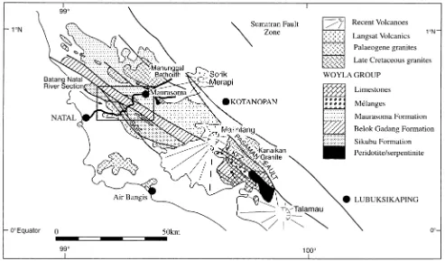
3. Woyla Group in Natal
exposed in the valley of the Batang Natal, both in the river section and in the parallel road section, which both cut across the strike (Fig. 4). The main outcrop of the Woyla Group is separated from a smaller outcrop in the Pasaman inlier to the south by Malintang Volcano (Fig. 3).
3.1. DMR/BGS report
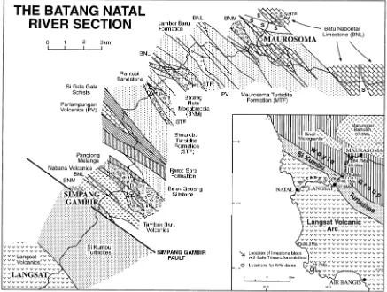
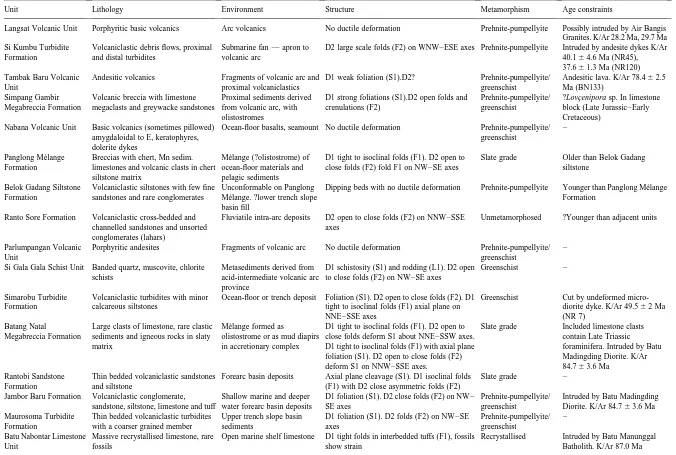
In the DMR/BGS report of the Lubuksikaping Quadran-gle (Rock et al., 1983) lithological units in the Batang Natal section were classified, from NE–SW, into three tions: the Maurosoma, Belok Gadang and the Sikubu forma-tions (Fig. 3).
The Maurasoma Formation outcrops in the upstream part of the section and in its tributary the Aik Soma. Thicknesses of the rock units in this section were measured perpendicu-lar to the strike for a distance of 5.5 km (Rock et al., 1983). The rock types include cleaved argillaceous units, shale or slate, which may include calcareous concretions, laminated siltstones, and gritty sandstones showing sedimentary struc-tures, indicating younging in a downstream direction, massive limestones, sometimes forming limestone pinna-cles, epidotic volcanic breccias and volcaniclastic sand-stones, chloritic greenschists and muscovite-chlorite quartz schists. A 10 m ‘conglomerate’ (? me´lange) at the upstream end of the section, with elongated clasts of greens-chist in a chloritic matrix, is probably of tectonic origin, formed in a fault or a shear zone (Rock et al., 1983).
The Belok Gadang Formation outcrops in the central part of the section and is composed of sandstones, sometimes calcareous, and argillaceous rocks, often cleaved and containing bands and lenses of chert. The chert is radiolar-ian, but no identifiable radiolaria have so far been recovered which could be used to date the sequence. Outcrops in the type locality of Belok Gadang, a tributary of the Batang Natal, show basaltic pillow lavas, with white clay interbeds and manganese-rich horizons with braunite, resembling the ‘umbers’, described from the Troodos Ophiolite of Cyprus (Robertson, 1975). Analysis shows that the pillow basalts are spilites (Rock et al., 1982, 1983). In the type locality basalts are overlain by red, bedded cherts, but again no identifiable radiolaria have been recovered.
The Sikubu Formation, outcropping in the lower part of the Batang Natal section, is composed of massive volcani-clastic metagreywackes, with thin shale interbeds. The sandstones show very well-developed sedimentary struc-tures, including graded bedding, flame structures and convo-lutions, typical of turbidites. Massive porphyritic andesitic dykes and lava flows, with distinctive pyroxene pheno-crysts, are intruded into or interbedded with the sediments in the lower part of the section. Fragments of porphyritic andesite, identical in composition to the dykes and lavas, occur as clasts in the sandstones.
Pasaman River where they are composed mainly of harzbur-gite with minor dunite pods, pyroxenite dykes, disseminated chromite and rare chromite pods. Some of the peridotite is foliated, containing orthopyroxenes enclosed in augen. Coarse plagioclase-hornblende rocks, found as boulders in the float, represent metasomatised gabbro pegmatite which formed dykes in the peridotite. The peridotite is variably serpentinised, and in shear zones may be completely altered to serpentine and talc. Smaller bodies of serpentinite, with chromite pods, outcrop at the upper end of the Batang Natal section near Maurasoma (Figs. 3 and 4) where they form spectacular serpentinite breccias faulted against slates and limestones of the Maurasoma Formation. Serpentinite also occurs as xenoliths in granite in the Aik Soma.
3.2. Langsat Volcanic Formation
Porphyritic, net-veined and amygdaloidal basic lavas of the Langsat Formation, associated with agglomerates, outcrop at the southwestern end of the Batang Natal section (Rock et al., 1983) (Fig. 3). The lavas are melanocratic but contain leucocratic xenoliths. The basic rocks are highly porphyritic, with abundant clinopyroxene phenocrysts, but show very little plagioclase in thin section; the dominant feldspar in the ground mass being orthoclase. Analyses
show that these lavas have a highly unusual chemical composition with low SiO2and high MgO contents (Rock
et al., 1982, 1983). Exceptionally high contents of Cr, Ni and Co are correlated with the abundance of augite. The absence of hypersthene, the lack of plagioclase and the presence of orthoclase, together with the overall chemical composition, shows that these lavas are absarokites (basic shoshonites) (Rock et al., 1983).
3.3. Late Mesozoic intrusions
amphibolite. Limestones in the same area are converted to skarns near the contact with the granite.
A second granitoid, the Kanaikan intrusion, is intruded into the Woyla Group in the Pasaman area (Fig. 3). This body is composed of coarse granodiorite and leucogranite cut by microgranitic and granophyric dykes. The intrusion lies within the Kanaikan Fault Zone, a strand of the main Sumatran Fault, and is much dissected by faults and deformed to cataclasite along shear zones.
3.4. Palaeogene intrusions
Granitic rocks form scattered outcrops in headlands near Air Bangis, along the coast to the south of Natal (Fig. 3). A large area inland of these outcrops on the Lubuksikaping Sheet is also shown as occupied by granitoid. This inland outcrop is largely conjectural, as the interpretation is based on aerial photographic interpretation, and much of the area is covered by cloud on the photographs used in the inter-pretation (Rock et al., 1983). The coastal outcrops are composed of hornblende-biotite adamellites, leucogranites and granites, cut by microgranitic and microdioritic dykes. These intrusions are shown on the Lubuksikaping Sheet as of Eocene–Oligocene age. However, Rock et al. (1983) in their report, speculate that these intrusions might be of Late Cretaceous age, analogous to the Sikuleh intrusion which ocupies a similar position with respect to the Woyla Group in Aceh.
3.5. Age constraints in the Natal area
Age constraints for the Woyla Group in the Natal area are provided by a limestone sample from the Batang Kanaikan in the Pasaman inlier which yielded a colonial organism, closely resembling the samples of Lovc¸enipora described and illustrated by Yancey and Alif (1977) from the Indarung area, near Padang, and considered to be of Late Jurassic to Early Cretaceous age (IGS/British Museum Sample No.TC/ J1/R1101B- Rock et al., 1983). A minimum age for the Woyla Group is provided by the Manunggal Batholith, dated at 87.0 Ma (Late Cretaceous) (Kanao et al., 1971, quoted in Rock et al., 1983), which intrudes limestones and serpentinites at the northwest end of the Batang Natal section.
3.6. Interpretation — the marginal sea model
The model developed by the DMR/BGS mapping team to explain the origin and tectonic environment of the Woyla Group in Aceh was extended southwards, with minor modi-fications, to account for the distribution of similar rock assemblages of Jurassic to Cretaceous age outcropping in the Natal area of North Sumatra (Rock et al., 1983).
Rock et al. (1983) interpreted the Maurosoma Formation at the northeastern end of the section, which includes turbi-dites and massive limestones, as shelf sediments of the Sundaland continental margin. The Belok Gadang
Forma-tion, with pillow basalts and cherts, was interpreted as the deformed floor of the marginal basin, and the Sikubu Formation in the southwest as the erosion products of a volcanic arc. The arc itself is represented by the the Langsat Volcanics which outcrop at the southwest end of the Batang Natal section (Rock et al., 1983) (Figs. 3 and 4). As in Aceh, the arc was considered to overlie continental basement and constitutes a microcontinental block, identified in the ‘Tectonic Map of Northern Sumatra’ as the Natal Continen-tal Fragment (Aspden et al., 1982). The Air Bangis grani-toids, considered to be intrusive into the Langsat Volcanics, although this relationship is not actually observed, are regarded as evidence that the arc is underlain by continental crust. Again, using the age constraints provided by the occurrence of Lovc¸enipora in Woyla Group rocks in the Pasaman inlier and the age of intrusion of the Manunggal Batholith, Rock et al. (1983, their Fig. 8) postulate that between Late Jurassic and Early Cretaceous time, a pull-apart rift developed into a short-lived marginal basin along the margin of Sundaland, which was then compressed and destroyed by the Late Cretaceous. Rock et al. (1983) acknowledged that if the Cretaceous age ascribed to the Air Bangis granitoids was not correct, then the marginal sea model was invalid and the arc and its underlying conti-nental basement might constitute a terrane allochthonous to Sumatra. In the key to the Lubuksikaping Map Sheet the Air Bangis granitoids are shown as of Late Cretaceous/Palaeo-gene age.
3.7. Wajzer study
The Batang Natal section was mapped in detail by Marek Wajzer from the University of London, in a follow-up study to the Northern Sumatra Survey, in collaboration with BGS and with the assistance of Syarif Hidayat and Suharsono of GRDC (Wajzer et al., 1991). The mapping was supported by petrographic, geochemical and radiometric studies. Wajzer et al. (1991) found that the Woyla Group was not neatly divisible into three distinct lithological units, but that the same recognisable lithologies were repeated many times throughout the section, apparently in a random fashion (Fig. 4). Wajzer et al. (1991) distinguished 16 lithostratigra-phical units in the Natal section. Correlation with the mapping units recognised by Rock et al. (1983) is shown in Table 1. Detailed accounts of the lithological units are given in Table 2. Many of the lithologies are similar to rock types described from the Woyla Group in Aceh, and by Rock et al. (1983), with the addition of several outcrops of me´lange, composed of blocks in a fine grained matrix, decribed as ‘megabreccia’ in Table 2 and Fig. 4. One impor-tant feature of the clastic units in the Woyla Group of the Natal area is that they are almost completely devoid of quartz, suggesting that they have an entirely oceanic, rather than a continental origin (Wajzer et al., 1991).
dating. A further specimen of Lovc¸enipora was obtained from a limestone block in the Simpang Gambir Megabreccia near the southwestern end of the Batang Natal section, and a Late Triassic foraminifera was found in a limestone clast in the Batang Natal Megabreccia in the central part of the section. Diorite intruded into the Jambor Baru and Batang Natal Megabreccia Formations at Batu Madingding gave a K/Ar age of 84.7^3.6 Ma and an andesite in the Tambak Baru Volcanic unit, interpreted as a fragment of a volcanic arc, gave 78.4^2.5 Ma. Both these lavas and the intrusions are of Late Cretaceous age. Andesite dykes intruded into the Si Kumbu Turbidite Formation (i.e. Sikubu Formation of Rock et al., 1983), and regarded as contemporaneous with sedimentation of this unit, gave K/Ar ages of 40.1^4.6 and 37.6^1.3 Ma (Late Eocene) (Wajzer et al., 1991). Samples collected from the Air Bangis granitoids and analysed by Wajzer gave K/Ar ages of 29.7^1.6 and 28.2^1.2 Ma (Late Oligocene) (Wajzer et al., 1991) raising the possibility that the Cretaceous age for these granitoids suggested in the DMR/BGS report (Rock et al., 1983) was incorrect.
Wajzer et al. (1991) also studied the structure in detail (Table 2). Most units in the Natal River section show some degree of internal deformation. Deformation ranges from broad open folding of the bedding in the Si Kumbu and Rante Sore formations, to isoclinal folding and penetrative slaty cleavage in fine grained units and mylonitic foliation in the Si Gala Gala Schists. Clasts in breccia formations (me´langes) are flattened and elongated parallel to the clea-vage in the matrix. Several units are affected by multiple
deformation, with the earlier isoclinal folds and schistosity folded by more open folds, and the development of second-ary cleavages and lineations. Some units such as the Rante Sore Formation are completely unmetamorphosed, while metabasites show pumpelleyite and actinolite, and schists contain coarse white micas, indicating metamorphism up to greenschist facies. There is no systematic progression either in intensity of deformation or in grade of metamorphism through the section, the units appearing to be randomly arranged (Wajzer et al., 1991).
Each of the units distinguished in the Woyla Group in the Natal River section is separated from adjacent units by stee-ply dipping or vertical faults. In addition units are frequently disrupted internally by faults, often every few metres. Some of the fault planes show vertical slickensides, indicating normal or reverse movement, while others show horizontal slickensides, indicating strike-slip movement (Wajzer et al., 1991).
3.10. Interpretation — the allochthonous terrane model
The Batang Natal section was reinterpreted by Wajzer et al. (1991). They pointed to the absence of any significant amount of quartz in the volcaniclastic sediments or any continental clastic material in the massive limestones of the Maurosoma Formation, and suggested that these depos-its were of oceanic, rather than of continental margin origin. They concluded, from the extensive deposits of bedded radi-olarian chert and associated manganiferous argillites, that the oceanic deposits represented accreted fragments of the floor of a major ocean basin, rather than the floor of a restricted marginal sea. As in Aceh, in the absence radio-metric ages for the pillow basalts, or of diagnostic radiolaria in the chert, there is no direct evidence of the age of forma-tion of the ocean floor. Wajzer et al. (1991) suggest that the volcanic units represent seamounts or fragments of volcanic arcs, and that limestone blocks in the me´langes represent fragments of the collapsed carbonate cappings to these seamounts, or fringing reefs to the arcs. Foraminifera in a limestone block in one of these me´langes suggest that a seamount was constructed on ocean floor which was at least as old as Triassic, and that therefore the ocean basin was already in existence in the early Mesozoic.
Wajzer et al. (1991), on the basis of interbedded lava flows and the occurrence of fragments of andesite in the conglomerates, recognisably derived from the Langsat Volcanics, accepted the interpretation of Rock et al. (1983) that the Si Kumbu Turbidite Formation (their Sikubu Formation) was contemporaneous with the Langsat Volca-nics, and that the volcanics and volcaniclastic turbidites represent a volcanic arc. Andesite dykes intruded into the Si Kumbu Formation, of similar composition to the lavas, gave radiometric dates of 37.6 and 40.1 Ma (Late Eocene). As has already been reported, Rock et al. (1983), following the marginal sea model from Aceh, suggested that the Air Bangis granitoids, which are presumed to be intruded into Table 1
Correlation of formations in the Woyla Group of the Natal area from Rock et al. (1983) with lithotectonic units defined by Wajzer et al. (1991)a
Rock et al. (1983) Wajzer et al. (1991)
1. Langsat Volcanic Formation 1. Langsat Volcanic Formation 2. Sikubu Formation 2. Si Kumbu Turbidite Formation
3. Tambak Baru Volcanic Unit 4. Simpang Gambir Megabreccia
Formation
3. Belok Gadang Formation 5. Nabana Volcanic Unit
6. Belok Gadang Siltstone Formation 7. Panglong Me´lange Formation 8. Ranto Sore Formation Volcanics in both the Belok
Gadang and Maurasoma Formations
9. Parlampungan Volcanic Unit
4. Maurasoma Formation 10. Si Gala Gala Schist Formation Schistose Member 11. Simarobu Turbidite Formation 12. Batang Natal Megabreccia Unit 13. Rantobi Sandstone Formation 14. Jambor Baru Formation 15. Maurasoma Turbidite Formation Massive limestones in both the
Belok Gadang and Maurasoma Formations
16. Batu Nabontar Limestone Unit
a
A.J.
Lithology, environmental setting, structure, metamorphic grade and age constraints for units in the Batang Natal section (in order upstream from W to E, see Fig. 4) (from Wajzer et al., 1991)a
Unit Lithology Environment Structure Metamorphism Age constraints
Langsat Volcanic Unit Porphyritic basic volcanics Arc volcanics No ductile deformation Prehnite-pumpellyite Possibly intruded by Air Bangis Granites. K/Ar 28.2 Ma, 29.7 Ma Si Kumbu Turbidite
Formation
Volcaniclastic debris flows, proximal and distal turbidites
Submarine fan — apron to volcanic arc
D2 large scale folds (F2) on WNW–ESE axes Prehnite-pumpellyite Intruded by andesite dykes K/Ar 40.1^4.6 Ma (NR45), 37.6^1.3 Ma (NR120) Tambak Baru Volcanic
Unit
Andesitic volcanics Fragments of volcanic arc and proximal volcaniclastics
D1 weak foliation (S1).D2? Prehnite-pumpellyite/ greenschist
Andesitic lava. K/Ar 78.4^2.5 Ma (BN133)
D1 strong foliations (S1).D2 open folds and crenulations (F2)
Nabana Volcanic Unit Basic volcanics (sometimes pillowed) amygdaloidal to E, keratophyres, dolerite dykes
Ocean-floor basalts, seamount No ductile deformation Prehnite-pumpellyite/ greenschist
–
Panglong Me´lange Formation
Breccias with chert, Mn sedim. limestones and volcanic clasts in chert siltstone matrix
Me´lange (?olistostrome) of ocean-floor materials and pelagic sediments
D1 tight to isoclinal folds (F1). D2 open to close folds (F2) fold F1 on NW–SE axes
Slate grade Older than Belok Gadang siltstone
Belok Gadang Siltstone Formation
Volcaniclastic siltstones with few fine sandstones and rare conglomerates
Unconformable on Panglong Me´lange. ?lower trench slope basin fill
Dipping beds with no ductile deformation Prehnite-pumpellyite Younger than Panglong Me´lange Formation
Ranto Sore Formation Volcaniclastic cross-bedded and channelled sandstones and unsorted conglomerates (lahars)
Fluviatile intra-arc deposits D2 open to close folds (F2) on NNW–SSE axes
Unmetamorphosed ?Younger than adjacent units
Parlumpangan Volcanic Unit
Porphyritic andesites Fragments of volcanic arc No ductile deformation Prehnite-pumpellyite/ greenschist
– Si Gala Gala Schist Unit Banded quartz, muscovite, chlorite
schists
Metasediments derived from acid-intermediate volcanic arc province
D1 schistosity (S1) and rodding (L1). D2 open to close folds (F2) on NW–SE axes
Greenschist –
Simarobu Turbidite Formation
Volcaniclastic turbidites with minor calcareous siltstones
Ocean-floor or trench deposit Foliation (S1). D2 open to close folds (F2). D1 tight to isoclinal folds (F1) axial plane on NNE–SSE axes
Greenschist Cut by undeformed micro-diorite dyke. K/Ar 49.5^2 Ma (NR 7)
Batang Natal
Megabreccia Formation
Large clasts of limestone, rare clastic sediments and igneous rocks in slaty matrix
Me´lange formed as
olistostrome or as mud diapirs in accretionary complex
D1 tight to isoclinal folds (F1). D2 open to close folds deform S1 about NNE–SSW axes. D1 tight to isoclinal folds (F1) with axial plane foliation (S1). D2 open to close folds (F2) deform S1 on NNW–SSE axes.
Slate grade Included limestone clasts contain Late Triassic
Forearc basin deposits Axial plane cleavage (S1). D1 isoclinal folds (F1) with D2 close asymmetric folds (F2)
Slate grade – Jambor Baru Formation Volcaniclastic conglomerate,
sandstone, siltstone, limestone and tuff
Shallow marine and deeper water forearc basin deposits
D1 foliation (S1). D2 close folds (F2) on NW– SE axes with a coarser grained member
Upper trench slope basin sediments
D1 foliation (S1). D2 folds (F2) on NW–SE axes
Open marine shelf limestone D1 tight folds in interbedded tuffs (F1), fossils show strain
Recrystallised Intruded by Batu Manunggal Batholith. K/Ar 87.0 Ma
a All units are cut by numerous faults and thrusts. Vertical faults often show horizontal slickensides indicating wrench fault movements. *K/Ar age of Manunggal Batholith from Kanao et al. (1971). All
the Langsat Volcanics, were of Late Cretaceous age, and therefore analogous to the Sikuleh Batholith. However, as already pointed out, they acknowledged that if this correla-tion was incorrect then the Aceh marginal /sea model could not be applied to the Natal area. In the event, the Air Bangis granitoids gave ages of 28 and 29 Ma, indicating that the Langsat Arc was formed during Late Eocene–Early Oligo-cene times (Wajzer et al., 1991).
Wajzer et al. (1991) were impressed by the evidence of strike slip faulting throughout the Natal section, and in parti-cular by the major Simpang Gambir Fault, which separates the Si Kumbu Turbidites (Sikubu Formation of Rock et al., 1983) and the Langsat Volcanics from the Belok Gadang ocean floor assemblage (Fig. 4). They therefore suggested that the Natal Continental Fragment was an allochthonous terrane, which had reached its present position by strike-slip movement from a location further to the south along the Sumatran continental margin. The possibility of an allochthonous origin for the Natal Continental Fragment was also considered by Rock et al. (1983), but rejected in favour of the interpretation previously reached for the tectonic evolution of the Woyla Group in Aceh (Cameron et al., 1980). Although as already pointed out they acknowl-edged that if the Late Cretaceous age for the Air Bangis granitoids was incorrect, then an allochthonous origin was probable. Wajzer et al. (1991) reversing the correlation, suggested that if the Natal Microcontinental Fragment is an allochthonous terrane, then it is possible that the Sikuleh Microcontinental Fragment although of a different age, is also allochthonous.
4. Other units in Sumatra correlated with the Woyla Group
Outcrops of rock units with similar lithologies to those of the Woyla Group or which were formed within the same Jurassic–Cretaceous age range have been mapped through-out western Sumatra (Fig. 1). Many of these through-outcrops have been correlated with the Woyla Group of northern Sumatra by previous authors.
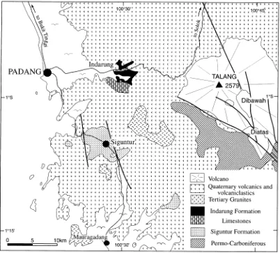
4.1. Indarung formation
Small outcrops of the Mesozoic Indarung Formation occur near Padang in West Sumatra. These rocks were mapped and described by Yancey and Alif (1977) and were correlated with the Woyla Group of Aceh by Cameron et al. (1980). Outcrops occur 15 km east of Padang in road, river and quarry sections near Indarung, where they are surrounded and overlain by Neogene and Quaternary volca-nic and volcavolca-niclastic rocks (Fig. 5). The area of outcrop is included on the Padang, Solok and Painan Quadrangle Sheets (Kastowo and Leo, 1973; Silitonga and Kastowo, 1975; Rosidi et al., 1976). These rocks have been mapped more recently by McCarthy et al. (2001).
Yancey and Alif (1977) described rocks exposed in the
Lubuk Peraku River, the Ngalau Quarry, the Karang Putih Quarry and adjacent river sections near Indarung. Rock types in these outcrops are basic volcanics, which may include pillow lava, volcanic breccia, tuff, volcaniclastic sediments, radiolarian chert and massive or bedded lime-stones. The basic rocks are sometimes deformed and meta-morphosed to form greenschists. On the other hand, the limestones and cherts are essentially undeformed, although disharmonic folding and small scale thrusts in the chert and gentle folds in the limestone are seen in the quarries, and the limestones may be recrystallised (McCarthy et al., 2001).
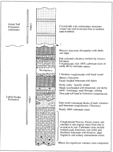
A well exposed section of limestone and tuff occurs in the river section of the Lubuk Peraku and in the road above the river (Yancey and Alif, 1977; McCarthy et al., 2001). Bedding in the limestones has a steep, but variable dip to the southwest, and the section youngs in the same direction. A measured columnar section of these outcrops from McCarthy et al. (2001) is given as Fig. 6. The lower part of the section, described as the Lubuk Peraku Limestone, is a limestone breccia, which includes volcanic clasts near the base and is interbedded with thin tuff bands near the top. The breccia is overlain by a few metres of thin-bedded lime-stones and shelly marls and then by thicker bedded and more massive limestones, some oolitic. Near the top of the section a limestone conglomerate, eroded into the underlying lime-stone with basal scours, provides clear evidence of way-up. Above the breccia there is a break in the outcrop, until outcrops further downstream and in the road section above expose a calcareous vitreous crystal tuff, the Golok Tuff. Although the contact between the breccia and the tuff is not exposed, McCarthy et al. (2001) regard this section as an essentially continuous stratigraphic sequence, as tuff layers occur within the limestone breccia and tuffs within the overlying Golok Tuff unit are calcareous.
In the Ngalau Quarry, near Indarung, McCarthy et al. (2001) collected samples from a 15 m section of bedded chert for radiolarian determination. In the Karang Putih Quarry, 1 km to the south of Indarung, excavated in an isolated hill for the manufacture of cement, lenses of chert are associated with massive limestone. McCarthy et al. (2001) report that the limestone in this quarry is completely recrystallised, possibly due to the effects of a granitic intru-sion which occurs a short distance to the south (Fig. 5). They suggest that relationships between limestone and chert in this quarry are tectonic. In an interpretative cross section they show the cherts and limestones imbricated together along low angle thrusts (McCarthy et al., 2001).
Rock units in the Indarung area are well dated from fossil and radiometric age determinations. Radiolaria from chert in the Ngalau Quarry belong to the Transhsuum
hisui-koyense Zone, of Aalenian, early Middle Jurassic age
Molluscan shell fragments, pellets, calcareous algae, stromatoporoids and scleractinian corals are common components of the limestones. Among the fossils identified were the (?) stromatoporoids Actostroma and Lovc¸enipora. The former is considered to be restricted to the Late Juras-sic, while the latter is diagnostic of the Late Jurassic to Early Cretaceous. A K/Ar age date of 105^3 Ma (Albian, mid-Cretaceous) is reported from the Golok Tuff in the Lubuk Peraku by Koning and Aulia (1985, from a Caltex Pacific Indonesia internal report).
Pillow lavas and cherts of the Indarung Formation have been equated with the oceanic assemblage of the Woyla Group of Aceh and with the Belok Gadang Formation of the Natal area (Cameron et al., 1980; Rock et al., 1983). Where these rocks are imbricated, deformed and altered to greenschists they may be interpreted, as is the case in Aceh and Natal, as materials accreted from a subducted ocean floor. The recent recognition of Middle Jurassic radiolaria in the cherts (McCarthy et al., 2001) shows that part of this ocean floor was of Jurassic age. The volcanic breccias tuffs and volcaniclastic sandstones of the Indarung Formation are interpreted as the products of seamount volcanism, and the
massive limestone with its Late Jurassic–Early Cretaceous fossil fauna is interpreted as part of a fringing reef formed around the seamount (McCarthy et al., 2001). During subduction the seamount with its carbonate cap collided with already accreted ocean floor materials, and the whole assemblage was imbricated to form the present complex.
4.2. Siguntur formation
similar age to the limestones at Indarung. However, abun-dant terrigenous quartz in the clastic sediments, notably absent from the Woyla Group in Natal and the rock units at Indarung, suggests that the sediments of the Siguntur Formation had a continental provenance and were deposited in a continental margin environment.
Although these rocks are deformed, with the develop-ment of slaty cleavage, there is no suggestion in the descriptions that these rocks have been imbricated or can be interpreted as part of an accretionary complex (Rosidi et al., 1976). In the Siguntur Formation we are dealing for the first time in this account with continentally-derived
sedi-ments which were deposited on the Sundaland continental margin.
4.3. Suilak, Tabir, Asai, Peneta and Rawas formations in central Sumatra
quartz clasts. The limestones contain Loftulisa and
Hydro-corallinae of Cretaceous age (Tobler, 1922, reported in
Rosidi et al., 1976). The volcanic rocks are altered ande-sites, dacites and bedded tuffs with clasts of augite, horn-blende, chlorite and glass. These rocks are the product of Andean arc volcanism on the margin of Sundaland.
Sixty kilometers to the east of Siulak and to the northeast of the Sumatran Fault Zone, in the Batang Tabir, are outcrops of red conglomerates, sandstones and tuffs of the Tabir Formation. Clasts in the conglomerates include quart-zite, and andesitic fragments derived from the adjacent Palaeozoic rocks. The presence of Ostrea is taken to indi-cate a Mesozoic, possibly Jurassic age (Tobler, 1922, reported in Rosidi et al., 1976). Continuous with these outcrops and extending southeastwards to the south of Bangko, and also to the northeast of the Sumatran Fault, are large outcrops of Mesozoic rocks of the Asai, Peneta and Rawas formations (Kusnama et al., 1993; Suwarna et al., 1994), (Fig. 1). Rock types include quartz sandstones, siltstones, shales, limestones and tuffs. The Rawas Forma-tion also includes andesite-basalt lava flows, tuffs and volca-niclastic sandstones. Clasts in conglomeratic units in these sediments are derived from the local Palaeozoic basement. Sandstone units show turbiditic characteristics. Argillac-eous units have a slaty cleavage striking NW–SE. Fossils,
including corals and ammonites, especially from the lime-stone members, show that these sediments range in age from Middle Jurassic to Early Cretaceous (Suwarna et al., 1994). All these sediments, although subject to later deforma-tion, were evidently deposited in situ on the Sundaland continental basement. Pulunggono and Cameron (1984) suggested that these units were deposited in a foreland basin, but a forearc environment, related to an Andean volcanic arc represented by the volcanics lava flows and tuffs in the Rawas and Tabir Formation is more probable.
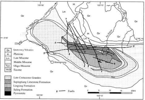
4.4. Gumai Mountains
Pre-Tertiary rocks form an inlier to the northeast of the Sumatran Fault Zone in the Gumai Mountains of South Sumatra, where they occupy the core of an anticline, surrounded by Tertiary sediments and volcanics (Fig. 7). These Pre-Tertiary rocks are described as the Saling, Lings-ing and SepLings-ingtiang formations (Gafoer et al., 1992).
lavas are interpreted as tholeiites of oceanic affinity (Gafoer et al., 1992). The Lingsing Formation in the southern part of the inlier, contains similar igneous rocks, interbedded with claystone, siltstone, sandstone, calcilutite and chert. The Saling and Lingsing formations are therefore considered to be contemporaneous. Since the tholeiitic basalts are asso-ciated with serpentinised ultrabasic pyroxenites and cherts, the whole assemblage is regarded as ophiolitic sequence of ocean floor origin. Although the rocks are highly deformed and folded it is not clear from the descriptions whether they are imbricated to form an accretionary complex (Gafoer et al., 1992). The strike of bedding and cleavage in the sedi-ments is said to be N–S. The the mapped E–W contact between the Saling and the Lingsing formations is therefore presumably tectonic (Fig. 7).
The Saling and Lingsing formations are overlain discor-dantly by the Sepingtiang Limestone Formation (Fig. 7). This is composed of massive, brecciated and bedded lime-stones, containing the coral Calamophylliopsis crassa (Late Jurassic), the foraminifera Pseudotexturariella, small Cuneolina (Early Cretaceous) and Orbitolina sp.
(mid-Cretaceous). The contact between the Sepingtiang Lime-stone and the underlying units is considered to be tectonic (Gafoer et al., 1992).
All of these units are cut by granitic intrusions, which by analogy with similar dated granitoids further south in the Garba Mountains, are regarded as of Late Cretaceous age (Gafoer et al., 1992). The rocks of the inlier and the surrounding Tertiary rocks are also cut by NW–SE trending faults, some showing strike-slip displacements (Fig. 7), and are evidently related to the Sumatran Fault System, the main strands of which lie some 25 km to the southwest.
As already noted, Gafoer et al. (1992) interpreted the igneous rocks of the Saling Formation as ocean floor basalts, on the basis of their tholeiitic composition and their associa-tion in the field with serpentinites and cherts. However, the presence of andesites, the amygdaloidal and porphyritic textures, together with association of the volcanics with the massive Sepintiang Limestone, suggest that the Saling Formation also includes part of a volcanic arc. The descrip-tion of the Saling Formadescrip-tion closely resembles that of the Bentaro Volcanic Formation of Aceh (Bennett et al., 1981a) and the Nabana Volcanic and Parlumpangan units of the Batang Natal (Wajzer et al., 1991). The Early Cretaceous age shows that the Saling Volcanic Arc was active contem-poraneously with the Bentaro Arc of Aceh.
The Sepingtiang Limestone may be interpreted in the same way as the limestones in Aceh, as a fringing reef surrounding a volcanic arc. Fossil evidence of the Late Jurassic to mid-Cretaceous age of the Sepintiang Limestone Formation means that it can be correlated directly with the Lamno, Teunom and Sise Limestone formations of Aceh (Bennett et al., 1981a; Cameron et al., 1983), the Batu Nabontar limestones in the Batang Natal section (Wajzer et al., 1991) and the Lubuk Peraku limestones at Indarung (Yancey and Alif, 1977).
The Lingsing Formation, composed of siltstones, shales and cherts, has been interpreted as deposited in a bathyal environment (van Bemmelen, 1949; Gafoer et al., 1992). The presence of lavas interbedded with clastic deposits, suggests that the Lingsing Formation represents more distal flows, volcaniclastic sediments and clastic carbonates derived from the arc extending out onto an ocean floor, represented by the bedded cherts. These rocks resemble clastic units in the Lho’nga Formation of Aceh (Bennett et al., 1981a) and the Belok Gadang Siltstone and Rantobi Sandstone formations of Natal (Wajzer et al., 1991).
4.5. Garba Mountains
The Garba Mountains form an inlier of pre-Tertiary rocks, about 100 km to the southeast of the Gumai Moun-tains and also northeast of the Sumatran Fault Zone (Fig. 1). The inlier is shown on the GRDC Baturaja Quadrangle Sheet (Gafoer et al., 1994) (Fig. 8). The oldest unit, which outcrops on both eastern and western sides of the inlier, is the Tarap Formation, composed of phyllite, schist, slate, minor quartzite and marble, metamorphosed in the greens-chist facies. The age of the Tarap Formation is unknown, but it is presumed to be older than the adjacent, but unphosed Garba Formation, and is interpreted as the metamor-phosed Palaeozoic basement of Sumatra (Gafoer et al., 1994). Outcrops of the Tarap Formation occur within the Garba Formation and in large areas to the east and west. The relationships between the metamorphic Tarap Formation and the Garba Formation, as shown on the map, are not clear (Gafoer et al., 1994) (Fig. 8). The eastern contacts are faulted and possibly thrust. If the Tarap is part of the metamorphosed Palaeozoic basement of Sumatra, it may represent the western margin of the Sundaland continent, thrust westwards over accreted ocean floor materials repre-sented by the other units in the inlier. The present distribu-tion of these metamorphic rocks could be due to the disruption of the thrust sheet by faulting and erosion.
(Fig. 8). Two fold phases are recognised in the Garba Formation, an earlier phase of E–W folds and a later phase of NE–SW folds (Gafoer et al., 1994). Neither the cherts nor the limestones have so far yielded age-diagnostic fossils.
Both the Tarap and the Garba formations are intruded by the Garba Pluton, a composite body in which an older component has been dated at 115^4 and 102^3 Ma (mid-Cretaceous) and a younger component at 79^1.3 and 89.3^1.7 Ma (Late Cretaceous). Rock units within the inlier are cut and bounded by NW–SE trending faults. Although these faults are parallel to the Sumatran Fault System they do not appear to affect significantly the Tertiary rocks and must be largely of Pre-Tertiary age.
The Garba Formation has been compared to the Woyla Group of Natal (Gafoer et al., 1994) and certainly litholo-gical descriptions of this formation and its Insu and Situlan-glang members, correspond very well with those from Aceh and the Batang Natal section. The basaltic and andesitic lavas of the Garba Formation correspond with those of the Bentaro Arc, and may similarly be interpreted as part of a volcanic arc sequence. Limestone blocks within the me´lange may represent fragments of fringing reefs or the collapsed carbonate cappings of seamounts, the latter now
represented by volcanics in the Garba Formation, as has been suggested for the Natal and Indarung areas (Wajzer et al. 1991; McCarthy et al., 2001). Descriptions of the me´langes of the Insu Member of the Garba Formation (Gafoer et al., 1994) are identical to those from Natal (Wajzer et al., 1991). The interlayering of the Insu Member with lavas, chert and me´lange (Gafoer et al., 1994) suggests that these rocks are deformed and imbricated in the same way as the Woyla Group in the Batang Natal section, and similarly represent an accretionary complex formed by subduction of an ocean floor. It may be that some of the low grade metamorphic schists mapped within the Insu Member as Tarap Formation, are part of this accretionary complex, as metamorphic rocks, up to greens-chist facies, are incorporated in the accretionary complex at Natal.
The mid- to Late Cretaceous Garba Pluton (115–79 Ma) intrudes both the Tarap and the Garba formations, so that the accretion of the Garba Formation to the margin of Sunda-land, if the Tarap is correctly identified as Palaeozoic base-ment, took place before the mid-Cretaceous. The age of the younger component of the Garba Pluton is comparable to that of the Sikuleh Batholith in Aceh (98 Ma) and the Manunggal Batholith (87 Ma) in Natal.
4.6. Bandarlampung area
Pre-Tertiary rocks occur as scattered outcrops among Tertiary and Quaternary volcanic and volcaniclastic sedi-ments in the area between Kotaagung and Bandarlampung in Lampung Province, southern Sumatra (Amin et al., 1994; Andi Mangga et al., 1994) (Fig. 9). Outcrops towards the northeast of the area consist of pelitic, calcareous, quartzose or graphitic schists and sericitic quartzites, with intercalated gneiss, marble and amphibolites, described as the Gunung-kasih Complex. Within the complex there is a tendency for outcrops to the northeast to be composed of orthogneiss, while those to the southwest are composed of metasedi-ments. The strike of the foliation in the schists trends gener-ally NW–SE but the schistosity is folded about E–W axes and refolded by NW–SE trending upright folds and then by variably oriented kink band folds. These rocks are suggested to be equivalent to the Tarap Formation of Garba and meta-morphic equivalents of the Palaeozoic Tapanuli Group in Aceh and the Kuantan Formation in the Padang area (Amin et al., 1994; Andi Mangga et al., 1994).
Outcrops of unmetamorphosed rocks, identified as the Menanga Formation, lie largely to the the southwest of
the Gunungkasih Complex (Fig. 9). These consist of tuffac-eous and calcartuffac-eous claystones, sandstones and shales with intercalated radiolarian-bearing cherts, manganese nodules and coral limestones and rare porphyritic basalt. The sand-stones contain clasts of glassy andesite and lithic fragments of andesite, quartz-diorite and quartzite. The cherts have not so far yielded diagnostic radiolaria, but Zwierzycki (1932, confirmed in Andi Mangga et al., 1994), reports the occur-rence of Orbitolina sp. of Aptian-Albian (mid-Cretaceous) age from limestones in the Menanga river section. The bedding strikes NW–SE with dips of 358–608to the north-east. The rocks are folded and cut by faults, with slicken-sides indicating reverse movement.
The contact between the Gunungkasih Complex and the Menanga Formation in Gunung Kasih is obscured, due to rice cultivation, and in Teluk Ratai is at present inaccessible as it lies within a Naval Base (Fig. 9). However, the latter contact in the Menanga River was described by Zwierzycki (1932) as occupied by a ‘friction breccia’. On the GRDC maps Amin et al. (1994) and Andi Mangga et al. (1994) show both these contacts as thrusts (Fig. 9).