Open Geospatial Consortium Inc.
Date: 9 September 2008
Reference number of this OpenGIS® Project Document: OGC 07-074
Version:1.2
Category: OpenGIS® Interface Standard
Editor: Marwa Mabrouk, ESRI
Contributors: Tom Bychowski, NavTeq Jonathan Williams, Hutchison 3G Harry Niedzwiadek, Image Matters Yaser Bishr, Image Matters Jean-Francois Gaillet, Webraska Neil Crisp, Intergraph Will Wilbrink, MapInfo Mike Horhammer, Oracle Greg Roy, Autodesk Serge Margoulies, Ionic Gil Fuchs, Tele Atlas Geoffery Hendrey, Telcontar
OpenGIS
Location Services (OpenLS): Core Services
[Part 1-Directory Service, Part 2-Gateway Service, Part 3-Location Utility Service (Geocoder/Reverse Geocoder), Part 4-Presentation Service, Part 5-Route Service]
Copyright © 2002-2008 Open Geospatial Consortium, Inc. All Rights Reserved. To obtain additional rights of use, visit http://www.opengeospatial.org/legal/.
Warning
This document is an OGC Standard. The authors welcome feedback. This document represents an official position of the OGC and of the OGC Technical Committee. It is subject to change without notice and may be referred to as an OGC Standard. Recipients of this document are invited to submit, with their comments, notification of any relevant patent rights of which they are aware and to provide supporting documentation.
Document type: OpenGIS Implementation Standard Document subtype: Interface
License Agreement
Permission is hereby granted by the Open Geospatial Consortium, Inc. ("Licensor"), free of charge and subject to the terms set forth below, to any person obtaining a copy of this Intellectual Property and any associated documentation, to deal in the Intellectual Property without restriction (except as set forth below), including without limitation the rights to implement, use, copy, modify, merge, publish, distribute, and/or sublicense copies of the Intellectual Property, and to permit persons to whom the Intellectual Property is furnished to do so, provided that all copyright notices on the intellectual property are retained intact and that each person to whom the Intellectual Property is furnished agrees to the terms of this Agreement.
1 If you modify the Intellectual Property, all copies of the modified Intellectual Property must include, in addition to the above copyright notice, a notice that the Intellectual Property includes modifications that have not been approved or adopted by LICENSOR.
2 THIS LICENSE IS A COPYRIGHT LICENSE ONLY, AND DOES NOT CONVEY ANY RIGHTS UNDER ANY PATENTS THAT MAY BE IN FORCE ANYWHERE IN THE WORLD.
3 THE INTELLECTUAL PROPERTY IS PROVIDED "AS IS", WITHOUT WARRANTY OF ANY KIND,
EXPRESS OR IMPLIED, INCLUDING BUT NOT LIMITED TO THE WARRANTIES OF MERCHANTABILITY, FITNESS FOR A PARTICULAR PURPOSE, AND NONINFRINGEMENT OF THIRD PARTY RIGHTS. THE COPYRIGHT HOLDER OR HOLDERS INCLUDED IN THIS NOTICE DO NOT WARRANT THAT THE FUNCTIONS CONTAINED IN THE INTELLECTUAL PROPERTY WILL MEET YOUR REQUIREMENTS OR THAT THE OPERATION OF THE INTELLECTUAL PROPERTY WILL BE UNINTERRUPTED OR ERROR FREE. ANY USE OF THE INTELLECTUAL PROPERTY SHALL BE MADE ENTIRELY AT THE USER’S OWN RISK. IN NO EVENT SHALL THE COPYRIGHT HOLDER OR ANY CONTRIBUTOR OF
INTELLECTUAL PROPERTY RIGHTS TO THE INTELLECTUAL PROPERTY BE LIABLE FOR ANY CLAIM, OR ANY DIRECT, SPECIAL, INDIRECT OR CONSEQUENTIAL DAMAGES, OR ANY DAMAGES
WHATSOEVER RESULTING FROM ANY ALLEGED INFRINGEMENT OR ANY LOSS OF USE, DATA OR PROFITS, WHETHER IN AN ACTION OF CONTRACT, NEGLIGENCE OR UNDER ANY OTHER LEGAL THEORY, ARISING OUT OF OR IN CONNECTION WITH THE IMPLEMENTATION, USE,
COMMERCIALIZATION OR PERFORMANCE OF THIS INTELLECTUAL PROPERTY.
4 This license is effective until terminated. You may terminate it at any time by destroying the Intellectual Property together with all copies in any form. The license will also terminate if you fail to comply with any term or condition of this Agreement. Except as provided in the following sentence, no such termination of this license shall require the termination of any third party end-user sublicense to the Intellectual Property which is in force as of the date of notice of such termination. In addition, should the Intellectual Property, or the operation of the Intellectual Property, infringe, or in LICENSOR’s sole opinion be likely to infringe, any patent, copyright, trademark or other right of a third party, you agree that LICENSOR, in its sole discretion, may terminate this license without any compensation or liability to you, your licensees or any other party. You agree upon termination of any kind to destroy or cause to be destroyed the Intellectual Property together with all copies in any form, whether held by you or by any third party.
5 Except as contained in this notice, the name of LICENSOR or of any other holder of a copyright in all or part of the Intellectual Property shall not be used in advertising or otherwise to promote the sale, use or other dealings in this Intellectual Property without prior written authorization of LICENSOR or such copyright holder. LICENSOR is and shall at all times be the sole entity that may authorize you or any third party to use certification marks, trademarks or other special designations to indicate compliance with any LICENSOR standards or specifications.
6 This Agreement is governed by the laws of the Commonwealth of Massachusetts. The application to this Agreement of the United Nations Convention on Contracts for the International Sale of Goods is hereby expressly excluded. In the event any provision of this Agreement shall be deemed unenforceable, void or invalid, such provision shall be modified so as to make it valid and enforceable, and as so modified the entire Agreement shall remain in full force and effect. No decision, action or inaction by LICENSOR shall be construed to be a waiver of any rights or remedies available to it.
Table of Contents
1 Scope ... 1
2 Conformance ... 1
3 Normative references ... 1
4 Relationship to Other Standards Activities ... 2
5 Terms and definitions ... 3
6 Symbols (and abbreviated terms) ... 5
7 Top-Level Architecture ... 5
8 OpenLS Core Services ... 6
8.1 Part 1: Directory Service ... 7
8.1.1 Pinpoint Directory Service ... 8
8.1.2 Proximity Directory Service ... 8
8.1.3 Use Cases ... 8
8.1.4 Request and Response Parameters for Directory Service ... 9
8.2 Part 2: Gateway Service ... 13
8.2.1 Use cases ... 13
8.2.2 A Location Request Use Case ... 14
8.2.3 Request Parameters ... 14
8.3 Part 3: Location Utility Service (Geocode/ Reverse Geocode) ... 19
8.3.1 Use Cases ... 19
8.3.2 Request and Response Parameters ... 20
8.4 Part 4: Presentation Service ... 23
8.4.2 Use Cases ... 26
8.4.3 Request and Response Parameters ... 26
8.4.4 Request and Response Pairs for Use Cases ... 32
8.5 Part 5: Route Service ... 36
8.5.2 Use Cases ... 36
8.5.3 Request and Response Parameters ... 37
9 OpenLS Information Model ... 43
10 General Use Cases ... 44
11 Architecture Details ... 45
12 General Features ... 46
13 Conformance Requirements and Procedures ... 46
14 Future Work ... 47
14.1 OpenLS 1.0 ... 47
14.2 OpenLS 1.1 ... 47
Annex A.1: OpenGIS Location Services (OpenLS) Core Services Schema,
XML/S Profile (Normative) ... 49
Annex A.2: OpenGIS Location Services (OpenLS) Requirements (Informative) ... 134
1 Requirements ... 134
1.1 Terminology ... 134
1.2 General Requirements ... 134
1.2.1 Usage Scenarios ... 135
1.2.2 Design Guidelines ... 135
1.2.3 Detailed Requirements ... 136
1.3 Interface Envelop and Encoding Requirements ... 138
1.3.1 Key Concepts ... 138
1.3.2 General Usage Pattern ... 138
1.3.3 Assumptions ... 139
1.3.4 General Requirements ... 139
1.3.5 Encoding Requirements ... 140
1.3.6 Request Requirements ... 142
1.3.7 Response Requirements ... 143
1.3.8 HTTP Transaction Protocol Requirements ... 144
1.4 Abstract Data Type Requirements ... 145
1.4.1 Address ADT ... 146
1.4.7 Route Instructions List ADT ... 147
1.4.8 Route ADT ... 147
1.5 Service Requirements ... 147
1.5.1 Directory Service requirements ... 147
1.5.2 Gateway service requirements ... 149
1.5.3 Location Utility service requirements ... 149
1.5.3.1 Geocode Service ... 149
1.5.3.2 Reverse Geocode Service ... 150
1.5.4 Presentation Service ... 150
1.5.5 Route Service Requirements ... 151
Annex A.3: OpenGIS Location Services (OpenLS) Schema, OpenLS 1.1 Changes (Informative) ... 152
1. Add geometry to route instruction element. ... 152
2. Explain usage of “lang” attribute on XLS element. ... 152
3. Allow more than two street intersections. ... 153
4. Directory Request – SortCriteria / POI properties. ... 153
5. Editorial changes ... 155
6. Add expectedEndTime to route. ... 155
8. Specify preferred distance units in directory responses ... 156
9. Schema validation fix ... 157
10. Clarify street encodings ... 157
11. Documentation change to clarify Street Attributes ... 158
12. Correlate a route map with a route instruction. ... 158
13. Remove SearchArea from ReverseGeocodeRequest ... 162
14. Remove devType from RequestHeader ... 162
15. Correct/update document submitters ... 162
Annex A.4: OpenGIS Location Services (OpenLS) Schema, SOAP Profile (Informative) ... 163
i.
Preface
This OpenGIS Interface Standard defines OpenGIS Location Services (OpenLS): Core Services, Parts 1-5, which consists of the composite set of basic services comprising the OpenLS Platform. This platform is also referred to as the GeoMobility Server (GMS), an open location services platform.
The first version of this standard was produced immediately following the OpenLS 1/1.1 testbed initiatives, October 2001 – October 2002, and reflects lessons learned and the results of these efforts. It also includes enhancements and fixes made subsequent to the testbed efforts by an ad hoc work group consisting of the sponsors of this standard.
ii.
Submitting organizations
This Standard was submitted to OGC by the following organizations: Autodesk, Canada
ESRI, USA
Image Matters, USA
Intergraph IntelliWhere, Australia MapInfo, USA
Navigation Technologies, USA Oracle, USA
Sun Microsystems, USA Webraska, France Tele Atlas, USA Telcontar, USA
iii.
Document Contributor Contact Points
All questions regarding this submission should be directed to the editors.
CONTACT COMPANY ADDRESS
Leesburg, VA 20175
Tom Bychowski (Co-Author)
Navigation Technologies 222 Merchandise Mart Plaza Suite 200
Chicago, IL. 60654 USA
Neil Crisp (Co-Author) IntelliWhere Division, Intergraph Corporation.
Floor 3, 299 Coronation Drive, Milton Queensland 4064.
Australia.
Jean-François Gaillet (Co-Author)
Webraska 22 Avenue Guynemer
BP 107
Maisons-Laffitte Cedex
France
Marwa Mabrouk (Editor, Co-Author)
ESRI Inc. 380 New York st. Redlands CA 92373, USA
Harry Niedzwiadek (Co-Author)
Image Matters 105 S. King Street
Leesburg, VA 20175
Jonathan Williams (Co-Author)
Hutchison3G, UK Limited Star House, 20 Grenfell Road,
Maidenhead, SL6 1EH, United Kingdom
Will Wilbrink (Co-Author) MapInfo MapInfo Corp 26 Wellington St East Suite 500
Toronto, Ontario M5E1S2
iv.
Revision history
Date Release Author Paragraph modified Description
Oct. 2001 – Oct. 2002
various various N/A Most of the content for this specification came from the final specifications developed under the OpenLS 1/1.1 initiatives, namely:
OpenLS Reference Architecture: Draft Implementation Specification, Version 0.2.0, November 2002, OpenGIS Discussion Paper 02-089.
OpenLS Route Determination Service: Draft Implementation Specification, Version 0.8.0, November 2002, OpenGIS Discussion Paper 02-090.
OpenLS Presentation Service: Draft Implementation Specification, Version 0.1.8, November 2002, OpenGIS Discussion Paper 02-091.
Draft Implementation Specification, Version 0.6.0, November 2002, OpenGIS Discussion Paper 02-092.
OpenLS Gateway Service: Draft Implementation Specification, Version 0.2.0, November 2002, OpenGIS Discussion Paper 02-093.
OpenLS Directory Service: Draft Implementation Specification, Version 0.8.0, November 2002, OpenGIS Discussion Paper 02-094.
This document supersedes these specifications.
All specs were combined into one document. The schemas were simplified. The full profile of the Route
Determination Service becomes the new Navigation Service. The basic profile of the former Route Determination Service becomes the new Route Service. Abstract types are removed from the new Route Service and Navigation Service to be consistent with other OpenLS Core Services. Issues were added.
Dec 19, outstanding issues inline, and 2) Added notation to title page to reflect draft state of the document.
April 18, 2003
0.3, 0.4, 0.5 MM, HAN, WW, PD, GR, OR
Various Schemas updated to GML 3.0 geometry. Schemas updated to OMA MLP 3.0. Numerous inconsistencies were fixed, clarifications were added and schema bugs fixed on the basis of comments from MapInfo and Autodesk.
December 22, 2004
1.1 MM Various As specified in Annex 3
v.
Changes to the OpenGIS
Abstract Specification
Foreword
The information in this document was substantially derived from the OpenLS 1/1.1 testbed initiatives, public comment, and implementation experience.
Attention is drawn to the possibility that some of the elements of this document may be the subject of patent rights. The Open Geospatial Consortium Inc. shall not be held responsible for identifying any or all such patent rights.
OpenGIS
Location Services (OpenLS): Core Services
[Part 1-Directory Service, Part 2-Gateway Service, Part
3-Location Utility Service (Geocoder/Reverse Geocoder), Part
4-Presentation Service, Part 5-Route Service]
8 Scope
This OpenGIS Interface Standard describes OpenGIS Location Services (OpernLS): Core Services, Parts 1-5, also known as the GeoMobility Server (GMS), an open platform for location-based application services. It also outlines the scope and relationship of OpenLS with respect to other specifications and standardization activities.
The primary objective of OpenLS is to define access to the Core Services and Abstract Data Types (ADT) that comprise the GeoMobility Server, an open location services platform.
9 Conformance
The framework, concepts, and methodology for testing, and the criteria to be achieved to claim conformance, are specified in ISO 19105: Geographic information —
Conformance and Testing. See section 20 concerning the requirements and procedures for OpenLS Conformance.
10 Normative references
The following normative documents contain provisions, which through reference in this document constitute provisions of this architecture. For dated references, subsequent amendments to these publications or revisions of any of these publications do not apply. However, parties to agreements based on this document are encouraged to investigate the possibility of applying the most recent editions of the normative documents indicated below. For undated references, the latest edition of the documents applies.
Abstract Specification Topic 0: Overview, OpenGIS document 04-084. Available [Online] :< http://portal.opengeospatial.org/files/?artifact_id=7560>
OpenGIS® Geography Markup Language (GML), Version 3.1.1, OpenGIS Encoding Standard. Available [Online]: <
http://portal.opengeospatial.org/files/?artifact_id=4700>.
OpenGIS® Location Services (OpenLS): Part 6: Navigation Service, Version 0.5, April 18, 2003, OpenGIS RFC 08-028r7. Available [Online]: <
http://portal.opengeospatial.org/files/?artifact_id=28493>.
Common Coordinate Reference Systems and Coordinate Transformations. OGC Project Document 05-095r1 and 05-094r1. Available [Online]: < http://portal.opengeospatial.org/files/?artifact_id=13204>.
OGC Units of Measure Use and Definition Recommendations. OGC Recommendation Paper. OGC Project Document 02-007r4. Available [Online]: <http://portal.opengeospatial.org/files/?artifact_id=11498>.
OpenGIS® Simple Features Specification for SQL 1.2. OGC Interface and Encoding Standard. Available [Online]: <
http://portal.opengeospatial.org/files/?artifact_id=18241>.
XML Linking Language (XLink) Version 1.0. W3C Recommendation (27 June 2001). Available [Online]: <http://www.w3.org/TR/xlink/>
Namespaces in XML. W3C Recommendation (14 January 1999). Available [Online]: <http://www.w3.org/TR/1999/REC-xml-names-19990114/> XML Schema Part 1: Structures. W3C Recommendation (2 May 2001). Available [Online]: <http://www.w3.org/TR/xmlschema-1/>
XML Schema Part 2: Datatypes. W3C Recommendation (2 May 2001). Available [Online]: <http://www.w3.org/TR/xmlschema-2/>
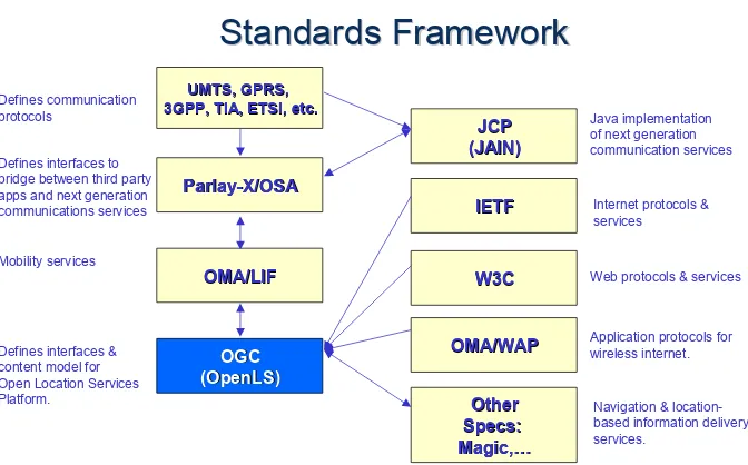
11 Relationship to Other Standards Activities
UMTS, GPRS,
UMTS, GPRS,
3GPP, TIA, ETSI, etc.
3GPP, TIA, ETSI, etc.
Parlay
Defines interfaces to bridge between third party apps and next generation communications services
Defines interfaces & content model for of next generation communication services
Web protocols & services Application protocols for wireless internet.
IETF
IETF Internet protocols & services
Navigation & location-based information delivery services.
Figure 1. Standards Framework
12 Terms and definitions
For the purposes of this document, the following terms and definitions apply.
5.1 Abstract Data Type (ADT)
The basic information construct used by the GeoMobility Server and associated Core Services. Consists of well-known data types and structures for location information. Defined as application schemas that are encoded in XML for Location Services (XLS).
5.2 Area of Interest (AOI)
A user defined area (represented by a bounding box, circle or polygon). Often used as a filter in a query.
5.3 (OpenLS) Core Services
The basic services that comprise the open service platform (GeoMobility Server) defined under OpenLS.
5.4 Directory Service
5.5 Gateway Service
A network-accessible service that fetches the position of a known mobile terminal from the network. This interface is modeled after the Mobile Location Protocol (MLP),
Standard Location Immediate Service, specified in OMA 3.0 (see Open Mobile Alliance).
5.6 Geocoder Service
A network-accessible service that transforms a description of a location, such as a place name, street address or postal code, into a normalized description of the location with a Point geometry (see OGC GML Encoding Standard for OGC geometry).
5.7 GeoMobility Server
The open service platform comprising the Core Services developed under the OGC OpenLS initiatives.
5.8 Location-Based Service (LBS)
A wireless-IP service that uses geographic information to serve a mobile user. Any application service that exploits the position of a mobile terminal.
5.9 Navigation Service
An enhanced version of the Route Service, which is a network-accessible service that determines travel routes and navigation information between two or more points. (This service is documented under separate cover, see section 10.)
5.10 Point of Interest (POI)
A location (with a fixed position) where one can find a place, product or service,
typically identified by name rather than by address and characterized by type, which may be used as a reference point or a target in a location based service request, e.g., as the destination of a route.
5.11 Presentation (Map Portrayal) Service
A network-accessible service that portrays a map made up of a base map derived from any geospatial data and a set of ADT’s as overlays.
5.12 Reverse Geocoder Service
A network-accessible service that transforms a given position into a normalized
description of a feature location (Address with Point), where the address may be defined as a street address, intersection address, place name or postal code.
5.13 Route Service
A network-accessible service that determines travel routes and navigation information between two or more points.
5.14 XML for Location Services (XLS)
13 Symbols (and abbreviated terms)
The following symbols and abbreviated terms are used in this document. ADT Abstract Data Type
API Application Program Interface
GMLC Gateway Mobile Location Center GMS GeoMobility Server
LBS Location Based Service
LIF Location Interoperability Forum
MLP Mobile Location Protocol MPC Mobile Positioning Center
OGC Open Geospatial Consortium
OMA Open Mobile Alliance OSA Open Service Architecture
XLS XML for Location Services
XML eXtended Markup Language
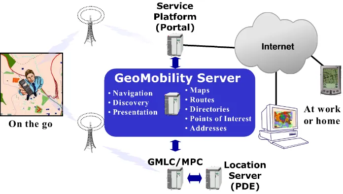
14 Top-Level Architecture
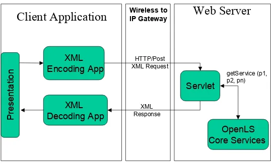
Figure 2 shows how the concept GeoMobility Server relates to the other elements of an LBS architecture. The GeoMobility server is an element offering basic functions on which location-based applications are built (the OpenLS Core Services). This server uses open interfaces to access network location capacity (provided through a GMLC, for instance) and provides a set of interfaces allowing applications hosted on this server, or on another server, to access the OpenLS Core Services (see definition of Core Services in section 15).
The GeoMobility Server also provides content such as maps, routes, addresses, points of interest, traffic, etc. It can also access other local content databases via the Internet.
In summary, the GeoMobility Server contains:
The OpenLS Information Model, consisting of ADTs;
Possibly, a set of local applications build upon the Core Services and accessing them through OpenLS interfaces;
Content such as map data, points of interest, routes, and so on used by the Core Services. This content can also be hosted on other servers and accessed through the Internet; and
Possibly other supporting functions for personalization, context management, billing, logging, etc.
Figure 2. Role of the GeoMobility Server
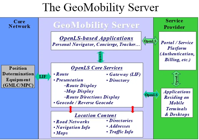
15 OpenLS Core Services
The GeoMobility Server
Portal / Service Platform (Authentication,
Billing, etc.)
•Route
•Presentation
–Route Displa y
–Map Displa y
–Route Directions Display
•Geocode / Reverse Geocode LIF Personal Navigator, Concierge, Tracker…
O
•Road Net works
•Navigation Info
Figure 3. The GeoMobility Server
Note: It is not necessary to specify a Coordinate Reference System for Point geometries that are used by these services because the default for all coordinates used by the GeoMobility Server is WGS 84. The coordinate conventions are as follows:
- Default Coordinate Reference System - WGS 84 (srsName=EPSG4326);
- Coordinate Order - Latitude, Longitude;
- Value Type - Decimal Degrees;
- Latitude Sign is +90 at North Pole to -90 at South Pole;
- Longitude Sign is -180 west from Greenwich at the International Dateline to +180 east from Greenwich at the International Dateline.
15.1 Part 1: Directory Service
in the request when the subscriber is seeking the nearest place, product or service, or if they desire a place, product or service at a specific location or within a specific area. The position may be the current Mobile Terminal position, as determined through the
Gateway Service, or a remote position determined in some other manner. The directory type may also be specified (e.g. yellow pages, restaurant guide, etc). Given the
formulated request, the Directory Service searches the appropriate online directory to fulfill the request, finding the nearest or specific place, product or service, depending on the search criteria. The service returns one or more responses to the query (with locations and complete descriptions of the place, product, or service, depending upon directory content), where the responses are in ranked order based upon the search criteria.
15.1.1 Pinpoint Directory Service
Provides subscribers with access to an online directory to find the location of a specific
place, product or service. This service is independent of subscriber location (e.g., the subscriber may wish to ‘pinpoint’ a place in a distant country).
15.1.2 Proximity Directory Service
Provides subscribers with access to an online directory to find the nearest place, product or service.
From the Usage Scenarios below, it seems unnecessary to separate these usages into two services, when they are simply special cases of the same underlying Directory Service request.
The examples below will illustrate that there are two simple cases for finding a particular point of interest that roughly correspond to the Pinpoint and Proximity requests:
1. By some property of the Point of Interest (e.g., unique identifier, name, description, phone number, absolute location)
2. By its location relative to some other point of interest (e.g., Nearest to me, within some distance of a specified entity, within some defined boundary).
Any of these or combinations of these may be made using the combined Directory Services request which is specified below.
15.1.3 Use Cases
The user of the Directory Service wishes to locate a particular Place, Product or Service. The user may constrain the request by specifying parameters that filter out candidate places/products/services according to some identifier, attribute, or location.
15.1.3.1 Use Case 1
Constraining the request by identifier amounts to a Pinpoint White Pages query: “Where is the Red Dragon Chinese Restaurant?”
15.1.3.2 Use Case 2
Constraining the request just by attribute amounts to a normal Yellow Pages query: “Where are the Chinese Restaurants?”
15.1.3.3 Use Case 3
Constraining the request by location relative to a given location amounts to a Proximity query: “Where is the nearest Chinese Restaurant to my hotel?”
15.1.3.4 Use Case 4
Constraining the request by location within a boundary amounts to a different Proximity query: “Which Chinese Restaurants are within 500m of my hotel?”
Any of these requests could result in a response consisting of a text address list, a location map, or, if a source location is provided with the request, a route map and a list of directions.
15.1.4 Request and Response Parameters for Directory Service
This section specifies the request and response parameters for the Directory Service. Note that it not required to specify a Spatial Reference System as all co-ordinates will be referenced to WGS 84 (latitude, longitude).
15.1.4.1 Directory Request Parameters
A collection of one or more of the parameters below
Name Mandatory? Data Type Description
POI Location N* Location ADT Start point for proximity searches (may be a POI).
*Mandatory if proximity type set to Linear distance.
Subtypes are: Address, Nearest and
and WithinDistance also have an Address subtype.
Address N Address ADT Address for this POI
Nearest Integer Searching for closest
services
Within Distance WithinDistanceType Searching for services no further than this distance.
MaximumDistance Decimal The maximum distance for
the search
MinimumDistance Decimal The minimum distance for
the search
WithinBoundary AOI ADT Polygon to search within.
POIProperties Y POIPropertiesType Container for the list of properties that will be used to do the search
directoryType N String One of the following:
White Pages, Yellow Pages, Green Pages, and Blue Pages. This is not an exhaustive list of
directories, and there is no requirement that one vendor should implement all of them.
Name Y POIPropertyNameT ype
Values allowed for this attribute are:
ID
POIName PhoneNumber Keyword (a generic
parameter) NAICS_type NAICS_subtype NAICS_category SIC_type
SIC_subtype SIC_category SIC_code Other (custom
values)
value Y String The value of this property
SortCriteria N String Attribute to be used for
sorting the results. It may take on the well-known values of “Name” and “Distance” as well as any other POI property names.
SortDirection N Boolean Ascending/Descending
distanceUnit N DistanceUnitType
(ADT)
Specifies the unit for measuring distance.
Default = “M”
15.1.4.1.1 Example Directory Requests
a. Use Case 1 – “Where is the Red Dragon Chinese Restaurant?”
<DirectoryRequest>
<POIProperties directoryType="White Pages">
<POIProperty name="POIName" value="Red Dragon Chinese Restaurant"/> </POIProperties>
b. Use Case 2 – “Where are the Chinese Restaurants?”
<DirectoryRequest>
<POIProperties directoryType="Yellow Pages">
<POIProperty name="NAICS_type" value="Restaurant"/> <POIProperty name="NAICS_subType" value="Chinese"/> </POIProperties>
</DirectoryRequest>
c. Use Case 3 – “Where is the nearest Chinese Restaurant to my hotel?”
<DirectoryRequest>
<POIInfo name="POI Name" value="My Hotel"/> </POIInfoList>
</POIAttributeList> </POI>
</Nearest> </POILocation>
<POIProperties directoryType="Yellow Pages">
<POIProperty name="NAICS_type" value="Restaurant"/> <POIProperty name="NAICS_subType" value="Chinese"/> </POIProperties>
</DirectoryRequest>
d. Use Case 4 – “Which Chinese Restaurants are within 500m of my
hotel?”
<POIInfo name="POI Name" value="My Hotel"/> </POIInfoList>
</POIAttributeList> </POI>
<MaximumDistance value="500"/> </WithinDistance>
</POILocation>
<POIProperties directoryType="Yellow Pages">
<POIProperty name="NAICS_type" value="Restaurant"/> <POIProperty name="NAICS_subType" value="Chinese"/> </POIProperties>
15.1.4.2 Directory Response Parameters
Response Parameters
A collection of one or more of the parameters below.
Name Mandatory? Data Type Description
POIContext N POIWithDistanceType A list of one or more POIs and there distance from the request location.
Points of Interest / Distance pairs
N List of POI and Distance (Integer) pairs
List of all Point of Interest records satisfying the request and the distance from the source location. Distance will be zero for WithinBoundary request.
15.1.4.3 Notes:
a. Depending on the nature of the query, some terms within the query may be mandatory or not.
b. The proximity query performs a spatial filter on a list of Points of Interest. These POIs may be listed explicitly by a unique identifier (ID, Name,
Coordinate, Coordinate List, Address) or derived from categories, formal categories or keywords within a Directory Type.
15.2 Part 2: Gateway Service
This is the interface between the GeoMobility Server and Location Server that resides in the GMLC or MPC through which OpenLS services obtain position data for Mobile Terminals. This interface is modeled after the MLP specified in OMA 3.0 for Standard Location Immediate Service.
15.2.1 Use cases
These use cases have been grouped into 3 priority categories, with priority 1 having the highest priority and the only case for mandatory support.
Use Case Priority
Client requests a single mobile terminal’s immediate location.
1
Client requests single mobile terminal’s periodic location 2
Client requests multiple mobiles’ immediate location 2
Client requests single mobile terminal’s triggered location 3
Client request multiple mobiles’ periodic location 3
Client requests multiple mobiles’ triggered location 3
15.2.2 A Location Request Use Case
A subscriber wants to use a Location-Based Service. The Gateway Service is employed to obtain the position of the subscriber’s mobile terminal from the network. A Location Service Client sends the request to determine a position to the Gateway. The Gateway calculates the position of the subscriber’s mobile terminal and forwards to the Location Service Client, which may store it for as long as needed.
15.2.3 Request Parameters
This section specifies the request parameters for the Gateway Service.
Name Mandatory? Data Type Description
SLIR Y SLIRType The request.
responseType optional Enumeration Two values, default is
PERSISTENT.
- PUSH
- PERSISTENT
InputGatewayParame ters
Y InputGatewayParam
etersType
locationType Optional Enumeration To specify one of three values, default is CURRENT
- CURRENT - LAST
- CURRENT_OR_LAST requestedcrsName Optional string The requested Spatial
Reference system.
priority Optional Enumeration Priority of the request is one of two values, default is HIGH.
- NORMAL
- HIGH
RequestedQoP Optional QualityOfPositionT ype
The quality of the position is specified through the vertical and horizontal accuracy.
responseReq Optional Enumeration Three possible values, default is Delay_Tol. Corresponds to
ResponseReq in OMA MLP
- No_Delay
- Low_Delay - Delay_Tol
responseTimer Optional string Corresponds to the OMA element called
“resp_timer” in the MLP_QOP DTD.
HorVerAcc Y Group:HorVerAcc
HorizontalAcc Y HorAccType Horizontal accuracy is
Distance Y DistanceType Distance contains three attributes, value, accuracy and uom
value Y Decimal Distance value
accuracy optional Decimal Distance accuracy
(standard error)
uom optional DistanceUnitType Distance units of measure
Angle Y Xls:angleType Angle contains three
attributes, value, accuracy and uom
value Y Decimal Angle value
accuracy Optional Decimal Angle accuracy (standard
error)
uom Optional string Angle units of measure
VerticalAcc Y VerAccType Vertical accuracy is defined
through the distance
InputMSID Y InputMSIDType Identifies the mobile
subscriber.
session Optional string Corresponds to the
“sessionid” element in the OMA MLP_CTXT DTD.
InputMSInformaiton Y InputMSInformatio
nType
msIDType Y Enumeration Eight values, default is MSISDN.
MSISDN
MIN
IMSI
IMEI
MDN
EME_MSID
IPV4
IPV6
msIDValue Y String The value based on the type
specified
Encryption Optional enumeration Three possible values,
default value is ASC. - ASC
- B64 - CRP
15.2.3.1 Example Directory Requests
a. Use Case 1
<SLIR>
<InputGatewayParameters priority="HIGH" locationType="CURRENT_OR_LAST" requestedsrsName="WGS84">
<InputMSID>
<InputMSInformation msIDType="IPV4" msIDValue="461018765728"></MSInformation>
</ InputMSID >
<HorizontalAcc>
<Distance value="1000"></Distance> </HorizontalAcc>
</RequestedQoP> </InputGatewayParameters> </SLIR>
8.2.4 Response Parameters
SLIA Y SLIAType The response.
requestID optional string Corresponds to the
“req_id" element in the OMA MLP_SLIA DTD.
OutputGatewayPra maters
Y OutputGatewayPr
amatersType
Wrapper to hold response
OutputMSID Y OutputMSIDType Identifies the mobile
subscriber
OutputMSInformati on
Y OutputMSInformati
onType
Contains the position ADT
8.2.4.1 Example Directory response
a. Use Case 1
<SLIA requestID=”1”>
<OutputGatewayParameters> <OutputMSID>
<OutputMSInformation msIdType="msisdn" msIDValue=” +12066741000”>
<Position>
<gml:Point>
</Position>
</OutputMSInformation> </OutputMSID>
</OutputGatewayParameters> </SLIA>
15.3 Part 3: Location Utility Service (Geocode/ Reverse Geocode)
This service performs as a Geocode by determining a geographic position, given a place name, street address or postal code. It also returns a complete, normalized description of the place (which is useful, say, when only partial information is known). The service also performs as a reverse Geocode by determining a complete, normalized place name/street address/postal code, given a geographic position. Both the Geocode and reverse Geocode may return zero, one, or more responses to a service request, depending on subscriber request information, the algorithm being employed, and the match criteria.
15.3.1 Use Cases
15.3.1.1 Geocode Service
Once a Geocode Service determines a position from a partial or complete address, then the pertaining information element becomes a location-based resource that can be readily exploited by another service, like Directory or Route.
15.3.1.1.1 Use Case 1 – Given an Address, Find a Position
A company has a database with a list of its customers and addresses. They want to geocode their database and have a geometry (Point) attached to the addresses. This will then be used to display the locations of customers on a mobile device.
15.3.1.1.2 Use Case 2 – Drive to an Address (Position)
A motorist wishes to drive from home to an address in Regent Street, London. The address is geocoded and its location used as a destination within in a route planning application.
15.3.1.1.3 Use Case 3 – Given a Place/ Street Name, Find its Position and Display it on a Map
The partial address is fed into a Geocode Service that determines the complete normalized address and position of Elvis’ dwelling. This in turn is fed into a Route Service that calculates the route from Elvis’ current position (as determined for his cell phone) to the dwelling. The result is a map.
15.3.1.2 Reverse Geocode Service
15.3.1.2.1 Use Case 1 – Given a Position, Find an Address
The Reverse Geocoding Service is normally requested by an application that merely needs to determine the address for a given position. The application sends a Position ADT to the Reverse Geocode, which returns the Address of the position.
15.3.1.2.2 Use Case 2 – Where am I?
A mobile phone user is walking down a road and wants to know the address of the building that she is standing outside.
The returned address information returned may be displayed for the subscriber, used to generate a voice command or otherwise used by the OpenLS applications.
15.3.1.2.3 Use Case 3 – Provide Location Context
How “Get Location Service” is provided by the Reverse Geocode Service:
A user needs an answer to the question “Where Am I?” based on their current location. They desire expanded “location context”, e.g., street, place, jurisdiction. The application sends the Position ADT to the Reverse Geocode Service, which returns the expanded location information for that position. The application can then extract the location information corresponding to the required context “street address”, “place” etc.
15.3.2 Request and Response Parameters
This section specifies the primary request and response parameters for the Geocode and Reverse Geocode Services.
15.3.2.1 Geocode Service
Primary GeocodeRequest Parameters
A collection of one or more of the parameters below.
Address Y Address ADTs List of 1 Addresses. May be unstructured free form address, partial or complete addresses. Primary GeocodeResponse Parameters
For each Address request, the response (GeocodeResponseList) will contain a collection of the following parameters:
Name Mandatory? Data Type Description
numberOfAddresses (attribute of
GeocodeResponseList)
Y Integer
(non-negative)
Number of valid responses (GeocodedAddress) found by the Geocoder Service for a given Address request; may be zero.
List of 1 GeocodedAddress(es) sorted by the Accuracy of the match, with highest accuracy first, each with the following parameters:
Point Y Point (Geometry) The position of the
GeocodedAddress
response resulting from the geocoding operation.
Address Y Address ADT The actual Address for the
GeocodedAddress response. These are normalised addresses.
GeocodeMatchCode N GeocodingQOSType The QoS information for the GeocodedAddress response. Provides
15.3.2.2 Reverse Geocode Service
Primary ReverseGeocodeRequest Parameters
Name Mandatory? Data Type Description
Position Y Position ADT The starting position
(lat,long) for Reverse Geocoder.
ReverseGeocodePrefe rence
N ReverseGeocodePref
erenceType
Describes the preference for the response from the Reverse Geocoder Service: StreetAddress,
IntersectionAddress, or PositionOfInterest (Place and/or PostalCode). If not specified, then the service will return the nearest StreetAddress.
Primary ReverseGeocodeResponse Parameters
Name Mandatory? Data Type Description
List of 0 ReverseGeocodedLocation(s) sorted by the SearchCentreDistance (the distance between the starting Position in the request and each Point-Address response), in order (with shortest distance first), where each ReverseGeocodedLocation has the following parameters:
Address Y Address ADT The actual Address for the
ReverseGeocodedLocation response. These are
normalised addresses.
Point Y Point (geometry) The position (lat, long) of the
SearchCentreDistance N Float (decimal metres)
Distance of Point from starting Position.
Notes:
1. SearchArea must contain starting Position; therefore the service must be capable of validating this.
2. All response lists are sorted in order of shortest to longest SearchCentreDistance (default in metres).
3. If SearchArea is not specified, only the nearest valid response is returned.
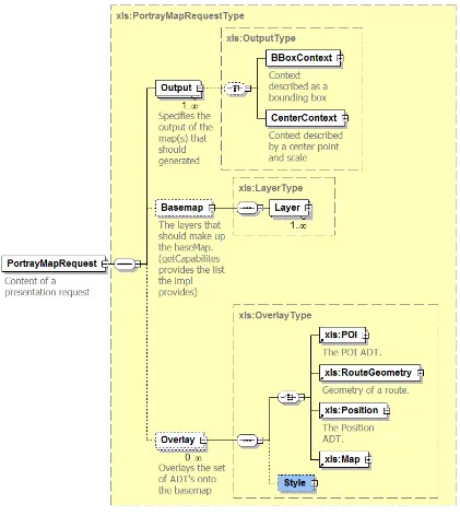
15.4 Part 4: Presentation Service
This service renders geographic information for display on a Mobile Terminal. Any OpenLS Application may call upon this service to obtain a map of a desired area, with or without map overlays that depict one or more OpenLS ADTs, such as Route Geometry, Point of Interest, Area of Interest, Location, Position and/or Address. The service may also be employed to render route directions from Route Maneuver List ADT and/or Route Instructions List ADT.
15.4.1.1 Output Parameters
Defines what the size and encoding of the portrayed map should be using the following criteria:
Width – The width of the map in pixels.
Height – The height of the map in pixels.
Format – Parameter that specifies what the encoding of the map should be. This is specified as a mime-type. The mime-types supported are left up to the implementation.
Transparency - Boolean that defines the opacity of the background of the map.
Background Color – Defines the background color of a map if it is opaque.
The default behavior of the map is to return the exact image size as specified in the request. The Harmonization group is working on harmonizing the different OGC Standards such as WMS and OpenLS, to have consistent behavior where both specs are concerned.
15.4.1.2 Context
Defines what area of the world the map is portraying. This can be defined in the following ways:
Bounding Box- Two-point box in a specific SRS that defines the extents of the map (WGS 84 is the default). This is the same bounding box used in WMS and is present for compatibility with it.
Center Point and Scale - The center point defines the center of your map at a particular scale and projection.
o Center Point – The center point of the map. This point is
specified in WGS 84 as a latitude/longitude in decimal format.
o Scale – The ratio between device units and world units.
Specified as the number of world units per device units. Thus 1:50000 would be expressed as a scale of 50000.
o Azimuth – The orientation of the map. This is expressed in clockwise degrees from north.
o DPI – Dots per inch of the device.
o SRS – Spatial Reference System. Provides what projection should be used when creating the map.
o DisplayScale - A ratio of distance. For example 1:5000
would be expressed as 5000, it's always expressed per 1 pixel of the display.
If context is not specified the implementation must derive it from the ADTs.
15.4.1.3 Overlays
Defines a list of ADTs for portrayal on the map.
o Z Order – The order in which the ADTs are laid on top of each other over the base map.
Custom Style – This is either a named-style or a user-defined style. This standard does not define a specific format for style description. This is a placeholder for custom extensions to use. Also, a placeholder for future versions to define.
If a style is not specified it is up to the implementation to use a default.
15.4.1.4 Base Map
Provides a backdrop for the ADTs and is made up of a set of layers. The user determines the layers that are to be included or excluded from the base map in their request. The implementation must create and support its own list of layers for the user to choose from.
Layers – The list of layers of interest
o Filter – Determines if the layers are included or excluded. “Give me
only the following layers” or “Give me all layers but the following”. The default behavior is to include all the layers. But when filters need to be applied that’s when they would need to be defined.
Custom Style – This is either a named-style or a user-defined style. This standard does not define a specific format for style description. This is a placeholder for custom extensions to use. Also, a placeholder for future versions to define.
If a style is not specified it is up to the Implementation to use a default.
15.4.1.5 Style
Defines how the ADTs should look. The implementation should create and support their own list of styles for the consumer to choose from.
Named Style – A string that is provided by the implementation.
15.4.1.6 Get Capabilities
Provides the user with the list of capabilities that the implementation provides. Consists of the following:
Layers - Layers provided by the implementation.
Style – Styles provided by the implementation.
Format – Mime-types supported by the implementation.
SRS – Spatial Reference Systems supported, in EPSG:XXXX format.
15.4.2 Use Cases
15.4.2.1 Use Case 1
Joe User wants to see where his house is located on a map. To satisfy this use case the presentation service needs to show a base map with the position of Joe’s house overlaid onto it.
For an example see section 15.4.4.1.
15.4.2.2 Use Case 2
Planning a family road trip, Joe User wants to see how get from his house in Calgary, Alberta, to the hotel he has booked in San Diego, California. To satisfy this use case the presentation service needs to show map(s) with the route and the two points of interest overlaid onto it.
For an example see section 15.4.4.2.
15.4.3 Request and Response Parameters
This section specifies the request and response parameters for the Presentation Service.
15.4.3.1 Request Parameters
REQUEST PARAMETER
REQUIRED DATA
TYPE
DATA DESCRIPTION
Output Parameters
List of Outputs (1 tounbounded)
Height
Integer Number of pixelsFormat
String Mime-typeTransparent
-
Boolean Defaults to true if not specifiedBGcolor
-
String RGB Hex FormatDefaults to “#FFFFFF” (white)
Content
-
URLData
Specifies the type of output the map is returned in whether URL or data for base
64, default value is URL
Bounding Box Context
-
XLS Box 2 point box in a specified SRSCenter Context
-
Azimuth
-
Integer Orientation.Specified in clockwise degrees
from north
SRS
String EPSG:XXXX formatCenter Point
-
XLS Point latitude/longitude WGS84DisplayScale
-
Integer Ratio of world units to a device unit.For example 1:50000 would be specified as
50000
DPI
-
Integer Dots per inch of thedevice
to be displayed
Overlay
-
List of overlays (0 –unbounded)
ADT
XLS ADT CurrentlyPositionADT, RouteADT, POI ADT & MapADT
Style
-
Either a Named Styleor a User Defined Style
Implementation uses a default if neither is
specified
Zorder
-
The order in whichthe overlay’s are laid on top of each other
over the base map
BaseMap
-
Layer
-
String The list of layers thatwill be filtered to make up the base
map
Style
-
String Custom styles areused. This is a placeholder for custom styles or future additions to
the spec
Filter
String Either “include” or“exclude”
Get Capabilities
-
Has no data. SimplyNotes:
2. Either a Bounding Box Context or a Center Context can be specified (not both). If neither is specified, the implementation must derive it from the ADTs.
3. If an implementation provides Get Capabilities, the request can be either a “Portray” request or a “Get Capabilities” request (not both).
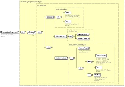
15.4.3.2 Response Parameters
RESPONSE PARAMETER
REQUIRED DATA
TYPE
DATA DESCRIPTION
Map ADT
XLSMapADT
Contains the encoded map, Can have multiple maps if the
request have specified multiple
ones
Get Capabilities Response
Available
Layers
String A list of strings
Available
Formats
String A list MIME-type strings
Available
SRS’s
String A list of
EPSG:XXXX strings
Available
Styles
String A list of strings
Notes:
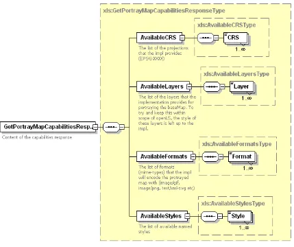
Figure 6 PortrayMap Response
15.4.4 Request and Response Pairs for Use Cases
The following are examples of one way to solve the use cases defined in Section 8; they are not the only solutions.
15.4.4.1 Use Case 1 Example
In order to satisfy Use Case 1, the application must acquire a Position ADT for where Joe’s home is located. One way to do this is to have the Geocoder Service geocode his address, thus determining a Position ADT.
In this example we are asking for:
640x480 image in PNG format
At a scale of 1:20000
In WGS 84 / UTM zone 11N (EPSG:32611) projection
Centered on Joe’s house
Base map will consist of all layers (using default style) made available by the implementation
The location of Joe’s home will be shown using the default style provided by the implementation
Request:
<?xml version="1.0" encoding="UTF-8"?>
<PortrayMapRequest>
<Output width=”640” height=”480” format=”image/png”> <gml:Envelope>
<gml:pos>-114.342 50.234</gml:pos> <gml:pos>-114.123 50.031 </gml:pos>
</ gml:Envelope > </Output>
<!—Ask the impl to exclude no layers (thus, create the base map with all your layers) --> <Basemap filter="Exclude"/>
<Overlay> <Position>
<!-- This ADT contains the lat/lon of Joe's House --> </Position>
</Overlay>
</ PortrayMapRequest >
Response:
<?xml version="1.0" encoding="UTF-8"?>
<PortrayMapResponse>
<!-- There is an OutputResponse for each Output request (in the same order as requested) --> <Map>
<Content width="640" height="480" format="image/png">
<URL> http://www.mapseter.com/lbs/maps/hgtr837468.png </URL> </Content>
<gml:Envelope>
<gml:pos>-114.342 50.234</gml:pos> <gml:pos>-114.123 50.031 </gml:pos>
</ gml:Envelope > </Map>
15.4.4.2 Use Case 2 Example
A prerequisite for this use case are Position ADTs for Joe’s home and the Hotel. We also need the Route ADT, which shows the route from the home to the hotel. The Route ADT may be obtained from the Route Service.
Because the route is very large and we want to see it at a detailed scale we will be asking for multiple maps.
We are asking for:
(N) maps centered on different points of the route
640x480 image in PNG format
At a scale of 1:80000
In UTM projection
With a north orientation
Base map will consist of only the road network and landmarks
The base map and the ADTs will be displayed using the “post-modernistic” style
The position of Joe’s House and the Hotel will be drawn on top of the route
Request:
<PortrayMapRequest>
<Output width=”640” height=”480” format=”image/png”> <gml:Envelope>
<gml:pos>-114.342 50.234</gml:pos> <gml:pos>-114.123 50.031 </gml:pos>
</ gml:Envelope > </Output>
<Output width=”640” height=”480” format=”image/png”> <gml:Envelope>
<gml:pos>>-120.312 48.823 </gml:pos> <gml:pos>-114.123 50.031 </gml:pos>
</ gml:Envelope > </Output>
<Output width=”640” height=”480” format=”image/png”> <gml:Envelope>
<gml:pos>>-120.312 48.823 </gml:pos> <gml:pos>-125.235 46.284</gml:pos>
</ gml:Envelope > </Output>
<Basemap filter="Include"> <Layer name=”Road Network”>
<Style>
<Name>post-modernistic</Name> </Style>
</Layer>
<Layer name=” Landmarks”> <Style>
<Name>post-modernistic</Name> </Style>
</Layer> </Basemap>
<Overlay zorder="0"> <RouteGeometry>
<!-- This ADT contains the route from Joe's Home to the Hotel --> </RouteGeometry>
<Style>
<Name>post-modernistic</Name> </Style>
</Overlay>
<Overlay zorder="1"> <Position>
<!-- This ADT contains the lat/lon of Joe's House --> </Position>
<Style>
<Name>post-modernistic</Name> </Style>
</Overlay>
<Overlay zorder="1"> <Position>
<!-- This ADT contains the lat/lon of the Hotel --> </Position>
<Style>
<Name>post-modernistic</Name> </Style>
</Overlay>
</ PortrayMapRequest >
Response:
<PortrayMapResponse>
<!-- There is an OutputResponse for each Output request (in the same order as requested) --> <Map>
<Content width="640" height="480" format="image/png">
<URL> http://www.mapseter.com/lbs/maps/hgtr837468.png </URL> </Content>
<Output width=”640” height=”480” format=”image/png”> <gml:Envelope>
<gml:pos>-114.342 50.234</gml:pos> <gml:pos>-114.123 50.031 </gml:pos>
</Output> </Map>
<Map>
<Content width="640" height="480" format="image/png">
<URL> http://www.mapseter.com/lbs/maps/hgtr83567.png </URL> </Content>
<Output width=”640” height=”480” format=”image/png”> <gml:Envelope>
<gml:pos>>-120.312 48.823 </gml:pos> <gml:pos>-114.123 50.031 </gml:pos>
</ gml:Envelope > </Output>
</Map>
<Map>
<Content width="640" height="480" format="image/png">
<URL> http://www.mapseter.com/lbs/maps/hgtr83324.png </URL> </Content>
<Output width=”640” height=”480” format=”image/png”> <gml:Envelope>
<gml:pos>>-120.312 48.823 </gml:pos> <gml:pos>-125.235 46.284</gml:pos>
</ gml:Envelope > </Output>
</Map>
</PortrayMapResponse>
15.5 Part 5: Route Service
This service determines a route for a subscriber. The subscriber must use a navigation application to set up the use of the service. They must indicate the start point (usually the position acquired through the Gateway Service, but this could be a planned trip from a specified location, say, from their home), and the endpoint (any location, like a place for which they only have the phone number or an address, or a place acquired through a search to a Directory Service). The subscriber may optionally specify waypoints, in some manner, the route preference (fastest, shortest, least traffic, most scenic, etc.), and the preferred mode of transport. The subscriber may optionally store a route for as long as needed, thus requiring the means to also fetch a stored route.
An enhanced version of this service, the Navigation Service, is described under separate cover (see Normative References, section 10). The Navigation Service supports the same parameters as the Route Service, plus additional parameters for navigation purposes.
9.5.2 Use Cases
that determines the route. Optionally, the user may specify route determination criteria. These criteria might be: fastest, shortest, least traffic, most scenic, etc. and can also specify the preferred mode of transport of the user. The routing algorithm might default to a single criterion, such as fastest. The route can also be optionally stored on the terminal or application server. The user may store it for as long as needed, thus requiring the means to also fetch a stored route.
9.5.3 Request and Response Parameters
9.5.3.1 Route Service Request Parameters
Request Parameters
A collection of one or more of the parameters below
Name Mandatory Data Type Description
RoutePlan Y RoutePlanType Specifies the criteria upon which a new route is determined.
RouteHandle RouteHandleType
(ADT)
Reference to a previously determined route. Used to request additional information about the route, or to request an alternate route.
RouteInstructionsRe quest
N RouteInstructions
RequestType
Requests the return of turn-by-turn route instructions and travel advisories in a text, voice, or other presentation format.
RouteGeometryRequ est
N RouteGeometryR
equestType
Requests the return of the route geometry.
RouteMapRequest N RouteMapReques
tType
Requests the return of one or more maps of the route.
provideRouteHandle N Boolean Requests the return of a route handle.
distanceUnit N DistanceUnitType (ADT)
Specifies the unit for measuring distance. Default = “M”
RoutePlanType: Defines the criteria upon which a route is determined.
Name Mandatory Data Type Description
RoutePreference Y Enumeration Routing preference to be taken into consideration when determining the route:
“Fastest” – Minimize the travel time.
“Shortest” – Minimize the travel distance.
“Pedestrian” – Best route by foot.
WayPointList Y WayPointListTy
pe (ADT)
List of waypoints along the route.
AvoidList N AvoidListType List of areas, locations, and features in which the route should avoid passing through.
useRealTimeTraffic N Boolean Specifies whether to use real time traffic information when determining the best route.
Default is “false”
expectedStartTime N DateTime Specifies the date and time at which travel is expected to begin. The format follows the W3C defintion for DateTime. Reference URL:
AvoidListType: Defines the list of areas, locations, and features in which the route should avoid passing through.
Name Mandatory Data Type Description
AOI N AreaOfInterest
(ADT)
Specifies the geographic areas to avoid.
Address N Address (ADT) Specifies the address for the point to avoid
POI N POI (ADT) Specifies a POI to avoid
Position N Position (ADT) Specifies the locations to avoid.
AvoidFeature N List of
Enumeration
Specifies the types of features to avoid when determining the route:
“Highway” – Minimize the use of highways.
“Tollway” – Minimize the use of tollways.
RouteInstructionsRequestType: Defines the request parameters for turn-by-turn route instructions and travel advisories formatted for presentation.
Name Mandatory Data Type Description
format N String The preferred format of the
route instructions, specified as a mime type.
Defaults to text/plain.
provideGeometry N boolean Default is false
RouteGeometryRequestType: Defines the request parameters for route geometry.
Name Mandatory Data Type Description
BoundingBox N Gml:
EnvelopeType
Rectangular geographic area of route for which the geometry is requested.
If not specified, defaults to full route.
scale N Positive Integer Maximum scale at which the
route will be displayed. Expressed as a ratio of world units to a device unit. For example 1:50000 would be specified as 50000.
Default = 1
provideStartingPortio n
N Boolean If true, return the geometry of the starting portion of the route contained within the specified bounding area, up to the specified maximum number of points.
If false, return the geometry of the complete route
contained within the specified area, reducing the accuracy of the geometry as necessary to not exceed the specified maximum number of points. Default = false
maxPoints N Positive Integer Specifies the maximum number of geometric points to be returned.
RouteMapRequestType: Defines the request parameters for route maps.
Name Mandatory? Data Type Description
Output Y RouteMapOutpu
tType
Specifies the output of the map(s) to be generated.
This is a subset of the map output parameters defined by the Presentation Service.
RouteMapOutputType: Defines the rendered route map output parameters.
This is a subset of the map output parameters defined by the Presentation Service.
A collection of one or more of the parameters below.
Name Mandatory Data Type Description
BBoxContent N Gml:EnvelopeTy
pe
Rectangular area to be displayed in the rendered map.
If not specified, defaults to a rectangular area bounding the full route.
width Y Non-negative
Integer
Pixel width of the resulting map.
height Y Non-negative
Integer
Pixel height of the resulting map.
format Y String Mime type describing the
encoding.
BGcolor N String The background color of the
map
transparent N boolean The opacity of the map.
If set true, the map
is opaque.
9.5.3.2 Route Service Response Parameters
Response Parameters
A collection of one or more of the parameters below.
Name Mandatory Data Type Description
RouteHandle N RouteHandleType
(ADT)
Contains a reference to the route stored at the Route Determination Service server.
Can be used in subsequent requests to the Route Service to request additional
information about the route, or to request an alternate route.
RouteSummary Y RouteSummaryT
ype (ADT)
Describes the overall characteristics of the route.
RouteGeometry N RouteGeometryT
ype (ADT)
Contains the route geometry.
RouteInstructionsList N RouteInstructions ListType (ADT)
Contains a list of turn-by-turn route instructions and
advisories, formatted for presentation.
May contain the geometry and bounding box if specified in the request.
May contain description. For example this can be used to connect the instruction with a map.
type of map to be generated whether an overview or maneuver.
May contain description. For example this can be used to connect the instruction with a map.
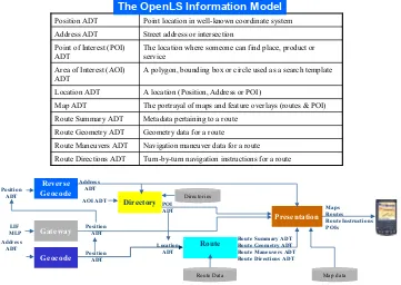
16 OpenLS Information Model
The OpenLS Core Services exchange content in the form of well-known OpenLS
Abstract Data Types (ADTs). Collectively these ADTs comprise the OpenLS Information Model (Figure 7).
Route
Turn-by-turn navigation instructions for a route Route Directions ADT
Navigation maneuver data for a route Route Maneuvers ADT
Geometry data for a route Route Geometry ADT
Metadata pertaining to a route Route Summary ADT
The portrayal of maps and feature overlays (routes & POI) Map ADT
A location (Position, Address or POI) Location ADT
A polygon, bounding box or circle used as a search template Area of Interest (AOI)
ADT
The location where someone can find place, product or service
Point of Interest (POI) ADT
Street address or intersection Address ADT
Point location in well-known coordinate system Position ADT
The OpenLS Information Model