63
Using Landsat-8 Imagery Data on Mapping of the Seagrass Distribution in
Matahari Island, Pulau Banyak District, Aceh Province, Indonesia
Syahrul Purnawan1*, Fauzan Aulia1, Teuku Khairuman2
1 Department of Marine Science, Faculty of Marine and Fishery Sciences, Syiah Kuala University, Banda Aceh 23111,
Indonesia; 2 Department of Physic, Faculty of Mathematics and Natural Sciences, Syiah Kuala University, Banda Aceh
23111, Indonesia . *Corresponding author email: [email protected]
Received : 17 July 2016 Accepted : 25 Agustus 2016 Online : 31 Agustus 2016
Abstract- seagrass meadow has important role as its high productivity in the coastal ecosystem. The reliable information about seagrass extent is essential for proper conservation and management process. Due to their submerged habitat, the seagrass distribution information yet still limited, particularly in Matahari Island, Aceh Province. The acquisition process of seagrass bed information requires remote sensing data along with local expertise and field sampling. The objective of the present study was to gathers information about the seagrass distribution area using the remote sensing that retrieved from Landsat-8 on 28th May 2014. Analysis of Landsat-8 image could be classified into 6 different classes;
seagrass, coral reefs, sand, land, sea, and cloud. Ground check in ten sampling points was performed in 22-26 August 2014 to compare in situ evidence to image analytical results. The agreement between the processed image of seagrass bed and ground truth reference was 70%. The seagrass ecosystem is well distributed along the Matahari Island, with the total area approximately 44.0123 ha. There were five species found in Matahari Island Waters ie. Cymodocea serrulata, C. rotundata, Enhalus acoroides, Thalassia hemprichii and Syringodium isoetifolium
Keywords: Seagrass; Lyzenga algorithmic method; Unsupervised classification Introduction
Seagrass is an angiosperm and one of the most productive ecosystem in shallow marine waters (Tomascik et al., 1997). Seagrass plays the important role in aquatic systems, for example, produce and export organic carbon, nutrient cycle, producing oxygen in coastal waters, sediment traps and prevent coastal erosion, highly diverse, habitat for many fishes and transfer trophic to the adjacent neighborhood, especially in the tropics and temperate region (Kikuchi, 1980; Orth et al., 2006; Hemminga and Duarte, 2000). In addition, related to the area of nursing, the seagrass has a vital function in diversity, abundance, growth, and survival of aquatic organisms (Coles et al., 1993; Heck Jr. et al., 2003). Seagrass requires special environmental conditions, differences in environmental conditions may cause variations in the distribution of seagrass species (Hemminga and Mateo, 1996). The present serious global problems is the increasing ecological pressures that can lead to degraded seagrass beds (Orth et al., 2006).
Aceh Province has approximately 2.666 km of coastline and some areas are difficult to visit due to lack of infrastructure (Muchlisin et al., 2013). Presently, there was no scientific report on the presence of seagrass ecosystem in the waters of Aceh until we conducted an expedition to the Matahari Island, Aceh Singkil. This report provides the information on the current condition and coverage areas of seagrass in Matahari Island, Aceh Singkil, Indonesia, and due to lack of facilities the examination was conducted using the remote sensing technique. The seagrass bed in Matahari Island is affected by the water of the Indian Ocean, whereas no river was observed being charged into Matahari Island waters.
Aceh International Journal of Science and Technology
ISSN: 2088-986064
According to Yang and Yang (2009) and Kuriandewa and Supriyadi (2006) the mapping and monitoring of seagrass ecosystems can be performed using the satellite imagery data. This technique has the advantages in large area covering and less costly and time-consuming (McKenzie et al., 2001). The study of seagrass distribution using satellite imagery data in Indonesia is still limited, as many of its presence in remote areas (Roelfsema et al., 2009). This is the first report on the seagrass distribution from Aceh Province, Indonesia. This information is very crucial to plan an effective management strategy for seagrass ecosystem (Sheaves, 2005; Short and Coles, 2004; Waycott et al., 2004), especially in Aceh Province, Indonesia.
Materials and Methods
This study was conducted in Matahari Island waters, which is administratively located in the Pulau Banyak Sub-district, Aceh Singkil District, Indonesia. Due to its relatively small island, Matahari Island was uninhabited by human. This location was chosen after a preliminary study in order to ensure the existence of seagrass beds in the surrounding area. The Landsat-8 Satellite image data in 28th May 2014 was used in this study with 30 m spatial resolution. The band 2 (Blue) and the band 3 (green) were used to eliminate the influence of depth on seabed reflectance (Lyzenga, 1981) as follow:
Y = Ln (Band 2) + Ki/Kj * Ln (Band 3)
Where, Y= Depth-invariant index, Band 2= Blue channel Landsat 8, Band 3= Green channel Landsat 8, Ki / Kj= Attenuation coefficient value.
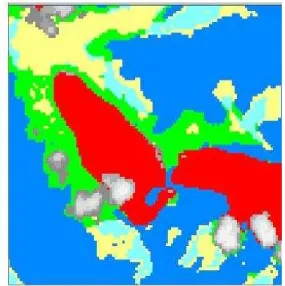
The unsupervised classification techniques automatically classifying similar pixel spectral based on reflected objects (Green and Mumby, 2000). A total of 19 regions was set based on Lyzenga algorithm training site, and it was later set into six classes using unsupervised classification. The extraction results divided into: seagrass, coral reef, sand, mainland, sea and the clouds (Figure 1).
65
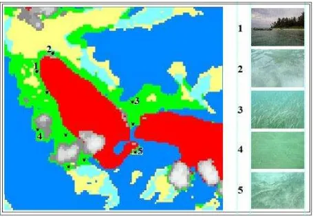
The ground checking was conducted during August 22-26, 2014 to validate the model. The validation process in the field is important in order to validate the obtained results from the model (Yahya et al., 2014). Total of 10 points were chosen purposively to validate the digital data compared with the ground data, and the accuracy test was performed to determine the level of accuracy of seagrass distribution based image classification results with the existing conditions in the field (Figure 2). Test results of the classification accuracy, using the equation:
% 100
JSL JKI KI
Where, KI = Accuracy of interpretation, JKI= Total of truth interpretation, JSL= Total of field sample
Results and Discussion
Based on field observations, five species of seagrass were found in the waters of the Matahari Island i.e., Cymodocea serrulata, C. rotundata, Enhalus acoroides, Thalassia hemprichii and Syringodium isoetifolium, where the south side of Matahari Island provides the occurrence of all these species. The northeast side of Matahari Island provides the highest density of seagrass, with Enhalus acoroides was found in dominant. Various parameters such as sandy substrate, shallow water, and conjunction to coral reef were assumed gave advantages for growth of seagrass in the northeast side of Matahari Island. Sediments have a significant influence on the growth and distribution of seagrass, therefore sediment stabilization also plays an important role (Erftemeijer and Herman, 1994; Newell and Koch, 2004). A high abundance of aquatic plants is naturally found in relatively steady water conditions (Madsen et al., 2001). Purnawan (2015) stated that seagrass habitat adjacent to coral reef may result in more stable condition as the coral reef deliver a steady flow through it.
66
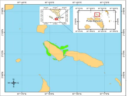
Figure 3. Distribution map of seagrass in Matahari Island, Pulau Banyak Subdistrict, Aceh Singkil
Table 1. The distribution of Matahari Island seagrass.
Site Area (ha)
North east of Matahari Island 1.2069
West of Matahari Island 11.4054
South of Matahari Island 2.9180
East of Matahari Island 28.4820
Based on 10 ground checking points, the seagrass was present in 7 sampling points (Figure 2). So that the seagrass occurrence areas were classified at 70% overall accuracy of classification. A similar result was reported by Dekker et al. (2005) in Kenyan coast, they found the accuracy of classification was 76%. In addition, the higher classification accuracy (90%) was reported by Hashim et al. (2014) in Merambong Shoals, located in the Straits of Johor. Both studies used the similar satellite imagery data (Landsat-TM). However, the lower accuracy classification (56.69%) was reported Setiawan et al. (2012), this study used ALOS satellite with 10 meter spatial resolution. Compared to others, the results showed fairly good agreement with in-situ verifications.
67
that used can affect the level of accuracy is obtained, the better the spatial resolution of an image the better the value of accuracy that can be obtained. The use of imagery from the IKONOS satellite, which has a high resolution may provide solutions to improve the accuracy of image interpretation (Wabnitz et al., 2008). In line with the statement of Yang and Yang (2009) where the results obtained using QuickBird more accurate than the Landsat-TM.
Based on analysis of satellite imagery (Figure 3), seagrass distribution seen in the waters around of Matahari Island. The northeast and south coast of the Matahari Island have a distribution of seagrass in smaller area, compared to the west and east coasts are vaster. The total area of seagrass based image interpretation is approximately 44.0123 ha (Table 1).
Conclusions
Based on the results of image processing it can be concluded that the total area of seagrass beds in the Matahari Island is approximately 44.0123 ha. The west side of Matahari Island possesses the highest extent of seagrass in the area of 32.0730 ha and the lowest is the northeast side with 1.2069 ha. Based on the accuracy test, the occurrence of seagrass areas were classified at 70% overall classification accuracy.
Acknowledgements
The authors would like to thank Ocean Diving Club of Faculty of Marine and Fisheries for support during the study.
References
Coles, R.G., Lee-Long, W.J., Watson, R.A. and Derbyshire, K.J. 1993. Distribution of seagrasses, and their fish and penaeid prawn communities, in Cairns Harbour, a tropical estuary, Northern Queensland, Australia. Australian Journal of Marine and Freshwater Research, 44: 193–210.
Dahdouh-Guebas, F., Coppejans, E. and Van Speybroeck, D. 1999. Remote sensing and zonation of seagrasses and algae along the Kenyan Coast. Hydrobiologia, 400: 63-73.
Dekker, A.G., Brando, V.E. and Anstee J.M. 2005. Retrospective seagrass change detection in a shallow coastal tidal Australian lake. Remote Sensing of Environment, 97: 415-433.
Erftemeijer, P.L.A. and Herman, P.M.J. 1994. Seasonal changes in environmental variables, biomass, production, and nutrient contents in two contrasting tropical intertidal seagrass beds in South Sulawesi, Indonesia. Oecologia, 99: 45–59.
Green, E. P. and Mumby, P.J. 2000. Mapping mangrove. In: Edwards T.M. (ed.), Remote sensing handbook for tropical coastal management. UNESCO Publishing, Rome.
Hashim, M., Misbari, S., Yahya, N.N., Ahmad, S., Reba, M.N. and Komatsu, T. 2014. An approach for quantification of submerged seagrass biomass in shallow turbid coastal waters. Proceedings of International Geoscience and Remote Sensing Symposium, 4439-4442 pp.
Heck Jr., K.L., Hays, G. and Orth, R.J. 2003. Critical evaluation of the nursery role hypothesis for seagrass meadows. Marine Ecology Progress Series, 253: 123–136.
Hemminga, M.A. and Mateo, M.A. 1996. Stable carbon isotopes in seagrasses: variability in ratios and use in ecological studies. Marine Ecology Progress Series, 140: 285-298.
Hemminga, M.A. and Duarte C.M. 2000. Seagrass ecology. Cambridge University Press, Cambridge.
Kikuchi, T. 1980. Faunal relationships in temperate seagrass beds. In: Phillips, R.C., and McRoy, C.P. (eds.), Handbook of seagrass biology: An ecosystem perspective. Garland STPM Press, New York.
Kuriandewa, T.E. and Supriyadi, I.H. 2006. Seagrass mapping in East Bintan coastal area, Riau Archipelago, Indonesia. Coastal Marine Science, 30(1): 154-161.
Ludin, A.N.M., Razak, W.J.W.A., Majid, M.R., Rusli, N., Hardy, A.H.S.A., Kasimon, N. and Noh, M.M. 2011. Mapping of seagrass along Sungai Pulai, Johor, Malaysia. A monograph published by Center for Innovative Development and Planning (CiPD), Universiti Teknologi Malaysia, Johor Bahru.
Lyzenga, D.R. 1981. Remote sensing of bottom reflectance and water attenuation parameters in shallow water using aircraft and Landsat data. International Journal of Remote Sensing, 2: 71-82.
Madsen, J.D., Chambers, P.A., James, W.F., Koch, E.W. and Westlake, D.F. 2001. The interaction between water movement, sediment dynamics and submersed macrophytes. Hidrobiologia, 444: 71-84.
McKenzie, L.J., Finkbeiner, M.A. and Lorlam, H. 2001. Methods for mapping seagrass distribution. In: Short, F.T., and Coles, R.G. (eds.), Global seagrass research methods. Elsevier Science, Amsterdam.
68
Muchlisin, Z.A., Fadli, N., Nasution, A.M. and Astuti, R. 2013. Research note: perception of fishermen community on fishery subsidies and conservation policies in Aceh Besar District, Aceh Province. Depik 2(1): 33-39.
Newell, R.I.E. and Koch, E.W. 2004. Modeling seagrass density and distribution in response to changes in turbidity stemming from bivalve filtration and seagrass sediment stabilization. Estuaries, 27(5): 793-806.
Orth, R.J., Carruthers, T.J.B., Dennison, W.C., Duarte, C.M., Fourqurean, J.W, Heck Jr., K.L., Hughes, A.R., Kendrick, G.A., Kenworthy, W.J, Olyarnik, S., Short, F.T., Waycott, M. and Williams, S.L., 2006. A global crisis for seagrass Ecosystems. BioScience, 56(12): 987-996.
Purnawan, S. 2015. Preliminary study of granulometri on seagrass and coral reef areas: a case study of Pari Island, Seribu Islands. Depik, 4(2): 107-114.
Roelfsema, C.M., Phinn, S.R., Udy, N. and Maxwell, P. 2009. An integrated field and remote sensing approach for mapping seagrass cover, Moreton Bay, Australia. Spatial Science, 54(1): 45-62.
Setiawan, F., Harahap, S.A., Andriani, Y. and Hutahaean, A.A. 2012. Seagrass change detection using remote sensing technology and relation with carbon storage in Banten Bay. Jurnal Perikanan Kelautan, 3(3): 275-286.
Sheaves, M. 2005. Nature and consequences of biological connectivity in mangrove systems. Marine Ecology Progress Series, 302: 293–305.
Short, F.T. and Coles, R.G. 2004. Global seagrass research methods. Elsevier Science B.V., Amsterdam.
Tomascik, T., Mah, A.J., Nontji, A. and Moosa, M.K. 1997. The Ecology of the Indonesian Seas Part Two. The Ecology of Indonesian Series. Vol. VIII. Periplus Editions, Hongkong.
Wabnitz, C.C., Andréfouët, S., Torres-Pulliza, D., Müller-Karger, F.E. and Kramer, P.A. 2008. Regional-scale seagrass habitat mapping in the Wider Caribbean region using Landsat sensors: Applications to conservation and ecology. Remote Sensing of Environment, 112: 3455-3467.
Waycott, M., McMahon, K., Mellors, J., Calladine, A. and Kleine, A.D. 2004. A guide to tropical seagrasses of the Indo-West Pacific. James Cook University, Townsville.
Yahya, N.N., Hashim, M. and Ahmad, S. 2014. Remote sensing of shallow sea floor for digital earth environment. IOP Conference Series. Earth and Environment Science, 18(1): 012110