COMBINING 3D VOLUME AND MESH MODELS FOR REPRESENTING
COMPLICATED HERITAGE BUILDINGS
F. Tsai1,2∗, H. Chang2and Y.-W. Lin2
1Center for Space and Remote Sensing Research 2Department of Civil Engineering
National Central University
300 Zhongda Road, Zhongli Taoyuan, 320, Taiwan [email protected]; [email protected]
KEY WORDS:Building Modeling, 3D Model, Mesh Model, Point Clouds, Level of Detail
ABSTRACT:
This study developed a simple but effective strategy to combine 3D volume and mesh models for representing complicated heritage buildings and structures. The idea is to seamlessly integrate 3D parametric or polyhedral models and mesh-based digital surfaces to generate a hybrid 3D model that can take advantages of both modeling methods. The proposed hybrid model generation framework is separated into three phases. Firstly, after acquiring or generating 3D point clouds of the target, these 3D points are partitioned into different groups. Secondly, a parametric or polyhedral model of each group is generated based on plane and surface fitting algorithms to represent the basic structure of that region. A “bare-bones” model of the target can subsequently be constructed by connecting all 3D volume element models. In the third phase, the constructed bare-bones model is used as a mask to remove points enclosed by the bare-bones model from the original point clouds. The remaining points are then connected to form 3D surface mesh patches. The boundary points of each surface patch are identified and these boundary points are projected onto the surfaces of the bare-bones model. Finally, new meshes are created to connect the projected points and original mesh boundaries to integrate the mesh surfaces with the 3D volume model. The proposed method was applied to an open-source point cloud data set and point clouds of a local historical structure. Preliminary results indicated that the reconstructed hybrid models using the proposed method can retain both fundamental 3D volume characteristics and accurate geometric appearance with fine details. The reconstructed hybrid models can also be used to represent targets in different levels of detail according to user and system requirements in different applications.
1. INTRODUCTION
Detailed and highly accurate three-dimensional (3D) modeling, reconstruction, and visualization of historical monuments and cul-tural buildings or objects is one of the most commonly employed approaches in digital documentation and preservation of cultural heritage and their applications. Although digital 3D reconstruc-tion or modeling of cultural heritage targets has been carried out for decades and a variety of related instruments, algorithms and softwares have been proposed and developed, it still remains as one of the most challenging topics in digital documentation of cultural heritage in terms of research and practice (Koller et al., 2009; Münster et al., 2015). In recent years, 3D point clouds have become one of the most popular data for describing compli-cated heritage buildings or structures in great details. These point clouds can be acquired directly with different sensors and instru-ments such as laser scanning (or LiDAR, Light Detection and Ranging) equipments, or generated from images captured using digital optical cameras and range (depth) cameras or sensors with close-range photogrammetry algorithms.
Digital documentation of cultural heritage usually requires high-density point cloud data. In this regard, terrestrial laser scanning (TLS) has been a popular instrument of choice for data acquisi-tion. However, LiDAR-based point cloud data acquisition sys-tems are usually (relatively) expensive and time consuming. Re-cently, image-based point cloud generation with photogrammet-ric matching algorithms have emerged as a popular alternative for
∗{corresponding author}
obtaining high quality 3D point cloud data (e.g., Alshawabkeh et al., 2010; Dellepiane et al., 2013; Koutsoudis et al., 2014) or used in conjunction with laser scanned data sets (Jamhawi et al., 2016).
For most applications, the point clouds are usually further pro-cessed to produce 3D models of the targets. A fast and eco-nomic modeling approach is connecting all points to form a net-work (mesh) describing the surface geometry, shape, and other property of the target surface. Another approach is to create a parametric, polyhedral, prismatic model deduced from the point clouds.
2. POINT CLOUDS AND MODELS
As described previously, 3D point clouds can be acquired directly using laser scanners or generated from multi-view images using photogrammetric algorithms. In recent years, structure from mo-tion (SfM) and related algorithms (e.g., Faugeras and Lustman, 1988; Rothermel et al., 2012; Wu., 2011, 2013) have become an popular method of choice to generate 3D point clouds from mul-tiple 2D images. In addition to freeware, commercial software such as Photoscan, ContextCapture (Acute3D) and Pix4D are also widely used to create 3D digital surface models of various sites and objects from ground-based or UAV (Unmanned Aerial Vehicles) images. This type of 3D modeling or reconstruction has also been successfully applied to cultural heritage applica-tions (Dellepiane et al., 2013; Stathopoulou et al., 2015; Sun and Cao, 2015; Wenzel et al., 2013) for it does not require expensive equipments and has lower requirements on operations.
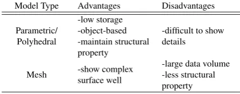
Whether the data are acquired using laser scanners or generated with image-based photogrammetric algorithms, and no matter how dense the data are, 3D point clouds are still discrete points. Although the points may have accurate 3D coordinates, there is no topographic relationship recorded in the original data sets. Therefore, the point clouds are subsequently processed and an-alyzed to produce 3D volumetric or surface models. Recently, after acquiring or generating the 3D point clouds of a cultural heritage site, building, or object, a subsequent processing is usu-ally employed in order to create 3D models of the target. A conventional approach is to construct CAD (computer-aided de-sign) style models in parametric or polyhedral formats. Another emerging strategy is to directly connect the 3D points to gener-ate triangulgener-ated or grid-based mesh networks as a digital surface model (DSM) of the target. Both approaches have their advan-tages and disadvanadvan-tages as summarized and listed in Table-1. For example, on the one hand, parametric or polyhedral models usu-ally requires less storage space and can be easily constructed as object or element-based models to maintain the structural char-acteristics of the targets but they are difficult to show complex surfaces or small structures well. On the other hand, mesh-based models can describe complex surfaces in fine details, but they usually have larger data volumes to store all vertices and con-nections. In addition, although mesh-based models can describe fine details of complex surfaces, they are difficult to maintain the elements or structural property of the targets. In order to take ad-vantages of both approaches, this study developed a framework to integrate 3D volume (parametric or polyhedral) and mesh models for representing complicated cultural heritage buildings in multi-ple levels of detail.
Table 1. Comparison of parametric/polyhedral and mesh-based modeling approaches from 3D point clouds
Model Type Advantages Disadvantages
The proposed 3D modeling framework is separated into three phases. The first stage is the processing of 3D point clouds. One
of the most important task in this stage is the segmentation of point clouds. Effective point clouds segmentation algorithms are available for different data sources, applications and other con-siderations (Grilli et al., 2017). The objective of segmentation is to partition the data into different groups pertaining to differ-ent structure elemdiffer-ents, which will correspond to differdiffer-ent model components of the building.
The second phase is to generate a bare-bones volume model con-sisting of parametric, prismatic, or polyhedral components. The process involves identifying required parameters to shape seg-mented point clouds into parametric or polyhedral model com-ponents describing individual building elements (Teo and Chiu, 2015) , and then connecting all components using CSG (Con-structive Solid Geometry) or similar algorithms to form a bare-bones model representing the skeleton structure of the target. If necessary, additional levels of detail of the bare-bones model can be achieved using procedural (Koehl and Roussel, 2015) or pro-jected generalization (Tsai et al., 2012) algorithms. Figure 1 is an example bare-bones volume model generated from a complicated point clouds of a Chinese style Land God (Tu Di Gong) shrine commonly seen in Chinese descendent communities across China and Southeast Asia. The bare-bones model not only represents the basic geometric shape and formation of the building; it also maintains the fundamental structural attribute of the building.
Figure 1. Point clouds of a Chinese style Land God shrine and its reconstructed bare-bones volume model.
4. EXPERIMENTAL RESULTS
The proposed strategy for generating hybrid models of compli-cated cultural heritage buildings was first applied to an open-source 3D point cloud data set to test its validity and perfor-mance. The open-source 3D point cloud data set was gener-ated by Seitz et al. (2006) for comparing and evaluating differ-ent milt-view stereo reconstruction algorithms and is available at <http://vision.middlebury.edu/mview/data/>. The point cloud was generated from 312 images sampled on a hemisphere of a plaster reproduction of "Temple of the Dioskouroi" in Agrigento, Sicily, Italy and thus is noted as the “temple test case” there-inafter. Figure-2 shows an image of the plaster model and the preliminarily segmented point clouds. Figure-3 shows two views of the reconstructed bare-bones model. As displayed in the fig-ure, the reconstructed bare-bones model has effectively represent the skeleton of the building, which also provides an intuitive pre-sentation of the components making up the entire buildings. As a result, in addition to the skeleton shape and geometric char-acteristics, the model also preserves the fundamental structural property of the building.
Figure 2. Temple of the Dioskouroi and preliminarily segmented 3D point clouds.
Figure 3. Reconstructed bare-bones model from the temple 3D point clouds. The original points are also shown in the figure.
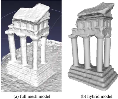
Figure-4 displays the reconstructed full mesh model and a hybrid model of the temple test case. The full-mesh model utilized all original point clouds and consists of hundreds of thousand trian-gles. The hybrid model can significantly reduce the data amount
but still provides fine details of complex surfaces; more impor-tant, it also preserves elemental structural characteristics, as pro-vided by the skeleton bare-bones model, of the building.
(a) full mesh model (b) hybrid model
Figure 4. Full-mesh and hybrid models of the temple test case.
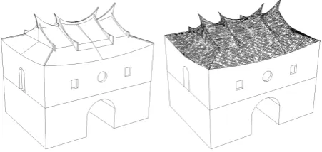
The second test data set is the 3D point clouds of the North Gate of the old Taipei city wall. The construction of Taipei city wall was completed in 1884. However, the wall (except four of the five gates and guarding towers) was completely destroyed by the Japanese colonial government in 1905, 10 years after Japan occupied Taiwan. Among the four surviving gates, the North Gate (Cheng-En Gate) is the most well-preserved and the least-modified one. Two photographs of this heritage structure taken in the 1950’s and modern time are displayed in Figure 5. The 3D point clouds were generated from a 3D model reconstructed using single-view 3D metrology techniques (Chang and Tsai, 2012). Figure 6 illustrates the generated point clouds and two types of mesh-based surface models constructed from the point clouds. Examples of the reconstructed bare-bones and hybrid models are displayed in Figure 7. As can be seen in Figure 7, the hybrid model not only can preserve the basic structural attribute of the entire building; it can also describe the fine details of the roof tiles and ornaments.
(a) in 1950’s ( c!Time Magazine (b) in 2010’s
Figure 5. Photographs of the Taipei City Wall North Gate taken in the 1950’s and modern time.
5. CONCLUSION
(a) 3D point clouds
(b) irregular mesh surface model (c) regular mesh surface model
Figure 6. Point clouds of the North Gate test case and reconstructed mesh-based surface models.
Figure 7. Polyhedral (left) and hybrid (right) models of the Taipei North Gate providing different levels of detail.
using the proposed hybrid modeling approach can significantly reduce the necessary data points to retain the fundamental vol-ume and structural attributes and to preserve detailed elements and surface appearances of complicated heritage buildings. The proposed approach also gives the reconstructed 3D models mul-tiple levels of detail to fulfill different user and application re-quirements. However, a reasonable and systematic LOD defini-tion criteria should be established for this process to be carried out more smoothly. Future improvement of the proposed hybrid modeling framework will also include increase the robustness of mesh and parametric surface blending and increase the degree of automation.
ACKNOWLEDGEMENTS
This research was supported, in part, by the Ministry of Interior of Taiwan (ROC) under Project No. SYC1060303. The authors would also like to thank Prof. Tee-Ann Teo at the National Chiao Tung University of Taiwan for his valuable suggestions about 3D point cloud processing and modeling algorithms.
References
Alshawabkeh, Y., Balawi, F. and Haala, N., 2010. 3D digital doc-umentation, assessment, and damage quantification of the
Al-Deir monument in the ancient city of Petra, Jordan. Conserva-tion and Management of Archaeological Sites12(2), pp. 124– 145.
Chang, H. and Tsai, F., 2012. Reconstructing three-dimensional specific curve building models from a single perspective view image. International Archives of the Photogrammetry, Re-mote Sensing and Spatial Information SciencesXXXIX-B6, pp. 101–106.
Dellepiane, M., Dell’Unto, N., Callieri, M., Lindgren, S. and Scopigno, R., 2013. Archaeological excavation monitoring using dense stereo matching techniques. Journal of Cultural Heritage14(3), pp. 201.
Faugeras, O. D. and Lustman, F., 1988. Motion and structure from motion in a planar environment.International Journal of Pattern Recognition and Artificial Intelligence2(3), pp. 485– 508.
Grilli, E., Menna, F. and Remondino, F., 2017. A review of point clouds segmentation and classification algorithms. Interna-tional Archives of the Photogrammetry, Remote Sensing and Spatial Information SciencesXLII-2/W3, pp. 339–344.
Jamhawi, M., Alshawabkeh, Y., Freewan, A. and Al-Gharaibeh, R., 2016. Combined laser scanner and dense stereo match-ing techniques for 3d modellmatch-ing of heritage sites: Dar es-Saraya museum. Mediterranean Archaeology and Archaeom-etry16(3), pp. 185–192.
Koehl, M. and Roussel, F., 2015. Procedural modelling for re-construction of historic monuments.ISPRS Annals of the Pho-togrammetry, Remote Sensing and Spatial Information Sci-encesII-5/W3, pp. 137–144.
Koller, D., Frischer, B. and Humphreys, G., 2009. Research chal-lenges for digital archives of 3D cultural heritage models.ACM Journal on Computing and Cultural Heritage2(3), pp. 7:1– 7:16.
Koutsoudis, A., Vidmar, B., Ioannakis, G., Arnaoutoglou, F., Pavlidis, G. and Chamzas, C., 2014. Multi-image 3D recon-struction data evaluation. Journal of Cultural Heritage15(1), pp. 73–79.
Lai, L. M. and Yuen, M. M. F., 2015. Blending of mesh objects to parametric surface.Computers & Graphics46, pp. 283–293.
Münster, S., Kuroczy´nski, P., Pfarr-Harfst, M., Grellert, M. and Lengyel, D., 2015. Future research challenges for a computer-based interpretative 3D reconstruction of cultural heritage - a German community’s view. ISPRS Annals of the Photogram-metry, Remote Sensing and Spatial Information Sciences II-5/W3, pp. 207–213.
Rothermel, M., Wenzel, K., Fritsch, D. and Haala, N., 2012. SURE: Photogrammetric surface reconstruction from imagery. In:Proceedings LC3D Workshop, Berlin, Germany.
Seitz, S., Curless, B., Diebel, J., Scharstein, D. and Szeliski, R., 2006. A comparison and evaluation of multi-view stereo re-construction algorithms. In:CVPR2006, Vol. 1, pp. 519–526.
Stathopoulou, E. K., Georgopoulos, A., Panagiotopoulos, G. and Kaliampakos, D., 2015. Crowdsourcing lost cultural heritage.
Sun, Z. and Cao, Y. K., 2015. Data processing workflows from low-cost digital survey to various applications: Three case studys of Chinese historic architecture.International Archives of the Photogrammetry, Remote Sensing and Spatial Informa-tion SciencesVolume XL-5/W7, pp. 409–416.
Teo, T.-A. and Chiu, C.-M., 2015. Pole-like road object detec-tion from mobile lidar system using a coarse-to-fine approach.
IEEE Journal of Selected Topics in Applied Earth Observa-tions and Remote Sensing8(10), pp. 4805–4818.
Tsai, F., Lin, W.-J. and Chen, L.-C., 2012. Multi-resolution rep-resentation of digital terrain and building models. In: W. Shi, M. Goodchild, B. Lees and Y. Leung (eds),Advances in
Geo-Spatial Information Science, Vol. 10, ISPRS Book Series, pp. 233–242.
Wenzel, K., Rothermel, M., Fritsch, D. and Haala, N., 2013. Im-age acquistion and model selection fro multi-view stereo. In-ternational Archives of the Photogrammetry, Remote Sensing and Spatial Information SciencesXL-5/W1, pp. 251–258.
Wu., C., 2011. VisualSFM: A visual structure from motion sys-tem. In:http://ccwu.me/vsfm/.