O R I G I N A L A R T I C L E
Soil-hydrological properties response to grazing exclusion
in a steppe grassland of the Loess Plateau
Tie-Niu Wu•Gao-Lin Wu• Dong Wang• Zhi-Hua Shi
Received: 31 July 2012 / Accepted: 5 April 2013 / Published online: 23 April 2013
ÓSpringer-Verlag Berlin Heidelberg 2013
Abstract Soil–water characteristics are necessary for water quality monitoring, solute migration and plant growth. Soil–water characteristic curve (SWCC) is a rela-tionship between suction and water content or degree of saturation. However, little information is available con-cerning the impacts of grazing exclusion management on soil–water characteristics. Here, the soil–water character-istics of grasslands, which were excluded grazing for 5 (GE5) and 15 years (GE15), were studied. The saturated hydraulic conductivity (Ks), SWCC, particle composition, field capacity and some other indexes were determined. Results showed that the clay content and Ks of grassland soil were higher for GE15 than GE5. For both treatments, in low suction condition (B100 kPa), the water holding capacity of 0–10 cm soil was the best. Water holding capacity of topsoil decreased gradually with the increasing of suction, and it reached the strongest when the suction reached 600 kPa. In all soil water suction, the water holding capacity of subsoil was the weakest. The van Genuchten expression was applicable for most of the samples, except 20–30 cm of GE5 and 10–20 cm of GE15.
Dual porosity equation was applicable for all the samples. The soil–water capability and soil structure of which was fenced for 15 years is superior to that of 5 years. This study suggests that the enclosure management improved the soil structure and soil–water capability.
Keywords Grazing exclusionArid-grassland Soil–water characteristic curveThe Loess Plateau
Introduction
Most of grasslands in the earth are over-used and poorly managed (Oldeman 1994). The overuse of grassland is driven by the demand for forage production since signifi-cant portions of world milk (27 %) and beef (23 %) pro-duction occurs on grasslands managed solely for those purposes (Sere et al. 1995). A well-known management tool to restore the degraded grassland is the establishment of enclosures, denoting areas closed off for agriculture and grazing for a specific period of time. Hopkins and Wain-wright (1989) established the extent of changes in botanical composition since the early 1970s in enclosed grassland in upland areas to relate the extent of changes to the present agricultural management. Su et al. (2005) studied the soil physical properties in Inner Mongolia and found that the particle size distribution showed more silt and clay in the top soil under the non-grazed sites compared with soils under the continuously grazed site. Li et al. (2011) exam-ined soil physical properties under continuous grazing and exclusion of livestock for 8 years in Horqin sandy grass-land, and they found that exclosure increased the fine sand and silt?clay contents, which were similar with the results of Su et al. (2005). Verdoodt et al. (2009) assessed the vegetation and soil rehabilitation in a 23-year T.-N. WuG.-L. WuD. WangZ.-H. Shi (&)
State Key Laboratory of Soil Erosion and Dryland Farming on the Loess Plateau, Northwest A&F University, Yangling 712100, Shaanxi, People’s Republic of China
e-mail: [email protected]
T.-N. Wu
Urban Construction Departments of Shaoyang University, Shaoyang 422000, Hunan, People’s Republic of China
G.-L. Wu (&)D. Wang
Institute of Soil and Water Conservation of Chinese Academy of Science & Ministry of Water Resource, Yangling 712100, Shaanxi, People’s Republic of China
chronosequence of two different enclosure management types. The result showed that the communal enclosure strategy proved to be successful in improving both range-land vegetation and soil health. Shi et al. (2010) examined the characteristics of vegetation and soil properties in the livestock-excluded pastures and the adjacent grazed pas-tures under two topographic habitats and found that live-stock exclusion increased soil bulk density, soil water content, the water retention ability of the soil, and also effectively protect soil from loss by water erosion.
The soil–water characteristic curve (SWCC) is a rela-tionship between suction and water content or degree of saturation. Recently, laboratory measurements of soil– water characteristics have been used to study the effects of bulk density changes on soil hydraulic properties (Lv et al. 2004), and the effect of soil compaction on hydraulic properties of the loess (Zhang et al. 2006). As the mea-surement of soil–water characteristics is costly and diffi-cult, Saxton et al. (1986) derived equations to estimate continuous relationships of soil–water moisture content to potentials and hydraulic conductivity from soil textures. More recently, Fredlund and Xing (1994) proposed a new equation that can be used to fit laboratory data over the entire soil suction range.
SWCC vary widely and nonlinearly with water content for different soil textures (Saxton et al.1986). Ng and Pang (2000) studied the soil water characteristics of a volcanic soil in Hong Kong and found that the SWCC of a re-compacted specimen was very different from that of a natural sample having the same initial soil density and initial water content. Agus et al. (2001) studied the SWCC of Singapore residual soils. They found that the equations proposed by Fredlund and Xing (1994) are a reasonably good estimate of the SWCC for Singapore residual soils. However, in the semiarid China, the widely distributed soil is loess and black loam rather than residual soils or vol-canic soils. The studies on black loam of enclosed grass-land focus on soil carbon, soil microbiology, etc. (Contant et al.2001; Zaller 2006; Verdoodt et al.2009). Neverthe-less, very limited research has been conducted on the SWCC of fenced grassland soil. Soil–water characteristics are necessary for many soil–water related investigations such as water conservation, irrigation scheduling, solute migration and plant growth. These investigations com-monly require soil–water characteristics for the computa-tions of soil–water storage and soil–water flow. Thus, further studies are needed to obtain a database for model parameters and to extend the knowledge in this respect.
In this paper, the evaluation of changes in soil–water characteristics (soil porosity, water content, field capacity, saturated hydraulic conductivity, mechanical components, and bulk density) of two grazing exclusion treatments (5-and 15-year) was made to determine whether long-term
exclusion of livestock grazing can significantly affect soil water properties. The purpose of this study is to understand the effects of long-term grazing exclusion on soil structure and water storage function of typical steppe ecosystem in the Loess Plateau.
Materials and methods
Study site
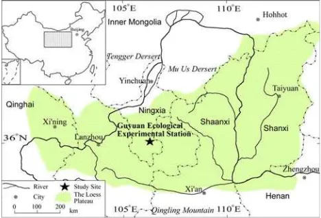
This experiment was conducted in typical steppe grassland at 2,000 m a.s.l. in the Loess Plateau at the Guyuan Eco-logical Experimental Station of Chinese Academy of Sci-ences (36°130–36°190 N, 106°240–106°280 E) in Ningxia
Province, P. R. China, which was shown in Fig.1. The Chinese Loess Plateau lies in the Northwest of China, the loess-paleosol sequences range between*100 and 300 m
in thickness and record aridity in desertified source regions in northwestern China and Mongolia during glacial peri-ods, while intercalated paleosols reflect intensified summer monsoon conditions that supported soil formation during interglacial periods. The Chinese Loess Plateau includes three geomorphological units: the Eastern Loess Plateau, the Central Loess Plateau and the Western Loess Plateau. The Western Loess Plateau lies to the west of Liupan Mountains; the mean annual precipitation decreases from ca. 600 mm/a in the southeast to ca. 200 mm/a in the northwest, with modern vegetation ranging from forest-grassland, grassland and desert forest-grassland, along the same gradient. Loess deposits in this region typically are coarse-grained, and the paleosols are relatively weakly developed (Chen et al.1997).
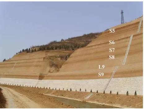
The geological loess profile was shown in Fig.2, which was taken at Caijiapo, Shaanxi Province. On the Loess Plateau, loess deposits consist of two major stratigraphic units, namely loess and paleosol. Loess horizons are
labeled Li and paleosols Si. Paleosols are defined as those units having the appearance and a degree of pedogenic development similar to or greater than the Holocene soil in the same area (Ding et al.1993). In the Caijiapo section, nine major paleosols can be distinguished from the loess units; they were S1–S9. However, the top four paleosols were not shown in Fig.2. Loess can be defined as terres-trial clastic sediment, composed predominantly of silt-size particles, which is formed essentially by the accumulation of wind-blown dust (Pye1995). The predominant compo-nent of the clay fraction of the Chinese loess was illite, which may serve as an indicator for tracing the potential source of loess materials. The clay content of the loess and paleosols was largely controlled by the strength of the winter monsoon, rather than by effects of in situ pedoge-netic processes (Ji et al.1999). For the study site, the mean annual air temperature is 5.0°C. Mean annual precipitation
is 400–450 mm, and 65–75 % of annual precipitation falls from July to September. Annual evaporation is 1,330–1,640 mm and accumulated temperature (C0 °C) is
2,370–2,882°C. The vegetation is typical steppe grassland
dominated by Stipa bungeana Trin., Thymus mongolicus Ronn., Artemisia sacrorum Ledeb., Stipa grandis P. Smirn.,Artemisia frigidaWilld. The soil type in the study area was brown humus soil which was developed from the loess parent material (Cheng et al.2011).
Experimental details
Two community blocks (50950 m) with different graz-ing exclusion times were selected. One was fenced com-pletely excluding grazing from 2005 (GE5), and the other fenced completely excluding grazing from 1995 (GE15). They were dominated by Stipa bungeana,Artemisia sac-rorum, Thymus mongolicus and other forbs. Fifteen ran-domly located sampling quadrats (191 m) in each of the
two community blocks were established. Samples were taken in mid-July of 2010, when biomass had reached its seasonal peak biomass in both years. Undisturbed soil samples were taken from the center of each sampling quadrat of grassland. The soil in each quadrat was removed by layers (0–10, 10–20, 20–30, 30–40 and 40–50 cm) and taken to the laboratory. Fifteen soil samples were repeated in each block, yielding a total of 30 samples. These sam-ples were carried to the laboratory for measuring soil physical properties.
Measurement methods
Grain size was measured with Mastersizer 2000 (Malvern Instruments Ltd. UK), in the State Key Laboratory of Soil Erosion and Dryland Farming on the Loess Plateau, the measurement range is 0.02–2,000lm. No treatment
pro-cedure was adopted, for the aim of this test was to obtain the particle composition of undisturbed soil.
Soil samples were saturated to measure saturated hydraulic conductivity (Ks) by the constant head method (Klute and Dirksen 1986). The soil water retention prop-erties for soil samples were determined using the centri-fugation method (Silva and Azevedo2002). Every sample was first saturated for 24 h and then weighted to determine the soil water content at saturation before submitting them to water extractions by applying centrifuge methods. A HITACHI CR21G centrifuge was used here, with the temperature of 20°C. Although during water desorption
measurement, changing bulk density has an obvious influence on the soil water characteristic curve (Lv et al. 2004), the centrifuge method was considered as an appro-priate method for determining soil water retention proper-ties (Khanzode et al. 2002; Reatto et al. 2008).The bulk density at every degree of suction was measured, and the volumetric water content with the changed bulk density was calculated in the experiment. All data were expressed as mean of quadrat values.
Equations for SWCC and software
A centrifuge is used to measure the soil–water character-istics under various suction states. These curves are fitted by the software named Retention Curve Program (RETC), and obtained the parameters of SWCC. Numerous mathe-matical models have been suggested to describe the SWCC (Brooks and Corey1964; Haverkamp et al.1977; Simmons et al. 1979; van Genuchten1980). In this study, no model was determined before simulation, but to select the optical model according to RETC. Generally, the closer the value of the coefficient of determination,R2, was equal to 1, the better the model fit the data.
Most popular among these functions is the equation of
whereSeis the effective saturation (dimensionless) defined bySe¼ ðhhrÞ=ðhshrÞ; h is volumetric water content (cm3cm-3); hs is the saturated volumetric water content
(cm3cm-3); hr is the residual volumetric water content
(cm3cm-3);his the metric soil water potential (104Pa);a
is a scaling parameter that determines the position of pore size maximum; mand n are dimensionless curve-shape parameters.
Besides van Genuchten equation, another popular function for describing hð Þh has been the equation of Brooks and Corey (1964):
whereais an empirical parameter (L-1) whose inverse is
often referred to as the air-entry value or bubbling pressure, and k is a pore size distribution parameter affecting the
slope of the retention function.
The equation of dual porosity (Durner1994) is given as:
hhr
wherehis the metric soil water potential (104Pa);kis the number of ‘‘subsystems’’ from the total pore size distri-bution;ais a scaling parameter that determines the position
of pore size maximum;mand n are dimensionless curve-shape parameters; wi are weighing factors for the
sub-curves, subject to 0\wi\1, andPwi=1.
RETC is a computer program for analyzing the soil water retention and hydraulic conductivity functions of unsatu-rated soils. It is developed by US Salinity Laboratory. The program uses the parametric models of Brooks–Corey and
van Genuchten to represent the soil water retention curve, and the theoretical pore size distribution models of Mualem and Burdine to predict the unsaturated hydraulic conduc-tivity function from observed soil water retention data (van Genuchten et al.1991).
Results and discussion
Soil physical properties
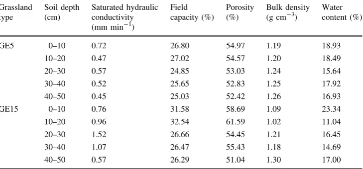
From Table1, it could be seen that there is a great dif-ference in saturated hydraulic conductivity among the ten soil samples. The maximum value is 1.52 mm min-1 in 20–30 cm soil of GE15 grassland, and the minimum value appeared in 40–50 cm soil of GE5 grassland, of only 0.45 mm min-1. In general, the saturated hydraulic con-ductivity of the soil samples of GE15 is greater than that of samples of GE5. For GE5, the saturated hydraulic con-ductivity was smaller than that of GE15 at every layer; especially at the depth of 20–40 cm, theKs of GE15 was much larger than that of GE5. These results indicated that grazing exclusion management could improve the Ks of grassland soil. As for field capacity, the maximum value is 32.54 % in 10–20 cm soil of GE15; 0–10 cm soil of GE15 takes the second place with 31.58 %. The lowest value is 24.85 % in 20–30 cm soil of GE5. Similarly, the field capacity of GE15 was also larger than that of GE5, espe-cially at the depth of 0–20 cm, which showed that for the topsoil, excluded grazing for 15 years could improve the soil water capability more than that of 5 years.
The soil bulk density is relatively low. The maximum is 1.30 g cm-3, appeared in 40–50 cm soil of GE15 grass-land; the minimum value is 1.02 g cm-3, appeared in 10–20 soil of GE15 grassland. The bulk density of these samples is lower than the mean value of tilth soil in the Loess Plateau (*1.30 g cm-3). It is mainly due to the
Table 1 Soil physical
properties of two grazing exclusion treatments (5-year, GE5; 15-years, GE15) and five soil depths
GE5 0–10 0.72 26.80 54.97 1.19 18.93
10–20 0.47 27.02 54.57 1.20 18.49
20–30 0.57 24.85 53.03 1.24 15.64
30–40 0.52 25.65 52.83 1.25 17.92
40–50 0.45 25.03 52.42 1.26 16.93
GE15 0–10 0.76 31.58 58.69 1.09 23.34
10–20 0.96 32.54 61.59 1.02 11.04
20–30 1.52 26.66 54.45 1.21 16.45
30–40 1.07 26.47 55.43 1.18 14.69
loose soil structure of the grassland at the study site. For GE15, the bulk density was smaller than that of GE5 at the depth of 0–40 cm, which could be attributed to more humus and less trample of livestocks. A similar result was obtained for the burnt and unburnt savanna in West Africa, where the highest bulk density (1.5 g cm-3) was found in unburnt subplots with high grazing pressure (Savadogo et al.2007), which implied that enclosure lessened the bulk density of the soil. Table2shows the particle composition of the soil samples. The clay content at GE15 was clearly higher than that of GE5, while the sand content of GE15 is relatively low. It might also be due to the added humus. For a kindred study in Horqin, the enclosure had higher silt?clay (\0.05 mm) and fine sand (0.1–0.05 mm) contents and lower coarse sand contents at all depths than at the continuous grazing site (Li et al.2011). Enclosure management could obviously improve the silt content in grassland soil.
From Tables 1and2, it could be seen that the physical properties of soil were improving after grazing exclosure. The improvements can be mainly ascribed to vegetation recovery and litter accumulation compared with a site subjected to continuous grazing (Su et al.2005).
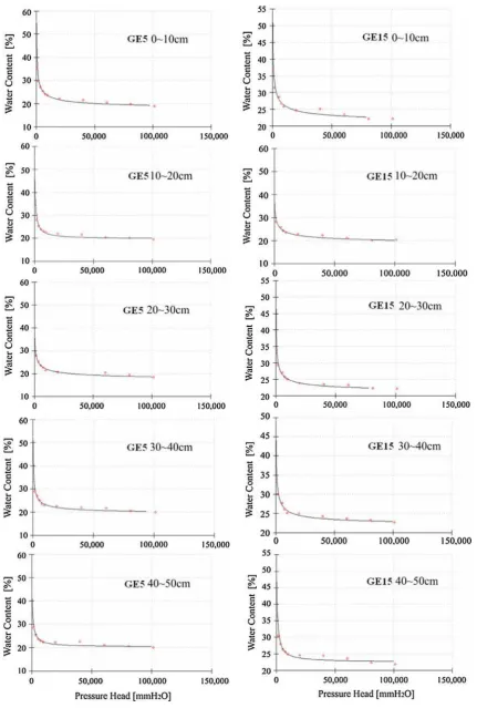
Soil–water characteristics curves
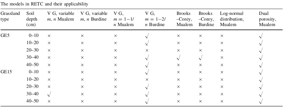
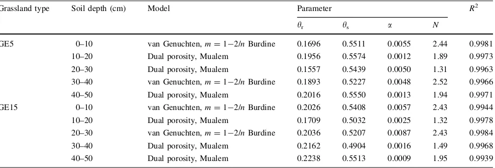
By fitting the eight SWCCs with RETC 6.2, for every curve, no less than one out of the eight models in RETC could fit it. The best fitted one was selected as the SWCC model for every sample. Table3shows this result, and Table4shows the models and parameters fitted to the ten samples.
It is worth noting that although the van Genuchten expression (m=1-1/n Mualem) is widely used due to its flexibility and simplicity, it is not widely used in the SWCC of these samples. Meanwhile, dual porosity equation is applicable for all the samples. In addition, log-normal
Table 2 Characteristics of
particle composition of soil samples of two grazing exclusion treatments (5-year, GE5; 15-years, GE15) and five soil depths
Grassland type Soil depth (cm)
Md (lm) Clay (\2lm)
Silt (2–50lm)
Sand ([50lm)
GE5 0–10 28.502 6.42 68.91 24.67
10–20 25.898 11.54 66.94 21.52
20–30 28.977 6.86 71.79 21.35
30–40 21.816 14.20 68.88 16.92
40–50 21.774 14.32 68.62 17.06
GE15 0–10 24.969 10.82 66.24 22.94
10–20 23.959 13.54 66.72 19.72
20–30 23.841 13.74 66.86 19.40
30–40 21.772 14.12 69.46 16.42
40–50 20.348 14.71 69.92 15.37
Table 3 The relationship between models in RETC and SWCC of soil samples of two grazing exclusion treatments (5-year, GE5; 15-years,
GE15) and five soil depths
The models in RETC and their applicability
Grassland type
Soil depth (cm)
V G, variable
m,nMualem
V G, variable
m,nBurdine V G,
m=1-1/
nMualem
V G,
m=1-2/
nBurdine
Brooks –Corey, Mualem
Brooks –Corey, Burdine
Log-normal distribution, Mualem
Dual porosity, Mualem
GE5 0–10 9 9 9 H 9 9 9 H
10–20 9 9 9 H 9 9 9 H
20–30 9 9 9 9 9 9 9 H
30–40 9 9 9 H H H 9 H
40–50 9 9 9 H 9 9 9 H
GE15 0–10 9 9 9 H 9 9 9 H
10–20 9 9 9 9 9 9 9 H
20–30 9 9 9 H 9 9 9 H
30–40 H 9 9 H 9 9 9 H
distribution equation and van Genuchten (variablem,n Bur-dine;m=1-1/nMualem) equations are applicable for none of the samples. The Brooks–Corey equation only fits one sample, for it has been shown to produce fairly accurate results for many coarse-textured soils characterized by rela-tively narrow pore- or particle size distributions (large
k-values). Results have generally been less accurate for
fine-textured and undisturbed, structured field soils, because of the absence of a well-defined air-entry value for these soils. Figure3 shows the SWCCs to the experimental data, obtained for the ten soil samples, using RETC. For both treatments, in low-suction condition (B100 kPa), the water holding capacity of topsoil (0–10 cm) was the best, bottom soil (30–50 cm) took the second place, and that of subsoil (10–30 cm) was the weakest. With the suction increasing, the water holding capacity of topsoil decreased gradually; when the suction reaches 600 kPa, the water holding capacity of bottom soil was the strongest. In all soil water suction, the water holding capacity of subsoil was the weakest. From the fitting curves, the changing trend of F (0–10 cm of GE15) and G (10–20 cm of GE15) are rela-tively stable; suggesting that in the range of effective suction, the water capacity of grassland soil of GE15 is better than that of the grassland soil of GE5, which is the same as the result of field capacity.
That may be due to the porosity. As Table2shows, the porosity of F and G are relatively large, are 58.69 and 61.59 %, respectively. However, the porosity of 15–5 is only 51.04 %, which is the lowest value among the ten samples. For undisturbed soil, if the porosity were large, the water in big gap has been emptied in the low-suction condition. And the fine pores have strong suction force, so the larger soil suctions the less dehydrated water when the same suction is increased. The slope of the curve in the de-saturation zone tends to become flatter as the soil porosity becomes smaller.
Therefore, at low suction values (B100 kPa), the water capacity of soil with large porosity is stronger than that of soil with small porosity; while in high-suction condition (C100 kPa), the water capacity of soil with large porosity is weaker than that of soil with small porosity. For the soil water content of the same depth, at every suction degree, GE15 grassland is higher than that of GE5 grassland, which showed that grazing exclusion management significantly increased soil water retention in studied grasslands. How-ever, a study in the middle reaches of Kherlen River revealed that there were no significant differences in total porosity, storage pores for available water, and mesopores between the grazing exclusion and grazed grasslands soils (Hoshino et al.2009). This difference might be due to the particularity of the loess and the enclosed time.
Conclusions
In general, fencing improved the soil physical properties for semiarid grassland. The saturated hydraulic conduc-tivity and field capacity of the soil samples of GE15 were greater than that of samples of GE5, while for GE15, the bulk density was smaller than that of GE5 at the depth of 0–40 cm, which could be due to the adding humus.
For both treatments, in low-suction condition (B100 kPa), the water holding capacity of topsoil (0–10 cm) was the best, bottom soil (30–50 cm) took the second place, and that of subsoil (10–30 cm) was the weakest. With the suction increasing, the water holding capacity of topsoil decreased gradually; when the suction reaches 600 kPa, the water holding capacity of bottom soil was the strongest. In all soil water suction, the water holding capacity of subsoil was the weakest. That may be due to the porosity. Soils have large particles and pores mean that although they hold large amounts of water, they do not retain the water for long, as the
Table 4 Models and parameters for soil samples of two grazing exclusion treatments (5-year, GE5; 15-years, GE15) and five soil depths
Grassland type Soil depth (cm) Model Parameter R2
h
r hs a N
GE5 0–10 van Genuchten,m=1-2/nBurdine 0.1696 0.5511 0.0055 2.44 0.9981
10–20 Dual porosity, Mualem 0.1956 0.5574 0.0012 1.89 0.9973
20–30 Dual porosity, Mualem 0.1557 0.5439 0.0050 1.31 0.9963
30–40 van Genuchten,m=1-2/nBurdine 0.1893 0.5227 0.0048 2.52 0.9966
40–50 Dual porosity, Mualem 0.2016 0.5550 0.0013 1.94 0.9971
GE15 0–10 van Genuchten,m=1-2/nBurdine 0.2026 0.5408 0.0057 2.43 0.9944
10–20 Dual porosity, Mualem 0.1709 0.5032 0.0025 1.32 0.9978
20–30 van Genuchten,m=1-2/nBurdine 0.2036 0.5207 0.0087 2.43 0.9984
30–40 Dual porosity, Mualem 0.2162 0.4904 0.0016 1.49 0.9968
water leaks through the pores. Clay soils are on the opposite end of the spectrum. They have the smallest particles and pores, which cause low porosity and high retention. Silt soils also have high water retention, and loam soil has medium retention. The van Genuchten expression was applicable for most of the samples, except 20–30 cm soil of GE5 and 10–20 cm soil of GE15. Dual porosity equation was appli-cable for all the samples. However, log-normal distribution equation and van Genuchten (Variable m, n Burdine; m=1-1/nMualem) equation were applicable for none of the ten soil samples.
Results suggest that the enclosure management improved the soil structure and soil–water capability. Further study is needed to determine the value ofKs and parameters of SWCC of other enclosure managements, such as the grassland which was enclosed for 10, 20 even 30 years to determine that if it is longer enclosed, the soil physical properties would be better.
Acknowledgments We thank senior technician Shi ZhuYe for her
contribution to the laboratory analysis. This work was supported by ‘‘Strategic Priority Research Program—Climate Change: Carbon Budget and Relevant Issues’’ of the Chinese Academy of Sciences (Grant No. XDA05050403), ‘‘100-Talents Program’’ to Shi Zhi-Hua, and Northwest A&F University (QN2011039), Funds from State Key Laboratory of Soil Erosion and Dryland Farming on the Loess Plateau (10501-1215).
References
Agus S, Leong E, Rahardjo H (2001) Soil–water characteristic curves of Singapore residual soils. Geotech Geol Eng 19:285–309 Brooks R, Corey A (1964) Hydraulic properties of porous media,
Hydrology paper no 3. Colorado State University, Fort Collins, pp 1–27
Chen FH, Bloemendal J, Wang JM, Li JJ, Oldfield F (1997) High-resolution multiproxy climate records from Chinese loess evidence for rapid climatic changes between 70 ka and 10 ka. Palaeogeogr Palaeoclimatol Palaeoecol 130:323–335
Cheng J, Wu GL, Zhao LP, Li Y, Li W, Cheng JM (2011) Accumulative effects of 20-year fencing on above- and below-ground biomass of typical steppe communities in arid areas of the Loess Plateau, China. Plant Soil Environ 57:40–44 Contant R, Paustian K, Elliott E (2001) Grassland management and
conversion into grassland: effects on soil carbon. Ecol Appl 11:343–355
Ding ZL, Rutter NW, Liu TS (1993) Pedostratigraphy of China loess deposits and climatic cycle in the last 2.5 Myr. Catena 20:73–91 Durner W (1994) Hydraulic conductivity estimation for soils with
heterogeneous pore structure. Water Resour Res 32:211–223 Fredlund D, Xing A (1994) Equations for the soil–water characteristic
curve. Can Geotech J 31:521–532
Haverkamp R, Touma J, Vauclin M, Wierengaand P, Vachaud G (1977) A comparison of numerical simulation models for one-dimensional infiltration. Soil Sci Soc Am J 41:285–294 Hopkins A, Wainwright J (1989) Changes in botanical composition
and agricultural management of enclosed grassland in upland areas of England and Wales, 1970–1986, and some conservation implications. Biol Conserv 47:219–235
Hoshino A, Tamura K, Fujimaki H, Asano M, Ose K, Higashi T (2009) Effects of crop abandonment and grazing exclusion on
available soil water and other soil properties in a semi-arid Mongolian grassland. Soil Till Res 105:228–235
Ji JF, Chen J, Lu HY (1999) Origin of illite in the loess from the Luochuan area, Loess Plateau, central China. Clay Miner 34(4):525–532 Khanzode R, Vanapalli S, Fredlund D (2002) Measurement of soil–
water characteristic curves for fine-grained soils using a small-scale centrifuge. Can Geotech J 39:1209–1217
Klute A, Dirksen C (1986) Hydraulic conductivity and diffusivity: laboratory methods. In: Klute A (ed) Methods of soil analysis, Part I, Agron Monogr 9, 2nd edn. ASA and SSSA, Madison, pp 687–734
Li Y, Zhao H, Zhao X, Zhang T, Li Y, Cui J (2011) Effects of grazing and livestock exclusion on soil physical and chemical properties in desertified sandy grassland, Inner Mongolia, northern China. Environ Earth Sci 63:771–783
Lv DQ, Shao MA, Horton R (2004) Effect of changing bulk density during water desorption measurement on soil hydraulic proper-ties. Soil Sci 169:1–11
Ng CWW, Pang YW (2000) Experimental investigations of the soil–water characteristics of a volcanic soil. Can Geotech J 37:1252–1264 Oldeman LR (1994) The global extent of soil degradation. In:
Greenland DJ, Szabolcs I (eds) Soil resilience and sustainable land use. CAB International, Wallingford, pp 99–118
Pye K (1995) The nature, origin and accumulation of loess. Quaternary Sci Rev 7–8(14):653–667
Reatto A, Silva E, Bruand A, Martins E, Lima J (2008) Validity of the centrifuge method for determining the water retention properties of tropical soils. Soil Sci Soc Am J 72:1547–1553
Savadogo P, Sawadogo L, Tiveau D (2007) Effects of grazing intensity and prescribed fire on soil physical and hydrological properties and pasture yield in the savanna woodlands of Burkina Faso. Agr Ecosyst Environ 118:80–92
Saxton K, Rawls W, Romberger J, Papendick R (1986) Estimating generalized soil water characteristics from texture. Soil Sci Soc Am J 50:1031–1036
Sere C, Stenifeld H, Groenewold J (1995) World livestock production systems: current status, issues and trends. Food and Agriculture Organization of the United Nations, Rome
Shi F, Chen H, Wu Y, Wu N (2010) Effects of livestock exclusion on vegetation and soil properties under two topographic habitats in an alpine meadow on the eastern Qinghai-Tibetan Plateau. Pol J Ecol 58:125–133
Silva E, Azevedo J (2002) Influeˆncia do perı´odo de centrifugac¸a˜o na curva de retenc¸a˜o de a´gua em solos de Cerrado. Pesq Agropec Bras 37:1487–1494
Simmons C, Nielsen D, Biggar J (1979) Scaling of field-measured soil–water properties. Hilgardia 50:1–25
Su YZ, Li YL, Cui JY, Zhao WZ (2005) Influences of continuous grazing and livestock exclusion on soil properties in a degraded sandy grassland, Inner Mongolia, northern China. Catena 59: 267–278
van Genuchten MT (1980) A closed form equation for predicting the hydraulic conductivity of unsaturated soils. Soil Sci Soc Am J 44:892–898
van Genuchten MT, Leij F, Yates S, Williams J (1991) The RETC code for quantifying the hydraulic functions of unsaturated soils. US Environmental Protection Agency, Ada
Verdoodt A, Mureithi SM, Ye L, Ranst EV (2009) Chronosequence analysis of two enclosure management strategies in degraded rangeland of semi-arid Kenya. Agr Ecosyst Environ 129:332–339 Zaller J (2006) Sheep grazing vs. cutting: regeneration and soil nutrient exploitation of the grassland weedRumex obtusifolius. Biol Control 51:837–850