DOCUMENTATION FOR EMERGENCY CONDITION MAPPING OF DECORATED
HISTORIC SURFACES AT THE CAID RESIDENCE, THE KASBAH OF TAOURIRT
(OUARZAZATE, MOROCCO)
K.Percya, , C.Ouimeta. S. Warda, M. Santana Quintero a, C.Cancinob, L.Wong b, B. Marcus b, S.Whittaker b, M.Boussalhc. a
Carleton Immersive Media Studio, Carleton University, 1125 Colonel by drive, Ottawa, On, K1S 5B6 Canada [email protected] - [email protected] - [email protected] - [email protected] b
Getty Conservation Institute, 1200 Getty Drive, Suite 700, Los Angeles, CA 90049-1684, USA – [email protected], [email protected], [email protected], [email protected]
c
Center for Conservation and Rehabilitation of the architectural Heritage of the Atlas and sub-Atlas zones (CERKAS), Kasbah Taourirt, BP 253 Ouarzazate, Morocco - [email protected]
Commission VI, WG VI/4
KEY WORDS: 3D imaging, Recording, Photogrammetry, EDM, Computer-Aided Drawing, Conservation, Earthen Architecture, Documentation, Decorated Surfaces.
ABSTRACT:
As it is broadly understood, recording serves as a basis for the diagnosis, treatment and preservation of historic places and contributes to record our built cultural heritage for posterity. This work is not a stand-alone practice but a part of the overall conservation process of cultural heritage at imminent risk of irreversible damage. Recording of heritage places should be directly related to the needs, skills and the technology that are available to the end users that are responsible for the management and care of these sites. They should be selected in a way that the future managers of these sites can also access and use the data collected. This paper explains an innovative heritage recording approach applied by the Getty Conservation Institute (GCI) and Carleton Immersive Media Studio (CIMS) in the documentation of historic decorated surfaces at the Caïd Residence, located at Tighermt (Kasbah) Taourirt in Ouarzazate, Morocco; as part of a collaborative project between the GCI and the Centre de Conservation et Réhabilitation du Patrimoine Architectural des Zones Atlasiques et Sub-Atlasiques (CERKAS) to rehabilitate the entire architectural ensemble. The selected recording techniques were used for the rapid mapping of conditions of the decorated surfaces at the Caïd Residence using international standards. The resulting work is being used by GCI staff, consultants and CERKAS team to conduct emergency stabilization and protection measures for these important decorated surfaces.
1. INTRODUCTION
1.1 Context
Kasbah Taourirt is one of several major earthen ensembles (over 300) located along the former caravan route between the
Sahara dessert and the city of Marrakech in Southern Morocco. This massive earthen complex is located in the city of Ouarzazate, situated about 200km south of Marrakech across the Atlas. According to oral tradition, it was built in the 17th
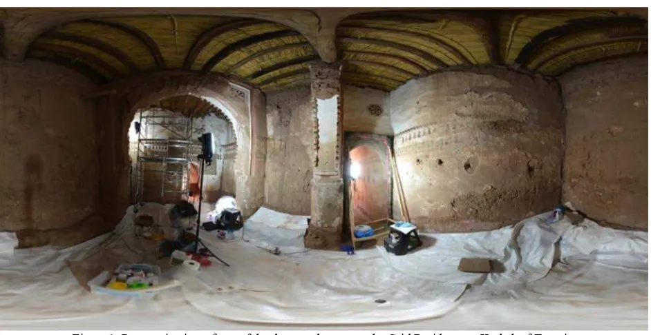
century by the Imzwarn –a family or families with local or regional political power- of the region. Beginning in the 1880s, Figure 1: Panoramic view of one of the decorated rooms at the Caid Residence at Kasbah of Taourirt.
the site was expanded significantly by the Glaoua family, who controlled southern Morocco in the late 19th and early 20th centuries.
During its peak of importance in the late 19th century, held a strategically important location at the confluence of three valleys (Draá, Dades and Zig) controlling the Saharan Caravan Route from Northern to Western Africa. After the French commerce until 2010 where the Municipality of Ouarzazate purchased the site and evicted the settlers. Although part of the site of Taourirt was restored in the 1990s, the most decorative structure of the site, the Caïd Residence, continued to deteriorate due to its abandonment and lack of regular maintenance.
The Caïd Residence contains some of the site’s most significant elements. Based on the site oral history, this sector of the site gypsum panels, elaborated mud brick arches, colourful tataoui ceilings as well as wall paintings (Fig. 1). These decorated surfaces are very rare in traditional Berber architecture and only found in sites influenced by the architecture of the imperial with CERKAS to preserve this important landmark in Morocco. The project aims to develop a methodology for the rehabilitation and conservation of Kasbah Taourirt that can be applied to similar sites in the region.
The objective of documenting the wall paintings was to produce a metric corrected photographic record of the decorated surfaces with sufficient resolution for condition mapping. As underlined by Letellier and LeBlanc (2007), “Heritage Recording is the capturing of graphic and photographic information describing the physical configuration, evolution, and condition of the heritage place…the resulting heritage record is a technical dossier consisting of graphic records that provide the necessary basic data for conservation and conservation related activities”[1]. Observing this statement, the team focused on finding a suitable and reliable surveying technique to produce a set of records which could be used for the condition assessment of the wall paintings and to design a strategy for their conservation.
Given the nature of the earthen architecture and extensive decay of the site, the geometry of the surfaces is very complex and irregular. It is important to also mention that the team had very little time to undertake the recording due to the need of conducting emergency interventions on the damaged surfaces to prevent further decay. The recording was primarily conducted
with close-range photogrammetry techniques and other emerging image processing technologies.
These methods were chosen based on the need to rapidly map the surfaces but also taking into consideration the site irregularity, portability of the equipment and the extent of the spatial geography. Furthermore, it was important that the technologies used for the mapping were cost effective and easy to use by the CERKAS staff.
The resulting orthographic images were used to graphically record the conditions of the wall paintings. Complementary non-invasive technical imaging (visible and infrared reflected and ultraviolet-induced fluorescence) was used to further understand the technology and condition of the paintings (Fig. 2).
2. THE DOCUMENTATION PROCESS
2.1 Selection of documentation techniques and recording approach
Given the low lighting conditions inside the Caïd Residence, the first part of the wall paintings documentation involved taking photographs using a DSLR high resolution digital camera with a low-cost lighting kit consisting of four flashes equipped with diffusers and wireless transmitters mounted on light stands or placed on the floor.
Even lighting was required for consistent and evenly exposed photographs. A sequence of overlapping images was captured ensuring that all of the required surfaces were recorded in at least two images. The photographs were then batch processed for white balance using one adjustment as only the flashes were used as a light source.
As mentioned earlier, due to the limited amount of working time to produce measured drawings the team decided that photogrammetry would be the most efficient method.
The second part of the recording strategy involved measuring control points with a Total Station to allow scaling and orientation of the photogrammetric models. The use of the Total Station permitted georeferencing and location of the decorated surfaces within the context of the Kasbah Taourirt.
Small target stickers were strategically placed to obtain reliable control points but also in locations that would not damage the integrity of these important character-defining elements.
The early results of the survey were promising allowing the use of artificial lighting (flashes and lighting) and the selected resolution to take overlapping photographs using the CIPA 3x3 rules to cover the entire surfaces of the wall paintings.
A user-friendly structure from a motion software package (PhotoScan) was used to create a photogrammetric model from the images using a “multi-image photogrammetry or structure from motion” (McCarthy, 2014, pp. 175)[3] approach. This is a recent product in computer imaging that allows for 3D scenes to be obtained from 2D images using a highly automated workflow with Agisoft Photoscan [4].
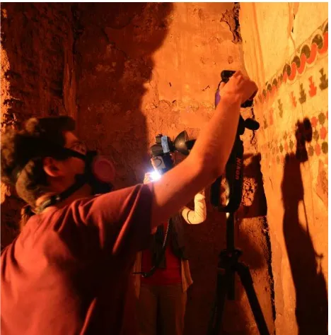
Figure 2: A GCI team member undertaking non-invasive technical imaging.
Furthermore, the survey data collected from a Total Station allowed georeferencing the model in the co-ordinate system of the whole Kasbah survey, obtaining surface and volume measurements as well as the correct geospatial orientation of the model. This model registration also facilitates breaking the model down into ‘photogrammetric chunks’ (wall by wall). All the separate chunks are registered in the same co-ordinate system and they can be loaded, viewed, edited and exported separately or collectively. Models were exported in the OBJ format allowing the open-source software Meshlab [5] to create orthographic photo elevations. These images were then scaled and arranged in AutoCAD, printed and used for the condition recording of the wall paintings.
Once the condition of the wall paintings was recorded and digitized in AutoCAD, these images were then used to re-render the photogrammetric model with the output of the condition recording. This created a three-dimensional model of the wall paintings with the condition phenomena mapped onto the surface allowing spatial visualisation to aid in diagnosis of deterioration patterns. The rendering of the new photogrammetric model (OBJ format) with the wall painting conditions mapped onto the surface was created using Adobe Photoshop’s 3D capabilities. Other uses of the photogrammetric model included animation like a fly through of the space or the detailed view of the wall paintings texture with the lighting of the surfaces with artificial light.
2.2 Non-Invasive investigation of the decorated surfaces
In conjunction with the wall painting condition assessment a range of low cost non-invasive imaging techniques were used to aid in the understanding of materials, condition and phases of painting. These were visible and infrared (IR) reflected imaging, ultraviolet-induced visible fluorescence imaging (UVF) and reflectance transformation imaging (RTI). The techniques were chosen as they are low cost, widely available and provide spatial information across the surface of the wall painting.
A commercially available DSLR with the internal IR-blocking filter removed was used to capture the reflected and fluorescence images. The removal of this filter allows the camera to detect radiation in the range of 365 nm to 1000 nm on the electromagnetic spectrum. Two flashes were used as the source of UV, visible and IR radiation. A range of filters, placed in front of both flashes and the camera, allow the wavelength of the radiation irradiating the painting surface and that which the camera can detect to be manipulated.
Figure 3: Non-invasive imaging. Image A visible reflected image. Image B IR false colour image. Image C is the UV-induced visible fluorescence image.
The resultant RGB visible and IR reflected images were merged to create an IR false-colour image, a technique that is useful for the preliminary identification of pigments and mapping of differences in materials.
These imaging techniques were successfully used to detect and visualise two phases of painting. UVF imaging recorded a red pigment fluorescing orange, whereas in surrounding areas where a similar red has been used this fluorescence was not detected, suggesting a different phase of later painting. Furthermore, these findings were corroborated by the behaviour of the two reds when imaged with reflected IR radiation. The first fluorescent red is invisible to IR, whilst the latter red is clearly visible, suggesting two separate materials and two phases of painting. The IR false-colour images recorded the use of under-drawing to organise the geometry of the motifs used throughout the painted scheme in the Caid Residence. Each geometric element was first outlined with the same pigment that appears bright red in the IR false colour image. Subsequently, the elements were blocked in with alternating red and green.
The RTI images revealed the use of setting-out and under-drawing techniques, used to plan and execute the geometry of the paintings. RTI, as developed by Hewlett-Packard Labs and Cultural Heritage Imaging, recorded topographical information and facilitated the interactive relighting of the painting, revealing the use of incision marks in the setting out of geometric designs.
2.3 Recording the Geometric Configuration of the Caid
According to Watt, it is understood that “annotated drawings are particularly helpful, especially in connection with the diagnosis of defects. By recording observations and survey data of the building, the surveyor is able to consider the problems in three dimensions, relating the presence of internal symptoms to external defects and vice versa”[2]. This is the reason why the project also required the production of measured architectural drawings of the areas where the decorated surfaces are located.
Simultaneously to the recording of the decorated surfaces, another surveying team conducted detailed documentation to prepare a reliable set of floor plans, cross sections and elevation drawings of the Caid Residence.
The architectural survey team used an Electronic Distance Measurement (EDM) equipped Total Stations connected to tablet PCs running AutoCAD. The measurements collected by the EDMs were translated to AutoCAD commands using an off-the-shelf available software called TheoLT.
The EDM Total Stations were also used to support the photogrammetric record and the survey of the individual spaces (plans, elevations and sections), by calculating a survey network of the interior and exterior perimeter of the Caid related to the other areas of the Kasbah already surveyed.
Additionally, photogrammetry was used to ensure that the documentation team captured all the required information in the given time and to provide a photographic record of the captured exterior and interior spaces. This allowed the documentation team to generate 3D models of the recorded rooms that were later used to extract information needed for the production of the architectural plans, sections and elevations. Another advantage of this technique is the production of other deliverables such as sections and plans at different
datum’s/planes, rectified ceiling plans and orthographic photo elevations.
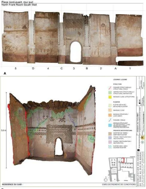
Figure 4: Resulted orthophotograph (A) and 3D condition assessment of ortho photograph (B).
Figure 5: Second floor plan of the Caïd Residence with Kasbah Taourirt indicating location of rooms with decorated surfaces.
The rooms recorded with photogrammetry were captured by defining strips with a 60-80% overlap. The interior of the rooms typically had a cube configuration (four walls, ceiling and floor). Each interior surface was captured with a minimum of three photos (right, centre and left photo) with oblique photos from each corner of the room. This resulted in about 22-30 photos per interior space; which provided sufficient overlap between photos for the bundle registration performed using Agisoft PhotoScan software. The geometry or mesh was then built of all six faces, resulting in a complete 3D model of the space. The same photos used to build the geometry were used to ISPRS Annals of the Photogrammetry, Remote Sensing and Spatial Information Sciences, Volume II-5/W3, 2015
generate a texture. These individual spaces were tied to the project coordinate system, using a minimum of three well-distributed targets within the room that were measured with the Total Station.
The photogrammetric models were primarily used to generate horizontal and vertical profiles at pre-determined datum to support the architectural drawings (plans and sections). Orthographic images were also generated, and brought in the architectural plans or sections to infill areas seen in the projection (door and window openings, reflective ceiling plan information, etc.).
3. PROCESSING
3.1 Photogrammetric Models in Geomagic
During the processing period, the photogrammetric models of most interior and exterior spaces of the Caïd Residence were imported into Geomagic. The same photos used to build the geometry were used to generate a texture. These individual spaces were tied to the project coordinate system, using a minimum of three well-distributed targets within the room that were measured with the Total Station.
The photogrammetric models were primarily used to generate horizontal and vertical profiles at pre-determined datum to support the architectural drawings (plans and sections). Orthographic images were also generated, and brought in the architectural plans or sections to infill areas seen in the projection (door and window openings, reflective ceiling plan information, etc.).
3.2 Integration in CAD (Plans, Section)
The final drawing production is an amalgamation of data produced from survey, photogrammetry and hand measurements. Initially, the drawings produced in TheoLt were standardized and refined with hand measurements and photographs. Once these drawings were legible, information from photogrammetric documentation in the form of orthographic photographs and cut lines were integrated. Section lines were geo referenced and as a result, imported in the accurate location. They were then used as a reference to scale imported orthographic photos that were used as a drawing reference.
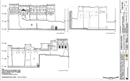
Figure 6: Elevations of the Caïd Residence within the Kasbah Taourirt, created from photogrammetric models.
4. CONSERVATION PLANNING
In addition to record and locate the conditions of the wall paintings, the measured drawings of the Caïd Residence were used to record the architectural conditions of the site (Fig. 7). The drawings were the base maps for properly assessing and mapping deterioration and structural problems, and allowed the team to identify significant and character defining features of the site (Fig. 8). The measured drawings were also used to develop a plan of emergency interventions aimed at protecting the physical integrity of this area. The same set of drawings was then used by CERKAS to prepare a budget of conservation interventions and to select the proper contractor to implement them.
Figure 7: Values assessment of the Caïd Residence.
Figure 8: Interventions planned using the measured drawings of the Caïd Residence.
5. HEALTH AND SAFETY ISSUES RELATED TO THE DECORATED ROOMS AT THE CAID RESIDENCE
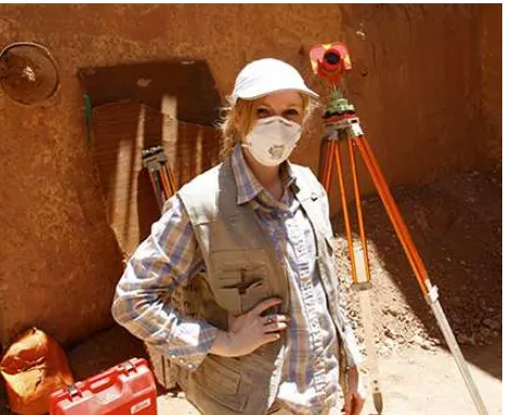
According to Watt (2010) “Safe working access to all parts of a building is an essential prerequisite for a through survey”[5]. The Caïd Residence has extensive structural damage and the decorated surfaces are located in rooms where bats were presently living. These two hazards represented a substantial danger for the recording and assessment team due to possible exposure to serious infections such as Histoplasmosis.
Figure 9: CIMS team member using protective gear during documentation of the Caïd Residence within the Kasbah
Taourirt.
The CIMS and the GCI took necessary precautions for the health and safety of the team and to insure that the risks were mitigated (Fig. 9). The areas to be surveyed and assessed were initially cleaned, structurally assessed and the team was required to use adequate respiratory protection gear. Furthermore, the surveyed techniques chosen allowed the teams to stay only for limited periods of time to capture the necessary geometric configuration of the historic fabric of these spaces.
6. CONCLUDING REMARKS
This contribution focuses on the application of existing and emerging surveying techniques applied for condition mapping of decorated surfaces in historic buildings particularly when the recording process needs to be both reliable and fast in capturing an accurate picture of the geometric configuration of very irregular surfaces.
Tthe use of other non-destructive analytical tools has been presented, as a complementary method to produce images that provide information regarding the paintings technique.
7. FURTHER RESEARCH
Given the team’s expertise in 3D modelling and the potential of on-going photogrammetric developments, further research could be conducted in the following areas:
• 3D models resulting from photogrammetry and their integration to Building Information Systems (BIM) to understand the conditions of historic earthen sites in a holistic manner;
• Procedures for actively monitoring historic earthen structures using new advances in photogrammetry; and,
• Development of a set of guidelines for rapid assessment and recording of historic earthen architecture using low-cost surveying techniques such as photogrammetry.
8. ACKNOWLEDGEMENTS
The authors would like to thanks other Carleton students and
Ekim, Laure Chandelier and Bjorn Van Genechten); current and formers GCI interns (Emilio Roldán Zamarrón, Elena Macchioni, Tim Michiels and Poornima Balakrshnan) and, GCI consultant and wall painting conservator Charlotte Martin de Founjandran.
9. REFERENCES
[1] R. S. Letellier, W. LeBlanc, F. , Guiding Principles Recording, Documentation, and Information Management for the Conservation of Heritage Places. Los Angeles, USA: Getty Conservation Institute, 2007.
[2] D. Watt, Surveying Historic Buildings: Donhead, 2010.
[3] J. McCarthy, "Multi-image photogrammetry as a practical tool for cultural heritage survey and community engagement," Journal of Archaeological Science, vol. 43, 2014.
[4] Agisoft. (2015, 04-06). Agisoft PhotoScan User
Manual. Available:
http://www.agisoft.com/pdf/photoscan-pro_1_1_en.pdf
[5] V. C. L. I.-. CNR. (2015, 04-06). MeshLab. Available: http://meshlab.sourceforge.net