Open Geospatial Consortium
Date: 2011-11-23
Reference number of this document: OGC 11-063r6
Category: Public Engineering Report
Editor(s):Gobe Hobona, Roger Brackin
OGC
®OWS-8 Cross Community Interoperability (CCI)
Semantic Mediation Engineering Report
Copyright © 2011 Open Geospatial Consortium.
To obtain additional rights of use, visit http://www.opengeospatial.org/legal/.
Warning
This document is not an OGC Standard. This document is an OGC Public
Engineering Report created as a deliverable in an OGC Interoperability Initiative and is not an official position of the OGC membership. It is distributed for review and comment. It is subject to change without notice and may not be referred to as an OGC Standard. Further, any OGC Engineering Report should not be referenced as required or mandatory technology in procurements.
Document type: OGC® Engineering Report Document subtype: NA
Preface
The document presents the work completed with respect to the Cross Community
Interoperability thread within OWS-8. This Engineering Report describes and evaluates a possible role for interoperability standards within infrastructures based on OGC Web Services.
This document is a deliverable for the OGC Web Services 8 (OWS-8) testbed activity. OWS testbeds are part of OGC's Interoperability Program, a global, hands-on and collaborative prototyping program designed to rapidly develop, test and deliver proven candidate standards or revisions to existing standards into OGC's Standards Program, where they are formalized for public release. In OGC's Interoperability Initiatives,
international teams of technology providers work together to solve specific geoprocessing interoperability problems posed by the Initiative's sponsoring organizations. OGC
Interoperability Initiatives include test beds, pilot projects, interoperability experiments and interoperability support services - all designed to encourage rapid development, testing, validation and adoption of OGC standards.
The OWS-8 sponsors are organizations seeking open standards for their interoperability requirements. After analyzing their requirements, the OGC Interoperability Team
recommend to the sponsors that the content of the OWS-8 initiative be organized around the following threads:
* Observation Fusion
* Geosynchronization (Gsync)
* Cross-Community Interoperability (CCI) * Aviation
More information about the OWS-8 testbed can be found at:
http://www.opengeospatial.org/standards/requests/74
OGC Document [11-139] “OWS-8 Summary Report” provides a summary of the OWS-8 testbed and is available for download:
License Agreement
Permission is hereby granted by the Open Geospatial Consortium, Inc. ("Licensor"), free of charge and subject to the terms set forth below, to any person obtaining a copy of this Intellectual Property and any associated documentation, to deal in the Intellectual Property without restriction (except as set forth below), including without limitation the rights to implement, use, copy, modify, merge, publish, distribute, and/or sublicense copies of the Intellectual Property, and to permit persons to whom the Intellectual Property is furnished to do so, provided that all copyright notices on the intellectual property are retained intact and that each person to whom the Intellectual Property is furnished agrees to the terms of this Agreement.
If you modify the Intellectual Property, all copies of the modified Intellectual Property must include, in addition to the above copyright notice, a notice that the Intellectual Property includes modifications that have not been approved or adopted by LICENSOR. THIS LICENSE IS A COPYRIGHT LICENSE ONLY, AND DOES NOT CONVEY ANY RIGHTS UNDER ANY PATENTS THAT MAY BE IN FORCE ANYWHERE IN THE WORLD.
THE INTELLECTUAL PROPERTY IS PROVIDED "AS IS", WITHOUT WARRANTY OF ANY KIND, EXPRESS OR IMPLIED, INCLUDING BUT NOT LIMITED TO THE WARRANTIES OF MERCHANTABILITY, FITNESS FOR A PARTICULAR PURPOSE, AND NONINFRINGEMENT OF THIRD PARTY RIGHTS. THE COPYRIGHT HOLDER OR HOLDERS INCLUDED IN THIS NOTICE DO NOT WARRANT THAT THE FUNCTIONS CONTAINED IN THE INTELLECTUAL PROPERTY WILL MEET YOUR REQUIREMENTS OR THAT THE OPERATION OF THE INTELLECTUAL PROPERTY WILL BE
UNINTERRUPTED OR ERROR FREE. ANY USE OF THE INTELLECTUAL PROPERTY SHALL BE MADE ENTIRELY AT THE USER’S OWN RISK. IN NO EVENT SHALL THE COPYRIGHT HOLDER OR ANY CONTRIBUTOR OF
INTELLECTUAL PROPERTY RIGHTS TO THE INTELLECTUAL PROPERTY BE LIABLE FOR ANY CLAIM, OR ANY DIRECT, SPECIAL, INDIRECT OR CONSEQUENTIAL DAMAGES, OR ANY DAMAGES WHATSOEVER RESULTING FROM ANY ALLEGED INFRINGEMENT OR ANY LOSS OF USE, DATA OR PROFITS, WHETHER IN AN ACTION OF CONTRACT, NEGLIGENCE OR UNDER ANY OTHER LEGAL THEORY, ARISING OUT OF OR IN CONNECTION WITH THE IMPLEMENTATION, USE, COMMERCIALIZATION OR PERFORMANCE OF THIS INTELLECTUAL PROPERTY. This license is effective until terminated. You may terminate it at any time by destroying the Intellectual Property together with all copies in any form. The license will also terminate if you fail to comply with any term or condition of this Agreement. Except as provided in the following sentence, no such termination of this license shall require the termination of any third party end-user sublicense to the Intellectual Property which is in force as of the date of notice of such termination. In addition, should the Intellectual Property, or the operation of the Intellectual Property, infringe, or in LICENSOR’s sole opinion be likely to infringe, any patent, copyright, trademark or other right of a third party, you agree that LICENSOR, in its sole discretion, may terminate this license without any compensation or liability to you, your licensees or any other party. You agree upon termination of any kind to destroy or cause to be destroyed the Intellectual Property together with all copies in any form, whether held by you or by any third party. Except as contained in this notice, the name of LICENSOR or of any other holder of a copyright in all or part of the Intellectual Property shall not be used in advertising or otherwise to promote the sale, use or other dealings in this Intellectual Property without prior written authorization of LICENSOR or such copyright holder. LICENSOR is and shall at all times be the sole entity that may authorize you or any third party to use certification marks, trademarks or other special designations to indicate compliance with any LICENSOR standards or specifications.
This Agreement is governed by the laws of the Commonwealth of Massachusetts. The application to this Agreement of the United Nations Convention on Contracts for the International Sale of Goods is hereby expressly excluded. In the event any provision of this Agreement shall be deemed unenforceable, void or invalid, such provision shall be modified so as to make it valid and enforceable, and as so modified the entire Agreement shall remain in full force and effect. No decision, action or inaction by LICENSOR shall be construed to be a waiver of any rights or remedies available to it.
Contents
Page1 Introduction ...1
1.1 Scope ...1
1.2 Document contributor contact points ...1
1.3 Revision history ...2
1.4 Forward ...2
2 References ...2
3 Terms and definitions ...3
4 Conventions ...4
4.1 Abbreviated terms ...4
5 Background Information ...5
5.1 Geographic Features ...6
5.2 OGC Fusion Standards Study ...8
5.3 OGC GeoSPARQL Standard ...9
5.4 OWS-5 Data Conflation ...9
5.5 UK MoD GI2RA ...10
6 CCI Source Data ...10
6.1 NGA Topographic Data Store ...10
6.2 USGS The National Map ...12
7 CCI Architecture ...13
7.1 Component Implementations ...15
8 Semantic Mediation Approach ...15
8.1 Semantic Description of Data Models ...16
9 Semantic Mappings ...20
9.1 Ontology Mapping versus Transformation Rules ...20
9.1.1 Ontology Mapping ...21
9.1.2 Transformation Rules ...22
9.1.2.1 Rule Interchange Format ...23
9.1.2.2 N3 Logic ...24
9.1.2.3 JenaRules ...24
9.1.2.4 SPARQL CONSTRUCT ...24
9.1.2.5 SPARQL Inferencing Notation (SPIN) ...24
9.2 Selected Approach for Semantic Mappings ...25
9.3 Coordinate Reference Systems ...29
9.3.1 CRS Encoding in RDF ...29
9.3.2 Lessons Learnt ...30
10 SPARQL Server ...31
10.1.1 Interface ...31
11 Semantic Mediator ...33
11.1 Transforming client WFS requests into source WFS requests ...35
11.2 Handling Feature Mappings ...36
11.2.1 Special Handling for One-to-Many Mappings ...36
11.3 Using the RMM-S as a mediating model ...38
11.4 Lessons Learnt ...39
12 Resource Discovery in CCI ...39
12.1.1 Registry Catalogue Service ...39
12.1.2 Service Metadata ...41
12.1.3 Feature Catalogue Metadata ...42
13 Scenario ...44
13.1 Use Cases ...44
13.1.1 Initial Setup for Emergency Management Preparedness ...44
13.1.2 NGA Viewpoint ...45
13.1.3 USGS Viewpoint ...49
13.2 Portrayal of the Harmonized Data ...52
14 Conclusions and Recommendations ...53
Appendix A: Interoperability with the Content Model Mapper format ...54
A.1 Implementation ...54
A.2 Results ...55
A.3 Recommendations on CMM-based Harmonization ...57
Figures
PageFigure 1. The process from universe of discourse to data (ISO 19109) 7
Figure 2. Modeling Geographic Information (ISO 19109) 8
Figure 3. Concept view of the GI2RA harmonization and fusion process 10
Figure 4. Table structure of the TNM Struct_Point class (source: USGS) 12
Figure 5. CCI Architecture 14
Figure 6. Semantic relation hierarchy of SKOS 27
Figure 7. Semantic Mediator architecture (subset) 34
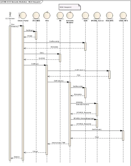
Figure 8. Sequence diagram for generating the NGA viewpoint 48
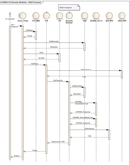
Figure 9. Sequence diagram for generating the USGS viewpoint 51
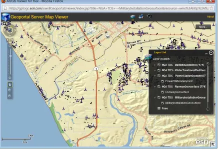
Figure 10. A portrayal of some of the harmonized data through the ESRI client 52
Figure 11. A combination of unmodified and harmonized data presented through the
Compusult client 53
Figure 12. Harmonization process using the CMM 55
Figure 13. Visualization of TDS and Harmonized TNM Road networks using Envitia
Figure 14. Attributes for sample features of the TDS and harmonized TNM datasets 57
OGC
®OWS-8 CCI Semantic Mediation Engineering Report
1 Introduction
1.1 Scope
The OWS-8 Cross Community Interoperability (CCI) thread built on progress made in the recent OWS-7 initiative to cover key technology areas that could not be addressed within the scope of that initiative. The OWS-8 CCI thread aimed to increase
interoperability within communities sharing geospatial data, including advancing of interoperability among heterogeneous data models, advancing strategies to share styles to provide a more common and automated use of symbology, improvement of KML, and advancing schema automation allowing communities to better share their information artefacts. This OGC engineering report aims to present findings from CCI thread activities towards advancement of semantic mediation involving data retrieved from heterogeneous data models that are available through web services conformant to OGC standards.
The engineering report will briefly introduce relevant details of the semantic web and mediation. The document will make recommendations on establishing a semantic mediation architecture that uses OGC web services and emerging practice from the semantic web community. Based on the scenario adopted by the CCI thread, the document will also discuss the pros and cons of adopting relevant standards. The engineering report will offer recommendations on how specific OGC standards may be adopted or modified in order to support semantic mediation.
1.2 Document contributor contact points
All questions regarding this document should be directed to the editor or the contributors:
Name Organization
Gobe Hobona Envitia Ltd. Roger Brackin Envitia Ltd.
Luis Bermudez Open Geospatial Consortium Robin Houtmeyers Luciad
Daniel Balog Luciad
Rob Cass Compusult
Clemens Portele interactive instruments GmbH Paul Birkel Mitre/NGA
Teddy Matinde ESRI
1.3 Revision history
Date Release Editor Primary clauses
modified
Description
2011/05/25 0.0.1 GH,RB All Initial writing
2011/06/23 0.0.2 GH,RB 5.2, 9.5 Added the GeoSPARQL summary and the mapping actions discussion
2011/06/23 0.0.2 RL,DB 11 Added the discussion on the semantic mediator 2011/06/23 0.0.2 LB 6.1,6.2,7 Various edits
2011/06/24 0.0.2 RC 12 Added the resource discovery and catalogue service discussion
2011/08/31 0.0.3 RL,DB 11 Extended discussion on the semantic mediator 2011/08/31 0.0.3 GH,RB All Editorial revision
2011/08/31 0.0.4 DB 9.2, 11 Extended details on semantic mediator 2011/09/15 0.0.6 GH 13.2, Appendix A Inserted Compusult client screenshot. Added
Appendix A.
1.4 Forward
Attention is drawn to the possibility that some of the elements of this document may be the subject of patent rights. The Open Geospatial Consortium Inc. shall not be held responsible for identifying any or all such patent rights.
Recipients of this document are requested to submit, with their comments, notification of any relevant patent claims or other intellectual property rights of which they may be aware that might be infringed by any implementation of the standard set forth in this document, and to provide supporting documentation.
2 References
The following documents are referenced in this document. For dated references, subsequent amendments to, or revisions of, any of these publications do not apply. For undated references, the latest edition of the normative document referred to applies. Berners-Lee T., (2006). Notation 3, available from
http://www.w3.org/DesignIssues/Notation3.html
Envitia,(2011). Geospatial Intelligence Integrated Reference Architecture (GI2RA), available from
http://www.envitia.com/admin/uploads/pagedownloads/live/384/UTP1149-%20GI2RA%20Interoperability%20UTP1149-01.pdf
http://inspire.jrc.ec.europa.eu/documents/Network_Services/JRC_INSPIRE-TransformService_TG_v3-0.pdf
HP, Jena – A Semantic Web Framework for Java, available from
http://jena.sourceforge.net
ISO,(2005). ISO 19119: Geographic information – Services
ISO,(2005). ISO 19109: Geographic information – Rules for Application Schema ISO,(2010). ISO 19763: Information technology – Metamodel framework for interoperability (MFI) – Part 3: Metamodel for ontology registration
ISO,(2005). ISO 19110: Geographic information – Methodology for feature cataloguing ISO,(2009). N 2705: Report from stage 0 Project 19150 Geographic information – Ontology
ISO, (2010). ISO/IEC FDIS 19763-3 Information technology - Metamodel framework for interoperability (MFI) Part 3: Metamodel for ontology registration 2nd Edition
OASIS, (2005). ebXML Registry Information Model (RIM) v3.0 Standard OGC 03-040, OGC Reference Model (ORM), 2003-09-16, available from
http://portal.opengeospatial.org/files/?artifact_id=3836
OGC 06-121r3, OpenGIS® Web Services Common Standard, 2007-02-09, available from
http://portal.opengeospatial.org/files/?artifact_id=20040
OGC 07-160r1, OGC® OWS-5 Conflation Engineering Report, 2008-09-12, available from http://portal.opengeospatial.org/files/?artifact_id=30064
OGC 09-048r3, Name type specification – definitions – part 1 – basic name, 2010-03-31, available from http://portal.opengeospatial.org/files/?artifact_id=37802
OGC 09-138, Fusion Standards Study Engineering Report, 2010-03-2, available from
http://portal.opengeospatial.org/files/?artifact_id=36177
OGC 10-184, Fusion Standards Study, Phase 2 Engineering Report, 2010-12-13, available from http://portal.opengeospatial.org/files/?artifact_id=41094
OGC 11-052r3, GeoSPARQL - A geographic query language for RDF data, 2011-07-02, available from http://portal.opengeospatial.org/files/?artifact_id=44722
3 Terms and definitions
3.1
conflation
the process of unifying multiple separate sources of data into one integrated all-encompassing result
3.2
data fusion
the act or process of combining or associating data or information regarding one or more entities considered in an explicit or implicit knowledge framework to improve one’s capability (or provide a new capability) for detection, identification, or characterization of that entity
3.3
feature
representation of some real world object or phenomenon 3.4
interoperability
capability to communicate, execute programs, or transfer data among various functional units in a manner that requires the user to have little or no knowledge of the unique characteristics of those units [ISO 19119]
3.5
metadata
data about data 3.6
model
abstraction of some aspects of a universe of discourse [ISO 19109] 3.7
ontology
a formal specification of concrete or abstract things, and the relationships among them, in a prescribed domain of knowledge [ISO/IEC 19763]
4 Conventions
4.1 Abbreviated terms
CCI Cross Community Interoperability
ER Engineering Report
GIS Geographic Information System
OASIS Organization for the Advancement of Structured Information Standards
OGC Open Geospatial Consortium
OWL Web Ontology Language
OWS OGC Web Service
OWS-8 OGC Web Services Initiative, Phase 8 NSG National System for Geospatial-Intelligence RDF Resource Description Framework
TDS Topographic Data Store
TNM The National Map
SDI Spatial Data Infrastructure
SKOS Simple Knowledge Organization System SOA Service Oriented Architecture
SRS Spatial Reference System
SSA Shared Situational Awareness
URL Uniform Resource Locator
URN Uniform Resource Names
USGS United states Geological Survey
WFS Web Feature Service
WMS Web Map Service
WS Web Service
XML eXtensible Markup Language
5 Background Information
5.1 Geographic Features
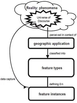
A fundamental unit of geographic information is a feature. The OGC Reference Model (ORM) states that “a feature is an abstraction of a real world phenomenon. A geographic feature is a feature associated with a location relative to the Earth. A digital representation of the real world can be thought of as a set of features” [OGC 03-040]. This approach to modeling geographic features is consistent with the international standard ISO 19110 which provides a standard framework for organizing and reporting the classification of features and ISO 19109 which gives rules for creating application schemas. Together, these standards provide the principles for the definition of features. An illustration of the process of abstraction from reality to feature instances is presented in Figure 1. As illustrated, phenomena in the real world are classified into feature types which are then instantiated as features.
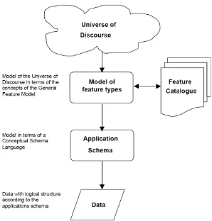
Figure 2 shows the OGC approach to modeling geographic features. The approach provides conceptual schemas that define abstract feature types and provide the foundation for domain experts to develop application schemas that are used to capture data about feature instances.
An application schema is a set of conceptual schema for data required by one or more applications. The application schema contains instances of types defined in the general feature model. For example, the general feature model defines the concept of feature type while an application schema defines specific feature types such as Road or Lake. The set of feature types defined for an information community are presented in a feature catalogue.
Figure 1. The process from universe of discourse to data (ISO 19109)
Figure 2. Modeling Geographic Information (ISO 19109)
5.2 OGC Fusion Standards Study
As part of the concept preparation of the recent OWS-7 initiative, the OGC conducted a Fusion Standards Study [OGC 09-138]. The goal of the study was to define and develop fusion standards to give analysts an environment where they can use interoperable tools to analyze, process and exploit two or more different types of data or products from the same or multiple sensors and databases from one client. Some of the objectives of the study were to develop new capabilities or exploit current capabilities for fusing information from multiple sensors, from multiple sources, and from multiple INTs in ways that dramatically improve the ability to detect, identify, locate, and track objects. The study examined sensor fusion, object/feature fusion and decision fusion. The following recommendations from both Phases 1 and 2 of the object/feature fusion component of the study have been identified as relevant to semantic mediation:
1. Define a conceptual model of feature lifecycle – beyond conflation (from Phase 1) 2. Standardize metadata for provenance and uncertainty (from Phase 1)
4. Define a portfolio of feature fusion services (from Phase 1) 5. Develop WPS Profiles for Geoprocessing Fusion (from Phase 2)
6. Further develop rule-based geoprocessing to an OGC Best Practice (from Phase 2)
7. Registries for Object/Feature Fusion (from Phase 2)
5.3 OGC GeoSPARQL Standard
The GeoSPARQL standard, which supports representation and querying of geospatial data on the Semantic Web, is currently under development within the OGC. GeoSPARQL defines a vocabulary for representing geospatial data in RDF, and it defines an extension to the SPARQL query language for processing geospatial data. The GeoSPARQL specification comprises several different components. A core component defines top-level RDFS/OWL classes for spatial objects. A geometry component defines RDFS data types for serializing geometry data, RDFS/OWL classes for geometry object types, geometry-related RDF properties, and non-topological spatial query functions for geometry objects. A geometry topology component defines topological query functions. A topological vocabulary component defines RDF properties for asserting topological relations between spatial objects, and a query rewrite component defines rules for transforming a simple triple pattern that tests a topological relation between two features into an equivalent query involving concrete geometries and topological query functions. The OWS-8 CCI activity was an early adopter of the draft GeoSPARQL standard. Consequently, some aspects of the draft standard that have been included in OWS-8 may already be obsolete at the time of publishing this Engineering Report.
5.4 OWS-5 Data Conflation
5.5 UK MoD GI2RA
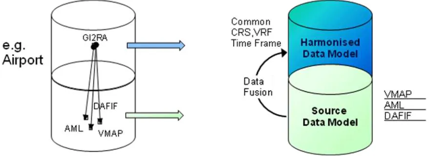
In 2007 the United Kingdom Ministry of Defence (MoD) awarded Envitia (formerly known as TENET Technology Ltd) a three year research project, Geospatial Intelligence Integrated Reference Architecture (GI2RA), to investigate the future provision and dissemination of environmental or geospatial information and intelligence. A component within GI2RA involved information modeling and data harmonization. A harmonized data model was developed based on various defense formats such as Additional Military Layers (AML), Digital Aeronautical Flight Information File (DAFIF) and NGA Vector Map (VMAP). Using the Envitia Content Model Mapper (CMM), the feature types and attributes from the source data models were then mapped to the harmonized data model.
Figure 3. Concept view of the GI2RA harmonization and fusion process
6 CCI Source Data
In this section a brief description of the source datasets supplied by the thread sponsors is presented.
6.1 NGA Topographic Data Store
environment, aircraft facility, boundaries, hydrography, transportation, vegetation, agricultural, cultural, inlandwater, population and information.
<xsd:schema xmlns:xsd="http://www.w3.org/2001/XMLSchema"
xmlns:gml="http://www.opengis.net/gml" type="tds:RailwayGeocurveType" />
<xsd:complexType name="RailwayGeocurveType"> <xsd:complexContent>
<xsd:extension base="gml:AbstractFeatureType"> <xsd:sequence>
<xsd:elementname="geometry"
type="gml:CurvePropertyType" />
<xsd:element name="facilityOperationalStatus"> <xsd:simpleType>
<xsd:restriction base="string"> <xsd:enumeration
value="continuous" />
<xsd:enumeration
value="noInformation" />
<xsd:enumeration
value="notInOperation" />
6.2 USGS The National Map
The National Map (TNM) is a collaborative effort among the USGS and other Federal, State, local, and Tribal partners to improve and deliver topographic information for the Nation. With applications ranging from recreation to scientific analysis to emergency response, the National Map is one of the most comprehensive topographic data products available. The USGS publishes the National Map through web services that include online viewers and downloadable data. The geographic information available from The National Map includes orthoimagery (aerial photographs), elevation, geographic names, hydrography, boundaries, transportation, structures, and land cover. The National Map website allows for downloading data in a variety of formats include shapefiles, ESRI personal geodatabases (version 9.1 and version 10).
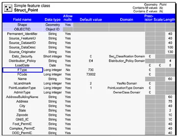
Figure 4. Table structure of the TNM Struct_Point class (source: USGS)
The original TNM model is designed as a relational database. Each of its relational tables contains multiple feature types that share the same table structure. For example, the TNM relational table Struct_Point contains feature types for health facilities, education facilities, emergency service facilities and others. As illustrated in Figure 4, a record in the table describes an instance of the feature type indicated by the ‘FType’ property. This approach differs from that of the TDS which has all records in a feature collection belonging to the same feature type. For OWS-8, it was decided to extract some of the feature types into independent feature types in order to make the conceptual model of the TNM more apparent. The rest of this report refers to this revised model of the TNM. Enumerations within the TNM are modeled as shared codelists that are reusable between multiple feature properties. This means that the TNM model does not repeat definitions of enumerations. Although, use of shared codelists between different feature properties is more efficient it was observed that WFS DescribeFeatureType responses are not able to reference shared codelists, by virtue of their XSD encoding. Therefore, in order to describe codelists for the TNM model through a WFS DescribeFeatureType response, the same approach used by the TDS would need to be adopted.
Another difference between enumerations for TNM and TDS feature properties is that enumerations for TNM properties are made up of a codelist value that is typically numeric and a label in natural language. In contrast, the enumerations for TDS properties are made up of labels in natural language only. This presents a challenge for any WFS attempting to present TNM codelists. Specifically, only the TNM codelist values would be presentable through the xsd:enumeration axiom.
7 CCI Architecture
Figure 5. CCI Architecture
7.1 Component Implementations
Participants of the CCI thread provided the following components in order to implement the CCI architecture:
Web GUI Clients provided by Compusult and ESRI
CSW Services provided by Compusult
CSW-ebRIM Portrayal Registry provided by Carmenta
FPS provided by Carmenta
WFS USGS provided by CubeWerx
WFS NGA provided by Interactive Instruments GmbH
Semantic mediator provided by Luciad
Knowledge Base and SPARQL server provided by Envitia Ltd.
8 Semantic Mediation Approach
As illustrated in the architecture diagram, there are at least two source datasets and each dataset has an ontology associated with its data model. The semantic mediator uses a common model to mediate between the two (or more source models). The following approaches were identified as candidate formulae for defining the common model:
Option 1: Create a new common model
A new RMM would be created as the intersection of the NGA and USGS models
NGA model would map to the RMM.
USGS model would map to the RMM.
Option 2: Use NGA Model as the Common Model
The common model for this thread would be the NGA model, since it has portrayal symbols and rules already defined for some feature types
The USGS model would be mapped to the common model, i.e. the NGA model in this case.
Two WFS services would be available from the semantic mediator services
o WFS based on NGA model serving NGA data
Option 3: Use NGA Model as starting point for the Common Model augmented as needed from USGS model.
The common model for this thread, referred to as the Surrogate RMM (RMM-S), would be based on the TDS model
Mapping to be done are as follows:
o TNM -> RMM-S
o TDS -> RMM-S
o RMM-S -> TNM
o RMM-S-> TDS
Four WFS services would be available:
1. WFS based on NGA TDS model serving NGA data - provided directly by NGA
2. WFS based on NGA TDS model serving USGS data - provided by semantic mediator
3. WFS based on USGS TNM model serving NGA data - provided by semantic mediator
4. WFS based on USGS TNM model serving USGS data - provided directly by USGS
The CCI thread selected Option 3, which defines a common model as the NGA TDS model augmented by that subset of the USGS TNM model that is not covered by the TDS.
8.1 Semantic Description of Data Models
A key difference between the representation of properties in GML schema compared to representation in RDF is that feature properties in GML are defined within the scope of a feature type through xsd:element declarations. In contrast, properties in OWL are independent of an owl:Class. An association between a property and a class in OWL is made through the rdfs:domain axiom. For a single property one can have declare multiple rdfs:domain axioms. However, multiple properties may have the same name but different restrictions if the properties belong to different feature types. Therefore it was necessary to qualify each property in OWL with the name of the feature type to which it belongs. Following the recommendation from the ISO TC 211 project 19150 that “the property name shall be composed of the class name and the attribute name using the dot (.) notation”, a convention was adopted where each xsd:element entry is represented by an individual owl:DatatypeProperty [ISO TC 211 N 2705].
Consequently, the following formula was designed:
Each ontology should be described using an owl:Ontology axiom with minimal metadata provided by dc:title, owl:versionInfo, dc:date and dc:description properties.
Each feature type should have the 'Feature' rdfs:Class from GeoSPARQL as a superclass.
Each feature type should reference its parent ontology through an rdfs:isDefinedBy property that references the resource identifier(URI) of the parent ontology.
For each feature type, create an owl:Class representing the concept abstracted by the feature type.
For each feature property, create an owl:DatatypeProperty for relations between instances of classes and XML Schema datatypes. Alternatively create an owl:ObjectProperty for relations between instances of classes. The owl:DatatypeProperty or owl:ObjectProperty should have a name with a dot-separated concatenation of the feature type name and the property name. For example, FeatureTypeName.PropertyName.
For each feature property, use rdfs:domain and rdfs:range to associate the property to a feature type.
For each feature type or property, use dc:source for the qualified logical name with the convention {BaseURI}#FeatureTypeName.PropertyName.
For each feature type or property, use dc:description to encode the description in natural language(i.e. Dublin Core).
For each feature type include a hasGeometry or its sub-property, defaultGeometry, inherited from GeoSPARQL.
For each codelist or enumeration, a SKOS representation of the codelist should be provided.
The following extract presents an example declaration of an ontology.
<owl:Ontology rdf:about=""> <owl:versionInfo
rdf:datatype="http://www.w3.org/2001/XMLSchema#string" >0.3</owl:versionInfo>
<dc:date
rdf:datatype="http://www.w3.org/2001/XMLSchema#da te">2011-08-04</dc:date>
<dc:description
rdf:datatype="http://www.w3.org/2001/XMLSchema#str ing">Topographic Data Store Geodatabase Schema: This geodatabase schema defines the logical content for Topographic Feature Data in the U.S. National System for Geospatial-Intelligence (NSG). </dc:description>
<dc:title>NGA TDS ontology</dc:title>
<owl:imports
rdf:resource="http://env032011.appspot.com/geosparql. rdf" />
</owl:Ontology> </rdf:RDF>
The following extract presents an example representation of a feature type.
<owl:Class about="http://metadata.dod.mil/mdr/ns/GSIP/3.0/tds/3.0#RailwayGeocurve"> <rdfs:label xml:lang="en">Railway Geospatial Curve</rdfs:label>
<rdfs:subClassOfresource="http://env032011.appspot.com/geosparql.rdf#Feature" /> <rdfs:subClassOf>
<owl:Restriction> <owl:onProperty
resource="http://env032011.appspot.com/geosparql.rdf#defaultGeometry" /> <owl:allValuesFromresource="http://env032011.appspot.com/geosparql.rdf#Curve" />
</owl:Restriction> </rdfs:subClassOf>
<dc:description datatype="http://www.w3.org/2001/XMLSchema#string">Railway
Geospatial Curve: One or more railway tracks comprising a network that is operated for the conveyance of passengers and/or goods</dc:description>
<dc:relation datatype="http://www.w3.org/2001/XMLSchema#anyURI">
urn:ogc:ows8:cci:topicCategory:Transportation</dc:relation> <rdfs:isDefinedBy rdf:resource=" "/>
</owl:Class>
The following extract presents an example representation of a feature property.
<owl:DatatypeProperty about="http://metadata.dod.mil/mdr/ns/GSIP/3.0/tds/3.0# RailwayGeocurve.facilityOperationalStatus">
<rdfs:label xml:lang="en">
Railway Geospatial Curve : Facility Operational Status</rdfs:label>
<dc:description datatype="http://www.w3.org/2001/XMLSchema#string">
Railway Geospatial Curve : Facility Operational Status:
<skos:definitionresource="http://metadata.dod.mil/mdr/ns/GSIP/3.0/tds/3.0# RailwayFacilityOperationalStatusType" />
<rdfs:domainresource="http://metadata.dod.mil/mdr/ns/GSIP/3.0/tds/3.0# RailwayGeocurve" />
<rdfs:rangeresource="http://www.w3.org/2001/XMLSchema#string" />
</owl:DatatypeProperty>
The following extract presents an example representation of a codelist.
<skos:ConceptScheme about="http://metadata.dod.mil/mdr/ns/GSIP/3.0/tds/3.0# RailwayFacilityOperationalStatusType">
<typeresource="http://www.w3.org/2002/07/owl#Thing" />
<skos:prefLabel datatype="http://www.w3.org/2001/XMLSchema#string">
Railway Facility Operational Status Type</skos:prefLabel>
<skos:definition datatype="http://www.w3.org/2001/XMLSchema#string">
Railway Facility Operational Status Type: A coded domain value denoting the facility operational status type of a railway.</skos:definition>
</skos:ConceptScheme>
The following extract presents an example representation of a codelist value.
<skos:Concept about="http://metadata.dod.mil/mdr/ns/GSIP/3.0/tds/3.0# RailwayFacilityOperationalStatusType_continuous">
<typeresource="http://www.w3.org/2002/07/owl#Thing" />
<skos:prefLabel datatype="http://www.w3.org/2001/XMLSchema#string">
Continuous</skos:prefLabel>
<skos:definition datatype="http://www.w3.org/2001/XMLSchema#string">
Continuous: Operating without interruption.</skos:definition>
<skos:altLabel datatype="http://www.w3.org/2001/XMLSchema#string">
continuous</skos:altLabel>
<skos:inSchemeresource="http://metadata.dod.mil/mdr/ns/GSIP/3.0/tds/3.0# RailwayFacilityOperationalStatusType" />
</skos:Concept>
Clients querying the SPARQL server were then able to compose queries based on the following example:
9 Semantic Mappings
Upon reviewing the feature types from the source datasets, it was observed that there potentially would be a variety of mapping scenarios for feature types. These included:
No mapping: source feature type has no suitable match in target
One-to-one: source feature type has one suitable match in target; all instances of the source feature type should be mapped as instances of the target feature type
One-to-many: source feature type matches with more than one target feature type. In this case, the value of one or more properties determines which the target feature type is for a certain source instance
Many-to-One: source feature type matches with one target feature type. However, there are other source feature types that also map to that target feature type. When transforming data from source to target, one or more properties should get a fixed value.
Similarly it was observed that feature properties would exhibit similar mapping scenarios. These included:
Direct mapping: the property value of the source feature is directly used as the property value of the target feature
No mapping: the source property has no suitable match in the target feature type
Codelist mapping; Between codelists it was also observed that there could be:
o Direct value mapping: one source code list value maps directly on one target code list value
o No mapping: source code value has no suitable value in the target code list. In order not to lose information, the recommendation seems to be to put the value of the source code in some free TXT attribute (if available) of the target type
o Many-to-one : multiple source code list values are mapped on a single target code list value
9.1 Ontology Mapping versus Transformation Rules
property. For example, although all referring to distance, the following source properties would require different conversion factors to transform them into the target property:
Source Property A Target Property C
(Distance in Metres) (Conversion Factor 1) (Distance in Miles)
Source Property B Target Property D
(Distance in Yards) (Conversion Factor 2) (Distance in Miles)
A more complex transformation could be where conditional mappings (If...Then...Else) apply. The question for the CCI thread was how much of the data transformation mappings should be standardized and how much should be left to implementations. One option is to have the semantic mediator ‘decide' on the appropriate transformation to use for specific semantic matches. Another option is to use a ‘rule' language to define the appropriate transformation. There are multiple rule languages available that could be used to standardize transformation mappings, some of the examples include RIF and SPIN.
There are multiple possible approaches for describing mappings and rules within semantic mediation. For OWS-8, the CCI thread considered ontology mapping and transformation rules. This section describes these approaches.
9.1.1 Ontology Mapping
In this approach, the knowledge base provides (next to the ontologies) semantic information on how an ontology is mapped onto another ontology. The mediator uses this information from the knowledge base to create a set of object transformations that are able to transform GML features from one schema to another. In addition, the mediator also creates a set of filter transformations that can transform the OGC filter instances that are used to limit the results of WFS feature requests.
In essence, this approach simply names the semantic match between classes. The semantic mediator then applies an appropriate transformation based on the semantic match that is defined in the ontology. Some of the RDF, OWL and SKOS properties identified as applicable within this approach include skos:exactMatch, skos:closeMatch, owl:equivalentProperty and owl:equivalentClass.
9.1.2 Transformation Rules
In this approach, the knowledge base provides a set of rules (next to the ontologies) that can be used to transform instances. The mediator enters these rules in an inference engine. To transform data, the mediator transforms the source GML features into RDF and feeds that into the inference engine. The transformation rules in the inference engine then ensure that a new set RDF rules is created that represents the instance in the target model. The mediator extracts that instance, converts it into GML and puts it in the resulting feature collection.
A rule is defined as a combination of an antecedent (body) and a consequent (head). Typically, a rule implies that if the antecedent is true then the consequent has to be true. Both the antecedent and the consequent may contain zero or more atomic statements. In first order logic, an atomic statement (also called an ‘atom’) is a statement that cannot be broken down. The presence of multiple atoms in an antecedent or consequent is interpreted as a conjunction of the atoms. Each atom is defined as a statement consisting of a triple. For example, where the symbol ● represents a conjunction between two atoms; and represents the implication of the antecedent, the following is implied: if an entity A is the capital of entity B and the entity A has an airport called “Heathrow”, then the entity B should have the name “United Kingdom”.
(A capitalOf B ● A hasAirport “Heathrow” ) (B hasName “United Kingdom”)
RDF, OWL and SKOS are collections of triples, without the explicit definition of implications. Consequently, several rule languages have been developed for the semantic web. Examples include the JenaRules, Rule Interchange Format (RIF), N3 Logic and the SPARQL Inferencing Notation (SPIN). Across all the aforementioned rule languages, the basic form of antecedent and consequent is consistent. What differs is the expressivity and syntax adopted by each language for integrating statements.
For semantic mediation, a rule-based mechanism would need to support the use of the ontologies describing the feature types of the source datasets. Moreover, such an approach would also need to specify transformations to apply to specific objects from the source data models. Several options for the encoding of the rules were considered. These included:
Rule Interchange Framework (RIF)
N3 Logic Rules
JenaRules
SPARQL CONTRUCT queries
9.1.2.1 Rule Interchange Format
The Rule Interchange Format (RIF) is a W3C Recommendation. RIF is a family of rule languages, called dialects, with rigorously specified syntax and semantics. RIF dialects can be classified into two groups: logic-based dialects and dialects for rules with actions. The logic-based dialects include languages that employ some kind of logic, such as first-order logic (often restricted to Horn logic). The rules-with-actions dialects include production rule systems, such as Drools, as well as event-condition-action rules, such as Reaction RuleML. Currently the only two logic dialects within RIF are the Basic Logic Dialect (RIF-BLD) and the RIF Core Dialect. The only rules-with-actions dialect defined within RIF is the
Production Rule Dialect (RIF-PRD).
RIF dialects include:
Basic Logic Dialect (BLD): BLD is designed to be simple. A BLD document consists of a number of rules. Each rule contains a set of Horn rules; existential qualification is supported, negation is not. RIF-BLD has a number of syntactical extensions to support features such as objects and frames. The main semantic extensions include datatypes and externally defined predicates.
Production Rule Dialect (PRD): This is one of the major dialects of RIF, influenced by production rule technology that has been demonstrated by major software vendors. Production rules, as they are currently practiced in main-stream systems like Jess or JRules, are defined using ad-hoc computational mechanisms, which are not based on logic. For this reason, RIF-PRD is not part of the suite of logical RIF dialects and stands apart from them. However, significant effort has been extended to ensure interoperability with the other dialects where possible.
Core Dialect (Core): This dialect is a subset of both RIF-BLD and RIF-PRD based on RIF-DTB 1.0, thus enabling limited rule exchange between logic rule dialects and production rules. RIF-Core corresponds to Horn logic without function symbols (often called 'Datalog') with a number of extensions to support features such as objects and frames as in F-logic, internationalized resource identifiers for concepts, and XML Schema datatypes.
Datatypes and Built-Ins (DTB): This specification lists the datatypes, built-in functions and built-in predicates expected to be supported by RIF dialects such as the RIF-Core, RIF BLD and RIF PRD.
The following are examples of the use of RIF within the geospatial community.
OGC GeoSPARQL: In the latest revision of the GeoSPARQL draft standard, dated April 13th 2011, the OGC adopts RIF for describing query transformation rules. The GeoSPARQL draft standard provides a RIF template rule that is applied to features imported from an RDF document. The template example describes a rule for testing if two features are related.
9.1.2.2 N3 Logic
N3 Logic offers a notation for encoding triples and the inference rules [Berners-Lee, 1998]. It is designed to be compact and more readable than RDF's XML syntax. It is also designed to be more expressive than RDF. N3 has several subsets including NTriples, Turtle, N3 RDF and N3 Rules. N-Triples is a line-based, plain text format for representing correct answers to RDF/XML test cases. Turtle allows writing down an RDF graph in a compact textual form. N3 RDF offers a constrained language such that only correct RDF graphs can be defined. N3 Rules offers a language for defining rules with both an antecedent and consequent. Of the Rule languages under examination in OWS-8, N3 is one of the most mature and hence there are free and open source implementations available. One such implementation is Euler which is available in Java, C#, Python and other languages.
9.1.2.3 JenaRules
An alternative to the aforementioned approaches is to use JenaRules , supported by the Jena API [HP]. Jena is a Java library for handling RDF and provides the foundation for several Java-based semantic web applications such as ARQ, Pellet and others. Jena allows for
querying, writing and reasoning over an RDF graph. The syntax and grammar of JenaRules is based on N3.
9.1.2.4 SPARQL CONSTRUCT
SPARQL is a language developed for querying RDF-encoded triple stores. It is a Recommendation of the W3C. It supports querying of triple patterns with conjunctions, disjunctions, value filters, and optional patterns. A separate W3C recommendation describes an XML format for the results returned by a SPARQL query. SPARQL results can be
returned, alternatively, encoded in RDF. SPARQL offers a SELECT form which can be used to return a subset of the triple store. SPARQL also offers a CONSTRUCT query which returns an RDF graph formatted according to a graph template. The returned graph is formed by substituting the variables in the graph template with the subject, predicate or objects from the returned triples. The CONSTRUCT form is functionally equivalent to logical rules in that the construct template is equivalent to a consequent(head) and the WHERE clause equivalent to the antecedent(body). The following screenshots show the SPARQL queries equivalent to those presented in the N3 rule examples above. The only difference is that the N3 rules are provided in a single document, whereas the SPARQL queries are documented as separately.
9.1.2.5 SPARQL Inferencing Notation (SPIN)
spin:constraint can be used to define conditions that all members of a class must fulfill. spin:rule can be used to specify inference rules using SPARQL CONSTRUCTs and DELETE/INSERTs. A spin:constructor can be used to initialize new instances with default values. In addition to these class description properties, SPIN provides a meta-modeling capability that can be used to build a modeling language and SPARQL extensions. The meta-modeling capabilities provide the ability to encapsulate reusable SPARQL queries into templates, and to derive new SPARQL functions as well as magic properties from other SPARQL queries and functions. TopQuadrant offers an open source API for SPIN.
SPIN inherits it rule capabilities from SPARQL. The key benefit of SPIN is from its ability to persist rules within the data the rules apply to. Therefore for the purpose of OWS-8, the compact nature of alternative rule languages such as N3 and JenaRules outweighs this benefit of SPIN.
9.2 Selected Approach for Semantic Mappings
After careful consideration of the various approaches for transformation rules and the ontology mappings approach, the ontology mappings approach was selected as most appropriate for the OWS-8 CCI work. The main reasoning behind this was because the ontology approach would allow the semantic mediator to create inverse filter mappings for queries to the source WFS. Filtered queries to the source WFS result in better performance as the source WFS has to return less feature instances during GetFeature requests.
In order to specify the ontology mappings, a structure for Microsoft Excel spreadsheets and an RDF documents was designed. This section describes the spreadsheet and RDF encoding for mappings.
Each worksheet in the mappings spreadsheet contains the following columns:
sourceFeatureType: This is the natural name of the source feature type.
sourceProperty: This is the natural name of a source feature property.
sourceEnumerant: This is a value in a source codelist or enumeration.
action1: Describes a type of mapping between the source and target objects.
action2: Describes another type of mapping between the source and target objects.
targetFeatureType: This is the natural name of the target feature type.
targetProperty1 : This is the natural name of the target feature property.
targetEnumerant1: This is a value in a target codelist or enumeration.
targetLiteralValue1: This is a literal value to be assigned to a target feature property.
targetProperty2 : This is the natural name of another target feature property.
targetLiteralValue2: This is a literal value to be assigned to another target feature property.
Based on the values in these columns, an RDF document can be encoded with a single row in the spreadsheet decomposed into two mapping specifications. One mapping specification describes how the source property relates to the first target property; the other mapping specification describes how the source property relates to the second target property. This ‘decomposition’ allows for any number of target properties to be assigned to a single source property. For rapid conversion from Excel to RDF, it is recommended that the columns in the spreadsheet be duplicated, with the duplicates offering resource identifiers (URLs) from the USGS and NGA ontologies. The following extracts show an RDF encoding of a single row from the Excel spreadsheet. It should be noted that the target enumerant and literal value are represented in the same RDF property, namely ows8:targetValue.
<ows8:Mapping rdf:about="http://env032011.appspot.com/ows8.rdf#mapping_206_1"> <rdf:typerdf:resource="http://www.w3.org/2002/07/owl#Thing" />
<ows8:mappingTyperdf:resource="http://env032011.appspot.com/ows8.rdf# sameAsEnumerant" />
<ows8:targetFeatureTyperdf:resource="http://env032011.appspot.com/rmm.rdf# InlandWaterbodyGeosurface" />
<ows8:targetPropertyrdf:resource="http://env032011.appspot.com/rmm.rdf# InlandWaterbodyGeosurface.waterResourceInfo.hydrologicPersistence" />
<ows8:targetValuerdf:resource="http://env032011.appspot.com/rmm.rdf# InlandWaterbodyWaterResourceInfoHydrologicPersistenceType_perennial" />
<ows8:sourceFeatureTyperdf:resource="http://www.usgs.gov/projects/ows8# LakePondGeosurface" />
<ows8:sourcePropertyrdf:resource="http://www.usgs.gov/projects/ows8# LakePondGeosurface.featureCode" />
<ows8:sourceValuerdf:resource="http://www.usgs.gov/projects/ows8# NhdWaterbodyFeatureCodeType_lakePondIntermDateOfPhoto" />
</ows8:Mapping>
<ows8:Mapping rdf:about="http://env032011.appspot.com/ows8.rdf#mapping_206_2"> <rdf:typerdf:resource="http://www.w3.org/2002/07/owl#Thing" />
<ows8:targetValue>NHD: Lake/Pond: Hydrographic Category = Perennial; Stage = Date of Photography</ows8:targetValue>
<ows8:mappingTyperdf:resource="http://env032011.appspot.com/ows8.rdf# sameAsEnumerant" />
<ows8:targetFeatureTyperdf:resource="http://env032011.appspot.com/rmm.rdf# InlandWaterbodyGeosurface" />
<ows8:targetPropertyrdf:resource="http://env032011.appspot.com/rmm.rdf# InlandWaterbodyGeosurface.note.memorandum" />
<ows8:sourceFeatureTyperdf:resource="http://www.usgs.gov/projects/ows8# LakePondGeosurface" />
<ows8:sourcePropertyrdf:resource="http://www.usgs.gov/projects/ows8# LakePondGeosurface.featureCode" />
<ows8:sourceValuerdf:resource="http://www.usgs.gov/projects/ows8# NhdWaterbodyFeatureCodeType_lakePondIntermDateOfPhoto" />
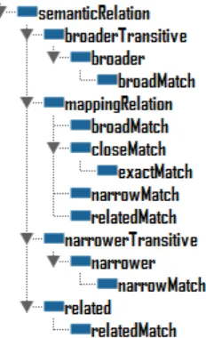
The CCI thread also considered whether RDF, OWL and SKOS could enable the specification of semantic matches and the required data transformation function. It was observed that RDF, OWL and SKOS have a limited vocabulary for describing semantic relationships between objects. For example, SKOS offers 14 semantic relation types, i.e. those that inherit directly or indirectly from skos:semanticRelation. The semantic relation types describe the degree to which the meanings of two objects are similar. For discovery purposes, such semantic relationships are adequate. However, for semantic mediation involving data remodeling, additional information is required to enable a mediator to apply an appropriate conversion to input data. It was concluded that RDF, OWL and SKOS did not offer a vocabulary expressive enough to describe data transformation.
Figure 6. Semantic relation hierarchy of SKOS
A vocabulary of actions to apply to source properties was provided in the OWS-8 CCI mappings spreadsheet. The vocabulary addresses limitations of the properties offered by OWL and SKOS. Specifically, the vocabulary of action types offers a mixture of semantic relations and transformation types. The following values are offered by the vocabulary:
convertKMtoM: Specifies conversion from kilometers to meters.
convertKM2toM2: Specifies conversion from square kilometers to square meters. firstComponentOf: Specifies that the value of a property should be the first in a collection.
secondComponentOf: Specifies that the value of a property should be the second in a collection.
fourthComponentOf: Specifies that the value of a property should be the fourth in a collection.
fifthComponentOf: Specifies that the value of a property should be the fifth in a collection.
generalizeEnumerant: Specifies that the domain of a property is a generalization of another.
sameAsEnumerant: Specifies that an enumerant (i.e. codelist value) is the same as another enumerant (from a different codelist). This mapping type is different from the owl:sameAs and skos:exactMatch constructs because it can be used to
associate enumerants declared as skos:Concept constructs to literal values that have not been declared in the ontology.
sameAsProperty: Specifies that two properties from different feature types refer to the same characteristic, although the properties may hold different values. This mapping type is different from the owl:equivalentProperty construct which is used to state that two properties have the same property extension (i.e. they hold the same “values”). This mapping type applies to both geometric and alphanumeric properties.
replace: Specifies that a target property or enumerant is a replacement of a source property or enumerant respectively. This relation may only be used if the source and target constructs do not mean the same thing although serving a similar purpose. For example, the source enumerant “unknown” may relate to the target enumerant “not applicable” through a “replace” mapping; however, source enumerant “NA” would relate to the target enumerant “not applicable” through a “sameAsEnumerant” mapping.
In a scenario where a user requests an NGA RailwayGeocurve, the semantic mediator would send the following request to the knowledge base:
DESCRIBE ?a WHERE
{
?a <http://www.w3.org/1999/02/22-rdf-syntax-ns#type> <http://env032011.appspot.com/ows8.rdf#Mapping> .
?a <http://env032011.appspot.com/ows8.rdf#targetFeatureType> <http://metadata.dod.mil/mdr/ns/GSIP/3.0/tds/3.0#RailwayGeocurve>
}
feature type maps to the USGS LightRailGeocurve feature type. Based on the response, the semantic mediator can then apply the appropriate transformation.
9.3 Coordinate Reference Systems
An instance of a feature may include a geometric property that uses a named coordinate reference system (CRS). Both the GML and GeoSPARQL specifications support the referencing of CRS through URI and URN. The most popular registry for CRS is the EPSG database, developed by the European Petroleum Survey Group. The EPSG organization has now been superseded by the International Association of Oil & Gas producers (OGP)
however the registry of CRS continues to be referred to through its historic EPSG name. The following extract is taken from the OGC policy on names [OGC 09-048r3]:
“http URI form:
http://www.opengis.net/def/objectType/EPSG/0/code
URN form:
urn:ogc:def:objectType:EPSG::code
In this case, the authority part of the URI is ‘EPSG’. The code part of the URI is the EPSG code unique identifier of the referenced definition. Alternately, the code part of the URI can be the EPSG name unique identifier. In this case, omission of the version number is
recommended, as this is not required to identify a referenced record in the EPSG dataset and may even lead to confusion if a version number is provided.”
9.3.1 CRS Encoding in RDF
Within the CCI thread, the TNM data supplied by the USGS adopted the NAD83 CRS whereas the LTDS data supplied by the NGA adopted the WGS84 CRS. An RDF/OWL encoding was developed for describing these CRS. For each CRS, an owl:Class describing a URI, natural name and additional identifiers is provided. Each CRS description may include a text-based definition of its geodetic parameters in OGC Well Known Text (WKT).
Alternatively, a URI to a file containing a GML-encoded description of the CRS may be included. The following extract describes the WGS84 CRS using a multiple URI, URN and WKT:
<ows8:CRS rdf:about="http://www.opengis.net/def/crs/EPSG/0/4326"> <rdf:typerdf:resource="http://www.w3.org/2002/07/owl#Thing" />
rdf:datatype="http://www.w3.org/2001/XMLSchema#string">WGS84
The following extract describes the WGS84 longitude-latitude CRS using a URI, URN and a reference to a remotely hosted GML file:
<ows8:CRS 84 longitude-latitude</ows8:otherName>
<ows8:asGML
10 SPARQL Server
The SPARQL server is a web application that allows for querying RDF documents through SPARQL. The SPARQL server relies on a knowledge base stored as RDF triples in a database. The knowledge base can store multiple RDF documents even if they describe different ontologies. Due to this flexibility, it is necessary for the ontologies offered through the SPARQL server to also capture a minimal set of metadata such as the unique identifier (URI), title, version and date. Such metadata provides a mechanism for distinguishing between ontologies stored in the knowledge base.
10.1.1 Interface
Client applications send requests to the SPARQL server through the HTTP Get method. Each HTTP Get request contains a SPARQL query in URL-safe UTF-8 text. Responses to SPARQL SELECT queries are encoded in the SPARQL Results XML format, whereas responses to CONSTRUCT and DESCRIBE queries are encoded in RDF/XML. An illustration of the SPARQL Results XML format is presented in the following listing:
<sparql xmlns="http://www.w3.org/2005/sparql-results#"> <head>
There are immediate opportunities to define OWS-based requests/responses for the SPARQL server. Such requests/responses should be considered in the context of both the semantic mediation work and the GeoSPARQL work. Following requirements from the common specification for OWS, the following capabilities could be applied in the SPARQL server:
SELECT ?ontologyURI ?ontologyTitle WHERE {
?ontologyURI <http://purl.org/dc/elements/1.1/title> ?ontologyTitle . }
DescribeOntology: This operation could present all OWL axioms that have the property rdfs:isDefinedBy referencing the owl:Ontology being described. Based on the RDF model adopted for OWS-8, the following SPARQL query could be used to generate a listing of all OWL axioms that reference the owl:Ontology entries returned by the GetCapabilities response.
SELECT ?object ?ontologyURI ?ontologyTitle WHERE {
?ontologyURI <http://purl.org/dc/elements/1.1/title> ?ontologyTitle . ?object
<http://www.w3.org/2000/01/rdf-schema#isDefinedBy> ?ontologyURI . }
Error reporting: The return of an ows:ExceptionReport, in the event of an error, could be supported.
Although not supported in the current implementation of the SPARQL server, the SPARQL specification offers an optional SOAP binding. The SPARQL request and response elements contained within the SOAP body have names with hyphens. Although OGC does not explicitly prohibit the use of hyphens in element names, it is not a typical naming convention. Therefore, future OGC standardisation of a
SPARQL server would need to provide element definitions that are more consistent with OGC naming conventions.
The following listing presents an example SOAP request based on the SPARQL specification:
<soapenv:Envelope xmlns:soapenv="http://www.w3.org/2003/05/soap-envelope/"
xmlns:xsd="http://www.w3.org/2001/XMLSchema"
xmlns:xsi="http://www.w3.org/2001/XMLSchema-instance"> <soapenv:Body>
<query-request xmlns="http://www.w3.org/2005/09/sparql-protocol-types/#">
<query>SELECT ?z {?x ?y ?z . FILTER regex(?z, 'Harry')}</query>
</query-request> </soapenv:Body> </soapenv:Envelope>
The following listing presents an example SOAP response based on the SPARQL specification:
<soapenv:Envelope xmlns:soapenv="http://www.w3.org/2003/05/soap-envelope/"
xmlns:xsd="http://www.w3.org/2001/XMLSchema"
<query-result xmlns="http://www.w3.org/2005/09/sparql-protocol-types/#"> <ns1:sparql xmlns:ns1="http://www.w3.org/2005/sparql-results#">
<ns1:head>
<ns1:variablename="z" />
</ns1:head>
<ns1:results distinct="false" ordered="false"> <ns1:result>
<ns1:binding name="z">
<ns1:literal>Harry Potter and the Chamber of Secrets</ns1:literal>
</ns1:binding> </ns1:result> <ns1:result>
<ns1:binding name="z">
<ns1:literal>Harry Potter and the Half-Blood Prince</ns1:literal>
</ns1:binding> </ns1:result> <ns1:result>
<ns1:binding name="z">
<ns1:literal>Harry Potter and the Goblet of Fire</ns1:literal>
</ns1:binding> </ns1:result> <ns1:result>
<ns1:binding name="z">
<ns1:literal>Harry Potter and the Philosopher's Stone</ns1:literal>
</ns1:binding> </ns1:result> <ns1:result>
<ns1:binding name="z">
<ns1:literal>Harry Potter and the Order of the Phoenix</ns1:literal>
</ns1:binding> </ns1:result> <ns1:result>
<ns1:binding name="z">
<ns1:literal>Harry Potter and the Prisoner Of Azkaban</ns1:literal>
</ns1:binding>
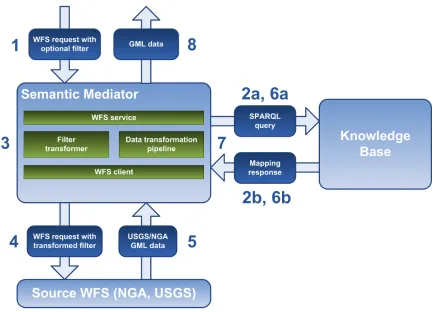
The Semantic Mediator is a web service capable of mediating between the NGA TDS and USGS TNM data models and providing access to the data through OGC web services. Using a common data model (RMM-S) as described in Chapter 8 and a knowledge base describing the mapping to this data model, the Semantic Mediator enables the
To allow existing NGA TDS or USGS TNM clients work transparently with both data sets, two OGC Web Feature Service (WFS) interfaces are defined:
An OGC WFS publishing the USGS TNM source data according to the NGA TDS data model;
An OGC WFS publishing the NGA TDS source data according to the USGS TNM data model.
Additionally, the Semantic Mediator offers an OGC Feature Portrayal Service (FPS), enabling clients to access the data as images. Users of the FPS can supply an OGC Styled Layer Descriptor (SLD) to select a WFS data source (NGA or USGS) and choose a rendering style. The FPS loads and renders the data accordingly, and returns the results as an image.
To better explain the mediation approach applied by the Semantic Mediator, Figure 7 illustrates the work flow between an incoming WFS request and an outgoing response with GML data. It should be noted that Figure 7 presents a subset of the CCI workflow. The complete CCI semantic mediation workflow is presented as use cases in Section 13.1.