Proceedings
Regional Geoheritage Conference 2016
The 9
ThIndonesia-Malaysia Conference
“Exotic Past for our Future”
Seminar Held on 24 November 2016
In Hotel Hyatt Regency Yogyakata, Indonesia
Proceedings
Regional Geoheritage Conference 2016
The 9
ThIndonesia-Malaysia Conference
Scientific editors
Sari Bahagiarti K Ibrahim Komoo Yunus Kusumahbrata
Suharsono Mohd. Syafeea Leman
Che Aziz Ali Hanang Samodra
C. Danisworo Bambang Prastistho
Suvapak Imsamut
Technical Editors
Muhammad Yusuf MuslimGneis Desika Zoenir
Chairman
Bambang Prastistho
FACULTY OF MINERAL TECHNOLOGY
UNIVERSITAS PEMBANGUNAN NASIONAL “VETERAN’
YOGYAKARTA
COMMITTEE OF REGIONAL GEOHERITAGE CONFERENCE 2016
Steering & Scientific Committee
Prof. Ir. Dr. Sari Bahagiarti K. – Rector of Universitas Pembangunan Nasional
“Veteran” Yogyakarta
Prof. Emeritus Ibrahim Komoo – Vice Precident of Global Geopark Network
Enviromental and Natural Resouces Cluster in Malaysia
Dr. Yunus Kusumahbrata – Expert Staff of Ministry Energy and Mineral Resources
Dr. Suharsono – Deen of Faculty of Technology Mineral
Prof. Dr. Mohd. Syafeea Leman Prof. Dr. Che Aziz Ali
Ir. Hanang Samodra, M.Sc. Prof. Dr. Ir. C. Danisworo, M.Sc. Prof. Dr. Ir.Bambang Prastistho, M.Sc. Dr. Suvapak Imsamut
Organizing Committee
Preface
Bismilahirrahmanirrahim, Assalamu’alaikum wa rahmatulahi wa barokatuh.
Dear distinguished participants and committee.
In this nice opportunity, I appreciate to all of you for your considerable effort that made the Regional Geoheritage Conference 2016 or the 9th Joint Conference
Indonesia – Malaysia Geoheritage Conference happened.
I really thankful to your participations for joining and attending the Conference in Yogyakarta. Special Region of Yogyakarta is well known as education and cultural city. Yogyakarta also become a considerable touristic region especially in cultural heritage. Right now geoheritage in Yogyakarta become more attractive.
In this occasion, the conference is very simple. Conference will be held over two days. First day we will held conference and geotrack in the second day.
There is two main speakers for RGC 2016. The first speaker is Mr. Ibrahim Komoo as Vice President Global Geoparks Network (GGN) and Mr. Yunus Kusumahbrata as Expert Staf Ministry of Energy and Mineral Resources of Indonesia Republic. For the next season, we also have speakers from Thailand and two speakers from Gunungsewu UGG and Batur UGG Indonesia. Moreover, we have 30 outstanding papers that will be presented in this conference. The papers are consist in 12 oral papers and 23 posters presentation with the same value.
In geotrack we will discover several geoheritage sites in Gunungsewu UGG, such as Miocene pillow lava of Berbah; ancient volcanic product of Nglanggeran; exciting bioturbation within shallow marine Sambipitu Formation; and Karst Museum of Indonesia at Wonogiri.
I wish this conference will give us inspirations and enhance the cooperation in Southeast Asia countries, especially in the field of geoheritage. Happy sharing for the progress of our region.
Finally, I would like to express my gratitude to Geological Agency – Ministry of Mineral Resources, especially Center of Geological Survey performa a booth concerning the wonderful of geoheritage and geopark of Indonesia.
Wassalamu’alaikum wa rahmatulahi wa barokatuh.
Table of Content
Committee Preface
Table of Content
(O1) Geoheritage of Bau: An Important Geo-Area in the Roposed Sarawak Delta
Geopark 1
(O2) Strike Slip Deformation of the Post Cretaceous Period at the Genting-Klang Quartz Ridge, Selangor, Peninsular Malaysia 2 (O3) Magnificence Geological Phenomenon Along sg. Batu Pahat: Inspiring the
Jerai Geopark Initiative 14
(O4) Paleoclimatic Change Analysis Based on Stratigraphic Data, Jayapura and its Surrounding Area, Jayapura District, Papua Province 16 (O5) Quantitative Assessment of Cave Stability Analysis at Gua Damai, Batu Caves,
Selangor 17
(O6) Kajian Potensi Geopark Gunung Penanggungan Kabupaten Mojokerto dan
Pasuruan, Provinsi Jawa Timur 27
(O7) Invontori Geotapak di Kedah Perancangan dan Pengurusan 34 (O8) Optimum Carrying Capacity Assessment Using Remote Sensing Approach in Candi Ijo Geoheritage of Yogyakarta 35
(O9) Geoheritage of Bukit Panau, Kelantan 36
(O10) Kembangsongo Fault Zone: an Exposed Segment of the Regional Opak Fault
Proposed as A New Geosite 37
(O11) Geosites in Gua Musang Area, Kelantan: Potential for National Geoparks 38 (O12) Pengenalpastian dan Pembangunan Geotapak di Dalam Cadangan Jerai
Geopark 39
(P1) Conserving Local Mining as Geoheritage in the Region for Geosciences 42 (P2) Kajian Potensi Geopark Kawasan Karst Biduk-biduk Kabupaten Berau,
Kalimantan Timur 50
(P4) Geotapak di Gua Musang, Kelantan: Potensi untuk Geopark Kebangsaan 58 (P5) The Traditional Petroleum Well in Wonocolo Area as A Beautiful Education
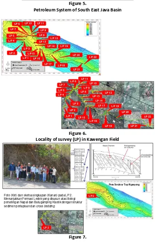
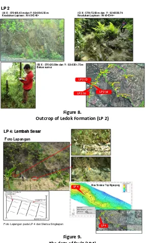
(P6) The Structure of Kawengan Anticline as A Lowest Petroleum System in
Indonesia 63
(P7) Development of Pundong Area as Geoheritage and Education Tourism
Pundong Parangtritis Yogyakarta 75
(P8) Characteristics of Karst and its Environment in Waigeo Island Raja Ampat
Archipelago 82
(P9) Pengelolaan Sumber Daya Geologi Secara Kerkelanjutan Di Pulau Lombok
NTB 83
(P10) The New Energy and Reneweble Energy in Ngentak-Kuwaru, Srandakan Regency of Bantul as Interesting Place of Tourism 99 (P11) The Proposed Kudat-Bengkoka Peninsula Geopark: A Potential Geopark at
Northern Sabah, Malaysia 100
(P12) Kajian Potensi Geowisata Gunung Lemongan, Kabupaten Lumajang, Jawa
Timur 101
(P13) Kajian Geologi Air Terjun Curug Cilontar Sebagai Objek Wisata Geologi di Desa Kracak, Leuwiliang, Bogor, Jawa Barat 102 (P15) Geodiversity of Landscape Papuma Beach, Jember, East java 103 (P16) Fossil Heritage of the Singa Formation, Langkawi Geopark, Malaysia 110 (P17) Geology and Geoheritage of Muara Wahau Coal Field, East Kalimantan,
Indonesia 111
(P18) Geoheritage Gunungapi Purba Batur, Yogyakarta : Sebuah Kajian Terintegrasi Untuk Konservasi Warisan Geologi dan Pengembangan Wisata Edukasi
Kebumian 120
(P19) Konservasi Geoheritage di Jawa Timur dan Analisa Area Kerentanan Tanah Berdasarkan Pengukuran Mikrotremor: Kompleks Kaldera Tengger 121 (P20) The Extreme Karst Class of Aspiring Geopark of Kinta Valley, Perak, West
Malaysia 129
(P21) Fractures Control of Groundwater Aquifer Configuration at Baturagung Volcanic Range, A Potential New Geosite of Gunung Sewu Geopark 130 (P22) People Perception on Berbah Pillow Lava Geoheritage 140
RGC, Yogyakarta, Indonesia, November 24-25, 2016 1 GEOHERITAGE OF BAU:
AN IMPORTANT GEO-AREA IN THE PROPOSED SARAWAK DELTA GEOPARK
Dana Badang Che Aziz Ali Ibrahim Komoo Mohd. Shafeea Leman
ABSTRACT
RGC, Yogyakarta, Indonesia, November 24-25, 2016 2 STRIKE SLIP DEFORMATION OF THE POST CRETACEOUS PERIOD
AT THE GENTING-KLANG QUARTZ RIDGE, SELANGOR, PENINSULAR MALAYSIA
Achmad Rodhi Mohd. Shafeea Leman
Lim Choun Sian
Department of Geology, University of Kebangsaan Malaysia (UKM), Bangi,Selangor
ABSTRACT
The residual of the natural rock erosion in the Gombak district of Selangor exhibit a ridge of quartz rock is incredible. In geology, preliminary studies indicate that the quartz dike has a close relationship with the local fracture pattern and major fault structure in the east-southeast trending which has been named as Kuala Lumpur fault by Stauffer (1968). The presence of so many small veins in quartz dikes, it shows that this quartz crystallize in the fracture system that has developed gradually in a relatively long period.This study used detailed research methodology with detailed data acquisition along the ridge, about 6 km. As expected found sufficient data for analysis Fault Zone, veins and faulted rock. In this detailed trajectory represented 18 blocks of detailed observations, detailed systematic observation focused on selected local area. Field observations show that not at all region have same quartz veins pattern in the ridge. In each block region observation, there are several combinations of quartz veins variation. Dispersion patterns of quartz vein in the ridge, always follow system of fractures and bounds on north and south side by ESE-WNW fracture system direction, and not found branches of veins. The 18 prominent strike modes of vein lineaments can be interpreted as being produced by two maximum horizontal stresses acting along 065o and 090o . It can be concluded that the
E-W and 070o-250o compressions responsible for the Late Triassic orogeny, were still active
during and after the emplacement of the granitoids. The 119 Ma Granites which are elongated parallel to the NW-SE regional structural trend, would best be regarded as post Jurassic Orogenic, and the 70 Ma Granites which trend NNW-SSE as post Cretaceous orogenic.
INTRODUCTION
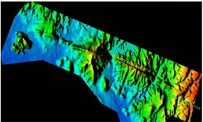
RGC, Yogyakarta, Indonesia, November 24-25, 2016 3
Figure 1.1 : DTM & DSM IFSAR Sattelite immagery showing the Quartz Vein Ridge has a relationship with the local pattern fracture and major fault structure in the
northwest-trend which has been named as Kuala Lumpur Fault by Stauffer
(1968)
Southeast and east-southeast striking faults are dominant and are frequently filled with vein quartz. The largest of these quartz dykes is the Klang Gates Ridge, which stands out from the adjacent land surface to a height of 350 m Kuala Lumpur Fault position as compared to several other fault systems in the vicinity of Kuala Lumpur and Peninsular Malaysia have been discussed by Shu (1969), while Gobbet & Tjia (1973) has correlate between Kuala Lumpur fault with Endau fault interpreted as faulting connection Kuala Lumpur fault. In 1997, for the first time Tjia used geographic names Permatang Kuarza Genting Klang (quartz ridge) characteristics to explain in his study of faulting connection Kuala Lumpur to Damansara area. Kuala Lumpur faulting cutting the granite body and all older rocks. The complex interlacing character of deformed and undeformed quartz vein with in the dyke, considered with remnants of partly to almost completely altered granite, reflects multiple intrusions. The presence of so many small veins in quartz dikes, it shows that this quartz crystallize in the fracture system that has developed gradually in a relatively long period
RGC, Yogyakarta, Indonesia, November 24-25, 2016 4 METHODOLOGY
This study used detailed research methodology with detailed data acquisition along the ridge, about 6 km. As expected found sufficient data for analysis Fault Zone, veins and faulted rock. In this detailed trajectory represented 18 blocks of detailed observations. Detailed systematic observation focused on selected local area. The petrological study was carried out under microscope to unravel the more detailed information on the identity of rocks based on Mineralogical composition, texture, structure and petrogenesis. Orientational structural data were analysed by means of manual hemisphere stereographic projection plot, Dips software Version 3.7 and Paleostress Version 3:11. That is accomplished by a computer software.
Crosscutting Relationship
Quartz veins are usually the latest of all the intrusions in the granite, and they cut both aplite and pegmatite dykes. They are characteristically approximately parallel alignment, indicating injection along joint directions in the outer portions of batholith It was formed by the deposition of hydrothermal quartz along a near-vertical zone of weakness in the granite (Alexander and Procter 1955). Therefore, the focus of this study is to characterize the deformation style for each major fracture sets in the Genting-Klang Quartz Ridge, identify the cross-cutting relationships and attempt to reconstruct their structural evolution in view of that of the Kuala Lumpur Fault Zone.
EVIDENCE FOR QUARTZ RIDGE DEFORMATION
The quartz ridge on the Kuala Lumpur fault zone at the Genting-Kelang ridge area show evidence for four successive vein episodes: The first generations (D1) generally, conjugate quartz veins N265oE – N275oE and N225oE – N230oE (Figure 2.2),
occurs most commonly in association with quartz vein N280oE-N285oE, those are major
veins and have spaced 30 to 300 m apart.
U
WNW
Figure 2.2 : (A) An idealised sketch to show the geometrical and genetical relationship between the large scale sinistral conjugate veins.
(B) The sinistral conjugate pattern outcrop can be observed on megascopic scales ranging from 33 m to more than 100 m, in Bukit Tabur Barat, near Kelang Dam (Block 3). Those trending are N265oE and N225oE, mostly associated with N285oE
ESE R
R1
RGC, Yogyakarta, Indonesia, November 24-25, 2016 5 The second generation (D2) minor to medium scale veins generally, incline to sub horizontal dipping quartz veins, with dip directions toward ENE, (Figure 2.3) most commonly in association with conjugate veins N070oE-N075oE and N240oE-N245oE,
NW
2
3
1 1
Figure 2.3 : (A) An idealised sketch to show the geometrical and genetical relationship between the shallow dipping veins and the dextral veins.
(B) The shallow dipping veins pattern outcrop can be observed on megascopic scales ranging from 1,20 m to 30 m in Gunung Tabur Barat, near Gombak (Block 10).
A B
The third generation (D3)are minor to medium veins show spacings in the order of a few centimeters to about 300 cm, mostly conjugate quartz veins trend N250oE-N255oE and
N215oE-N220oE (Figure 2.3) occur commonly in association with quartz vein N265o
E-N270oE,
ENE WSW
Figure 2.4 : (A) An idealised sketch to show the geometrical and genetical relationship between the medium scale sinistral conjugate veins.
(B) The sinistral conjugate veins pattern outcrop can be observed on megascopic scales ranging from 66 cm to more than 300 cm, in Bukit Tabur Barat, near Kelang Dam (Block 2. Those trending are N250oE and N215oe, most commonly association with N265oE
A B
Finally, the fourth generation (D4)are minor veins show spacings in the order of a few centimeters to about 300 cm, mostly conjugate quartz vein trend N060oE-N065oE and
N080oE-N085oE (Figure 2.3 ), occur commonly in association with quartz vein N045o
RGC, Yogyakarta, Indonesia, November 24-25, 2016 6
NE
Figure 2.5 : (A) An idealised sketch to show the geometrical and genetical relationship between the conjugate dextral veins.
(B) The dextral conjugate veins pattern outcrop can be observed on megascopic scales ranging from 0,60 cm to 3 m in Gunung Tabur Timur , near Kelang Dam (Block 12). Those are trending N060oE and N085oE, mostly associated with N045oE
A B
CHARACTERIZATION OF QUARTZ VEIN IN GENTING-KELANG RIDGE
The detailed structured of this ridge are character of deformed and undeformed quartz vein with in the ridge, considered with remnants of partly to almost completely altered granite, reflects multiple intrusions. In general major veins are spaced 30 to 300 cm apart, and minor veins show spacings in the order of a few centimeters to about 10 cm. At the whole Genting-Klang Ridge area, the major SE-NW veins (First Generation) were occured to be open fractures with very well comb structure.. In the eastern part of Bukit Tabur Barat area (Klang Gate – Top of Bukit Tabur Barat) or Block 1 to Block 7, enerally show minor to middle veins trends along N265oE-N275oE (Third Generation) whereas in
the western part of Bukit Tabur Barat (Top of Bukit Tabur Barat-Gombak) area or Block 8 to Block 10 generally show minor to middle veins trends along N040oE-N045oE (Fourth
Generation) and most commonly associated with thinning and thickening major quartz veins trends along N285oE – N290oE. In the western part of Bukit Tabur Timur (Klang
Gate to Top of Bukit Tabur Timur) generally show minor quartz veins trends along N040oE-N050oE (Forth Generation) and most commonly associated with subhorizontal
veins (Second Generation), whereas in the eastern part of Bukit Tabur Timur (Top of Bukit Tabur Timur to Kampung Tua) most commonly show intersection minor veins of the third generation and fourth generation.
The First Generation Of Quartz Veins (D1)
The first generation (D1) generally, major quartz vein and have thick variety from 15 to 30 cm, It is occurs most commonly in association with quartz gouge to mylonite cataclasite metamorphic, The D1 consists of three vein sets.
The first set of veins (N280oE – N285oE) is a directional veins aligned with the ridge and
RGC, Yogyakarta, Indonesia, November 24-25, 2016 7 that the second set of veins is the Riedel’s shear (R) or synthetic shear in simple shear system on a single fault. The third set of veins N225oE – N230oE that make a high angle
to the whole zone, it is identified that the third set of veins is Riedel’so Shear (Ro) or as
antithetic fractures in simple shear system on a single fault. Palaostress analysis showed that the first generation formed by sinistral strike slip fault WNW-ESE directional with the horizontal directional stresses ENE-WSW. (Figure 3.4).
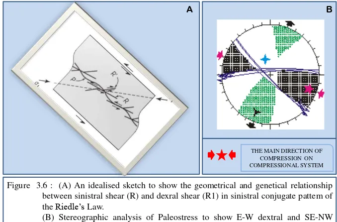
THE MAIN DIRECTION OF COMPRESSION ON COMPRESSIONAL SYSTEM
Figure 3.6 : (A) An idealised sketch to show the geometrical and genetical relationship between sinistral shear (R) and dexral shear (R1) in sinistral conjugate pattem of theRiedle’sLaw.
(B) Stereographic analysis of Paleostress to show E-W dextral and SE-NW Sinistral in the SSE-NNW sinistral conjugate pattern by compressional system with ESE- trending highest stress (The Main Direction )
A B
The Second Generation Of Quartz Vein (D2)
The Second generation (D2) generally minor to medium scale veins, incline to sub horizontal dipping quartz veins, with dip directions toward ENE, (Plate 2.3).The second generation consists of two set of veins. The first set of veins are trending to N350o
E-N355oE, generally incline to sub horizontal dip quartz veins, with dip directions toward
ENE, perpendicular with horizontal stresses of D1, it is estimate that the first vein sets of the second generation is reverse shear fracture (RF) in simple shear system on a single fault with the horizontal directional stresses ENE-WSW. The second set of veins was conjugate N070oE-N075oE and N240oE-N245oE, relatively parallel with resultante
direction, it is estimate that the second vein sets is the tention fracture or T fracture (TF)
RGC, Yogyakarta, Indonesia, November 24-25, 2016 8
A B
Figure 3.7 : (A) An idealised sketch to show the geometrical and genetical relationship the reverse shear fracture or reverse fault in ESE-WNW sinistral conjugate pattem of theRiedle’sLaw.
(B) An idealised Riedle’s Law model to show the geometrical and genetical
relationship between reverse shear fault (RF) and normal fault (TF) in dextral conjugate pattern
THE MAIN DIRECTION OF COMPRESSION
ON COMPRESSIONAL SYSTEM
The Third Generation Of Quartz Veins (D3)
The thirdt generation generally, minor to medium quartz vein and have spaced 5 to 20 cm apart, and thick variety from 1 to 10 cm, It is occurs most commonly in association with quartz cataclasite brecciation to mylonite cataclasite metamorphic. The third generation consists of three sets of veins. The first set of veins N265oE-N270oE is a
directional vein aligned with the block of local region and same with the second vein of the first generation. It is estimated that the first set of the third generation is the secondary Primary Shear (P1 shear) in simple shear system on a single fault. The second set of the
third generation veins N250oE-N255oE makes a low angle with P1 shear and block of
local region shear zones. It is estimate that the second set of veins is the secondary
Riedel’s shear (R1) or as synthetic shear in simple shear system on a single fault. The
third set of the third generation veins N215oE-N220oE that make a high angle to the block
of local region shear zone, it is identified that the third set of veins is the secondary
Riedel’so Shear (Ro1) or as secondary antithetic shear in simle shear system on a single
RGC, Yogyakarta, Indonesia, November 24-25, 2016 9
Figure 3.8 : (A) An idealised sketch to show the geometrical and genetical relationship between sinistral shear (R) and dexral shear (R1) in sinistral conjugate pattem of theRiedle’sLaw.
(B) Stereographic analysis of Paleostress to show E-W sinistral and NE-SW dextral in the ENE-WSW sinistral conjugate pattern by compressional system with ENE- trending highest stress (The Main Direction )
THE MAIN DIRECTION OF
COMPRESSION ON
COMPRESSIONAL SYSTEM
The Fourth Generation of Quartz Veins (D4)
The fourth generation generally minor to medium quartz veins, show spacings in the order of a few centimeters to about 10 cm, and thick from 3 to 5 cm. It is occurs most commonly in association with quartz cataclasite metamorphic, quartz cataclasite brecciation with xenoblast granite. The fourth generation consists of three sets of vein. The first set of veins N040oE-N050oE is a directional fracture aligned with the block of local region and
same with the third set of veins of the first generation. It is estimated that the first set of the third generation is the secondary Primary Shear (P1 shear) in simple shear system
on a single fault. The second set of the fourth generation veins N060oE-N065oE makes a
low angle with P1 shear and block of local region shear zones. It is estimate that the second
set of veins is the secondary Riedel’s shear (R1) or synthetic shear in simple shear system
on a single fault. The third set of the second generation veins N080oE-N085oE that make
a high angle to the block of local region shear zone, it is identified that the third set of veins is the secondary Riedel’so Shear (Ro1) or as secondary antithetic shear. Palaostress
RGC, Yogyakarta, Indonesia, November 24-25, 2016 10 A
B
Figure 3.9 : (A) An idealised models to show the geometrical and genetical relationship between sinistral shear (R) and dexral shear (R1) in dextral conjugate pattem of theRiedle’sLaw.
(B) Stereographic analysis of Paleostress to show NE-SW dextral and SE-NW Sinistral in the NE-SW dextral conjugate pattern by compressional system with E-W trending highest stress (The Main Direction )
DISCUSSION
Block to block region analysis show that the first generation (D1) is oldest veins, They are vertical conjugate veins, characteristically approximately parallel toward ESE-WNW alignment or fault zone, indicating injection along joint directions in the a Single Sinistral Strike Slip Fault Zone with horizontal stress direction to ESE-WNW and we believed that is Kuala Lumpur Fault Zone. D2 stage, illustrated by reverse fault and sheared zone is also showing ESE-WNW compression and may be the continuation of the D1. This deformation is mostly expressed on top of the block, subsequently D1 vein sets. D2 stage also show conjugate tension fracture (T fracture), its suggest that the fault movement is not continued to the D3 deformation. The type of D1-D2 deformation is defferent with the collisional orogeny. According to Hutchison (2007) almost immediately after this collisional orogeny, pre-rift structures formed in many localities away from the collision zone, and major strike-slip faulting cut obliquely across the collision fold belt in a predominantly north-northwest- south-southeast direction and also possibly sub-parallel to the suture zone. Impressive post-collision S-type tin granites have been dated predominantly at 220-199 Ma (Bignell & Snelling,1970; Liew and Page, 1985; Kwan, 1989; Krahenbuhl, 1991 or Late Triassic age). The sinistral transpressive deformation of D1-D2 produced zones of high flattening strain and WNW-striking sinistral brittle shear zones. These WNW trending shear zones controlled the physiographic development of this area in such a way that the WNW-NW quartz ridge tends to be parallel to the shear zones. This trend can be traced right to the Kuala Lumpur-Endau Fault zone. The D1-D2 sinistral transpressive deformation could possible be a post Late Triassic age. However, from regional correlation, it can be speculated that the D1-D2 structures would have been resulted from strong sinistral transpressional deformation by the West Borneo Basement rifting from Indosinia.
RGC, Yogyakarta, Indonesia, November 24-25, 2016 11 movement continued or reactivated during that time. However, from regional correlation, it can be speculated that the D3-D4 structures would have been resulted from strong the collision a conjugated fault system by the collision of the Burma Arc to the East Asian Continent in Cretaceous time (Hutchison, 1988). The timing of D3 and D4 deformation based on magmatism and volcanism in the range 140-120 Ma magmatism and volcanism in the range 140-120 Ma. (Krahenbuhl, 1991; Khoo, 1993). The late-Cretaceous magmatism (90-80 Ma) of Peninsular Malaysia is contemporaneous with the major differential uplift phase infered from isotopic and petrographic evidences, as in the Main Range east of the Bukit Tinggi fault in the Kuala Lumpur area (Krahenbuhl, 1991).
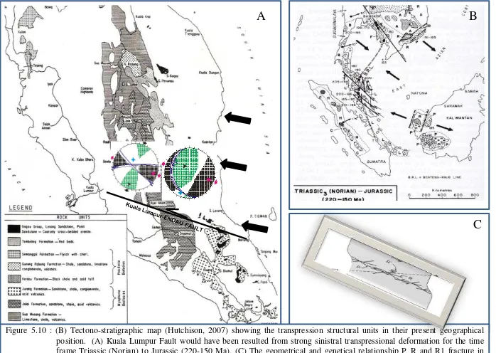
MODEL AND CONCLUSION
Transpression Model Triassic to Jurassic prime time.
Kuala Lumpur-Endau Fault Zone indicates that the D1-D2 deformation was the result of an SE-NW sinistral transpressive resulting from oblique compressional stresses by the West Borneo Basement rifting from Indosinia.
Figure 5.10 : (B) Tectono-stratigraphic map (Hutchison, 2007) showing the transpression structural units in their present geographical position. (A) Kuala Lumpur Fault would have been resulted from strong sinistral transpressional deformation for the time frame Triassic (Norian) to Jurassic (220-150 Ma). (C) The geometrical and genetical relationship P, R and R1 fracture in sinistral conjugate forRiedle’sLaw
A B
C
Reactivated.Model Cretaceous prime time.
The conjugate NE-SW dextral faults and ENE-WSW sinistral faults have significant component of strike-parallel with R and R1 fracture on sinistral fault zone pattern. It can
RGC, Yogyakarta, Indonesia, November 24-25, 2016 12 Figure 5.11 : (B) Tectonic Evolution map for the time frame Late Jurassic to Cretaceous (Robert Hall & D.J. Blundell, 1996) showing
doubly subduction in SE Asia with ENE-WSW trending compressional subduction deformation. (B) Kuala Lumpur Fault would have been reactivated from WNW-trending to WSW and SW-trending. (C) The geometrical and genetical relationship between P, R and R1 fracture in transpressional deformationRiedle’sLaw.
A B
C
Modification from Khoo, 1993
CONCLUSION
Along the western foothills of the Main Range, the Lower Palaeozoic schist is intruded by a sub-vertical quartz dyke (Klang Gates Quartz Ridge) along the N300oE to N320oE
-trending Kuala Lumpur Fault Zone. The strike slip structures indicated a different type with the Triassic-collisional orogeny, it can be interpreted that the structures would have been resulted from strong sinistral transpressional as soon as a after the emplacement of the Upper Triassic granites.
The Cretaceous age suggest that the fault movement continued at least until Middle Cretaceous or it was reactivated during that time with the ENE-WSW reorientation trending. Finally, the late-Cretaceous magmatism had been injected through a small and local area into Kuala Lumpur Fault Zone.
ACKNOWLEDGEMENTS
We extend my thanks to management of Jabatan Mineral dan Geosains Selangor
especially Dato’ Haji Zakaria bin Mohamed and En. Qalam A’zad bin Rosle for sponsored to undertake research on their property.
REFFERENCES
Adam, W. 1953. The Klang Gate Ridge. Malayan Nature Journal. 8: 89-93.
Alsop, G.I., Holdsworth, R.E., Mc Caffrey, K.J.W., and Hand, M., 2004. Flow Processes in Faults and Shear Zone, Geological Society special publication 224, London. p 375.
Ben, A. van der P and Marshak. 2004. Earth Structure. An Introduction Structural Geology and Tectonic, 2nd Edition, w.w. Norton & Company, New York –
London, 596p
RGC, Yogyakarta, Indonesia, November 24-25, 2016 13 Bignell, J.D. and Snelling, N.J. 1977. Geochronologi of Malayan Granite: Overseas Geology and Mineral Resources. 47:70 hlm. London : Institute of Geological Science
Burton, C.K. 1965. Wrench Faulting in Malaya. Journal of Geology 73: 781-798. Burton, C.K. 1973. Mesozoic. In: Gobbett, D.J. & Hutchison, C.S. (eds). Geology of the
Malay Peninsula, New York, Wiley-Interscience: 97-144.
Fossen Haakon, 2010. Structural Geology, Cambridge University Press, New York, 1 st edition, p. 463.
Geological Survey of Malaysia 1985. Geological Map of Peninsular Malaysia 8th edition.
Gobbett, D.J. & Hutchison, C.S. (eds.) 1973. Geology of The Malay Peninsula (West Malaysia and Singapore). Wiley-Interscience, New York
Hutchison, C.S. 1973. Plutonic Activity. vide Gobbett, D.J. & Hutchison, C.S. (editor) Geology of the Malay Peninsula. Wiley-Intersciense, New York. 215-252. Hutchison, C.S. 2007. Geological Evolution of South-East Asia. Geological Society of
Malaysia, Kuala Lumpur. 2nd edition. 433p.
Khoo, H.P. 1983. Mesozoic stratigrapgy of Peninsular Malaysia. Proceeding of the Workshop on stratigraphic Correlation of Thailand and Malaysia: 307-383. Kwan, T.S. 1991. K-Ar dating of mica from granitoids in the Kuala Lumpur-Seremban
area, vide Krahenbuhl. 1991. Magmatism, tin mineralization and tectonics of the Main Range, Malaysian Peninsula: Consequences for the plate tectonic model of Southeast Asia based on Rb-Sr, K-Ar and fission track data. Bulletin of the Geological Society of Malaysia. 1-100
Krahenbuhl. 1991. Magmatism, tin mineralization and tectonics of the Main Range, Malaysian Peninsula: Consequences for the plate tectonic model of Southeast Asia based on Rb-Sr, K-Ar and fission track data. Bulletin of the Geological Society of Malaysia. 1-100
Mark, R.H. Hirth, G. and Hovius, N. 2007. Tectonic Fault, Agents of Change on Dynamic Earth, Dahlem Workshop Report, 95th, The Dynamic of Fault Zone, Berlin, 429p
Mustaffa Kamal Shuib. 2009. Major Faults, vide Hutchison, C.S. & Tan, D.N.K. (editor) Geology of Peninsular Malaysia. Publisher University of Malaysia, 249-269. Nemcok, M. Schamel, S. and Gayer, R. 2009. Thrust belts. Structural Application,
Thermal regim and Petroleoum System, Cambridge University Press, New York, 537p
Shu, Y.K. 1969. Some NW trending faults in the Kuala Lumpur and other areas. Newsletter Geological Society of Malaysia 17, 1-5.
Stauffer, P.H. 1968. The Kuala Lumpur fault zone. Newsletter Geological Society of Malaysia 15, 2-4.
Tjia H.D. 1997. The Kuala Lumpur fault zone revisited. Warta Geologi 23(4), 225-230. Yin, E.H. 1974. Geological map of Kuala Lumpur, sheet 94, scale 1:63360. Geological
RGC, Yogyakarta, Indonesia, November 24-25, 2016 14 MAGNIFICENCE GEOLOGICAL PHENOMENON ALONG SG. BATU
PAHAT: INSPIRING THE JERAI GEOPARK INITIATIVE
Askury Abd Kadir
Geology of southern part of G. Jerai complex along the Sg Batu Pahat display a marvelous geological features. The origin of the G. Jerai deduced from the crustal thickening after the collision of Sibumasu with Indochina plate during Mid–Triassic, where the thick sequence of Cambrian clastic sedimentary rocks uplifted by granite intrusion. There are two distinctive lithologies present in G. Jerai, which are metasedimentary rock of Jerai Formation and granite. Sg. Batu Pahat is synonym to Candi Bukit Batu Pahat is the most well-known ancient Hindu temple found in Bujang Valley. These archaeological artifacts reveal that there was a Hindu-Buddhist polity here more than 2535 years old. Lithologically, it is mainly composed of fine-grained leucogranite which was cut by series of pegmatite dykes at different episodes. The magnetic differentiation process is the most prominent, where the highly evolved leucogranite intruded at an exceptional high level. It contains high felsic with two mica minerals. The spectacular pegmatite dykes intruded into granite striking to 030o and 340o with the thickness ranges from 0.8 to 4.5m.
Extra-large muscovite flakes are the most magnificence mineral in pegmatite together with euhedral six-sided crystals of tourmaline. Garnet (grossularite) are also present as an accessory mineral. There are less fractures identified from the entire outcrop, which is generally massive and solid. However, one of the pegmatite dyke striking to 030o has
RGC, Yogyakarta, Indonesia, November 24-25, 2016 15 Fig 1: Location map of G. Jerai, Kedah, Malaysia. Fig 2: The Magmatic differentiation conceptual
model
Fig 3: Pegmatite formation conceptual model. (A) Before erosion; (B) After erosion
RGC, Yogyakarta, Indonesia, November 24-25, 2016 16 PALEOCLIMATIC CHANGE ANALYSIS BASED ON STRATIGRAPHIC DATA,
JAYAPURA AND ITS SURROUNDING AREA, JAYAPURA DISTRICT, PAPUA PROVINCE
C. Danisworo1
Achmad Subandrio1
Theodora Ngaderman2
Angelina Majesty Randa3
1 Geological Engineering Department, FTM, UPN “Veteran” Yogyakarta
2 Geological Engineering Department, USTJ, Jayapura, Papua 3 Geological Engineering Department, UNIPA, Sorong, West Papua
ABSTRACT
Paleoclimatic changes occuring in Papua are very important to be recognized, particularly in relation to the existence of permafrost snow covering The Jayawijaya Mountain. The study, which is focussed on Jayapura Formation, was carried out by applying a mapping method, detailed measuring sections, and petrography and micropaleontological analyses. Jayapura area has a variety and very complex rocks, one of them is a sedimentary rock having carbonate chemical composition, so called Jayapura Formation, which covers large enough of the studied area. A limestone sample of Jayapura Formation taken from the Base G area indicates the existence of a planktonic foraminifera fossils. By using these fossils content, the age of Pleistocene Epochs can be decided. The limestone of Jayapura Formation was deposited in bathyal to abysal zones, an open sea, where there was no more detrital (clastical) material from a continent, and showing that from the Late Miocene to Pleistocene the environment of studied area changed from lithoral to bathyal environments due to the sea level raising. Generally, this limestone uncoformably overlies the serpetinite lithodem of metamorphic unit which is part of the Cycloop Metamorphic Group. Taking a consideration of the right turning fossil, the climate during the formation of limestone can be interpreted as a warm and wet climate. Furthermore, a few fossils found in the middle part the limestone of Jayapura Formation shows a opposite turning. Therefore it is interpreted that during the Late Pliocene or Early Pleistocene Epochs the limestone was sedimented in the cold and dry climate. From the lithological development, the limestone generally consits of a calselutite intercalated by a marl in the middle part. In the Mawesday area, Sarmi District, that is the western part of the studied area, a paleoclimatic change during Plio-Pleistocene Epochs can
be recognized. The appearance of nannoplankton, Discoaster brouweri characterzises the end of
a cold climate. The Aurumi Formation containing claystone with coal intercalations demonstrates a dry cold climate. Further study concerning a paleoclimatic change, specially in Papua, it is very importance to be carried out, regarding Papua is one of two places along the equator where the snow still exist covering the mountaineous area. Hopefully, the paleoclimatic changes especially during Pleistocene Epoch, Quaternary Peiode, can be used to provocate or campaign in order to protect or preserve the existence of snow covering Jayawijaya Maountain, in Papua.
RGC, Yogyakarta, Indonesia, November 24-25, 2016 17 QUANTITATIVE ASSESSMENT OF CAVE STABILITY ANALYSIS AT GUA
DAMAI, BATU CAVES, SELANGOR
1 School of Environmental and Natural Resource Sciences, Faculty of Science and
Technology, Universiti Kebangsaan Malaysia, 43600 UKM Bangi, Selangor Darul Ehsan, Malaysia
2 Department of Geosciences, Universiti Teknologi PETRONAS, Bandar Seri
Iskandar, 31750 Tronoh, Perak Darul Ridzuan, Malaysia
3 Chemical and Petroleum Engineering Department, Faculty of Engineering,
Technology and Built Environment, UCSI University, 56000 Cheras, Malaysia *Corresponding author: [email protected] or [email protected]
ABSTRACT
The limestone hill of Batu Caves is now becoming a recreation park for slope climbing, base jumping and cave exploring. Assessment on cave stability is essential to ensure the public safety. This study aims to assess the cave stability for Gua Damai, Batu Caves, Selangor by using relationship of system Q classification system with cave width and ratio of cave roof thickness with cave width quantitatively. Stability of cave wall is identified too using slope mass rating (SMR). The lithology of the study area is limestone with low grade metamorphism and white in colour. Discontinuity survey on the slope under the cave shows that the rock mass is influenced by four main joint sets which are J1, J2, J3, J4 with the dip direction and angle of 110˚/73˚, 325˚/87˚, 243˚/39˚ and 054˚/30˚.
According to kinematic analysis, the dip direction/dip angle of wedge failure is 051˚/59˚.
Ratio of cave roof thickness and cave width shows that the cave is stable and the stability increasing from center to the wall. The relationship between Q system and the cave width shows that the cave at sections 4 and 8 are stable while the cave in sections 1, 2, 3, 5, 6 and 7 require support. Based on SMR, the cave walls stability for slope of c, d, and f are not stable while the slope walls of a, b, e and g are stable. Overall, the most stable parts of the cave are section 4 and section 8 followed by section 1 and section 5. Section 6 is moderate and sections 2, 3 and 7 have poor stability.
Key words: limestone, cave stability assessment, Gua Damai
INTRODUCTION
RGC, Yogyakarta, Indonesia, November 24-25, 2016 18 The local researcher such as Goh et al. (2015a, 2015b, 2016a, 2016b), Norbert et al. (2015), Tan (2001) and Tan (2006) were more focused on limestone slope stability and rock material strengths. Less research and study had been reported in limestone cave stability in Malaysia. Therefore, this aims of this study was to assess the cave wall stability using slope mass rating (SMR) and cave stability by using rock mass classification of system Q, cave width and thickness of cave roof for Gua Damai, Batu Caves, Selangor quantitatively.
MATERIALS AND METHODOLOGY
Geological Setting
Batu Caves, Selangor is located at 13 km north of Kuala Lumpur (Figure 1). Gobbett & Hutchison (1973) reported that the limestone were crystalline, greyish to milky white, thick bedded, stripped marble, saccharoidal dolomite and pure calcatic limestone. Gua Damai is part of the Palaeozoic Formations of Selangor and Kuala Lumpur. The geology of the area consists of sedimentary rocks ranging in age from Middle-Upper Silurian to Mesozoic or Younger overlying the older Hawthornden Formation and the Kuala Lumpur Limestone Formation (Gobbett 1965).
Figure 1: The location of study area in Peninsular Malaysia, Malaysia Cave Wall Stability - Slope Mass Rating (SMR) Method
The slope mass rating method was proposed by Romana (1995) and used to assess the stability of rock slope. This method comprised of the following components:
(a) Uniaxial compressive strength (UCS) (b) Rock quality designation (RQD) (c) Discontinuities spacing
(d) Conditions of discontinuities (e) Ground water condition
RGC, Yogyakarta, Indonesia, November 24-25, 2016 19 The uniaxial compressive strength (UCS) of rock material was determined based on the recommendations of the International Society for Rock Mechanics (1981, 1985). The value of respective components of (b), (c), (d) and (d) were determined from scanline discontinuites survey, following suggestion of Ibrahim Komoo dan Ibrahim Abdullah (1983). F1 was the rating of in considering the difference of dip direction between joints and slope face. F2 was the rating of dip angle of the respective joint. F3 was the rating of considering the difference of dip angle between joints and slope face. The values of respective component of (a), (b), (c), (d) and (e) will be rated based on Romana (1995) suggestion. The total rating, RMRb was (Bieniawski 1989) determined as:
RMRb = Rating (a) + Rating (b) + Rating (c) + Rating (d) + Rating (e)
(1)
The rating for SMR was determined based on following equation suggested by Romana (1995) :
SMR = RMRb + (F1 x F2 x F3) +F4
(2)
Cave Stability Assessment
The value of system Q is calculated from Rock Mass Rating (RMR), suggested by Barton (1995) using the formula below:
RMR = 15 log Q + 50 (3)
The stability of limestone cave was classified based on recommendation of Waltham (2002) and Waltham and Fookes (2003). The value of system Q and width of limestone cave width was used to assess the stability (Figure 2). Waltham (2002) and Waltham and Fookes (2003) also suggested that the cave is stable when the thickness of the roof of the cave are more than 70% of the width of the cave.
RGC, Yogyakarta, Indonesia, November 24-25, 2016 20 RESULT AND DISCUSSION
A total of 200 of discontinuities survey was conducted on is the slopes beneath the cave (Figure 3). The cave was divided into 8 sections (1, 2, 3, 4, 5, 6, 7 and 8) (Figure 4). The cave wall was divided into seven portions which were (a), (b), (c), (d), (e), (f), and (g) according to the orientation of the wall (Figure 4).
Figure 3: The location discontinuities survey and cave at Gua Damai, Batu Caves, Selangor.
Figure 4: The cave walls and cave cavity were divided into 7 and 8 sections respectively according to the orientation on the cave walls.
Discontinuity survey show that the slope composed of four (4) major joint sets which are
J1, J2, J3, J4 with the dip direction and angle of 110˚/73˚, 325˚/87˚, 243˚/39˚ and 054˚/30˚
(Figure 5). The orientations of major joint sets are exhibited in Table 1.
RGC, Yogyakarta, Indonesia, November 24-25, 2016 21 Rock Mechanics (1981). The Rock Quality Designation (RQD) value for the limestone slope is 84.8%.
Table 1: Major Joint sets characteristic at Gua Damai, Batu Caves, Selangor, Malaysia
Joint
Aperture Roughness Water Condition
J1 110/73 0.98 1.79 very
Figure 5: Four major joint sets are labeled J1, J2, J3, J4 with the dip direction and angle
of 110˚/73˚, 325˚/87˚, 243˚/39˚ and 054˚/30˚.
Table 2 exhibits the summary rating for System Q for respective section 1, 2, 3, 4, 5, 6, 7 and 8 of Gua Damai, Batu Caves, Selangor, Malayasia. The rating for RMRb was 66. The
classification of Rock Mass Rating (RMR) suggested by Bieniawski (1989) for this limestone cave were from fair to good rock mass with the rating of 56 to 66.
RGC, Yogyakarta, Indonesia, November 24-25, 2016 22 Table 2: System Q value and classification system calculated from RMR value based on
joint orientations. The rating for RMRb was 66. Secti diagram shows that sections 4 and 8 are stable while sections 1, 2, 3, 5, 6, and 7 require support.
Source : Modified from Waltham (2002) and Waltham and Fookes (2003)
RGC, Yogyakarta, Indonesia, November 24-25, 2016 23 The results of assessment on the walls of cave based on Slope Mass Rating, SMR (Romana 1985) is exhibited in Table 3. The stability of cave walls for portion (c), (d), and (f) were not stable while the walls of (a), (b), (e) and (g) are stable. The portions of wall were not stable because the orientation of respective slope face of the cave wall was parallel to the wedge failure (051/59). Therefore, the walls rock in portion (c), (d), and (f) were potentially to have wedge failure with the probability of failure of 0.6.
Figure 7: The presence of limestone pillars in the middle of cave act as support to prevent collapse of cave roof.
RGC, Yogyakarta, Indonesia, November 24-25, 2016 24 Figure 9: The plan view and cross section of the cave at A-A’, B-B’, C-C’, D-D’ and E
-E’ shows that the cave cavity is higher in the middle causing thinner cave roof and lower stability.
Table 3: Stability of cave walls based on SMR classification system, Romana (1985).
Portion of cave wall/ Orientation (˚)
F1 F2 F3 F4 Failure
mode
SMR Stability Probability of failure
a
138/81
- - - - none 66 stable 0.2
b
100/68
- - - - none 66 stable 0.2
c
55/71
1.00 1.00 -60 +15 wedge
(51˚/59˚) 21 unstable 0.6
d
14/83
0.85 1.00 -60 +15 wedge
(51˚/59˚) 30 unstable 0.6
e
300/77
- - - - none 66 stable 0.2
336/83 1.00 1.00 -60 +15 wedge
(51˚/59˚) 21 unstable 0.6
RGC, Yogyakarta, Indonesia, November 24-25, 2016 25 CONCLUSION
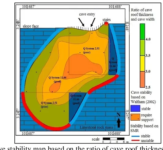
Figure 10 shows the final stability of cave for Gua Damai, Batu Caves, Selangor, Malaysia.
Based on the Q system and the cave width, the stabilities of sections 4 and section 8 of Cave Damai were stable while sections 1, 2, 3, 5, 6 and 7 require supports. Based on SMR, the cave walls stability at the portion of (c), (d) and (f) were not stable while portion (a), (b), (e) and (g) were stable. Overall, the most stable parts of the cave are section 4 and section 8 followed by section 1 and section 5. Section 6 is moderate and sections 2, 3 and 7 have poor stability.
Figure 10: Cave stability map based on the ratio of cave roof thickness with cave width, Q system with cave width and stability of cave wall based on SMR assessment.
ACKNOWLEDGEMENT
The authors wish to thank the lab staff of the Geology Programme and the Government of Malaysia for the financial assistance through grant 06-01-02-SF1140 and FRGS/1/2014/STWN06/ukm/02/1 and Universiti Kebangsaan Malaysia internal grant GUP-2014-30.
REFERENCES
Barton, N. 1995. The influence of joint properties in modelling jointed rock masses. 8th ISRM Congress 3(3):1023-1032.
Bieniawski, Z. T. (1989). Engineering rock mass classifications: a complete manual for engineers and geologists in mining, civil, and petroleum engineering. New York: John Wiley & Sons Inc.
RGC, Yogyakarta, Indonesia, November 24-25, 2016 26 Gobbett, D.J. & Hutchison, C.S. 1973. Geology of the Malay Peninsula, New York:
Wiley Interscience.
Goh, T.L., Abdul Ghani, R., Ailie, S.S., Norbert, S., Lee K.E., and Azimah, H. 2015a.Empirical Correlation of Uniaxial Compressive Strength and Primary Wave Velocity of Malaysian Schists. Electronic Journal Geotechnical Engineering 20: 1801-1812.
Goh, T.L., Abdul Ghani, R., Ailie, S.S., Norbert, S., Azimah, H. and Lee K.E. 2015b.Correlation of Ultrasonic Velocity slowness with Uniaxial Compressive Strength of Schists in Malaysian. Electronic Journal Geotechnical Engineering 20: 12663-12670.
Goh, T.L., Abdul Ghani, R., Ailie, S.S., Azimah, H. and Lee K.E. 2016a.Use of Ultrasonic Velocity Travel Time to Estimate Uniaxial Compressive Strength of Granite and Schist in Malaysia.SainsMalaysiana 45(2):185-193.
Goh, T. L., Ainul, M. M. R., Nur Amalina, M., Abdul, G. R., Nur Ailie, S. S. & Tuan, R. M. 2016b. Rock Slope Stability Assessment Using Slope Mass Rating (SMR) Method: Gunung Lang Ipoh Malaysia. Scholars Journal of Engineering and Technology (SJET) 4(4): 185-192.
Hatzor, Y. H., Talesnick, M. & Tsesarsky, M. 2002.Continuum and Discontinuum Stability Analysis of the Bell Shaped Caverns at Bet Guvrin, Israel. International Journal of Rock Mechanics & Mining Sciences 39(7): 867–886.
Ibrahim Komoo & Ibrahim Abdullah. 1983. Ketakselanjaran dan kaedah pengukuran di lapangan. Sains Malaysiana 12(2): 119-140.
International Society for Rock Mechanics. 1981. Rock characterization, testing and monitoring. In Brown, E.T. (Editor), ISRM suggested Methods. Pergamon Press,Oxfored, U.K..
International Society for Rock Mechanics. 1985, Suggested Method for Determining Point Load Strength, International Journal Rock Mechanics Mining Sciences and Geomechanics Abstracts, 22 (2):51-60.
Norbert, S., Muhammad Fahmi, A. G., Azimah, H., Goh, T. L., Abdul, G. R., Noraini, S., Tuan, R. T. M. & Lee, K. E. 2015. Assesssment of Rockfall Potential of Limestone Hills in the Kinta Valley. Journal of Sustainability Science and Management 10(2): 24-34.
Romana M. 1985. New adjustment ratings for application of Bieniawski classification to slopes. Int. Symp. on the Role of Rock Mechanics ISRM: 49-53.
Tan, B. K. 2001. Engineering Geology of Limestone in Malaysia. Journal of the Geological Society of China 75(3): 316 – 324.
Tan, B. K. 2006. Urban geology of Kuala Lumpur and Ipoh, Malaysia. IAEG 24.
Waltham, T. 2002. The engineering classification of karst with respect to the role and influence of caves. Int. J. Speleol 31(1/4): 19-35.
RGC, Yogyakarta, Indonesia, November 24-25, 2016 27 KAJIAN POTENSI GEOPARK G. PENANGGUNGAN
KABUPATEN MOJOKERTO DAN PASURUAN, PROVINSI JAWA TIMUR
Eko Teguh Paripurno1
Purbudi Wahyuni2
Helmi Murwanto1
1Teknik Geologi UPN “Veteran” Yogykarta, 2dan Ekonomi Manajemen UPN “Veteran” Yogyakarta
ABSTRACT
Penanggungan Volcano (7.615°N, 112.62°E), located at Mojokerto and Pasuruan districts, East Java Province. G. Penanggungan expressed as Penanggungan Volcanics and pyroclastics Unit Guarantee, in Upper Quaternary age. More detailed studies indicate that consists of diverse volcanic lithology, as lavas, pyroclastic flows and lahars, which confirmed his status as gunugapi Strato. In Penanggungan there are about 120 sites
Key words : Volcanostratigraphy, Geopark, G. Penanggungan
PENDAHULUAN
G. Penanggungan memiliki 6 kerucut parasiter yang tersebar di sekitarnya. G. Bekel di sebelah barat laut, G. Genting di sebelah utara, G. Kemuncup di sebelah timur, G. Bendo di sebelah selatan, G. Wangi di sebelah tenggara, dan G. Gajahmungkur di timur timur laut. Kehadiran beberapa pusat erupsi ini menunjukan adanya keanekaragaman litologi penyusun dari G. Penang-gungan. Dalam Peta Geologi lembar Malang (S. Santosa dan T. Suwarni, 2011) selama ini G. Penanggungan dinyatakan sebagai Satuan Piro-klastika Penanggungan berumur Kuarter Atas.
Lokasi ini diusilkan karena geopark bukan hanya tentang geologi, seperti dikemukaan pada pengertian geopark versi UNESCO sebagai berikut “A UNESCO Global Geopark must demonstrate geological heritage of international significance, the purpose of a UNESCO Global Geopark is to explore, develop and celebrate the links between that geological heritage and all other aspects of the area's natural, cultural and intangible heritages.”
RGC, Yogyakarta, Indonesia, November 24-25, 2016 28 METODE
Metode yang digunakan dalam penelitian penentuan stratigrafi G. Penanggungan dan hubunganya dengan keberadaan dan posisi situs-situs arkeologi ini adalah sebagai berikut :
1. Pengumpulan data sekunder, digunakan untuk mengetahui dan mempelajari hasil dari peneliti terdahulu yang bertujuan untuk mendapatkan gambaran hubungan dari litologi dan aktivitas vulkanisme di daerah penelitian terhadap posisi dan kondisi situs-situs. 2. Pengumpulan data lapangan, digunakan untuk data litologi, mata air, morfologi dan data profil stratigrafi, serta hubunganya dengan posisi dan kondisi situs-situs. Perlatan yang digunakan dalam metode penelitian lapangan ini antara lain Global Positioning System (GPS), kompas geologi, palu geologi, dan meteran.
3. Pekerjaan laboratorium dan analisis data, dilakukan hampir secara bersamaan yaitu mengenai analisa sayatan tipis petrografi.
GEOMORFOLOGI
Morfologi gunungapi merupakan bentukan morfologi permukaan bumi yang spesifik akibat dari hasil dari interaksi antara proses eksogen dan endogen. Morfologi gunungapi tidak hanya dipengaruhi oleh material-material hasil erupsi dan tipe erupsinya saja, tetapi juga dikontrol oleh tingkat erosi. Daerah Penelitian memiliki ketinggian 10 m dpl – 1605 m dpl. Berdasarkan aspek-aspek di atas maka morfologi G. Penanggungan dapat dibagi menjadi 5 satuan yaitu: Kerucut Vulkanik (V1), Lereng Vulkanik Atas (V2), Lereng Vulkanik Tengah (V3), Lereng Vulkanik Bawah (V4), dan Kerucut Parasiter (V5) Satuan Kerucut Vulkanik disusun oleh lava dan breksi piroklastik. Menempati 10% dari daerah telitian, dengan ketinggian 1274 - 1605 m dpl. Satuan ini membentuk pola pengaliran radial, dengan lembah curam dan dalam bebentuk V. Bentuk lahan hanya ditumbuhi rumput-rumput liar.
Foto 1. Kenampakan kerucut vulkanik berlereng curam – sangat curam dari puncak G. Penang-gungan foto diambil dari desa Sukoreno, dengan arah kamera N 0300 E
Satuan Lereng Vulkanik Atas disusun oleh lava dan breksi piroklastik. Menempati 15% dari daerah telitian, dengan ketinggian 700 - 1000 m dpl. Satuan ini membentuk pola pengaliran radial dengan lembah curam dan dalam berbentuk V. Satuan ini ditumbuhi oleh rumput-rumput liar dan pohon besar.
RGC, Yogyakarta, Indonesia, November 24-25, 2016 29 Satuan Lereng Vulkanik Bawah disusun oleh lava, breksi piroklastik, dan breksi lahar. Menempati 30% dari daerah telitian, dengan ketinggian 40 - 200 m dpl. Satuan ini membentuk pola pengaliran radial dan subdendritik, dengan bentuk lembah curam - landai serta berbentuk V - U. Satuan ini digunakan sebagai lahan pertanian, perkebunan, peternakan, dan permukiman, serta daerah wisata.
Satuan Kerucut Parasiter disusun oleh lava, dan breksi piroklastik. Menempati 15% dari daerah telitian, dengan ketinggian 900 - 1400 m dpl. Satuan ini membentuk pola pengaliran radial, dengan lembah curam dan dalam berbentuk V. Satuan ini digunakan sebagai lahan pertanian, perkebunan, peternakan, dan sedikit permukiman.
VULKANOSTRATIGRAFI
G. Penanggungan memiliki 6 kerucut parasiter yang tersebar di sekitarnya. G. Bekel di sebelah barat laut, G. Genting di sebelah utara, G. Kemuncup di sebelah timur, G. Bendo di sebelah selatan, G. Wangi di sebelah tenggara, dan G. Gajahmungkur di timur timur laut. Kehadiran beberapa pusat erupsi ini menunjukan adanya keanekaragaman litologi penyusun G. Penanggungan, terdiri dari Satuan-satuan lava, aliran pirolastika, dan lahar. Satuan-satuan lava dijumpai sebagai Satuan Lava Penanggungan 1 (PLv1) Watutalang, Satuan Lava Penanggungan 2 (Plv2) Watesnegoro, Satuan Lava Penanggungan 3 (Plv3) Kedungudi, Satuan Lava Penanggungan 4 (Plv4), Satuan Lava Penanggungan 5 (Plv5) Seloliman, Satuan Lava Penanggungan 6 (Plv6) Gajah-mungkur, Satuan Lava Penanggungan 7 (Plv7) Bekel, Satuan Lava Penanggungan 8 (Plv8) Genting, Satuan Lava Penanggungan 9 (Plv9) Kemucup, Satuan Lava Penanggungan 10 (Plv10) Bendo. Satuan-satuan aliran piroklastika dijumpai sebagai Satuan Aliran Piroklastika 1 (Pap1) Wonosunyo, Satuan Aliran Piroklastika 2 (Pap2) Masedong, Satuan Aliran Piroklastika 3 (Pap3) Bekel, Satuan Aliran Piroklastika 4 (Pap4) Genting, Satuan Aliran Piroklastika 5 (Pap5), Kemucup, Satuan Aliran Piroklastika 6 (Pap6) Wangi.
Satuan-satuan lahar terdiri dari Satuan Lahar 1 (Plh1) Wonosunyo, Satuan Lahar 2 (Plh2) Masedong, Satuan Lahar 3 (Plh3) Bekel, Satuan Lahar 4 (Plh4) Kemucup, Satuan Lahar 5 (Plh5) Wangi
OBYEK GEOPARK 1. Petirtaan Jolotundo
RGC, Yogyakarta, Indonesia, November 24-25, 2016 30 Foto 2. Singkapan Lava Penanggungan 1 (PLv1) Watesnegoro pada petirtaan Jolotundo, foto diambil di petirtaan Jolotundo, dengan arah kamera N2870E
4. Candi Kama II
Candi Kama II terletak di lereng barat G. Bekel pada koordinat 0677104, 9159053. Candi ini merupakan candi bercorak Hindu ini bertumpu pada endapan Lava Penanggungan 4 (PLv4) Bekel.
Foto 3. Candi Kama II bersndar piroklastik aliran, foto diambil di Candi Kama II, dengan arah kamera N 0630 E
5. Candi Kendalisodo
Candi Kendalisodo adalah candi tertinggi di G. Bekel, pada ketinggian 1200 m dpl. Candi ini terletak di lereng barat, 200 m dari puncak G. Bekel. Candi ini dipahat pada Lava Penanggungan 4 (PLv4) Bekel dan memanfaatkan resistensi batuan tersebut untuk menjaga keutuhannya.
RGC, Yogyakarta, Indonesia, November 24-25, 2016 31 2. Goa Buyung
Goa Buyung terletak di sisi lereng tenggara G. Bekel. Goa ini memanfaatkan Lava Penanggungan 4 (PLv4) Bekel untuk dijadikan ruangan (goa). Goa yang sering dipergunakan untuk pertapaan ini dipahat langsung di Lava Penanggungan 4 (PLv4) Bekel, yang memanfaatkan resistensi batuannya.
Foto 9. Goa Buyung dengan dinding lava pada bagian dalam,foto diambil di goa Buyung, G.Bekel, dengan arah kamera N 1150 E
3. Candi Wayang
Candi Wayang ini berada di lereng G. Penanggungan bagian timur laut tepatnya berada di G. Gajahmungkur.Candi wayang dipahat langsung di Lava Penanggungan 3 (Plv3) Gajahmungkur.
Foto 10. Candi Wayang yang langsung dipahat di lava genting, foto diambil di Candi Wayang, G.Gentingl, dengan arah kamera N 3700 E
6. Candi Kerajaan
RGC, Yogyakarta, Indonesia, November 24-25, 2016 32 Foto 11 . Candi Kerajaan dengan dasar lava Genting, foto diambil di candi kerajaan, G. Genting, dengan arah kamera N 2950 E
7. Candi Carik
Candi Carik merupakan candi dilereng G. Penanggungan dengan jalur Kedungudi.Candi ini berdiri diatas Satuan Lava Penanggungan 1 (PLv1) Watesnegoro.
Foto 12. Candi Carik dengan dasar lava Penang-gungan, foto diambil di Candi Carik, G. Penanggungan, dengan arah kamera N 1110 E
9. Candi Lurah
Candi Lurah merupakan candi di atas Candi Guru yang juga terletak di lereng G. Penanggungan dan dapat dicapai melalui jalur pendakian dari Kedungudi atau Jolotundo. Candi ini juga berdiri diatas Satuan Lava Penanggungan 1 (PLv1) Watesnegoro.
RGC, Yogyakarta, Indonesia, November 24-25, 2016 33 KESIMPULAN
1. G. Penanggungan terdiri dari 5 bentukan morfologi, yaitu Satuan Kerucut vulkanik (V1), Satuan Lereng vulkanik atas (V2), Satuan Lereng vulkanik tengah (V3), Satuan Lereng vulkanik bawah (V4), dan Satuan Kerucut Parasiter (V5).
2. Tubuh gunungapi terdiri dari 17 satuan litostratigrafi, terdiri dari 8 satuan-satuan lava, 5 satuan-satuan piroklastika dan 4 satuan-satuan lahar.
3. Situs arkeologi hadir di lingkungan mata air dan bertumpu atau langsung memanfaatkan lava lava.
DAFTAR PUSTAKA
Alzwar, M., Samodra, H., Taringan, J.I., 1987, Pengantar Dasar Ilmu G. . Nova, Bandung. Cas, R.A.F. & Wrigth, J.V., 1987, Volcanic Successions Modern and Ancient:A geological approach to processes, product and successions. London: Allen & Unwin Ltd.
Effendi, H., 2003, Telaah kualitas air bagi pengelolaan sumber daya dan lingkungan perairan, Kanisius, Yogyakarta.
Fisher, R.V, Schmincke, H.U., 1984, Pyroclastic rocks, Springer-Verlag Berlin Heilelberg, New York.
Howard, A.D., 1967, Drainage Analysis in Geologic Interpretation. AAPG. Bull., Vol 51. No.11, California.
Mac Donald, G.A 1972, Volcanoes, Prentice – Hall. Inc, USA.
Sidomulyo, Hadi, 2013, Mengenal Situs Purbakala G. Penanggungan, Universitas Surabaya
Van Bemmelen, R.W, 1949. The Geology of Indonesia .Vol.1A. Martinus Nijhoff, the Hague, Netherland.
RGC, Yogyakarta, Indonesia, November 24-25, 2016 34 INVENTORI GEOTAPAK DIKEDAH UNTUK PERANCANGAN DAN
PENGURUSAN
Che Aziz Ali Kamal Roslan Mohamed Nur Susilawati Md Saaid
ABSTRAK
RGC, Yogyakarta, Indonesia, November 24-25, 2016 35 OPTIMUM CARRYING CAPACITY ASSESSMENT
USING REMOTE SENSING APPROACH IN CANDI IJO GEOHERITAGE OF YOGYAKARTA
Theresia Retno Wulan1,2,3
Anggara Setyabawana Putra2
Edwin Maulana2,4
Dwi Sri Wahyuningsih2
Mega Dharma Putra2
Farid Ibrahim2
1Geospatial Information Agency 2Parangtritis Geomaritime Science Park 3Doktoral Programme of Geography Faculty UGM
4Master of Disaster Management UGM
ABSTRACT
Candi Ijo is one of the temples that are included in Geoheritage of Yogyakarta, in accordance with the Decree of the Head of Geological Agency Number 1157K/40/BGL/2014. The purpose of this study was to calculate Optimum Carrying Capacity in Candi Ijo using remote sensing approach. Applied remote sensing application is doing with taking aerial photographs using a UAV. The aerial photos that taken using UAV have a resolution of 2.5 cm. Based on the analysis of aerial photographs, in-depth interviews and field surveys note that the value of Optimum Carrying Capacity in Candi Ijo Geoheritage is low, due to the limited land area. In terms of access, amenity and attractions aspects, Candi Ijo geoheritage area still needs to be improved further. The comfort level rating is also noteworthy given the enormous tourism potential of the Candi Ijo Geoheritage region.
RGC, Yogyakarta, Indonesia, November 24-25, 2016 36 GEOHERITAGE OF BUKIT PANAU, KELANTAN
Mohamad Hussein Jamaluddin 1
Amir Mizwan Mohd Akhir 1
Mat Niza Abdul Rahman 2
1 Jabatan Mineral dan Geosains Malaysia Kelantan,
Kota Bharu, Kelantan 2 Bahagian Perkhidmatan Teknikal,
Jabatan Mineral dan Geosains Malaysia Ipoh, Perak
ABSTRACT
Bukit Panau, located about 8 km to the north of Tanah Merah town, in Kelantan state, is a solitaire hill of 234 m height and is surrounded by the vast alluvial plain. Bukit Panau is rich with aesthetic, scientific and recreational, as well as international level of cultural and historical values. Geologically, Bukit Panau is formed by the Boundary Range Granite which is overlain unconformably by the Cretaceous continental sedimentary rocks, which is suitable host for dinosaur fossil. Several interesting geological charecteristics at Bukit Panau are rock types diversity, plant fragment fossils, various geological structures, and iron mineralisation, as well as attractive landscape and morphology. Among significant structures found are noncomformity where the continental sedimentary rocks were deposited on, and overlying the older granite, palaeochannel and crossbedding. Scientific data obtained from Bukit Panau can be used to explain the geological history and palaeoenvironment of the area during the Permian until Recent. Besides geological diversity, Bukit Panau is also rich with biological diversity. Local residents surrounding Bukit Panau are still maintaining their cultural and traditions in their daily lifes. Historically, Bukit Panau is believed to be the place of hermitage for Sheikh Sayyid Hussein Jamadil Kubro, an ancestry of the Prophet Muhammad from Yaman, also ancestor of the Kelantan, Patani, Brunei, Mindanao, Demak, and Cirebon Sultanates, and a few other Sultanate in the Malay Archipelago. He was also the ancestor of Wali Songo (The Revered Nine Saints) who successfully spreading Islam in Java Island. Besides that, it had been told that Hang Tuah, the warrior of Melaka also did learning martial arts and mysticism from Sheikh Thanauddin, which is Sheikh Sayyid Hussein Jamadil Kubro’s sibling, also known as Adi Putera at Bukit Panau. With the combination of geological diversity that is important in describing the history of the earth, flora and fauna diversities, as well as high values of cultural and history, Bukit Panau is very suitable to be developed as knowledge-based tourists attraction area.
RGC, Yogyakarta, Indonesia, November 24-25, 2016 37 KEMBANGSONGO FAULT ZONE:
AN EXPOSED SEGMENT OF THE REGIONAL OPAK FAULT PROPOSED AS A NEW GEOSITE
Carolus Prasetyadi Jatmika Setiawan
Gazali Rahman Reza Hafiz Fredy Ijank
Teknik Geologi, UPN “Veteran” Yogyakarta
ABSTRACT
RGC, Yogyakarta, Indonesia, November 24-25, 2016 38 GEOSITES IN GUA MUSANG AREA, KELANTAN:
POTENTIAL FOR NATIONAL GEOPARKS
Kamal Roslan Mohamed1
Amir Mizwan Mohd Akhir2
Mohamad Hussein Jamaluddin2
1 Pusat Pengajian Sains Sekitaran dan Sumber Alam
Universiti Kebangsaan Malaysia Bangi, Selangor
2 Jabatan Mineral dan Geosains Malaysia
Kota Bharu, Kelantan
ABSTRACT
RGC, Yogyakarta, Indonesia, November 24-25, 2016 39 PENGENALPASTIAN DAN PEMBANGUNAN GEOTAPAK DI DALAM
CADANGAN JERAI GEOPARK Nur Susila bt. Md. Saaid 1
Zainol bin Husin Che Aziz bin Ali 2
Kamal Roslan Mohamed 2
1Jabatan Mineral & Geosains Kedah/Perlis/ Pulau Pinang Malaysia Jalan Perak, Seberang Jalan Putera 05150 Alor Setar Kedah 2Universiti Kebangsaan Malaysia, Bangi, Selangor, Malaysia Tel: 04
-7338504, Faks: 04-73338504 [email protected]
ABSTRAK