1
Extreme Rainfall Analysis using Radar-based Rainfall Estimates, Ground
Observation and Model Simulation in West Sumatra (Case Study: Padang
Floods on June 16, 2016)
Linda F Muzayanah1*), Donaldi S Permana1*), Alfan S Praja1, Eka S P Wulandari2, Wido Hanggoro1
1
Research and Development Center, Indonesian Agency for Meteorology Climatology and Geophysics (BMKG)
2
Minangkabau Meteorological Station, Indonesian Agency for Meteorology Climatology and Geophysics (BMKG) *)
E-mail:[email protected]; [email protected]
ABSTRACT - This case study evaluates and compares the suitability of radar rainfall estimation, ground observed rainfall and model simulation during the extreme rainfall event on June 16, 2016 in West Sumatra which caused flooding in Padang and closed of Minangkabau Airport due to minimum visibility. Radar-based rainfall estimation was produced from reflectivity (dBZ) that had been observed by C-band radar located in Minangkabau station (100.3°E;0.79°S;24 magl). Radar data processing and rainfall estimation were conducted using the open source library wradlib. Radar rainfall estimation were calculated using two reflectivity-rainfall rate (Z-R) relationships of Marshall-Palmer (MP) and Rosenfeld (RO). Three-hourly rainfall data from radar rainfall estimates and observed data were compared at two meteorological stations in Minangkabau and Teluk Bayur (~25 km from radar site) during the day event. Extreme rainfall were measured at these two stations with intensity of 384.1 mm/day and 379 mm/day, respectively, possibly due to local interaction with mountain ranges. The results show that both of radar rainfall estimates generally underestimated the observation data with RO relationship was better than MP. Furthermore, radar rainfall estimations were better in Teluk bayur than in Minangkabau. The Mean Absolute Error (MAE) values for RO relationship is 11- 14.2 mm/hr and MP relationship is 18.3-19.3 mm/hr and 21 - 22 mm/hr for RO and MP relationships, respectively.
Keywords: extreme rainfall, floods, radar rainfall estimation, Z-R relationship, padang, WRF
1.
INTRODUCTION
On June 16 2016, extreme weather and heavy rainfall have occurred in West Sumatra province which resulted in flooding in Padang city and its surrounding areas. Extreme rainfall were measured at two BMKG stations in Minangkabau and Teluk Bayur with rainfall intensity of 384.1 mm/day and 379 mm/day, respectively (Wulandari and Nugraha, 2016). There have been several factors that may cause this event, which include a positive anomaly of sea surface temperature (SST) by 0.5-1.5°C and an active Madden Julian Oscillation (MJO) in the eastern Indian Ocean, a combination of low pressure area in the western part of West Sumatra and an eddy in the Karimata strait, high relative humidity at surface up to 500 mb level, and also cooler top cloud temperatures over West Sumatra (Figure 1; Wulandari and Nugraha, 2016). This extreme event has inundated most of Padang city with about 30-60 cm of water level and impacted various sectors. For instance, during the event, Minangkabau airport has been closed 4 times at 09:57-11:00, 11:54 to 12:30, 13:53 to 14:15 and 14:48 to 15:35 UTC due to minimum visibility based on information issued by Airnav. As a results, there were five air planes had to be diverted to Pekanbaru and Medan airports.
2
values via empirical power-law Z-R relationships. This study presents the analyses and comparison of radar-based rainfall estimates from Padang weather radar data and ground rainfall observation at two BMKG stations in Minangkabau and Teluk Bayur. Rainfall rates estimations were derived from two common Z-R relationships of Marshall-Palmer (MP) with Z = 200R1.6 for general stratiform precipitation (Marshall et al., 1947; Rinehart, 2010) and Rosenfeld (RO) with Z = 250R1.2 for tropical convective rain (Rosenfeld et al., 1993). In addition, WRF model simulation are also performed during this extreme event.
A
B
C
D
Figure 1. The global ocean and atmospheric conditions during the extreme rainfall on June 16, 2016 in West Sumatra, Indonesia. (A). SST anomaly (B). Sea level pressure and streamline (C). Relative humidity at 500 mb level and (D).
Infrared channel from HIMAWARI Satellite represent top cloud temperatures during the event.
2.
DATA AND METHOD
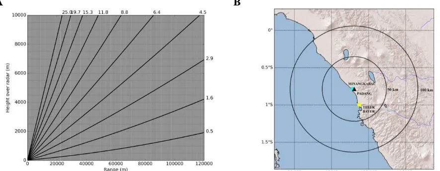
For this study, data collected from C-band radar in Minangkabau station (100.3°E; 0.79°S; 24 meter above ground level) during June 16, 2016 are used. The radar has a maximum horizontal coverage of 240 km, however, in this study the reflectivity data for up to 120 km radius only is used. This is to avoid the low quality reflectivity data, because at a great distance from radar, the signal received by radar is influenced by noise (Sebastianelli et al., 2010). Data are archived every 10 minutes in volumetric format which consist of 10 Plan Position Indicator (PPI) scans (0.5, 1.6, 2.9, 4.5, 6.4, 8.8, 11.8, 15.3, 19.7 and 25.0 degree elevation) (Figure 2A) and each of them contains the reflectivity values in decibel (dBZ with dBZ = 10log10Z).
3
Radar data processing and rainfall estimation were conducted using the open source library wradlib based on Python (Heistermann et al., 2013). Constant Altitude PPI (CAPPI) values were calculated for every 0.5 km from altitudes 0.5 to 5 km with horizontal resolution of 0.5 km/pixel. BMKG usually uses a parameter CAPPI-CMAX (maximum CAPPI values in altitude column) to analyze the extreme weather events. Therefore, we utilize dBZ values from CAPPI-CMAX to derive the rainfall rate estimates. Specifically, we extract dBZ values from 9 grid points closest to the ground rainfall stations and calculate their average values (dBZave) and maximum values (dBZmax). The instantaneous dBZave and dBZmax values at every 10 minutes interval are averaged into hourly and three-hourly values for each station. Rainfall rates estimation from the MP and RO relationships are compared with ground measured rainfall at the two stations to investigate their performances by calculating Root Mean Squared Error (RMSE) and Mean Absolute Error (MAE). In this study, the rainfall field is assumed to remain stationary in space and intensity during the sampling interval, where the raindrop is assumed to fall vertically downward (Mapiam et al., 2008). In addition, this event were also simulated by WRF model run by Center for Research and Development Center of BMKG (http://www.puslitbang.bmkg.go.id/wrf).
A B
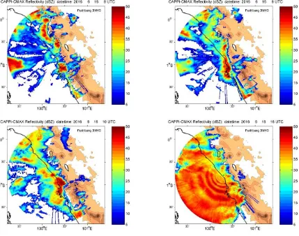
Figure 2. (A) PPI scan strategy of weather radar in Padang. (B) The Padang radar site (black triangle) and BMKG stations (circles) in West Sumatera.
3.
RESULTS AND DISCUSSION
4
A B
Figure 3. (A) Ground measured rainfall and (B) reflectivity radar data at Minangkabau and Teluk Bayur stations.
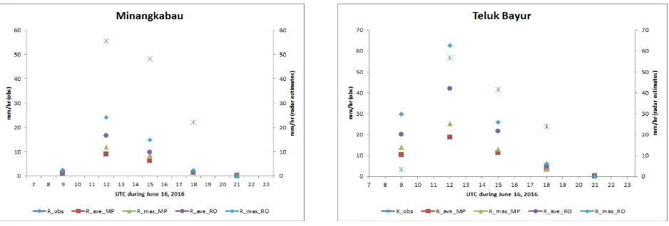
Figure 4. Reflectivity data (dBZ) from CAPPI-CMAX of Padang weather radar at 08, 09, 10 and 16 UTC on June 16, 2016. Brown color indicates topography contour using ETOPO2 with 2-minute resolution. Each contour line represents
an increase of 0.5km elevation.
5
Furthermore, radar-based rainfall estimations were closer to the observed values in Teluk Bayur than in Minangkabau. For instance, MAE values for R_ave and R_max with Rosenfeld relationship in Teluk Bayur are 14.2 and 11.0 mm/hr, respectively, while in Minangkabau, they are 19.8 and 17.4 mm/hr, respectively. This may be caused by the different distance between the stations and the radar site. Minangkabau station is located very close (~1-2 km) to the radar site where is poorly observed by the radar because there is no radar scanning on that range (Figure 2A). In contrast, Teluk Bayur station is located at ~25 km to the south of the radar site. This distance range is well observed by the radar through 10 PPI scans (Figure 2A). In addition, Table 1 also shows that Zmax is better than Zave in estimation of rainfall rates. The result show that both of MP and RO relationships still have large RMSE (15.9 - 29.6 mm/hr) and MAE (11 - 22 mm/hr) values. Therefore, this study suggests to conduct a follow-up research study to derive a new Z-R relationship that suits with radar reflectivity data in Padang. However, this will need a longer radar and ground observation dataset (Kamaruzaman and Subramaniam, 2012).
Figure 5. Comparison between ground observation rainfall and radar-based rainfall rate estimates at Minangkabau and Teluk Bayur stations. Note: R_ave_MP represents rainfall estimates derived from MP relationship with input Zave.
Table 1. RMSE and MAE between ground observation rainfall and radar-based rainfall estimates (in mm/hr)
Marshall-Palmer Rosenfeld
RMSE R_ave R_max R_ave R_max
Minangkabau 29.6 28.0 26.2 22.4
Teluk Bayur 23.8 21.6 15.9 16.2
MAE R_ave R_max R_ave R_max
Minangkabau 22.0 21.0 19.8 17.4
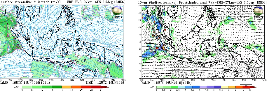
6 Figure 6. Model forecasts valid at 16 UTC on June 16, 2016 using WRF model run by Center for Research
and Development of BMKG
In addition to the comparison between radar-based rainfall estimates and ground observation rainfall, WRF model are also performed to forecast this extreme event. Sensitivity of WRF model has been performed to predict rainfall over West Sumatra (Febri et al., 2016). For this study, Figure 6 shows the WRF model forecast at 16 UTC on June 16, 2016 with initial condition at 12 UTC on June 16, 2016 for parameter wind and hourly precipitation. Comparing to Figure 4, WRF prediction at 16 UTC also shows a similar spatial rainfall pattern which mainly distributed over the ocean in the west of West Sumatra with intensity of 12 - 16 mm/hr and wind speed of 10-18 m/s. This predicted rainfall rate is still in comparison with radar-based rainfall estimates but underestimates the ground observation data (Figure 5). This may be caused by low spatial resolution of WRF model (~27km).
4. CONCLUSIONS
The extreme rainfall event on June 16, 2016 in West Sumatra which caused flooding in Padang and its surrounding area has been evaluated for its possible global and local causes. The meteorological data gathered during the event from radar reflectivity data in Padang city, ground observed rainfall at Minangkabau and Teluk Bayur stations and WRF model simulation have been used to investigate the event and to perform two reflectivity-rainfall rate relationships (Marshall-Palmer and Rosenfeld) in generating radar-based rainfall estimates. The results show that radar-based rainfall estimates generally underestimated the ground observation data with Rosenfeld relationship was better than Marshall-Palmer relationshio. The rainfall estimations were better in Teluk Bayur than in Minangkabau, possibly due to further distance from radar site which associated with more scanning data from the radar. This study suggests a follow-up research study to derive a new Z-R relationship that suits with radar reflectivity data in Padang, but this will need a longer dataset. In addition, WRF model were also performed to forecast this event.
5.
ACKNOWLEDGEMENTS
7
6.
REFERENCES
Febri, D. H., Hidayat, R., and Hanggoro, W. (2016). Sensitivity of WRF-EMS Model to Predict Rainfall Event on Wet and Dry Seasons Over West Sumatra. Procedia Environmental Sciences, 33, 140-154.
Heistermann, M., Jacobi, S., and Pfaff, T. (2013). Technical Note: An open source library for processing weather radar data (wradlib). Hydrology and Earth System Sciences, 17(2), 863-871.
Kamaruzaman M. A. and Subramaniam M. (2012). Rainfall estimation from radar data, Malaysia Meteorological Department (MMD), Ministry of Science, Technoloy and Innovation (MOSTI), Research publication no. 6/2012, pp. 1-16.
Mapiam, P. P., and Sriwongsitanon, N. (2008). Climatological ZR relationship for radar rainfall estimation in the upper Ping river basin. ScienceAsia J, 34(2), 215-222.
Marshall, J. S., Langille, R. C., and Palmer, W. M. K. (1947). Measurement of rainfall by radar. Journal of Meteorology, 4(6), 186-192.
Rinehart, R.E. (2010). Radar For Meteorologists (Fifth Edition), Rinehart Publications, 5, 136-139.
Rosenfeld, D., Wolff, D. B., and Atlas, D. (1993). General probability-matched relations between radar reflectivity and rain rate. Journal of applied meteorology, 32(1), 50-72.
Sebastianelli, S., Russo, F., Napolitano, F., and Baldini, L. (2010). Comparison between radar and rain gauges data at different distances from radar and correlation existing between the rainfall values in the adjacent pixels. Hydrology and Earth System Sciences Discussions, 7(4), 5171-5212.