THE SOCIETY EMPOWERMENT OF TANAH DATAR DISTRICT AT SINGKARAK LACUSTRINE AREAS USING THE INTEGRATED FARMING
SYSTEM, AGROFORESTRY AND AGROECOTOURSM
Azwar Rasyidin, Gusmini, Amrizal Saidi, Erigas Eka Putra, Hermansah, Irzal, Firmansyah, Yenni, Ellihasridas, Masrizal, Refdinal, Fashbir dan Sri Wahyuni
Universitas Andalas [email protected]
Abstracts
The program for society empowerment ( Sibermas) has done at sub districts of Batipuh Selatan district of Tanah Datar were conducted three kenagarians ( traditional village) ie, Guguak Malalo, Padang Laweh and Batu Taba. This program was intended to promote regional resources under university guidance. Singkarak drainage basin has known as the degraded land of West Sumatra, which parts of area conducted to District Solok and another are under district of Tanah Datar. Rainfall recorded shows that annual precipitation is less than 2000mm in the ranges 1600-.1850mm annually. However the mountaneous areas in the western part are wetter than the eastern parts. Due too the program were divided as for western part as sustainable village energy development by constructed micro hydro electric power and bio energy, and in the eastern parts which planted more bio fuel such as jatropacurcas and other plant such as pecan trees or cacao. Base on hydrological condition western part are possible do develop rice intensification combine with fish or fish pond. For this purpose Andalas University team promote all off activities and give guidance and technical assistance for those activities. Finally the region will promote as the ecotourism areas of West Sumatra
Key word, Agroforestry, Agrotourism, integrated farming, land degradation, society empowerment
.
Introduction
Singkarak drainage basin is the inland areas of the Indragiri catchment, this river flow from the Barisan range up to eastern coast of Sumatra at the Riau provinve. The areas was known as the degraded land of West Sumatra province. Singkarak and surrounding areas has agroclimatic zone D and E which lower annual precipitation and 3 or 4 consecutive dry month. Usually the month which deficit water is May, June, July and August, some time the water deficit also observed at February. Natural vegetation as the land cover are extremely poor. The western parts as the grouping for Sumani watershed which divided to 7 subwatershed covered by forested areas less than 23% from the total areas 59300 ha or 13536 ha is forest. The eastern parts almost no forest, the area conducted to subwatershed Bengkawas covered about 3800ha ( Ismal, et al 1996)
Masrizal, M.S. Ir. Refdinal, M.S. Prof. Dr. Fashbir HM Noer Sidin. Dra. Sri Wahyuni, M.Ed as the member.
The Singkarak lake is located at two district covered the areas 19390ha . Base of the administrative document of the Regional Development Planning (RTRW) district of Tanah Datar covered the areas 6420ha and district of Solok covered about 12970ha. The Singkarak drainage basin conducted 7 subwatershed covered areas about 59300ha that is Imang Gadang, Kuok, Partahunan, Paninggahan, Sumpur, Aripan, Lembang. The degraded land is about 26000ha which 20.000ha was located at the forested land status and 6000ha out of forested land status ( Rasyidin 2002).
Since 1973 the areas has been done for many activities both research and action plan for rehabilitate the degraded land that is;
1. Forestry Service Office (Dinas Kehutanan Provinsi) which the name Critical Land Rehabilitation proejct (RLKT) main program is replanting the hilly area which various trees.
2. Agricultural Service Office (Dinas Pertanian Provinsi) which the name of program Conservation farming system at critical land ( PPUKLK) which the main crop is the fruit trees.
3. Estate Service Office (Dinas Perkebunan Provinsi) which the nama Coconut for Rural Development program (PRPTE)
4. Rural people empowerment project at critical land under the program Land rehabilition project of critical land (ProLK) funding by West German ( GTZ) 5. Research Institution such as, Research center for spices crop, Research Center for
staple food, joint research of International Development Center of Japan and Andalas Irrigation studies Center (1997). And also JSPS Unand which Tokyo University of Agriculture ( 1995-1997)
6. Also action research done by Pusat Pengembangan Masyarakat joint activity ICMI and Directorat General RRL Ministry of Forestry. Which main activity Rural people empowerment for land rehabilitation at Tanjung Alai district of Solok.
Base on the amount of funding and time consume those activities didnot satisfied, there are not optimal results has achived. The size of degraded land not decrease but tend to increase. The main objective that the acitivities didnot solved the water shortage, in other side the rural people participation is low. In order to greening the area needed more rural people participation.
The objective of program for society empowerment.
a. To evaluate the social condition of rural people in relationship with integrated farming system program and land rehabilitation by use agroforestry method and their coordination among the farmer organization at the rural areas.
b. To study the cultural behaviour of the social tradition in their relationship with educational system, skill and knowledge to their comitment for farm management ability and environment sustainability program
c. To empower the rural people group for land rehabilitation using agroforestry system throughout agriculture, forestry and livestock farming.
d. To improve the farmer live standard by using biogass as the subsitution energi for wood and kerosine and promote organic farming to minimized farming depedency to the artificial fertilizer.
e. To improve knowledge and skill of the rural people to promote agroforestry and environmental management in order to promote Tanjuang Mutiara as the center of agro and ecotourism at the Singkarak Basin and surrounding areas. f. To improve knowledge and skill of rural people to manage the fresh water
ecosystem in the relation to the fish population both in the stream and lake system.
g. To established the planning and budgeting for develop rural people at g Singkarak Lake surroundign areas using the agroforestry, integrated farming system, and ecotourism.
Materials and Method
Physical condition of the areas
Singkarak drainage basin and surrounding areas.
The northern parts ie Sumpur Village consist of Lacustrine terrace coarse sediment, undulating slope ( 3-8%), Hillocks and Hill in random patern of acidic plutonic rocks. Most of the area is the stratovolcano intermediet tuff and lavas, volcano lower slope and foot slope, flat to sloping slope, ( slopes <16%) strongly dissected
Padang laweh village is consist of land unit, Lacustrine terrace coarase sediment (Aq 6.2.2), and volcanic mountains, intermediate tuff and lavas, mountaneous ( slope > 16%) strongly dissected.
[image:5.612.93.523.389.505.2]Guguak malalo consist of Lacustrine terrace coarse sediment ( Aq 6.2.2), Karst hard calcareous rocks mountain, steep to very steeps slopes (>25%) strongly dissected in elevation 500- 1285m. Mountain undifferentiate sedimentary rocks steeps to very steeps slope ( 25-75%), strongly dissected. Geologically the areas could be grouped to the very old geological formation ie Permian geological age, more oldest than Yura formation. In general the areas is unfertile except the area with aluvial and volcan system.
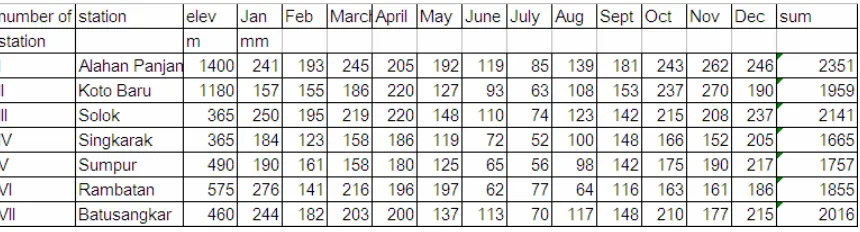
Table 1. The amount of precipitation of the Singkarak Basin from various meteorological station
affected by the precipitation from the Batipuh and X Koto subdistrict, while Batu Taba in the eastern parts is affected by Rambatan and Singkarak rainfall pattern.
Method
The program are divided at fourth main activities,ie; previous work, rural apraisal, action plan, reporting and evaluation. At the previous work team has collected all of the information from the library. Based on the discussion results of the desk study team proposed the short term activities planning. To know the detail of the rural potensial, the method of rapid rural appraisal has adopted. Action plan were definite after discussion with the district government office especially with the head of District Agricultural Service Office (DASO). The activities at the site mostly done by the extension method . in this activities the main target is the farmer group or social activities group.
Results and discussion
Related to the geomorphological and hidrological pattern acitivities is divided as two ie. The western parts is possible to develope as integrated farming system and ecotourism areas. The area will possible to develope as independence village especially in the rural enersi using the microhidroelectric power or biogass. While in the eastern parts is developed to the center of land rehabilitation using the estate crop and forestry. Jatropa curcas was selected as the crop which high suitability for the areas, as far as the areas have a shalow soil and dry climate.
The program for society empowermen of Singkarak basin is shown in the table 2
Table 2. Subsector and crop priority for society empowerment of Singkarak Basin Under district of Tanah Datar.
no Subsector priority
1 Ecoturism Rice filed, forestry and cultural heritage 2. Land
rehabilitation/agroforestry
Horticultura, /honey bee and cacao smallholder developent
3 Integrated farming Rice, horticulture, vegetable and fruit trees livestocks farming
4 Livestock farming Cow , water buffalow, goat/sheep, chieken
5 fishery Lacustrine fish, river and pond
Basic consideration for selected areas;
cooperation for promote agroindustry and agroecotourism, especially in the lower village income.
The Batipuh Selatan sub district will promote by district governmenr as the center for tourism..
The Tanjung Mutiara in Batu Taba Village located in the lacustrine line is grouping for lake and sea tourism program
Activities were conducted social approach district government office, subdistrict and people who lifes at the areas. At the previous planning the activities will be done at fourth subdistrict ie, Sub district Batipuh Selatan, Batipuh, Pariangan and sub dsitrict of Rambatan. Discussion with head of District Agricultural Service Office ( DASO) the activities is concentrate at sub district of Batipuh Selatan which conducted three tradisional village ( Kenagarian ie, Guguak Malalo, Padang Laweh and Batu Taba )
Explanation = fish pond as agrotourism center
Llocation of BPP Batipuh Selatan office
The map of , integrated farming system, and agrotourism at Padang Laweh
and one Social Intitutional for education Al Islam di Batu Taba. In our plan the Yayasan Al Islam will promote as the pionir for land. After one year past the number of farmer and fishermen participant increase more than 2 time ( see table 3) including the number of Social Institutional for Education Tuanku Lima Puluh at Guguak Malalo.
The farmer and fishermer group Puncak Pulau and Taratak Hulu has three activities, do the farming system to produce staple food, fishing in the lake Singkarak and their also promote the fresh water pond in the hilly areas for develop fresh water fish. The pond located at the inland areas of Banda Jao stream (see the map)in the areas about 10ha. The funding for activities of two group are supported by H Armaini who the succesfull merchandize and have the intension to promote the rural economic.
The amount of water flow is enough to produce electric power in the value 4000 KVA. The fish pond are located near to the hilly areas where the animal as the fish predator lived there. Those animal movement always in the night, to keep the fish pond out from predator, the area at surrounding pond should be lighted, so is needed electric power. In order to keep out the fish pond from predator one set of microhidro electric power has established here. As far as the farmer almost no experiences for fish pond because they are more familiar for fishing at the lake surface. Ind order to the real condition the farmer and fishermer group needed more guidance to motivate the group .
The problem for develop fish pond program is a. Feeding
b. Fish breeding c. Slow growing d. Marketing
e. Govermenment supporting policy f. No electrictricity power
g. Technological transformation.
Base on the site problem we setting up extension program. First priority is feeding, training for technological transformation of fish feeding has done conducted by fourth farmer and fishermer group one farmer group and one the Institution education at rural level. The goverment district office supported by prepare one set of fish food processing machine at the end of November 2008. for prepare the fish feeding, so many materials are not available in the site. We tried to promote the alternative material but this rather difficults compare to buy the fish feeding.
Before developed fish pond the group in their activities are the fishing at the lake surface, rural people as the farmer used their time 30% for farming and other for fishing, but now condition already changed . The surrounding lake or near the coastal lake is known as the spesific rural areas which the main livlihood of resident is fishing and farming. The kind of fish in Singkarak lake is Bilih ( Mystacoluecus Padangensis BLkr) this kind of fish is originate from Singkarak lake , an others kind of fish are Asang (Osteochilus brachinopterus), Turiek (Cyclocheilichtys spp de Zwani) and sasau (Hampala spp). Since the Singkarak hidroelectric power was operated in 1988 the natural condition of lake ecosystem already changed.
balances between precipitation, evaporation and water flow. Natural water balance has reported by Ismal et all ( 1996) in their tesis they mention that the water are belance between the input and output which the annual average of run off percentage is 62%. The annual average of water discharge at ombilin 43.9m3/sec, the data from 1973-1981 shown that debit are fluctuated which the maximum discharge 111.1 m3/sec and minimum discharge 6.9m3/sec. The discharge value are in the range of run off prediction by Ismal et al in the range 32-66:62)%. Disruption of natural condition was observed since the water outflow to Anai watershed in the value 57.3 m3/sec in order to produce electric power. Comparing the outflow to electric power with the natural flow to Ombilin river were observed the value minus 13.4 m3/sec or equivalent which the rainfall 5.97mm/day. In order to support the amount of water discharge for electric power the natural condition changed become artificials. In the rainy season water in the Ombilin river closse to increased the water volume in the storage, this cause the water level is higher and in the dry season the water level become lowest. The artificial condition is not favorable for lacustrin ecosystem.
The change in the surface water level of the lake was affected ruinous of some of the lacustrin vegetation. The natural coastal lake vegetation in the local name is
Dalu-dalau is the kind of mangrove is rather difficult to observed along the shoreline compare
to the condition on 1998. Syandri 2008 has reported. Changes in the lacustrin ecosystem also affected the quality and quantity of fihshing yields drastically. In 1998 the size of Bilih in the average 19 cm long, but afte ten year the average 3-6cm
In order to survive the fisher and farmer group was adopted transformational technologi. They want to changes their habit from the fishing to farming by developed fish pond. Two of farmer and fishermer group Taratak Hulu and Puncak Pulau become the pionir to fish pond at the mountaneous and hilly areas. Those group has funded by H Armaini whos the indigeneous people which the main livelihood as the inter island traders.So numerous farmer and fishermer group exist in the Singkarak Basin, and the people such as H Armaini is to limited, frankly speaking the people in the shore line has the great hope to live under beneficient of the lake.
The fish pond of farmer and fishermer group located at hilly and montaenous areas about 650m from sea level. The location has the nice scenery and possible to developed as the place for tourism. In order to developed as the place for agroecotourism the nearest to the fish pond has equipped with another facilities, parking place, restourant and swimming pool. To promote the agroforestry and agrotourism the group already planted the citrus auranti folia as the agroforestry crop.
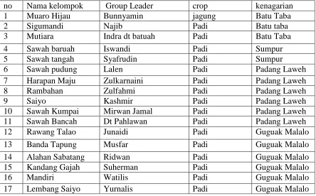
number of farmer group increases compare to the fiscal year 2008/2009 with 2009/2010. The name, group leader and the kind of crop selected by the group. Every group usually has 20 person active member.
Table 3. The farmer and fishermer group for stapel food production using the System of Rice Intensification
no Nama kelompok Group Leader crop kenagarian
1 Muaro Hijau Bunnyamin jagung Batu Taba
2 Sigumandi Najib Padi Batu taba
3 Mutiara Indra dt batuah Padi Batu Taba
4 Sawah baruah Iswandi Padi Sumpur
5 Sawah tangah Syafrudin Padi Sumpur
6 Sawah pudung Lalen Padi Padang Laweh
7 Harapan Maju Zulkarnaini Padi Padang Laweh
8 Rambahan Zulfahmi Padi Padang Laweh
9 Saiyo Kashmir Padi Padang Laweh
10 Sawah Kumpai Mirwan Jamal Padi Padang Laweh
11 Sawah Bancah Dt Pahlawan Padi Padang Laweh
12 Rawang Talao Junaidi Padi Guguak Malalo
13 Banda Tapung Musfar Padi Guguak Malalo
14 Alahan Sabatang Ridwan Padi Guguak Malalo
15 Kandang Gajah Suherman Padi Guguak Malalo
16 Mandiri Watilis Padi Guguak Malalo
17 Lembang Saiyo Yurnalis Padi Guguak Malalo
Conclusion
The program for society empowerment ( Sibermas) has done at Sub district of Batipuh Selatan, District of Tanah Datar for two fiscal years. 2008/2009 and 2009/2010. the program has more success in the western parts compare to eastern parts. Geological factor especially the hydrological factor is better in western parts, more wetter and possibly to develop farmer and fishermer group which cultivate staple food crop such as rice and corn. The number increasing of group farmer and fishermer in the western parts is indicate that System of Rice Intensification ( SRI) and integrating farming system or organic farming are possible to develop at the western parts compare to eastern part. The mountaneous and hilly areas in the western parts is forested areas, and there are many small stream originated from there. The existence of stream has strong relationship with the fishing of Bilih ( Mystacoluecus Padangensis BLkr) by tradional method ( Alahan). The Yield of alahan are depend to the amount of water flow from the mountaneous, even the water not so fluctuated the yield is relatively constant.
Base on the historical and sociological factor, the rural people in the shore line of Singkarak basin has the strong dependency to the lake. We proposed for the future the activities of farmer and fishermer group should be focused for fresh water ecosystem, while an other activities were function to support the ecosystem work.
The eastern parts as their located in the Trans Sumatra Highway, and also has the railway. The areas possibly to develop as the location of agro ecotourism and for marketing the fresh water product. However, land rehabilitation program using the trees will possible to solved the water shortage at the mountaneous and hilly areas.
References
Berlage, Jr., 1949; Regenval in Indonesia, Departement van Verkeer, Energie en Mijnwezen, Meteorologisch en Geophysische Dients. Koniklijk Magnetisch en Meteorologisch observatorium te Batavia, Verhandlingen No.37, 210pp.
Burt, T.P. and Butcher, D.P., 1985; Topographic controls of soil moisture distributions, J. of Soil Sci. 36:469-486.
Daras, U dan A.Ruhnayat. 1990 Potensi Sumber Daya Lahan di Sekitar Danau Singkarak Untuk Pengembangan Tanaman Industri dan perkebunan . Dalam Azmi Dhalimi Dkk (ed), 1990, Komunikasi ilmiah Pengembangan Tanaman Industri dan perkebunan pada Lahan Kritis Sekitar Danau Singkarak- Sumatera Barat ( Prosiding) Solok 5-6 September 1990.
Hakim, N, Ismal, G., Mardinus dan Muchtar, H., 1993. Perbaikan lahan kritis dengan rotasi tanaman dalam budidaya lorong, Simposisum Pennelitian Tanaman PanganIII, pusat Penelitian dan Pengembangan tanaman Pangan Bogor 23-25 Agustus 1993.
Ismal, G., Rasyidin, A., Arief,A. and Syahni, R., 1996. Land rehabilitation and development of Upland Ecosystem, A case Study of Singkarak drainage Basin, West Sumatra, Indonesia. Tokyo University Of Agriculture
Kamaludin, R, 1990. Program Pembangunan Wilayah di Sekitar Danau Singkarak, Sumatera Barat. Dalam Azmi Dhalimi dkk (ed), 1990, Komunikasi ilmiah Pengembangan Tanaman Industri dan perkebunan pada Lahan Kritis Sekitar Danau Singkarak- Sumatera Barat ( Prosiding) Solok 5-6 September 1990.
Nurdin, F. 1990. Peluang dan peranan Pengembangan Tanaman Perkebunan di Sekitar Danau Singkarak. Dalam Azmi Dhalimi dkk (ed), 1990, Komunikasi ilmiah Pengembangan Tanaman Industri dan perkebunan pada Lahan Kritis Sekitar Danau Singkarak- Sumatera Barat ( Prosiding) Solok 5-6 September 1990.
Oldelman,L.R., Irsal Las, and Darwis, S.N., 1979.; An Agroclimatic Map of Sumatra. Contr.Centr.Res. Ins.Agric. No.52, Bogor, 35pp
Rasyidin A, 2002. Pengaruh Manusia Terhadap Degradasi Lahan. Jurnal Penelitian Andalas no 38/Mei/tahun XIV/2002.
Syandri H, 2008. Ancaman terhadap plasma nutfah ikan bilih, Pidato pengukuhan profesor.
Tim Pengkajian sosial ekonomi masyarakat sekitar Kerinci, 1997. Laporan akhir kerja sama Partisipasi ICMI dalam rangka pengkajian sosiial ekonnomi masyarakat sekitar kerinnci, Direktorat jendral Reboisasi dan rehabilitasi lahan Departemen kehutanan RI.
! "
! # !
$ % ! ! ! & ' !
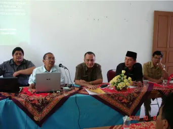
Figure 3. General meeting at Batipuh Selatan sub district office , Oktober 8 2008
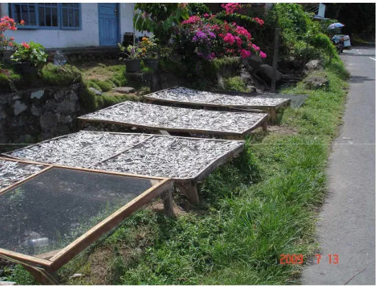
[image:14.612.90.432.397.652.2]Figure 4. Tradional ways for fish drying