Paper presented on international Seminar on 7th Asian Regional Conference, 26-28 June 2012, Adelaide, Australia. Contact: SANE Events for Irrigation Australia Limited (IAL), (Incorporating IACID, Irrigation Australia's Committee on Irrigation & Drainage),
Quantified and spatially analysed land characteristics to
Develop Water Management Zoning in the downstream
area of Musi River Basin in south Sumatra Indonesia
Paper presented on international Seminar on 7th Asian Regional Conference, 26-28 June 2012, Adelaide, Australia. Contact: SANE Events for Irrigation Australia Limited (IAL), (Incorporating IACID, Irrigation Australia's Committee on Irrigation & Drainage),
Quantified and spatially analysed land characteristics to Develop
Water Management Zoning in the downstream area of Musi
River Basin in south Sumatra Indonesia
Imanudin, M.S.1 A Muis 2, and Sukoco2
1)
Lecturers at Soil Science Department, Faculty of Agriculture, Sriwijaya University Sriwijaya University. Campus of Unsri Indralaya Km 32 Indonesia
2
Senior staff at directorate general water resources Ministry of Public Work Indonesia Telp/Fax 62711580 460; 313247
Email: [email protected]
Abstract
The objective of the study is to construct the land suitability for developing agricultural water management zoning in the downstream area of Musi River Basin. Development of land suitability map was constructed from the results of land quality characteristics data at Delta Telang Banyuasin areas that had been quantified and spatially analyzed in the form of geographical information consisting of land topography, high tide water overflow potential, land drainage potential, pyrite layer depth, soil type, salinity intrusion and land use. The water management recommendation that was also known as water management zone map can be developed from land suitability map. The water management zones in Saleh areas were identified as a water management zones of tidal water rice-second crops, rain-fed rice-second crops, and annual crops/trees.
Keyword: land characteristics, water management zoning, downstream, Musi river basin
1. Introduction
Paper presented on international Seminar on 7th Asian Regional Conference, 26-28 June 2012, Adelaide, Australia. Contact: SANE Events for Irrigation Australia Limited (IAL), (Incorporating IACID, Irrigation Australia's Committee on Irrigation & Drainage),
management on farm level would have significant effect on land productivity improvement.
Concept of Water Management Zoning (WMZ) is different than that of land suitability class mapping for agriculture. In land suitability concept for agricultural commodities, land is classified based on land unit group with consideration to the unrecoverable main limiting factor. This condition gives possibility for all land units to be spatially represented on map Suryadi, 1996 [6] and Schultz [9]. Although WMZ had no land unit map, but it had spatial distribution of each land attributes. The most dominant value of land attribute will be used as reference and characteristic of land unit for basic consideration in order to compose water management zoning. Land unit limit in WMZ is one tertiary block because it will facilitate water table control operation in the field. Therefore the objective of the study is to construct the land suitability for developing agricultural water management zoning, on the basis of land characteristics.
2. Methodology
This study was conducted at tidal swamp reclaimed area of delta Telang covering 26,680 ha study area (Figure 1). Soil sampling for soil fertility analysis was conducted by using controlled random sampling method through land typhology approach. Field observations were consisted of coordinate data gathering, watertable depth observation, and land utilization.
GIS technology was used to analyze several land characteristics through overlay technique which produced land units that is subsequently adjusted to land utilization plan. Land utilization plan is used to produce water management recommendation on each secondary blocks. This water management plan was produced from field adaptation results of DUFLOW-DRAINMOD model. The use of LANSAT TM7 satellite image was to update the existing land use data. The last data updating was done by using CITRA LANSAT in 2008.
Paper presented on international Seminar on 7th Asian Regional Conference, 26-28 June 2012, Adelaide, Australia. Contact: SANE Events for Irrigation Australia Limited (IAL), (Incorporating IACID, Irrigation Australia's Committee on Irrigation & Drainage),
Figure 1. Situation map of study area.
Group Design for Water Management Zoning in tidal lowland agriculture in the area study can be clasified as folow as:
Area 1: High tide irrigation-water retention: Paddy field rice of tidal swamp irrigation at land unit I group, soil water depth below 30 cm
Area 2: High tide irrigation and flushing or draining: Rainfed paddy field rice-second crops, drainage 30-60 cm.
Area 3: Rainfall water retention and high tide water: Paddy field rice-second crops/trees, drainage > 60 cm
3. Results And Discussions
3.1. Quantification and Spatialization of Land Characteristics
Paper presented on international Seminar on 7th Asian Regional Conference, 26-28 June 2012, Adelaide, Australia. Contact: SANE Events for Irrigation Australia Limited (IAL), (Incorporating IACID, Irrigation Australia's Committee on Irrigation & Drainage),
distribution within area scale (Telang). Satellite image of Lansat 2002 and 2008 had been used to carry out data updating, whereas land use distribution can be composed through geometric correction and field calibration (Figure 2).
The largest land use distribution is for rice, especially at Primary 6, 8 and 10. Part of land at Primary 3 and 5 have been utilized by the community members for coconut plantation. It is expected that water management improvement at primary 8 would encourage the community members to change their coconut plantation into rice crops. This trend is starting to emerge such as shown by some of the community members at primary 5 and 3 that had cut their coconut trees.
Figure 2. Land Use distribution
Paper presented on international Seminar on 7th Asian Regional Conference, 26-28 June 2012, Adelaide, Australia. Contact: SANE Events for Irrigation Australia Limited (IAL), (Incorporating IACID, Irrigation Australia's Committee on Irrigation & Drainage),
example of land capability distribution to drain water during rainy or wet condition can be seen in Figure 3.
Naturally water drainage potential for more than 60 cm below soil surface was found at west areas of Primary 8 and 10. This condition has important effect if land is utilized for rice crops planting. Water conservation measure is needed for land in order to prevent quick water lost.
Excessive deep drainage should be avoided because it has effect not only on crops, but also on the risk possibility of pyrite oxidation below soil surface. Therefore, water level in channels should be kept at certain depth below soil surface depending on rainfall and pyrite layer depth (shallow or drainage control).
Figure 3. Land drainability distribution
Drainage is also required to prevent toxic elements accumulation in soil at tidal swamp area by applying high organic matter compounds. Drainage problem become more important than water retention. It implies that rice growth during cropping season at dry paddy field by using soil water requires watertable elevation located several meters below soil surface. Results of in-depth field study showed that leaching was the proper alternative because it produced increase in production at delta Telang demonstration plots.
Paper presented on international Seminar on 7th Asian Regional Conference, 26-28 June 2012, Adelaide, Australia. Contact: SANE Events for Irrigation Australia Limited (IAL), (Incorporating IACID, Irrigation Australia's Committee on Irrigation & Drainage),
is consisted of first class having less than one month period, second class having 1-2 month period, and third class having 2-3 month period. Distribution of salt water intrusion was shown in Figure 4. Field observation showed that salinity hazard can be minimized by water structures operation. This was proven from field study at Primary 8 Telang Karya. Salt water was flown into this area at the end of August and September. Water gates operation is capable to hold high tide water containing the salt water. However, land can not receive water supply if salt water intrusion period was more than one month which made soil water will drop up to critical limit for crops. Therefore, this land characteristic component is the main part in composing of water management zoning plan.
Figure 4. Salt water intrusion
Paper presented on international Seminar on 7th Asian Regional Conference, 26-28 June 2012, Adelaide, Australia. Contact: SANE Events for Irrigation Australia Limited (IAL), (Incorporating IACID, Irrigation Australia's Committee on Irrigation & Drainage),
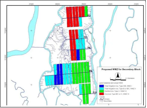
Figure 5. Land suitability distribution
3.2. Developing Water Management Zoning
Water management needs are different for different soil types and land use. Wetland rice needs inundated fields with the possibility for leaching, while second crops require stable water table at the depth well below the surface. Two basic options are available for leaching and flushing of the root zone and improving adverse soil water-conditions in tidal lowland area Boussevain [2]. Soil and water management aspects in relation to water management options can be seen in Table 2.
Paper presented on international Seminar on 7th Asian Regional Conference, 26-28 June 2012, Adelaide, Australia. Contact: SANE Events for Irrigation Australia Limited (IAL), (Incorporating IACID, Irrigation Australia's Committee on Irrigation & Drainage),
distribution for water control plan at each secondary blocks can be seen in Figure 6.
Figure 6. Map of water management zoning distribution in the area study
Each secondary blocks from Figure 10 showed water management technical recommendation and land use recommendation. Operational plan of watertable control system from each secondary blocks is also different, but it forms a management unity from each secondary block units. Therefore, one irrigation technician should be available to operate the irrigation network in collaboration with one Farmer Organization of Water Management (P3A).
Paper presented on international Seminar on 7th Asian Regional Conference, 26-28 June 2012, Adelaide, Australia. Contact: SANE Events for Irrigation Australia Limited (IAL), (Incorporating IACID, Irrigation Australia's Committee on Irrigation & Drainage),
Table 2. Recommendation for each water management zoning at tidal lowland
Water management zoning is closely related to the land suitability of an area, land use planning and decision making process. If the area will be developed for irrigated wetland rice, second crops or trees, or a combination of crops, then water management systems for the area can be designed which is based on the water management zoning.
Water management planning should applied in the field level; system level and delta level. Government should organize in the system and delta level while farmer could handle in the field level which is organized by water user association.
3.3.1. Field level
The field level is the smallest water management unit and the ‘heart’ of the
irrigation and drainage system is field plot. In Indonesian tidal lowlands, it is
Paper presented on international Seminar on 7th Asian Regional Conference, 26-28 June 2012, Adelaide, Australia. Contact: SANE Events for Irrigation Australia Limited (IAL), (Incorporating IACID, Irrigation Australia's Committee on Irrigation & Drainage),
yard’ for living, fruit and vegetable growing purposes. Based on its land suitability, the water management strategy at field level should be focused in maintaining water layer at the field for wet wetland rice, or groundwater table at an appropriate depth for second crops or trees having particular hydro-topographical, soil, climate and land use conditions.
It means that water management systems should permit an adequate outflow of excess field water and toxic elements in order to maintain an optimal root environment for crop growth. If additional water supply should be obtained (tidal, or low lift pump irrigation), then a careful plan should be made related to the planning and operation (limited high water period and topographical conditions). For hydro-topographical class A and B areas, gravity flow can be expected to maintain a certain water depth in the tertiary canals, but this is almost impossible for class C and D. Therefore, another alternative should be applied in later case (irrigation, flushing canal from upstream or application of low lift pumps Suryadi, [6]. Simple systems should be considered where water is entered into the network of water courses and subsequently farmers may withdraw the water into their field by gravity or using low lift pumps. If the water management systems at field level are poorly maintained, then the drainage system will not properly function.
3.3.2. System Level
The performance of the system level is highly depended on the condition at field level. Although the drainage capacity of the secondary and primary canals is sufficient, but the drainage system will not properly function if the tertiary drains are poorly maintained.
Paper presented on international Seminar on 7th Asian Regional Conference, 26-28 June 2012, Adelaide, Australia. Contact: SANE Events for Irrigation Australia Limited (IAL), (Incorporating IACID, Irrigation Australia's Committee on Irrigation & Drainage),
3.3.3. Delta Level
The water resources system in a delta is a production system which produces water and water related goods and services. It is part of the natural systems or ecosystem which included all physical, chemical and biological components and corresponding processes and interactions. The development strategy of a delta as a system should be integrated (all relevant aspects), practical and feasible (in terms of financial, environment, social, legal, technical and management means) and should produce a balance on the development of systems which are located in the delta. Specific matter related to the impacts of a development strategy on water levels and salinity intrusion in the delta area should carefully be considered. By comparing the with and without development options, then the impacts of development can be assessed.
4. Conclusions and Recommendations
Water management needs are different for different soil types and different types of land use. Wetland rice requires inundated fields with the possibility for leaching, while second crops need stable water table at depths well below the surface. Two basic options are available in tidal lowlands for leaching and flushing of the root zone and improving adverse soil water-conditions. The two options involve the water supply option for leaching and flushing of wetland rice as well as the drainage options for second crops and trees (leaching of root zone during high tide and flushing during low tide).
Hydro-topographical conditions should be used as the starting point to analyze the suitability of tidal lowland areas. By considering potential tide irrigation and drainage of the area, implicitly the water balance of the area related to particular crops is considered. This water management zoning can be used as the base for sustainable development of the tidal lowlands. Modeling by applying a GIS is a useful and powerful tool for supporting different activities (planning, design and operation) at different levels (field, system or delta).
Recommendation for each water management zones was also refer to study result and model adaptation in the field. There was four water management zones consisting of two times rice crop-second crops planting (rice-rice-corn pattern), rice-second crops, rainfed rice-second crops, and second crops-trees.
Paper presented on international Seminar on 7th Asian Regional Conference, 26-28 June 2012, Adelaide, Australia. Contact: SANE Events for Irrigation Australia Limited (IAL), (Incorporating IACID, Irrigation Australia's Committee on Irrigation & Drainage),
[1] Bengston, R. L., . Garzon, R.S and Fouss. J.L. 1993. a fluctuating water table model for the management of a controlled-drainage/sub irrigations system. transaction of the asae. 36(2): 437-443. evaluation using computer model Duflow, in tidal lowland reclamation areas for supporting fishpond. supporting paper in the symposium of water for fishery in Indonesia. Palembang, 27-29 Juli 2004
[4] Imanudin, M.S., and Susanto, R.H. 2005. The use of pedotransfer function for computer simulation (budget) model for water balance analysis in rooting Zone. Trofical Soil Journal. Department of Soil Science Lampung University 11(1) December 2005. ISSN 0852-257x.
[5] Imanudin, M.S. Armanto, E., Susanto, R.H., Masreah, B. 2009. The Use Of Drainmod Model For Developing Strategic Operation Of Water Management In The Tidal Lowland Agriculture Areas Of South Sumatra Indonesia. Paper presented in international seminar on wetlands and sustainability Kinibalu Malaysia, 26th-28th June 2009. Development Projects. Paper Presented in the Technical Meeting on Water Management Zoning and Application of GIS Related to Tidal Swamps Development. Ministry of Public Works, Jakarta. Indonesia.