M odu le 6 – ( L2 2 – L2 6 ) :
“
Use of M ode r n
Te ch n iq e s in W a t e sh e d M a n a ge m e n t ”
Te ch n iqu e s in W a t e r sh e d M a n a ge m e n t ”
Applica t ion s of Ge ogr a ph ica l I n for m a t ion Syst e m a n d Re m ot e Se n sin g in W a t e r sh e d M a n a ge m e n t , Role of g g , D e cision Su ppor t Syst e m in W a t e r sh e d M a n a ge m e n t
2 5
I n t e gr a t e d W a t e r sh e d M ode lin g Usin g N u m e r ica l M e t h ods GI S &1 1 1 1
2 5
Usin g N u m e r ica l M e t h ods, GI S &L25
L25–
Integrated Watershed Modeling Using
l
h d
G S &
S
Numerical Methods, GIS & Remote Sensing
Topics Cove r e d
Topics Cove r e d
Integrated watershed modeling; Numerical Integrated watershed modeling; Numerical
methods; Finite element method; Computer methods; Finite element method; Computer methods; Finite element method; Computer methods; Finite element method; Computer modeling; Geographical Information System; modeling; Geographical Information System; R i A li i i W h d R i A li i i W h d Remote sensing; Applications in Watershed Remote sensing; Applications in Watershed Management.
Management.
Keywords:
Keywords:
Integrated watershed modeling, numerical Integrated watershed modeling, numerical modeling; GIS; Remote sensingmodeling; GIS; Remote sensing..
2 2 2 2
modeling; GIS; Remote sensing modeling; GIS; Remote sensing..
Necessity of Integrated Catchment/
Necessity of Integrated Catchment/
Watershed Based Modeling
Watershed Based Modeling
Watershed Based Modeling
Watershed Based Modeling
Water resources management- catchment/ watershed based
Watershed / catchment based- Watershed modeling-Planning & management
Catchment/ Rainfall – runoff Catchment/ Rainfall runoff
Modeling based on physical laws – Importance, necessity
An integrated catchment/ watershed model An integrated catchment/ watershed model. Hydrological Processes- Infiltration, Runoff, evaporation etc.
Digital revolution
Recent advances in watershed modeling -Use of
numerical modeling, remote sensing and GIS.
3 3
g, g
I n t e gr a t e d W a t e r sh e d M ode lin g Appr oa ch
I de n t ifica t ion of spe cific h ydr ologic pr oble m
D e sign s of GI S ( da t a la ye r s & a t t r ibu t e s) & RS D e sign s of GI S ( da t a la ye r s & a t t r ibu t e s) & RS
D a t a ba se bu ildin gg D a t a Pr oce ssin gg
Se le ct ion of h ydr ologic m ode l a n d for m u la t ion u sin g n u m e r ica l m e t h ods
M ode l com pu t a t ion s
4 4
Com pa r ison of r e su lt s
Hydrologic/ Hydraulic Modeling
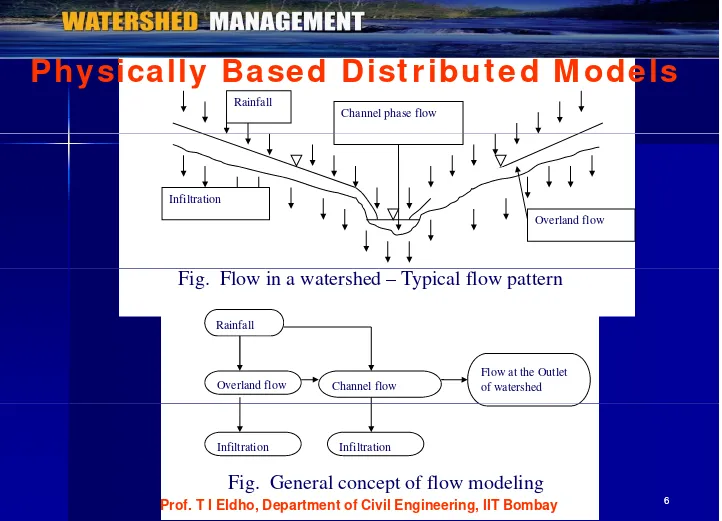
D iscu ssionPh ysica lly Ba se d D ist r ibu t e d M ode ls
Rainfall
Channel phase flow
Ph ysica lly Ba se d D ist r ibu t e d M ode ls
Infiltration Infiltration
Overland flow
Rainfall
Fig. Flow in a watershed – Typical flow pattern
Flow at the Outlet of watershed Channel flow
Overland flow
Infiltration Infiltration
6 6
Fig. General concept of flow modeling
Remote Sensing, GIS & Numerical Methods
Re m ot e se n sin g
The remote sensing data are capable of solving the problem of scarcity of data.
Spatial variation Temporal variation
Re m ot e se n sin g pr oce ss
1. Data acquisition 2. Data analysis
Remote sensing - Capability of observing several
hydrological variables - Over large areas on titi b i
7 7
Geographic Information Systems (GIS)
Com pon e n t s of GI S
1. Data input data
2. Storage and management
3. Data manipulation and analysis 4 D t t t
4. Data output
System data storage and management and management
Data Manipulation
Data Input for p Data Output for and analysis
p system
p system
User Interface - GUI
8 8 Prof. T I Eldho, Department of Civil Engineering, IIT Bombay
Numerical Methods – Computer Models
Conceptual modeling Mathematical modeling
M h i l bl l d b
Mathematical problems - solved by
arithmetical operations.
Digital revolution- the role of numerical Digital revolution- the role of numerical
methods
Computer models – various modelsp
Numerical methods
(a) finite difference method (b) finite element method
(c) finite volume method
9 9
Selection of
Watershed Data collection for watershed Mathematical formulation of model
Remotely Sensed data & GIS
Preparation of Thematic maps
Numerical Formulation GIS
Model development development
Testing and Evaluation of Model
Integrated Use of Numerical Method GIS & Finalization of model
10 10 Integrated Use of Numerical Method, GIS &
Watershed Based Runoff modeling
fil i i d l
I nfiltration – Various models
Overland flow - One dimensional/ 2D
Channel flow - One dimensional
Channel flow - One dimensional
Component models coupled to get the runoff
Rainfall
Channel flow
Infiltration
O l d fl Overland flow
I n filt r a t ion
I n filt r a t ion
Eg. Philip Infiltration Model: To calculate infiltration rate and subsequent excess rainfall
The rate of infiltration is given by
1 1 / 2
1 2
i
f s t K f potential infiltration rate i
s infiltration sorptivity
K hydraulic conductivity
1/ 2
Infiltration sorptivity K
3
s
K saturated hydraulic conductivity
ini
s initial (uniform) soil saturation degree
pore size distribution index
d diffusivity index ( )d (1 2 ) /
12 12
saturated matrix potential of the soil
( ,d sini)
Physically based Model
Physically based Model
Governing equations for surface runoff
Governing equations for surface runoff
1.Overland flow (Two dimensional) C ti it ti
a. Continuity equation
i
b. Momentum equation
Physically based Model..
Physically based Model..
( ) 02 Channel flow (One dimensional)
43h
fy
3
h ( ) ( )
2.Channel flow (One dimensional)
a. Continuity equation
0
(7)
Physically based Model…
Physically based Model…
b. Momentum equation
y Governing equation for ground water flow
Gove r n in g e qu a t ion s for ove r la n d flow ( D iffu sion
q flow per unit width
h depth of flow
e
r excess rainfall intensity
2 . M om e n t u m e qu a t ion
S slope of overland flow plane
f
S friction slope of flow plane
Fin it e e le m e n t for m u la t ion - Ga le r k in ’s cr it e r ion is
u se d
tt t t t t t t t
C h tt C h t t B (1)qt qtt t f (1)( )re t ( )re tt
F diff i d li
is the factor that determines the type of finite difference scheme involved (0.5)
i i
For diffusion wave modeling
16 16
i and k represent successive nodes in flow direction
L length of element
Gove r n in g e qu a t ion s for ch a n n e l flow
The equation of continuity
Q A
Q is discharge in the channel, A is area of flow in the channel,
Momentum equation
S is bed slope of channel
c
f
S is friction slope of channel
R is hydraulic radius ( A P/ ) P is wetted perimeter
n is channel flow Manning’s roughness coefficient Fin it e e le m e n t for m u la t ion
For diffusion wave modeling
17 17
L
Start
I t E i f ll f i filt ti d l d d ti N b d i f l t Input: Excess rainfall from infiltration model and duration, Number and size of elements, Roughness coefficients, Slopes, Bed width, Time step, Duration of simulation etc.
Initialization of variables
(Initialize nonzero depth at time t=0)
Calculation of element matrix for channel and overland flow
Generation of global matrix by assembling element matrices and applying boundary conditions for channel and overland flow
Solving the system for overland flow
If
Solving the system for channel flow
No
M ode lin g Pr oce du r e
Data collection for the selected watershed. Mathematical modeling
Mathematical modeling.
Numerical formulation for the mathematical model. Preparation of thematic maps of the watershed by
using
Remote sensing imageries and GIS.
Development of software for the formulated model
Development of software for the formulated model. Testing and evaluation of the model for different
rainfall events
Finalization of model.
Modeling Procedure…
Discretization as rectangular strips
Channel network in
1 Overland flow
the watershed
Channel meeting
point 4
3
2 1
2
3
4
element node
Overland flow strip Single discretized channel with overland flow adding at channel nodes
W
4
L
Overland flow element
W L
20 20
Example
Example ofof ChannelChannel flowflow modelmodel:: DiffusionDiffusion wavewave modelmodel ( Aral( Aral etet alal.. 1998
1998)) ..
Example
Length of each branch = 5,000 m; channel g , ; width is 50 m for two upstream channels & 100 m for d/s channel. Bed slope is 0.0002. Roughness coefficient is 0.025.
Ca se St u dy:
Khadakhol Watershed
(V k R dd 2007) (Venkata Reddy, 2007)
Location- Nashik district, Maharashtra, India
E t L it d f 73 17' d 73 20' East Longitudes of 73o 17' and 73o 20'
North Latitudes of 20o 07' and 20o 09'.
Area- 5 89 km2
Area 5.89 km
Major soil class – Silty loam
Remotely sensed data- IRS 1D LISS III image Jan.13,1998 Thematic maps - Drainage, Slope and LU/LC, DEM
Case Study: Rainfall –Runoff Modeling
D a t a ba se pr e pa r a t ion
Drainage m ap: Initially scanned topographical maps of the Drainage m ap: Initially scanned topographical maps of the
area in 1:25000 scale are registered in ERDAS IMAGINE software. Watershed boundary and the drainage maps are digitized in ArcMap
digitized in ArcMap.
Slope m ap: Contours with 10 m interval of the watershed
are digitized in ArcMap from topographical maps and Digital Elevation Model (DEM) with 100 m cell size has been
Elevation Model (DEM) with 100 m cell size has been generated using TOPOGRID option of ArcInfo software.
LU/ LC m ap: Remotely sensed data of IRS 1D LISS III path
105 and row 55 of January 13 1998 has been used to 105 and row 55 of January 13, 1998 has been used to
extract LU/ LC of the watershed. LU/LC map is derived from remotely sensed data of watershed by supervised
classification using ERDAS IMAGINE software
23 23
classification using ERDAS IMAGINE software
Land Use/Land Cover map
False Colour Composite p
False Colour Composite
Kh a da k oh ol W a t e r sh e d
Digital Elevation Model map
24 24
8
August 23 1997
5
6 0
10
i f ll
August 23, 1997
1
ainfall Intensity
(mm/hr)
Finite element grid map
Observed and Simulated hydrographs
August 22, 1997
25 25
Integrated Modeling – Concluding Remarks
The digital revolution.
R t d t i d GIS
Recent advances -remote sensing and GIS
technologies.
Use of remote sensing and GIS in watershed
Use of remote sensing and GIS in watershed
modeling.
Use of Distributed / Lumped models Use of Distributed / Lumped models Hydrologic/ Hydraulic Modeling – By
Numerical methods Numerical methods
Integrated models – Remote Sensing, GIS &
Hydrologic Models
26 26
y g
Re fe r e n ce s
Re fe r e n ce s
• Raj Vir Singh (2000), Watershed Planning and Management, Yash Publishing House
• J.V.S Murthy (1991), Watershed Management, New Age international y ( ), g , g Publications
Venkata Reddy K., Eldho T. I., Rao E.P. and Hengade N. (2007) “A
kinematic wave based distributed watershed model using FEM, GIS and t l d d t ” J l f H d l i l P 21 2765
remotely sensed data.” Journal of Hydrological Processes, 21, 2765-2777
Chow, V.T., Maidment, D.R., and Mays, L.W. (1988). Applied
Hydrology McGraw-Hill Inc New York
Hydrology, McGraw Hill, Inc., New York.
Bedient, P.B. and Huber W.C.(1988). Hydrology and flood plain
analysis, Addison-Wesley Publishing Company., London.
Cunderlik, J. M. (2003). “Hydrologic model selection for the CFCAS Cunderlik, J. M. (2003). Hydrologic model selection for the CFCAS
project: Assessment of Water Resources Risk and Vulnerability to changing Climatic Conditions – Project Report 1”, Department of Civil and Environmental engineering, University of Western Ontario
Tu t or ia ls - Qu e st ion !.?.
Critically study the necessity of integrated
approach of watershed modeling using approach of watershed modeling using numerical methods, GIS and remote sensing. Study various case studies g y available in literature (details can be obtained from Internet).
Study the role of integrated watershed Study the role of integrated watershed
modeling in Integrated Water Resources modeling in Integrated Water Resources Management
Management.
Se lf Eva lu a t ion - Qu e st ion s!.
Q
Describe the necessity of Integrated Watershed
b d d li
based modeling.
Explain the step by step methodology in use of
i l d l GIS d t i f
numerical models, GIS and remote sensing for watershed based modeling
Diff ti t b t d i / diff i
Differentiate between dynamic wave/ diffusion
wave/ kinematic wave based physical modeling for rainfall runoff modeling of watersheds
for rainfall-runoff modeling of watersheds.
Assign m e n t - Qu e st ion s?.
g
Q
Illustrate how GIS & remote sensing can
help in effective watershed modeling in p g combination with numerical modeling.
For physically event based rainfall runoff
modeling, illustrate various hydrologic
processes to be considered in the modeling. f
In integrated approach of watershed
modeling, describe the modeling procedure.
Un solve d Pr oble m !.
Un solve d Pr oble m !.
For your watershed area, study the scope of integrated For your watershed area, study the scope of integrated
modeling for rainfall
modeling for rainfall--runoff using numerical models, GIS gg runoff using numerical models, GIS gg and remote sensing. Remote sensing for the watershed and remote sensing. Remote sensing for the watershed area may be obtained from ASTER
area may be obtained from ASTER
((http://asterweb.jpl.nasa.gov/http://asterweb.jpl.nasa.gov/)/ SRTM )/ SRTM
((http://srtm.usgs.gov/index.phphttp://srtm.usgs.gov/index.php) / BHUVAN/ IRS ) / BHUVAN/ IRS ((http://bhuvan.nrsc.gov.in/bhuvan_links.htmlhttp://bhuvan.nrsc.gov.in/bhuvan_links.html) )
Hydrological model may be obtained from HECHydrological model may be obtained from HEC--RAS, HECRAS,
HEC--HMS software:
HMS software: w w w .w w w .h e ch e c.usace.arm y.m il/ soft ware/.usace.arm y.m il/ soft ware/h e ch e c --h m s
h m s
For the average/ maximum/ minimum rainfall pattern in
the watershed area, asses the runoff for the watershed.
Dr. T. I. Eldho Dr. T. I. Eldho Professor,
Professor,
Department of Civil Engineering, Department of Civil Engineering, pp gg gg
Indian Institute of Technology Bombay, Indian Institute of Technology Bombay, Mumbai, India, 400 076.
Mumbai, India, 400 076.
Email:
Email: [email protected]@iitb.ac.in
32 32
Email:
Email: [email protected]@iitb.ac.in
Phone: (022)
Phone: (022) –– 25767339; Fax: 2576730225767339; Fax: 25767302 http://www.