Reviewers:
Kudang Boro Seminar
Edi Abdurachman
Bambang Pramudya
Setyo Pertiwi
Agus Buono
Seishi Ninomiya
Ye-Nu Wan
Kazuhiro Nakano
Byong Lyol Lee
Teruaki Nanseki
Adinarayana J.
Michael Riggs
Xinwen Yu
Copyright © 2010
Editors:
I Wayan Astika
Rizky Mulya Sampurno
Agus Ghautsun Ni
’
am
Indra Febrian Buntuan
Layouting:
Priyo Puji Nugroho
Rizky Mulya Sampurno
Published by :
AFITA
(Asian Federation for Information Technology in Agriculture)
ISAI
(Indonesian Society of Agriculture Informatics)
Bogor Agriculture University, West Java-Indonesia
Phone/fax: +62 251 8623936, Email: afita2010@ipb.ac.id
Website: http://afita2010.ipb.ac.id/
ISBN: 978-979-493-277-3
AFITA 2010 International Conference
Contents
Forewords …... i
Contents ………..………. ii
Invited Speaker
Needs of Quality Information in Sustainable Agro-ecosystem Services……….. 2
Counterknowledge in Agriculture Policy Process……… 7
Workshop: ICT Adoption in Agriculture and Agribusiness
Indonesian E-Agriculture Strategic Framework: A Direction of ICT Usage as Enabler in Agriculture ……. 11
The CIARD RING as a Support Tool for Building Integrated Information Systems ……… 18
Rural Economies and ICT Policies for Rural Development
Using the Sustainable Livelihoods Framework to Analyze ICT Applications for Promotion of
Agricultural Livelihoods of Rural Community in China ………. 25
Benefits of Integrated ICT Systems for Farmers, Advisors and Vertical and Horizontal Chain Partners ….. 33
Advanced Application of ICT to The Sustainable Production of Excellent Japanese Mandarin ………….. 39
Sustainability of ICT Design Interventions in Agriculture with Poor – The Challenges and Ways Forward . 46
Role of ICT in Agricultural Sector: A Study of Progressive Farmers, Malwa Region, Punjab ………. 47
Development of an Online Agricultural ICT Literacy Test System for Korean Farmers ……… 54
Knowledge Repositories
Collecting Japanese Terms used in Agricultural Programs ……… 60
Analyzing a Text on Agricultural Issues Using Knowledge Graph ……….. 64
Collaborative Construction and Sharing of Chinese Agricultural and Standard Scitech Data Platform …… 65
An Approach to Extraction of Synonymous Relationships Using Japanese - English
Bilingual Titles of Agricultural Academic Papers ………. 66
Analysis of Interdisciplinarity Collaboration on Agricultural Researcher: Case Study on Indonesian
Agency for Agricultural Research and Development (IAARD) ………. 70
PhilAgriNet: The Missing Link Between Philippine Agricultural Knowledge and Researchers …………. 77
Remote Sensing and GIS Applications For Agriculture and PrecisionFarming
Introducing Software Product Line Development for Wireless Sensor Network
Based Agriculture Applications ……….………… 83
The Use of Low-cost Webcams for Field Monitoring in Agricultural Farm ………... 89
Development of Variable Rate Fertilizer Applicator Module Based on 8-bit Embedded System …………. 93
A Neural Network Architecture for Statis tical Downscaling Technique:
Case Study in Indramayu Districts……… 99
The Use of Hand Phone Camera to Determine Leaf Color Level of Paddy as a Reference for
Fertilizing Dosage ……… 105
Weeds and Plants Recognition using Fuzzy Clustering and Fractal Dimension Methods for
Automatic Weed Control ... 109
Data Collecting in the Paddy Fields with GPS Receiver……….. 113
Analysis of Environment and Physiological Data of Citrus Orchards by Using Field Server………. 114
Rice Management Indexes Study Using WMSN ………. 120
E-Agricultural Services and Business A Conceptual Framework for Developing a Deep Web Service ………. 122
Independence in Evaluating Web-Sites Within Ministrial Agriculture……… 127
E-Governance in Indonesia‟s Agricultural Development: an Analysis of Indonesia‟s Government Websites in Providing Agriculture Services………. 135
Determining the Quality Factors of The Web Portal of an Agriculture Educational Institute in Iran ………. 136
Advocacy of positive environmental assessment using soil microbial diversity and its vitality value - As an index for environmental preservation effects in environmental accounting ………. 137
The Sustainable Web Portal for Observation Data ……….. 141
Roles of Information Technologies for Small-scale Furniture Businesses ………. 146
How Does Marketing Portal Work for Small-scale Furniture Producers? ……….. 156
Expanding Farm Business through Popular Social Network Site……… 164
Information Communication and Technologies in Agriculture Extension Services – A Boon or Bane: Experiences from Applications of „Lifelines‟ in Mewat Region of India ... 169
ICT Mediated Agricultural Extension in Asia: Innovations and Lessons ... 170
Agricultural Video Portal as the Tools for Dissemination, Extension and Share Agricultural Technology . 180 Implementation in the Philippines of an Agricultural Expert System Framework in Thailand ... 186
The Use of Web Blog to Support Exchange of Information Technology and Marketing for Mangosteen Farmers in Singaparna District, Tasikmalaya Regency ... 192
Decision Support Systems for Agriculture and Agribusiness Predicting Tool for Rice Cultivation Possibility using SIMRIW ... 199
Development of Decision Support Systems for Agricultural Management: An overview in Japan ... 205
Management Information System for Watershed Development Programmes in India ... 211
Development of Computer Program for Designing of Transportation Packaging for Agricultural Products 218
Prediction of Stock and Price of Local Fruits in Jakarta with ANFIS (Adaptive Neuro Fuzzy System Inference) ... 224
Development of Multiobjective Genetic Algorithms for Agri-food Supply Chain Design by Considering Global Climate Change ... 230
Framework of Intelligent Decision Support System for Agro-Industrial Supply Chain Management ... 236
Decision Support System of Small Scale Potato Agroindustry... 242
Design and Implementation GA-Fuzzy for Land Suitability Evaluation ... 246
A Geographic Information Systems-Based Decision Support System for Solid Waste Recovery and
Utilization in Tuguegarao City, Cagayan, Philippines ... 253
Computer Based Data Acquisition and Control in Agriculture Nondestructive Detection of Internal Insect Infestation in Jujubes Using Visible and Near-Infrared Spectroscopy ... 255
Critical Information Design for House Broilers ... 266
The Development of Automatic Coffee Sorting System Based on Image Processing and Artificial Neural Network ... 272
Development of Nondestructive Detection Algorithm for Internal Defects of Japanese Radish ... 276
A Hidden Markov Model for Starfruit Sugariness Recognition ... 280
Determination of Moisture Content in Mangosteen Pericarp Using Near Infrared (NIR) Spectroscopy ... 281
Real-Time Solution Quality Control System based on Photonic Crystal Sensor ... 282
Water heat pump system in greenhouse by using underground water for snow melting ... 292
The Design of Wireless and Distributed Temperature Monitoring System for “Tungku Gama” Grain Dryer ... 299
Determination of Cocoa Bean Quality with Image Processing and Artificial Neural Network ... 300
Modelling and Simulation Shape and Vein Extraction on Plant Leaf Images Using Fourier and B-Spline Modeling ... 306
An UML Modeling for the Optimization of Supply Chain in Palm Oil Based Bioenergy ... 311
Heuristic Optimization Recurrent Neural Network Model to Predict Rain Fall Based on El-Nino Southern Oscilation ( ENSO ) Variable ... 316
Simulating Bioethanol Production from Sago Palm Cultivated on Peatland of West Kalimantan, Indonesia ... 322
The Allometric Model of Sago Palm Above Ground Drymatter Partitioning in Relation to Phenological Stages ... 326
Extended Enterprise Resources Planning (ERP) for CPO Industry ... 330
Water Resources Assessment for City Area ... 336
Sampling Frame of Square Segments for Rice Pruduction Estimate and Forecast ... 339
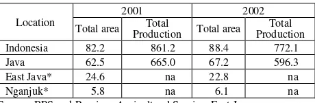
Assessment of Agricultural Production in Dry Season in Nganjuk District, East Java, Indonesia ... 345
Poster Paper Enhanced Access to the CGIAR Virtual Library via Social Media ... 351
Determining Suitable Area for Dairy Farm Using Model Builder ... 354
Identification of Potential Area for Paddy Field to Increase Rice Production Using Model Builder and Its Publication on The Internet: Case of Lombok Island, West Nusa Tenggara, Indonesia ... 357
The Model Builder for City Park Using ArcGis ... 362
Application HEC-HMS to Predict Hydrograph ... 372
So
Assessment of Agricultural Production in Dry Season in Nganjuk District, East
Java, Indonesia
Liyantono
United Graduate School of Agricultural Science Tokyo University of Agriculture and Technology
Tokyo, Japan e-mail: liyantono@ipb.ac.id
Tasuku KATO, Hisao KURODA, Koshi
YOSHIDA
regional sustainable development; however water shortage in dry season is problem in Nganjuk district. Therefore, groundwater is conjunctively used for irrigation with surface irrigation in the dry season. Objective of this paper is spatial assessment of agricultural production using GIS. GIS and remote sensing were used to analysis land use and irrigation wells density. Land use analysis was conducted to identify cultivated area in second dry season. Surface irrigation analysis conducted to get actual surface water supply in second dry season. The irrigation well density and utilization of groundwater for irrigation in second dry season was analyzed. The result shows land use was stable condition from 1999 until 2009 in second dry season. Agricultural production in Mrican-Kiri block was supported by water supply from surface irrigation. Agricultural production in other blocks was supported by conjunctive use of groundwater with surface irrigation, where Kuncir-Bodor block was enough water supply; Widas block was enough water supply but potentially water shortage was occur; and Ketandan-Tretes block was occurring of water shortage.Keywords: GIS, agricultural production, land use, irrigation well density
I. INTRODUCTION
Grain production in dry season is still important for regional sustainable development in Indonesia. Java is the main production area for grain in Indonesia, where 53 percent of paddy and 55 percent of corn from each total production are produced [5]. In the long term from environmental perspective, agriculture in Java must be conserved for sustainable food security in Indonesia. For that purpose, improvements in land use and water management are needed.
The Nganjuk District lies in a climatic regime characterized by the annual progress of rainy and dry seasons, and receives roughly 80% of precipitation within the 5 to 6 months of the rainy season (December-May). Nganjuk area has flat area in central and eastern of Nganjuk with altitude ranging from 35 to 100 m above sea level. Mountains area is located at southern and northern area.
The Brantas river basin has been one of the most productive and advanced granaries in Indonesia [10].
Nearly 84,000 ha within 387,100 ha on Brantas River basin is irrigated by the Brantas River while the rest is served from its tributaries [8]. There has been a dramatic transformation from low intensity agriculture to high intensity agriculture within the basin nowadays. Cropping intensity increased from around 0.8 in 1960 to 2.2 crops per year by 2000, while the area cultivated increased from 247,000 ha to the current 387,100 ha due to improvements in rice variety, increased agricultural inputs, and reliable water supply in the dry season [1].
Figure 1. Widas Basin
TABLEI. NDVI VALUE OF LANDSAT IN IRRIGATED AREA IN DS2
fields are cultivated in WS and DS1. Sugar cane cultivated in WS, DS1, and DS2. Secondary crops (corn, soybean, red onion, chilies, melons and vegetables) are cultivated in DS1 and DS2.
There are three main sub-basins in Nganjuk area, Widas, Kuncir, and Bodor sub-basins. Kedungsoko River is for Kuncir and Bodor basins, Widas River is for Widas sub-basin and those rivers were merged into Brantas River. In Nganjuk area, there are two main surface irrigation systems, Widas block and Mrican-Kiri block. The Widas block has irrigation command area in north western area of Nganjuk (around 8,832 ha). The Mrican-Kiri block has irrigation command area in south eastern area of Nganjuk (around 12,570 ha). In Widas block a reservoir is constructed in west of Nganjuk, and in Mrican-Kiri block, irrigation water is uptake from Brantas River (Mrican barrage). The surface irrigation system in Nganjuk area can supply irrigation water in DS1, however, it is not enough to supply water in DS2. Therefore, groundwater is used for conjunction irrigation with surface irrigation in the DS2.
An objectives of this paper is spatial assessment of agricultural production in second dry season. Especially, land use and irrigation wells density was analyzed by GIS to get spatial distribution.
II. METHODS
A. Land Use Analysis
The classification was concern to the irrigated area which was cultivated in DS2. NDVI analysis was conducted for LANDSAT series data from 1972 to 2009 in DS2.
B. Irrigation Wells Density Analysis
Irrigation well density (IWD) was generated from number of wells at agricultural field areas in each village. Criteria of IWD based on the radius influent of well in the research area. Radius influent of well in these research areas are varied at 118-348 m [6].
C. Irrigation Data
Irrigation intake was obtained from surface irrigation data in 2009. Average irrigation intake data was collected from four blocks in Nganjuk District. Water supply in DS2 (September 2009) was analyzed to confirm conjunctive use of groundwater.
D. Overlay Analysis
Overlay analysis was used to get the actual utilization of irrigation well in DS2. Irrigation well density (IWD) map was overlay with land use map to get the actual utilization of
irrigation well or pumps to support agricultural production in DS2.
III. RESULTS AND DISSCUSSIONS
A. Land Use
Vegetation NDVI typically ranges from 0.1 up to 0.7 [9], with higher index values associated with greater density and greenness of the plant canopy. Based on NDVI values, cultivated area in DS2 was increasing around 12% from 26.8% in 1972 to 38.8% in 1982. In the last decade, cultivated area was increasing around 30-40%, varied 71.0-86.3% area was cultivated. Widas, Ketandan-Tretes, and Kuncir-Bodor blocks were increased more than 10, 6, and 5 times, respectively. Mrican-Kiri block was increased around
1.6 times (Table 1 and Figure 2).
TABLEII. PERCENTAGE OF CULTIVATED AREA PER SEASON
Irrigation Block Widas Ketandan-Tretes
Source: RTTG 2006/2007, Nganjuk Irrigation service
Cultivated area was stable in WS and DS1 in whole irrigation blocks. 100% of irrigation blocks area was cultivated in WS and DS1 (Table 2). Paddy was predominant in WS (86-95% cultivated area). Paddy and secondary crop was predominant DS1, 38-69% and 28-58% cultivated area was paddy and secondary crop, respectively.
Land use was stable condition of land use change from 1999 until nowdays. Secondary crop was cultivated in almost cultivated area in DS2 (63-95% cultivated area). Paddy was cultivated 1-6% cultivated area in Widas and Kuncir-Bodor blocks. Sugar cane was cultivated 3-14% cultivated area in all irrigation blocks (Table 2).
Cropping intensity actual based on Central Bureau of Statistics of Nganjuk District 2007 and cropping intensity based on Global Annual Planting Plan (RTTG) 2006/2007 almost same is around 2.83 crops per year. Based on LANDSAT data 1999-2009, cropping intensity in DS2 is around 0.71-0.85 crop per season.
Agricultural production has same meaning with cropping intensity. The agricultural production was dramatically increased during 20 years. In 1991, average cropping intensity was 2.31 crops per years [3], and in the last 10 years was increased and stable at 2.8 crops per years.
Rice production was 414 metric ton per year with productivity around 5.8 ton per hectare and harvested area was 71,893 hectare. Corn production was 204 metric ton per year with productivity around 5.8 ton per hectare and harvested area was 35,144 hectare. Soybean production was 17 metric ton per year with productivity around 1.7 ton per hectare and harvested area was 10,091 hectare[4].
Nganjuk is one of central of vegetable crops, especially red onion. The production of that plant in 2008 was 86
metric ton. Total harvested area of red onions commodity in Nganjuk was around 6,000 ha per year or 25% of total East Java or 6% of total Indonesia (Table 3). Total harvested area of onions was 5% of total harvested area of Nganjuk District per year (113,192 ha). The percentage is not so high, but mostly onions commodity was cultivated at DS1 or DS2.
B. Irrigation Well Density Analysis
The number of well were varied from 0 to 606 wells per village and total number of well in Nganjuk is 15,475 wells. The IWD was varied 0-3 wells/ha. High exploitation (IWD >0.5 well/ha) has conducted in 79 villages. These villages are mostly located at Kuncir-Bodor block (Figure 3). Medium exploitation (0.05 < IWD 0.5 well/ha) has conducted in 120 villages and mostly located at Widas and Mrican-Kiri blocks. Low exploitation (IWD < 0.05 well/ha) has conducted in 47 villages.
The number of well in Kuncir-Bodor block was highest
(7,677 wells) and in Ketandan-Tretes block was lowest (346 wells) with average IWD 0.76 and 0.08 well/ha, respectively. The IWD has correlation with groundwater exploit, however, depend on the surface water supply in DS2.
Figure 2. NDVI of irrigation block area in DS2 in 1972, 1982, and 2009
TABLEIII. PRODUCTION OF ONION (IN METRIC HECTARE AND Source: BPS and Province Agricultural Service, East Java
TABLEIV. NUMBER OF WELL AND IWD PER IRRIGATION BLOCK
Irrigation Block Area (ha)
Based on data 2009, Mrican-Kiri, Widas, Kuncir-Bodor, and Ketandan-Tretes blocks was supply surface irrigation water around 7,390, 842, 300, and 0 l/s, respectively. Based on LANDSAT 2009, cultivated area in Mrican-Kiri, Widas, Kuncir-Bodor, and Ketandan-Tretes blocks was supplied irrigation water around 4.7, 1.1, 0.3, and 0 mm/d, respectively (Table 5).
Mrican-Kiri block was supply enough surface water in DS2. Widas block was supply little bit surface water and not enough for normally plant growth. Kuncir-Bodor was supply very small surface water and Ketandan-Tretes was not supply surface water in DS2.
TABLEV. SURFACE WATER SUPPLY IN SEPTEMBER 2009 PER IRRIGATION
D. Groundwater Utilization to Increase Agricultural
Production
The Widas River is one of the three major tributaries of the Brantas River and the large flatland lying between the Widas and the Brantas functioned as a retarding basin for years. Central and eastern of Nganjuk is located at the lowland of Solo Zone. The lowland in Solo Zone in Nganjuk area is alluvial plain formed by Widas River and Brantas River. Based on hydrogeology map [7], these area has good aquifer with medium and high productivity and has high specific capacity (>172.8 m2/d).
Water uses from groundwater until today not considered in the water resource planning. However almost farmer uses groundwater if the surface water (irrigation water) was insufficient in DS1 and DS2, that is groundwater is used for conjunctive irrigation with surface irrigation in the DS1 and DS2. The extraction of groundwater was using pumps. The irrigation well density (IWD) in Table 4 shows Kuncir-Bodor block had highest density (0.76 well/ha) and Ketandan-Tretes block had lowest density (0.08 well/ha). The IWD where related with water pumps was estimated by agricultural area and number of irrigation wells. However, IWD in Mrican-Kiri block was not related, because surface water was enough for a year. Irrigation wells in Mrican-Kiri
block is only used in occasional condition such as water allocation not well doing.
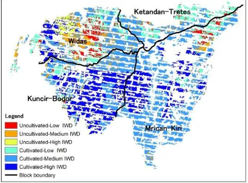
Based on overlay of IWD and land use in dry season, six class of farm area was classified (Figure 4). Cultivated and related with agricultural production in this block. However, IWD in Kuncir-Bodor block was related with agricultural
production because need more water supply from groundwater in DS2. Agricultural productivity in both blocks was almost same in WS, DS1, and DS2.
Water shortage was potentially occur in cultivated area with low IWD, especially in Ketandan-Tretes block caused no water supply in this area in DS2. 25% of Widas block was uncultivated and has IWD >0.05 well/ha. This area was already harvested in August and red onion was predominant. Agricultural productivity in DS2 in these blocks was lower than another blocks caused of water shortage.
IV. CONCLUSIONS
Land use and well density analysis is needed to get spatial evident in wide area to know actual cultivated area in DS2 within irrigation wells. Agricultural production in Mrican-Kiri block was supported by water supply from surface irrigation. Agricultural production in other blocks was supported by conjunctive use of groundwater with surface irrigation, where Kuncir-Bodor block was enough water supply; Widas block was enough water supply but potentially water shortage was occur; and Ketandan-Tretes block was occurring of water shortage.
REFERENCES
[1] Bhat, A., K. Ramu, and K. Kemper (2005) Institutional and Policy Analysis of River Basin Management, the Brantas River Basin, East Java, Indonesia. World Bank Policy Research Working Paper 3611 Figure 4. Overlay map of land use and irrigation well density (IWD)
[2] Bakorsurtanal (National Coordinating Agency for Survey and Mapping) (2001) Indonesia Earth Shape Map sheet 1508, Bogor [3] BPS of Nganjuk (1992) Nganjuk in Figures 1992. BPS of Nganjuk,
Nganjuk
[4] BPS of Nganjuk (2009) Nganjuk in Figures 2009. BPS of Nganjuk, Nganjuk
[5] BPS (Statistics Indonesia) (2009) Strategic Data of BPS. BPS, Jakarta [6] Prastowo, S. Hardjoamidjojo, B. Pramudya, K. Murtilaksono (2007) Performance of Shallow Groundwater Irrigation Schemes in Nganjuk-East Java, Indonesia. The CIGR Ejournal. Vol. IX. June. [7] Puspowardoyo, R.S. (1984) Indonesia Hydrogeology Map – Kediri
Sheet. Department od Mining and Energy. Bandung..
[8] Ramu, Kikkeri (2004) Brantas River Basin Case Study – Indonesia. Background Paper. World Bank, Washington DC, http://siteresources.worldbank.org/
INTSAREGTOPWATRES/Resources/Indonesia_BrantasBasinFINA L.pdf. Accessed 1 April 2009
[9] Roettger, S. (2007) NDVI-based Vegetation Rendering. In Proceeding of Computer Graphics and Imaging 2007, IASTED Press [10] Usman, Rusfandi (2001) Integrated Water Resource Management:
Lessons from Brantas River Basin in Indonesia. In Charles Abernathy (ed.), Intersectoral Management of River Basins: proceedings of an
international workshop on “Integrated Water Management in Water-Stressed River Basins in Developing Countries: Strategies for Poverty