Application of Integration of HBIM and VR Technology to 3D Immersive Digital
Management—Take Han Type Traditional Architecture as an Example
Yi-Chun Lin a
a Assistant researcher, College of Planning and Design, National Cheng Kung University, No.1, University Road, Tainan City 701,
Taiwan (R.O.C.) [email protected]
Commission VI, WG VI/4
KEY WORDS: HBIM, VR, immersive, Han type traditional architecture
ABSTRACT:
HBIM technology makes great contributions to 3D digital preservation and management of the existing traditional architectures, and VR technology has also been gradually emphasized by 3D users in recent years, especially 3D immersive situation makes users more likely to experience the real space field. Taking Han type traditional architecture with relatively complex geometrical structure as an example, this research carries out digital preservation through HBIM technology and tries to switch to VR platform to allow users to enter 3D immersive scene for management and display. It is shown in the research results that the application of integration of HBIM and VR technology to Han type traditional architecture needs to consider 3D digital model of the architecture, and the number of polygon shall be controlled below about 2 million, which can make the operation in VR environment more smooth; the integration of two technologies can achieve the purpose of 3D immersive digital management, which can provide the humanized application close to the real experience for the display of subsequent management of ancient relics and architectural aesthetics.
1. INTRODUCTION
Building information model (BIM) has been considered to be an important tool for architecture design, construction engineering and other related fields, which can produce critical and revolutionary change to the integration of industry; similarly, HBIM also has the same effect on the preservation and maintenance of historical architecture, and has made great contributions [1], [2]. Although it has been gradually mature to apply HBIM technology to digital management of historic relics, it is not widely used by relevant government units. Take Taiwan as an example, it is still in the observation and research stage, in addition to HBIM standardized operating procedures not formulated, the integration of existing 3D digital results is also one of the problems. With the progress of science and technology, new technologies are brought forth one by one and VR is a technology of modeling 3D virtual scene, which is widely used in the establishment of software for early games, and experience 3D scene changes through the touch of computer screen [3]. The research and development of VR wearable hardware allows users to place themselves in 3D digital scene and make interactive experience with virtual digital contents [4]. Such development makes BIM users research and integrate the feasibility of BIM and VR, and specific interface information is provided to the conversion between the data format of BIM and the data format of VR, so important achievements are obtained [5].
HBIM is applied to existing construction plan, therefore, it conforms to the digital management and applications of traditional architecture, architecture 3D digital is different from the scene of game software, which has the specifications for the precision of space size, and accurate and complete recording of the existing architecture size, appearance and size is the demand necessary for the subsequent application. The use of 3D laser scanning technology for3D digital operation on the existing architecture has become the common technology used for the digital libraries of traditional architecture [6], 3D point cloud
model composed of 3D spatial coordinates with high precision and high density becomes the reference basis for the mapping of follow-up elevation, profile and vertical plan, and the information source of relative size and appearance during 3D model establishment operations, so the application of 3D laser scanning technology has become an important tool for the establishment of HBIM space information. The completed HBIM results can also exert digital management function to provide sustainable information platform for the storage, maintenance, display and education of traditional architecture, which is just like BIM. The wearable VR technology has the effect of 3D immersive experience, and it is expected to promote the effect of preservation, maintenance, display and education of traditional architecture after it is integrated with HBIM information platform. Users will be placed and close to real 3D space scene for more effective digital management; observe architectural form and structure from different angles and experience the essence of traditional architecture process; meanwhile, Internet provides more convenient way to experience to global interested users.
2. RESEARCH CONTENTS
This study takes Han type traditional architecture with complex geometric structure as an example to conduct 3D scanning digital operation on the research subject, and information platform of HBIM is established and subsequently relevant information presented by HBIM in VR environment are integrated.
2.1 Selection of Research Subjects
The selected research subjects are Han type architecture, including parts of architecture of Tainan Confucius Temple in Taiwan and Qiu Lian-gung's Mother Chastity Arch in Kinmen, these two traditional architectures are historic sites at state level Taiwan declares, its historicality and artistic quality are of highly cultural value (Fig. 1 and Fig. 2), and meanwhile they are Han type traditional architecture of different types, and the differences
The International Archives of the Photogrammetry, Remote Sensing and Spatial Information Sciences, Volume XLII-2/W5, 2017 26th International CIPA Symposium 2017, 28 August–01 September 2017, Ottawa, Canada
This contribution has been peer-reviewed.
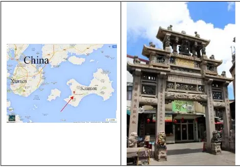
can be analyzed in the research process. Among them, Tainan Confucian Temple was built by Chen, Yong-hua in Yongli 19th year of Ming Dynasty (1665). The architecture makes the temple which is used to sacrificed Confucius as the main body, beside it is Minglun Room set for the opening of school, invitation of teachers, lifting the virtuous person and selection of talents; it not only becomes the earliest Confucius temple established in Taiwan, but opens up Taiwan's Confucianism, known as "The First Scholarship in Taiwan". Qiu Lian-gung's Mother Chastity Arch in Kinmen is to praise Mrs. Xu in Jinmen, who nursed his son alone and kept to chastity and finally taught his son to be famous, it was established in Jiaqing 17th year (1812) and the most magnificent pattern of stone archway of Qing Dynasty. Among the stone archways in Taiwan and Fujian areas, the dimension of Qiu Lian-gung's Mother Chastity Arch is the largest [7].
Fig. 1. Geological Location of Tainan Confucian Temple (the left, selected from Google Map), Photo (the right)
Fig. 2. Geological Location of Qiu Lian-gung's Mother Chastity Arch in Kinmen (the left, selected from Google Map), Photo
(the right)
2.2 Establishment of 3D Point Cloud Model
Of the above two research objects in 3D laser scanner, 3D digital operation, this research uses FARO Focus equipment for 3D models of collocation FARO scene 3D point cloud processing software level after the point cloud data processing, the two eventually are complete and high precision of 3D point cloud model.
2.3 Establishment of HBIM
As BIM has the function of respectively establishing space information and attribute information of the design objects, in terms of two research subjects in this research, the architectural space structure and characteristics of two traditional architectures must be classified first, then the corresponding attribute data should be arranged and collected so as to facilitate the establishment of spatial database and attribute database of HBIM. The program of such establishment is used for the convenience of management and maintenance in future. Taking this research as an example, Autodesk Revit is adopted as the establishment platform of HBIM, and the procedures relevant establishment follows up are as follows:
1. Analyze and classify architecture structures and characteristics.
2. Arrangement form of attribute data corresponding after the classification.
3. Read 3D point cloud model.
4. Capture point cloud according to the classification and establishment of 3D model.
5. establishment of attribute data of 3D model according to classification form of attribute data.
6. carry out a functional test after the completion of establishment of all the projects.
2.4 Establishment of VR
Exclusive design software (such as Unity) is often matched with establishment of VR, and is often used in game software or the production of type guide products. Due to the rapid development of the integration of software and hardware (such as Oculus, hTC, Google), VR is seen as the most important industry after the invention of mobile phone. For the demand in the engineering field (such as architecture and civil engineering), precise space dimension and attribute record become important, as they need to examine the defects of related design; for the demand in the field of education, interaction becomes more important in order to make students experience the learning effects brought about by learning objectives in virtual environment. Taking Hay type traditional architecture as an example, this research expects to focus on the accuracy and integrity of architecture on VR platform in combination with the display of complete attribute data, making the data established in HBIM presented in VR environment, and making users stand in 3D virtual scene to think about and detect contents of materials from different angles instead of discussing and analyzing on the screen, which will help to the subsequent maintenance and management of historical architecture. At the same time, if additional values can be given to the task of education and culture transmission, you can experience the beauty of traditional construction technology and cultural connotation in real 3D environment, which is the most important concept of HBIM established with traditional architecture as an example in combination with VR.
This research tries to make commercial software of Fuzor VR [8] as the platform, as Fuzor and Autodesk Revit use "Live Link” for data transmission and link, for example, click on "Edit selection" function key in Fuzor Plugin, “Live Link" of Fuzor will search for the plan corresponding to Autodesk Revit; the use of material editor of Fuzor can directly change material in Fuzor and transmit real-time change information to material database corresponding to Autodesk Revit, the characteristic of compatibility in both provides a convenient way to the implementation of this research. But for structure and morphology of Han type traditional architecture with many curved surfaces, in terms of how
The International Archives of the Photogrammetry, Remote Sensing and Spatial Information Sciences, Volume XLII-2/W5, 2017 26th International CIPA Symposium 2017, 28 August–01 September 2017, Ottawa, Canada
This contribution has been peer-reviewed.
Autodesk Revit is effectively transposed to VR platform, polygon faces on the surface of model need to be controlled on 3D model establishment end.
3. MAIN BODY OF TEXT
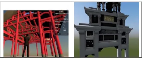
The achievements produced in the research process are preliminarily 3D point cloud model (Fig. 3) of two Han type traditional architectures established with the use of 3D laser scanner, such model is through rigorous scanning operation procedures, with the average accuracy of the obtained 3D point cloud model of mm grade, and application for 3D laser scanner, the establishment of two Chinese type of traditional architecture (Fig. 4) 3D point cloud model, this model through, obtained the average accuracy of mm level 3D point cloud model, 3D digital modeling assignment of HBIM will be provided subsequently. After importing 3D point cloud model of two Han type traditional architectures through Autodesk Revit, classification is made based on the architecture structure of two Han type traditional architectures (temple and honorific arch), the information of 3D point cloud models after the classification is captured to establish space information and attribute information, and the related establishment achievements are shown Figure 4. Subsequently, the data contents of HBIM will be transposed to Fuzor VR Platform (Fig. 5), on the upper right part of Figure 5 is attribute data table, and interactive attribute query can be made in VR environment, but the fluency and integrity of the operation of transposed data in Fuzor VR environment need to be tested.
Fig. 3. 3D Point Cloud Model (the left: Tainan Confucian Temple, the right: Qiu Lian-gung's Mother Chastity Arch in
Kinmen)
Fig. 4. Autodesk Revit Establishment Results (the left: Tainan Confucian Temple, the right: Qiu Lian-gung's Mother Chastity
Arch in Kinmen)
Fig. 5. VR Results of Fuzor Platform Establishment (the left: Tainan Confucian Temple, the right: Qiu Lian-gung's Mother
Chastity Arch in Kinmen)
4. CONCLUSION
Han type traditional architecture has relatively complex geometric structure, so rigorous 3D laser scanning operation must be conducted in the establishment process of HBIM, and for the area which has historical but cannot be scanned due to the shelter, other tools or technologies (such as handheld scanner, technology of Structure from Motion) can be used to capture the data of such area so as to improve the integrity of HBIM establishment and VR application.
Autodesk Revit platform is one of software widely used for establishment of HBIM, general VR platform tries to provide the functions compatible to Autodesk Revit to ensure the application of BIM in VR, such as the Unity [9] and COVISE [5], the transposition of Autodesk Revit to Unity must be through the assistance of 3DMAX. Fuzor is VR software published at present which has better linkage with Autodesk Revit, but faces of polygon still need to be controlled for the 3D digital model in case of too many faces leading to uncertainty of transposition, and the experience value of face control in this research is below 2 million, and it is certain that such kinds of problems can be solved when the future computing performance is stronger.
Integration of HBIM and VR can really improve the maintenance of traditional architecture with historical value, the management and display of the beauty of architecture process, which has the great significance for substantial improvement of management quality, education training and cultural heritage. If the conflict analysis scene of discussing architecture planning and design in front of the computer screen is transferred to 3D virtual VR environment, rapid solution to problems and reaching a consensus should be the most basic and shocking experience HBIM+VR gives.
ACKNOWLEDGEMENTS (OPTIONAL)
This research was supported by the Taiwan Ministry of Science and Technology “Historic Building Information Modeling (HBIM) for Value-Added Application of Aesthetic Experience of Historic Building” (Project No. 104-2420-H-006-021-)
REFERENCES
1. Murphy M, McGovern E & Pavia, S 2011, 'Historic Building Information Modeling – Adding Intelligence to Laser and Image Based Surveys', paper presented to 4th ISPRS International Workshop, 3DARCH 2011: "3D Virtual Reconstruction and Visualization of Complex Architectures" Trento, Italy, 2-4 March 2011, pp.89-102.
The International Archives of the Photogrammetry, Remote Sensing and Spatial Information Sciences, Volume XLII-2/W5, 2017 26th International CIPA Symposium 2017, 28 August–01 September 2017, Ottawa, Canada
This contribution has been peer-reviewed.
2. Dore, C., Murphy, M., 2012, “Integration of Historic Building Information Modeling and 3DGIS for Recording and Managing Cultural Heritage Sites”, 18th International Conference on Virtual Systems and Multimedia: "Virtual Systems in the Information Society", 2-5 September, 2012, Milan, Italy, pp.369-376.
3. Jack Steven Goulding, 2014, “Virtual Reality-Based Cloud BIM Platform for Integrated AEC Projects”, Journal of Information Technology in Construction, September 2014 4. Mikael Johansson, Mattias Roupé, Mikael Viklund Tallgren,
2014, ”Integrating immersive visualizations in the current design process”, eCAADe 32, Newcastle, United Kingdom, pp.261-269.
5. Joachim Kieferle, Uwe Woessner, 2015, “A Bidirectional Interaction Method for BIM Models in Different Environments”, eCAADe 33, Vienna, Austria, pp.69-75. 6. Yi-Chun Lin , Tsung-Chiang Wu, Min-Fu Hsu, 2013, “3D
Digital Simulation of Minnan Temple Architecture Caisson’s Craft Techniques”, International Archives of the Photogrammetry, Remote Sensing and Spatial Information Sciences, Volume XL-5/W2, 2013, pp.403-408.
7. Bureau of Cultural Heritage, MOC, TAIWAN website, http://www.boch.gov.tw/
8. Fuzor website, https://kalloctech.com/
9. Ben Dalton, Maxwell Parfitt, 2013, “Immersive Visualization of Building Information Models”, Design Innovation Research Centre Working Paper, Number 6, University of Reading, UK.
The International Archives of the Photogrammetry, Remote Sensing and Spatial Information Sciences, Volume XLII-2/W5, 2017 26th International CIPA Symposium 2017, 28 August–01 September 2017, Ottawa, Canada
This contribution has been peer-reviewed.