Open Geospatial Consortium
Publication Date: 2014-11-12
Approval Date: 2014-09-19
Posted Date: 2014-08-25
Reference number of this document: OGC 14-086r1
Reference URL for this document: http://www.opengis.net/doc/PER/AAtSH_Summary
Category: Public Engineering Report
Editors: Josh Lieberman, Johannes Echterhoff, Matt de Ris, George Wilber
OGC
®Aircraft Access to SWIM (AAtS) Harmonization
Architecture Report
Copyright © 2014 Open Geospatial Consortium
To obtain additional rights of use, visit http://www.opengeospatial.org/legal/.
Warning
This document is not an OGC Standard. This document is an OGC Public
Engineering Report created as a deliverable in an OGC Interoperability Initiative and is not an official position of the OGC membership. It is distributed for review and comment. It is subject to change without notice and may not be referred to as an OGC Standard. Further, any OGC Engineering Report should not be referenced as required or mandatory technology in procurements.
Document type: OGC® Engineering Report Document subtype: NA
OGC 14-086r1
ii Copyright © 2014 Open Geospatial Consortium
Preface
The FAA’s Aircraft Access to System Wide Information Management (AAtS) initiative is in its evolutionary stages of requirements and standards development. Its goal is to provide aircraft connectivity to the FAA’s System Wide Information Manager (SWIM) infrastructure to communicate/share aviation data and services. This connectivity will establish a common operating picture between the flight deck and air traffic control for collaborative strategic decision-making. Distribution of the vast amount of operational information, such as aviation information (AI), meteorological (MET) and air traffic management (ATM), needed to support the safe movement of aircraft during all phases of flight in the National Airspace System (NAS) will increase capacity, efficiency, and result in more timely departures and arrivals.
Similarly, there are a number of aviation standards in development by a variety of industry groups and committees (i.e., the RTCA Special Committee 206 (SC-206), ARINC 830 Aircraft/Ground Information Exchange (AGIE), and Open Geospatial Consortium (OGC) standards) that are also pursuing the development of requirements and standards to leverage ground based aviation related information and data networking technology to support the operation of aircraft.
FAA and the aviation industry are moving towards consensus that electronic distribution of operational data and technical information will increase the NAS/airline productivity and efficiency and deliver a more positive passenger experience both domestically and internationally. However, there is a need to encourage harmonization of all of these efforts since the aforementioned aviation committees also represent global interests. The AAtS Harmonization project has carried out a number of activities with the goals of
Identifying and analyzing differences in requirements/standards undertaken by SC-206, AGIE, and OGC;
Analyzing draft standards and recommending changes during SC-206 and AGIE standards development to improve harmonization prospects
OGC 14-086r1
Copyright © 2014 Open Geospatial Consortium iii
Executive Summary
Background
The FAA’s Systems Engineering, NAS Architecture organization sponsored an effort to harmonize industry standards with the Open Geospatial Consortium (OGC) as the lead. The effort was organized with a small core team responsible for developing strategy and products, and a larger industry wide team providing inputs, cross-industry perspectives and expertise in the industry standard efforts. Core team members were: FAA AAtS, OGC, Boeing, Panasonic, and North Star. Other key contributors were members of the AAtS Harmonization tiger team (see Annex A).
Tasks and Accomplishments
Project work focused on harmonizing AAtS with RTCA SC-206 (architecture and requirements), ARINC 830 Air Ground Information Exchange (AGIE) and OGC standards. Initial harmonization tasks included:
1. Analyzing existing standards;
2. Analyzing and shaping emerging standards;
3. Developing a harmonized architecture that addresses the functional requirements; 4. Formulating conclusions and recommendations to:
a. update existing standards in order to address identified harmonization issues
b. support decision processes of policy makers, government, and industry. One of the major challenges of AAtS Harmonization revolves around emergent and existing standards from multiple organizations with differing priorities. These
organizations naturally develop standards to address technical and operational priorities for their own stakeholder needs and from their own perspective. Project participants analyzed the purpose, scope, and overlap space of each standard or package of standards specifically from the perspective of the AAtS concept, giving special attention to
standards representing conflicted priorities, interfaces, or operational services.
The harmonized architecture defines areas of overlaps and gaps defined by the standards intended uses, end user applications and key business requirements. The architecture defines interface areas and provides a view of a layered architecture that shows where the different applications, services and middleware functions interact and where out-of-scope but adjacent critical functions fit. In this layered view, AAtS and SC-206 standards provide both unique application-specific functionality and reusable middleware-services infrastructure. In the context of AAtS, use of AGIE and OGC standards falls mainly into the reusable infrastructure layer
The architecture is also described in a system level view with nominal component
OGC 14-086r1
iv Copyright © 2014 Open Geospatial Consortium
infrastructure and AGIE’s client-server features. The architecture describes key functional features that are common across the standards and where they might be allocated to provide an efficient and harmonized implementation. Key common requirements as well as conflicting ones are also identified.
Successful harmonization was achieved not only by architectural innovation, but also by the team’s efforts to influence the course of standards themselves during the project. Due to these efforts, the SC-206 and AAtS architectures are now more compatible and the AGIE standard is more compatible with both AAtS and SC-206.
Harmonization Impacts
This effort made critical impacts on several industry activities:
1. The ARINC 830 (AGIE) standard was modified to build in air traffic management functionality and meet ATM requirements.
2. The AAtS architecture was mapped directly to the RTCA SC-206 architecture and the AAtS Implementation Guidance Document (IGD) updated accordingly in v3.0 (harmonization phase 1).
3. The RTCA DO-349 recommendations standard was edited to be more inclusive of larger industry concepts
4. Further, inputs and recommendations to the AAtS IGD will bring IGD v4.0 more in line with global industry needs and objectives (harmonization phase 2).
5. The harmonized architecture defined by industry efforts in this project will impact how SC-206, AGIE and OGC concepts and requirements fit in the AAtS
architecture and business proposition in upcoming development efforts.
6. The AAtS prototype/demonstration document provides an outline and blueprint for building a proof-of-concept framework to show how AAtS can function in an integrated airline-defined solution.
Conclusions and Recommendations
The goal of the project to “harmonize standards and concepts within the AAtS trade space” was accomplished through outreach to and coordination in project activities amongst multiple standards team members from representative industry stakeholders. Project activities led to the following conclusions and recommendations in addition to those specific to the harmonized architecture that are presented in OGC document 14-073.
Project Conclusions
1. There is a missed opportunity to realize the full value of AAtS and the capabilities of services based off of NAS service / SWIM sourcing.
2. The value proposition for industry to implement AAtS is lacking.
OGC 14-086r1
Copyright © 2014 Open Geospatial Consortium v
information exchange elsewhere in the world. Global interoperability and therefore a global market is far from a given.
4. A harmonized architecture based on AAtS with SC-206, AGIE and OGC
standards is achievable and provides a framework for deploying AAtS in a multi-domain solution.
5. Harmonization across these three standards in the AAtS architecture allows the benefits of the capabilities from each standard to be realized in a consistent implementation.
6. The AAtS architecture as defined in IGD v3.0 is too constraining to fully reflect the capabilities and benefits of the harmonized architecture.
Project Recommendations
1. Recommend incorporation into future updates of the AAtS IGD of an enhanced and broader architecture and environment based on the harmonization team review comments and recommendations.
2. Recommend the development and testing of a harmonized solution (prototype). 3. Recommend follow-on harmonization efforts to include other key industry
standards.
4. Recommend follow on harmonization efforts to define global interoperability and interaction with other global efforts
5. Recommend that the FAA develop an FAA-wide implementation plan to integrate AAtS to other elements within the NAS to bring near term value to aircraft
OGC 14-086r1
vi Copyright © 2014 Open Geospatial Consortium
Contents
Page1 Introduction ...1
1.1 Purpose & Objective ...1
1.2 Scope ...1
1.3 Document contributor contact points ...2
1.4 Revision history ...2
1.5 Future work ...2
1.6 Foreword ...3
2 References ...3
3 Summary and chronology of Activities and Products ...3
4 Request for Information and Community Workshop ...4
5 Standards Harmonization Outreach ...6
6 Prototype Outline ...7
7 Harmonized Architecture ...7
8 ICAO Working Paper ...8
9 Conclusions and Recommendations ...8
Annex A: Participants ...11
OGC 14-086r1
Copyright © 2014 Open Geospatial Consortium vii
Figures
PageFigure 1. OWS-9 Aviation Architecture, including prototype Data Management Service
(DMS) 6
Figure 3 – FAA/NAS AAtS Architecture in Global or International Context (from OGC
OGC® Public Engineering Report OGC 14-086r1
Copyright © 2014 Open Geospatial Consortium 1
OGC® Aircraft Access to SWIM (AAtS) Harmonization
Architecture Report
1 Introduction
1.1 Purpose & Objective
The Federal Aviation Administration (FAA) and industry are moving toward consensus that electronic distribution of operational data and technical information will improve shared situational awareness (SSA), increase National Airspace System (NAS) efficiency and deliver a more positive passenger experience both domestically and internationally. With that comes the need to identify harmonization opportunities across multiple
standardization efforts. The purpose of the AAtS Harmonization activity has been to leverage the strengths of distinct but related standardization efforts in order to improve the scope, scale, and interoperability of aircraft-ground data communications under the auspices of the FAA AAtS concept and program.
The objective of this document is to summarize the range of events and products that have characterized the harmonization effort beyond the development of the harmonized architecture itself.
1.2 Scope
This OGC® document summarizes the Aircraft Access to SWIM (AAtS) Harmonization activity developed by a team funded by the FAA and led by the Open Geospatial
Consortium (OGC). The activity involved assembling a core team of industry participant experts to analyze and harmonize four standards suites and/or standards-based
architectures relevant to air-ground information exchange: The Aircraft Access to SWIM (AAtS) concept,
RTCA aeronautical information services (AIS) and meteorological (MET) information data link service committee’s (SC-206) concepts and standards, Air-Ground Information Exchange A830 (AGIE) standard and
OGC standards and architectural perspectives. Elements of this effort have included:
Creation and public release of a Request for Information
Analysis of the fits and overlaps between the four standards suites Engagement with ongoing standards development efforts to reduce
OGC 14-086r1
2 Copyright © 2014 Open Geospatial Consortium
Creation of a broader industry “Tiger team” to review and provide feedback on activities and outcomes
Development of a harmonized system architecture
Creation and delivery of documentation for a harmonized AAtS prototype Creation of a working paper and presentation for submission to ICAO
1.3 Document contributor contact points
All questions regarding this document should be directed to the editor or the contributors:
Name Organization
George Percivall Open Geospatial Consortium Johannes Echterhoff interactive instruments GmbH Joshua Lieberman Tumbling Walls
Matt de Ris Panasonic Avionics Corporation Rick Wilber Boeing
1.4 Revision history
Date Release Editor Primary clauses
All First complete draft from material previously in architecture report
August 25, 2014
0.5 Joshua Lieberman
All Response and update following August F2F meeting
September 3, 2014
0.6 Joshua Lieberman
Various Editorial updates
1.5 Future work
In the course of carrying out the AAtS Harmonization activity, a number of opportunities for valuable follow-on activities were identified:
Testing and validation of the recommended AAtS architecture through one or more prototyping activities;
Extension of harmonization down into lower architectural layers (transport, data link);
International outreach and harmonization with other SWIM and AAtS systems that are being designed and developed;
Development of business value propositions for additional stakeholders (for example, value for aircraft operators);
OGC 14-086r1
Copyright © 2014 Open Geospatial Consortium 3
Development and testing of additional OGC standards and standard profiles relating specifically to aviation and AAtS, such as a Data Management Services (DMS) specification.
Continued outreach via the harmonization tiger team to ensure industry participation in AAtS evolution, such as defining inputs to future versions of AAtS IGD, presentation and message-to-industry activities (RTCA, AEEC executive committee (SAI), and other relevant activities.
1.6 Foreword
Attention is drawn to the possibility that some of the elements of this document may be the subject of patent rights. The Open Geospatial Consortium shall not be held
responsible for identifying any or all such patent rights.
Recipients of this document are requested to submit, with their comments, notification of any relevant patent claims or other intellectual property rights of which they may be aware that might be infringed by any implementation of the standard set forth in this document, and to provide supporting documentation.
2 References
The following documents are referenced in this document. For dated references, subsequent amendments to, or revisions of, any of these publications do not apply. For undated references, the latest edition of the normative document referred to applies.
ARINC 830 Air/Ground Information Exchange (AGIE)
FAA Aircraft Access to SWIM (AAtS) Implementation Guidance Document (IGD) v3.0
FAA Aircraft Access to SWIM (AAtS) Concept of Operations (ConOps) v1.0 RTCA DO-340 Concept of Use for Aeronautical Information Services (AIS) and
Meteorological (MET) Data Link Services
RTCA DO-349 Architecture Recommendations for Aeronautical Information (AI) and Meteorological (MET) Data Link Services
OGC Document 14-073 AAtS Harmonization Architecture Report
3 Summary and chronology of Activities and Products
The OGC AAtS Harmonization project conducted these major events and activities: 2013-07-01: Project Start
OGC 14-086r1
4 Copyright © 2014 Open Geospatial Consortium
2013-12-17/18: Community Workshop, Washington (Tiger Team meeting #1) 2013-12-25: First draft of AAtS Harmonization Report
2014-01-09: Workshop feedback (on Survey Monkey) 2014-03-14: First draft of Prototype Architecture 2014-04-10/11: Tiger Team meeting #2
2014-04-22: First Draft of ICAO White Paper
2014-05-19: Prototype architecture and ROM transmitted to FAA 2014-07-30/31: Tiger Team meeting #3
2014-08-29: All project deliverables complete
The project produced these major deliverables that were transmitted to FAA and / or released publicly:
“Request for Information (RFI) for Guidance on AAtS Standards Harmonization,” RFI Issuance Date: 23 September 2013
“AAtS Prototype Outline” delivered 19 May 2014.
“AAtS Harmonization Architecture Report” – OGC document 14-073 “AAtS Harmonization Project Summary – this document
“AAtS Harmonization ICAO Working Paper,” to be published by 30 September 2014.
Presentation materials for the events listed above were also produced and distributed to team members and participating organizations.
4 Request for Information and Community Workshop
A Request for Information (RFI) was released by OGC on 23 September 2013 and was intended to engage the community in identifying standards efforts relevant to the provision of aircraft connectivity to the FAA’s SWIM infrastructure to
communicate/share aviation data and services, as planned in the FAA’s Aircraft Access to System Wide Information Management (AAtS) initiative.
The RFI was supported by the following organizations in addition to OGC:
The FAA’sAircraft Access to System Wide Information Management (AAtS)
OGC 14-086r1
Copyright © 2014 Open Geospatial Consortium 5
The ARINC AGIE/MAGIC subcommittee (http://www.aviation-ia.com/aeec/)leads
ARINC Project Paper 830 - Aircraft/Ground Information Exchange, establishing a standard for a non-proprietary application level information interchange framework. This includes protocols, functions, and interfaces that enable application-to-application
information exchange between aircraft and ground applications in a universal manner. Organizations responding to this RFI contributed information on:
- Technologies, standards and general trends relevant to AAtS
- Practical recommendations on harmonization opportunities and challenges - Insights on how to best craft an interim path for the community and to develop a
technical architecture that is forward thinking and can accommodate this emerging and evolving environment.
- Global harmonization considerations
Responses were received from WMO, Honeywell, and Harris Corporation. Information provided in the RFI responses guided the discussion at a community workshop held 17-18 December 2013 in Washington DC. The workshop also built on aviation information exchange work done in OGC Web Services (OWS) Testbeds 9 and 10.
Workshop discussion topics included:
Use cases and intended uses for AAtS
Information flow between and within air and ground systems Key AAtS requirements
OGC 14-086r1
6 Copyright © 2014 Open Geospatial Consortium
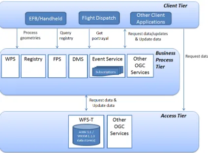
Figure 1. OWS-9 Aviation Architecture, including prototype Data Management Service (DMS)
5 Standards Harmonization Outreach
Members of the AAtS Harmonization activity core team engaged with the following standards development groups in order to improve the prospects for harmonization of the various standards suites:
ARINC 830 (AGIE) was materially altered to include concepts that allowed alignment with the architecture being put together by RTCA SC206.
OGC 14-086r1
Copyright © 2014 Open Geospatial Consortium 7
6 Prototype Outline and Plan
The AAtS Harmonization team delivered to FAA a prototype outline and comprehensive plan describing a harmonized AAtS system prototype and demonstration. The document provides prototype and demonstration objectives, along with purpose and approach. It contains detailed descriptions of topology, components, demonstration scenarios and scripts, along with conceptual data definitions and operator interactions.
7 Harmonized Architecture
The AAtS Harmonization team produced an engineering report on the developed harmonized architectures (OGC document 14-073). This report focuses on the
harmonization of AAtS as described in FAA IGD v3.0 with RTCA SC-206 (architecture and requirements), ARINC 830 Air Ground Information Exchange (AGIE) and OGC standards. Harmonization tasks included:
1. Analyzing and shaping existing as well as emerging standards;
2. Developing a harmonized architecture that addresses the functional requirements; and
3. Formulating conclusions and recommendations to: a. address identified harmonization issues
b. support decision processes of policy makers, government, and industry This report documents:
a harmonized architecture based upon concepts and standards from FAA AAtS, RTCA SC-206, ARINC 830 (AGIE) and OGC
OGC 14-086r1
8 Copyright © 2014 Open Geospatial Consortium
Figure 2 – FAA/NAS AAtS Architecture in Global or International Context (from OGC 14-073)
8 ICAO Working Paper
The AAtS Harmonization team has continued its outreach activities by distilling the results and recommendations of the project into a working paper for submission to ICAO, together with materials for a presentation to ICAO by FAA. The working paper proposes that a unified ICAO SWIM-aircraft connectivity position be developed based on the concepts and architecture developed in the AAtS Harmonization activity before the various solutions currently in development drift further far apart in their ability to efficiently interoperate.
9 Conclusions and Recommendations
The goal of the project to “harmonize standards and concepts within the AAtS trade space” was accomplished through outreach to and coordination in project activities amongst multiple standards team members from representative industry stakeholders. Project activities led to the following conclusions and recommendations in addition to those specific to the harmonized architecture that are presented in OGC document 14-073.
Project Conclusions1
1. There is a missed opportunity to realize the full value of AAtS and the capabilities of services based off of NAS service/SWIM sourcing. As envisioned and
supported by RTCA standards the AAtS architecture can support a range of criticalities. There is a perception within the FAA that if information is sourced from SWIM or it does not build or contract for the delivery system, then the end-to-end system should not support higher critical uses. This perception is
contradicted by existing commercial systems that can support safety critical functionality (e.g., RCP240/RSP180 oceanic and remote CPDLC and ADS-C). Additionally, both AGIE and SC-206 contain capabilities that can directly or indirectly support air traffic services (ATS) and communicate with the ACD. 2. The value proposition for AAtS to the industry is lacking – Lack of information
about services, lack of services with operational value, insufficient benefit definition of why SWIM based information services versus traditional sourcing makes the question of “why AAtS?” difficult to answer. There is an identified opportunity to make aircraft operators and general aircraft operations more efficient which cannot be realized without AAtS integration into the NAS systems.
3. Uncertainty and inherent industry risk exists for implementing AAtS due to lack of global interoperability –Any commercial entity that intends to put AAtS into
OGC 14-086r1
Copyright © 2014 Open Geospatial Consortium 9
practice will limit the number of technology stacks that must be implemented while maximizing its customer base and customer offering. There are other similar global efforts underway to define the SWIM connectivity options to aircraft. It is, currently, not at all certain that these other concepts will be
interoperable with the FAA’s plan. This inherent risk, both technological as well as monetary, induces hesitancy in would-be AAtS implementers.
4. A harmonized architecture based on AAtS with SC-206, AGIE and OGC
standards is achievable and provides a framework for deploying AAtS in a multi-domain solution.
5. Harmonization across these three standards in the AAtS architecture allows the features of each standard to be implemented together in a consistent system. 6. The AAtS architecture as defined in IGD v3.0 is too constraining and needs to be
updated and expanded in v4.0.
Project Recommendations2
1. Recommend revision of the AAtS IGD v3.0 based on the team review comments and recommendations as well as the recommended system architecture presented in the architecture report. As discussed previously, the team has performed a detailed industry-based review of the guidance found in the AAtS IGD v3.0. Updated implementation guidance will provide value to all stakeholders involved in deploying an AAtS solution. The industry representatives within the team recommend the adoption and incorporation of team input that includes the following concepts:
Non-SWIM data sourcing inclusion in the architecture of AAtS A role for safety critical applications within the AAtS trade space
Updates to the AAtS architecture to facilitate more recognizable industry business value and more achievable global interoperability
2. Recommend development and testing of a prototype implementation of the harmonized architecture – a prototype is necessary to show industry value as well as technical readiness in a harmonized AAtS solution that leverages industry standards as well as to spur industry adoption. Prototyping efforts often lead to industry practices that motivate additional standards development.
3. Recommend follow-on harmonization work covering additional industry standards – while the work performed under this effort was worthwhile and has resulted in significant progress towards achieving interoperable solutions, it cannot be considered complete or comprehensive across the industry or even the complete AAtS architecture. Within the constraints of a realistic budget, it is recommended that further work investigate harmonization issues with ARINC 841 MIAM, ARINC 839 MAGIC, selected EFB standards, and others as recommended by the RFI workshop and Tiger Team participants.
OGC 14-086r1
10 Copyright © 2014 Open Geospatial Consortium
4. Recommend follow-on harmonization with other global efforts – the FAA’s AAtS is the closest to implementation and as such should continue to embrace
international leadership of the SWIM to aircraft concept paradigm. The differences between the potential approaches of other state aviation agencies indicate that on a long enough timeline, it is likely that the FAA’s current
concepts may need to change or risk becoming non-interoperable. Harmonization includes: applications, intended uses, requirements, time lines, architectures, standards, and business models.
5. Recommend FAA-developed FAA-wide implementation plan to integrate AAtS to other elements within the NAS to bring near term values to aircraft operators. This includes such items as:
a. Align NAS Program Concept of Operations with AAtS Concept of Operations
b. Integrating AAtS into the next NextGen Segment Implementation Plan (NSIP) Operational Improvements (OIs) based off of the uses described in the AAtS Concept of Operations. Details include:
i. schedule
ii. adequate funding iii. necessary capabilities
c. Identifying the specific NAS programs that will leverage AAtS capabilities and integrating AAtS into their implementation plans
OGC 14-086r1
Copyright © 2014 Open Geospatial Consortium 11
Annex A: Participants
Name Organization Role
Allan Hart Honeywell TIGER Team
Art Ahrens Harris Corporation Workshop Participant
Dee Llewellyn Lockheed Martin Workshop Participant
Ezra Jalleta MITRE Workshop Participant
Farid Aknine North Star Group, LLC Core Team
George Percivall Open Geospatial Consortium, Inc. Core Team
George Wilber Boeing Core Team
Johannes Echterhoff interactive instruments GmbH Core Team
John Moore Jeppesen/Boeing TIGER Team
John Pace North Star Group, LLC Core Team
Joshua Lieberman Lieberman, Joshua Core Team
Ken Gochenour Jeppesen/Boeing TIGER Team
Kevin Niewoehner North Star Group, LLC Core Team
Lockett Yee North Star Group, LLC Core Team
Louis Toth Honeywell TIGER Team
Luc Emberger Airbus Workshop Participant
Matt de Ris Panasonic Avionics Corporation Core Team Nadine Alameh Open Geospatial Consortium Core Team
Robert Klein FAA Core Team
Sherry Yang Boeing ATM Workshop Participant
OGC 14-086r1
12 Copyright © 2014 Open Geospatial Consortium
Name Organization Role
Trent Tinker Luciad Inc Workshop Participant
OGC 14-086r1
Copyright © 2014 Open Geospatial Consortium 13
Bibliography
[1] ARINC 841 Media Independent Aircraft Messaging (MIAM)
[2] ARINC 839 Manager of Air Ground Interface Communications (MAGIC) [3] ARINC 664, Part 5 Aircraft Data Network – Network Domain Characteristics