J.Ind. Tour. Dev. Std., Vol.3, No.2, April, 2015
E-ISSN : 2338-1647 http://jitode.ub.ac.id Journal of Indonesian Tourism and
Development Studies
[69]
Geophysical Characteristic and Water Resources Availability in Rote Ndao,
East Nusa Tenggara as a Basic for Coastal Tourism Development
Paul Gabriel Tamelan
Department of Vocational Technical Education, Faculty of Teaching and Education Studies, University of Nusa Cendana, Kupang, East Nusa Tenggara, Indonesia
Abstract
East Nusa Tenggara has been known as an arid region in Indonesia. Water scarcity is among the crucial problems in East Nusa Tenggara. Recently, however, some area in East Nusa Tenggara has been developed as tourism area which is important for local economic development. Lands and water conservation therefore becomes the crucial issues in East Nusa Tenggara. The aims of the study are to indentify and describes the recent geophysical characteristics of land in Rote Ndao as a basic factor for water conservation and sustainable tourism development in arid environments. Field work and secondary data collection were done in Rote Ndao Regency, East Nusa Tenggara. Result of the study confirm that climates and rainfall was limited, but in some month there are heavy rain. Absent of land conservation strategy lead to the rapid runoff. The topography was undulating and if it is properly managed such structure can be used to support water conservation. Vegetation covers and quality was limited and it is becomes the barrier for water infiltration to soils. Therefore, the re-vegetation programs should be promoted widey in the island. It is especially important to enhance the susutainable coastal tourism destination in Rote Ndao.
Keywords: arid environment, soil conservation, tourism, water management
INTRODUCTION
Tourism in Rote Ndao Regency, East Nusa Tenggara, recently is growing significantly. The rapid international tourist arrivals in Rote Ndao led the area has declared as important tourism zone in East Nusa Tenggara Province. Throughout
the world, tourism has been identified
contributes to the local economic development. Tourism provides opportunities to open new economic activity and local business. In the same time, tourism contributes to the local culture promotion and empowerment. In East Nusa Tenggara, there are about 35 tourism object. Mostly it is consisted of natural objet and attractions. One of the most famous tourism destinations is Nemberala coast for surfing. There are also potential object and attractions such as wide sand sea, lakes, cave and historical monuments [1].
Tourism development in coastal ecosystem widely studied by numerous authors due to its potentiality to contributes negative impact to environment. Among the crucial phenomena in coastal tourism development is human migration to coastal area. These were followed by increasing tourism facility and land degradation which are decrease soil capability to absorb
Correspondence address: Name Paul G. TAmelan Email : [email protected]
Address : Fac. Teaching & Education Studies, University of Nusa Cendana, Jl. Adisucipto, Penfui-Kupang
waters [2]. Study by Desrainy [3] found that uncontrolled urban development in Jakarta-Bogor-Tangerang-Bekasi regions has changes rural and sub-urban area becomes densely populated regions. Such situation contributes to the rapid land uses changes, decrease of biodiversity, poor of food security, and urbanization [4]. The prospect of economic grows lead investor to establish numerous economic infrastructures in coastal regions.
J.Ind. Tour. Dev. Std., Vol.3, No.2, April, 2015 [70]
Geophysical Characteristic and Water Resources Availability in Rote Ndao (Tamelan)
abundance, there are difficulties to managed water to meet basic need of local community in villages.
In order to minimize negative impact of tourism on water resources, the comprehensive water resources management is important. It is especially important to provide sufficient water for community and tourism needs in water catchment area [2]. Wisnawa and Sutapa [6] point out that water resources conservation is important for environmental sustainability, and enhance the sustainability of water for the future. It is especially relevant in the case of tourism area such as Kuta and Sanur in Bali. The
environmental conservation is especially
important in order to mitigate negative impact which is related to the soil, land and water such as land slide.
In order to establish the proper management plant of natural resources, it is important to identify the basic characters of geophysical character of land in Rote Ndao Regency. Geophysical characters are one of the key indicators and important measurement aspect in development activity.
Methods
Field work and secondary data collection were done in Rote Ndao Regency, East Nusa Tenggara. Secondary data was collected from related office, i.e. Tourism office, Metereological office, Regional Planning Agency. Field survey was conducted at Rote Island. Focus of the observation is verification of the factual condition of Rote Ndao, especially for its lands
physical characteristics, hidrologicla
characteristics and vegetation characteristics. Data was analysed descriptively.
General characters of Rote Ndao Regency
Rote Ndao Regency with capital city called Baa, located at the southern part of Indonesian archipelago. Administratively, it was established by Undang-Undang No. 9 of 2002. The regency has an area about 1280,10 km2 which are consist of 107 islands. About eight island was inhabited by local people, namely Rote Island, Usu Island, Ndana Island, Nuse Island, Ndao Island, Landu Island and Do'o island. About 99 island was not
inhabited. Rote Island is the the biggest island (97.854 Ha) and become the tourism destination island in East Nusa Tenggara. All of the island has similar characteristics. The number of rainy season was about 3-4 month, and dry seasaon were about 8-9 month. Most of the rains with high storm.
Basically, the climates of Rote Ndao regency similar with other islands and area in east Nusa Tenggara. Rainy season was relatively short, from December to April yearly with air humidity about 85%. Wind speed was recorded about 14 knot/hours, the average of air pressure about 966,7 millibars and the average of rainfall were about 800-1200 mm and air temperature ranging from 23.6° - 27 °C. During few years ago, air temperature was increase significantly. The minimum temperature was recorded about 17.0°C and the maximum temperature was about 33.7°C with wind speed was about 0.9 knot/hours. Number of rainy days in 2013 was about 126 days. It is increased compared to the last years (about 104 days). The highest rainfall was recorded at January (363,1 mm), February (359,8 mm) and March (328,8 mm). Based on the rain fall map which was produced by Bakosurtanal and BMG 2004, the average of rainfall in West Rote sub-district was about 500 - 1000 mm. Based on the BMG data of Rote Ndao regency [1], it was recorded that during 10 years the monthly rainfall less than 100 mm was recorded at 8 month. Therefore, it was concludes that Rote Ndao Regency was dry.
The population of Rote Ndao regency in 2013 was recorded about 127.911 people. People
density was about 100 people/Km2 with
population growth rate about 1.6%/year. The number of population with age more than 15 years about 65,928 individual [1].
Lands physical characteristics
The topography of Rote ndao area was undulating. About 32,625 Ha was hilly mountains and 45,250 Ha was flat area. The average of slope was about 45 %. The contour of Rote island was varies. The coastal area was about 0 - 10 m asl., while in the centre of island was about 200 - 1500 m asl with land slope about 40 - 60%. The land uses of Rote Ndao was dominated by forest, paddy field, plantation, settlement with home gardens and orchards.
J.Ind. Tour. Dev. Std., Vol.3, No.2, April, 2015
[71] Geophysical Characteristic and Water Resources Availability in Rote Ndao
(Tamelan)
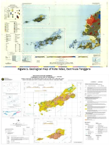
Bandung [7], most of the area has type Q1 Pleistosen or coraline limestone which were appears in soil periphery less than 60 %, while type Tmb is Bobonaro complex approximately about 30%. The remaining area consist of type QTn or Noele formation with some little part of the coastal area was type Qa or Alluvium (Holocene). The age of the stones was classified into Quaternary.
Hydrological characteristics
According to hydro geological aspect, Rote Ndao has classified as tropical regions where
watershed contain water in rainy season but water scare in dry season. Dry season has been identified long, about 7-9 month yearly. In Rote Nado Regency, Most of the area can be classified into Q types (quatenary) and T type (tertiary), with rainfall average about 500 - 1000 mm. About 10 % of area have akuifer land with moderates productivity, water surface depth, and water flow > 5 lt/s. Less than 60 % of lands have akuifer produktif with limited ground water flow and there are many cracking, water flow potential < 5 lt/s. About 30 % is considered rare ground water zone with low productifity.
Figure 1. Geological map of Rote Ndao, East Nusa Tenggara
J.Ind. Tour. Dev. Std., Vol.3, No.2, April, 2015 [72]
Geophysical Characteristic and Water Resources Availability in Rote Ndao (Tamelan)
Vegetation characteristics
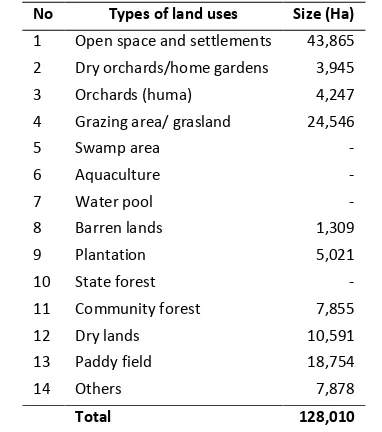
Based on the statistics document and official document from Regional Planning Agency (Bappeda) Rote Ndao Regency in 2013, the land covers in West Rote sub district was drawn bellow (Table 1).
Table 1. Land uses allocation in Rote Ndao Regency, 2013 No Types of land uses Size (Ha)
1 Open space and settlements 43,865
2 Dry orchards/home gardens 3,945
3 Orchards (huma) 4,247
4 Grazing area/ grasland 24,546
5 Swamp area -
11 Community forest 7,855
12 Dry lands 10,591
Local population and tourism in Rote Ndao
Based on the demographic data, the rate of population growth was recorded 1.6% yearly. The population density was estimated about 100 individual/km2. About 75% of the community activity is farming in dry land. Some people works in forestry and fisheries sectors. Agricultural sector is one of the important sector in Rote Ndao, but as far its productivity was low. Dry environment, lack of water and poor technology and human resources seems to be the limited factor for agricultural productivity. Increasing agricultural productivity requires sufficient water for agricultural irrigation. Problems related water availability is water scarcity which are becomes the crucial limiting factor for productivity.
Regional planning to integrate numerous sector of development has been drawn. In such a case, however, the capacity of provincial and local government to establish the proper regional
planning by involving water issues was
important. It is especially important when tourism was consider as a new economic actitivity in Rote Ndao. Tourism can be separated from water resources. The challenges for water resources management in newly tourism
destination is related to the water allocation for domestic needs, agriculture and tourism needs [8].
Tourism recently become intereting
phenomena in Rore Ndao. Tourism grows significantly in West Rote, Lobalain and Central Rote sub district (Table 2). Both domestic and international tourism grows significantly. In the perpectives of water resources, however, such situation should be responded by water resources management. Growth of tourist followed by increse of tourism accomodation (i.e. hotel, lodge, home stay) and other tourist facility which can be separated by water resources [2].
Table 2. Tourist growth in Rote Ndao Subdistrict International classified into several category, namely Class 1 : 0 – 8% (flat), Class 2 : 8 – 15% (flat), class 3 : 15 – 25% (moderate), class 4 : 25 – 45% (steep) and class 5 : > 45% (steepest). There flat area found in coastal zone of the island where some part is undulating and form basins. These situation provides opportunities for water accumulation which are to penetrates to soils. These is similar with Arsyad [10] and Dewi et al. [11] arguments. The infiltration capacity and ground water storage was influenced by number of water which was flow in the surface of lands, especially in its amount and rain intensity. The highest degrees of slopes increases the water surface flows, and therefore increase the soil erosion hazards.
In case of Rote Ndao Regency with Q1 soil types-coral limestone-, the infiltration potential was low, but such stone formation provides opportunities for rain water infiltration due to the structure have numerous pores. In the case of Tnb types in Bobonaro complex, there area potentially for highest infiltration. In such structure, however, there are some land
conservation techniques was needed to
J.Ind. Tour. Dev. Std., Vol.3, No.2, April, 2015
[73] Geophysical Characteristic and Water Resources Availability in Rote Ndao
(Tamelan)
to transfer water into soil. Soils texture basically has relationship with soil pore. In case soil pores abundance, the infiltration capacity was high. Sartohadi [12] found that soil pores volume affect the rate of infiltration. Soil with number of soil pores has low weight. Conversely, soil with low pores has high weight, thus has high ability to absorb water [13]. In case of natural resources management, there are needs of research and studies related to the infrastructure and
technology options to conserve water.
Unsustainable uses of lands lead the increase and rapid land degradation [14]. In such a case there are positive relationships with water catchment area management as a crucial source to generate
plant energy, irrigation, water spring
management and other domestics needs.
Hydrogeology
The hidrogeological profiles of land in Rote Ndao provides opportunities for water infiltration to soils. It is especially related to the soil litology composition and karsts with higest levels of soils porosity. These process produces ground water land conservation technology contributes to the negative impact water catchment area hydrology and water rivers quality of the area.
Having the important of infiltration process, there are important infiltration capacity research through hydrometereologic data and physical characteristics of water catchment area. It is similar with the case of sub-watershed Kreo which has highest rain fall in Garang water catchment area [18]. The water conservation therefore is important, especially in sustainable tourism lanning and development in Rote Ndao. In such a case, however, the detail and proper techniques was needed with special attention to the hydrogeological characteristics of location.
Vegetations dominated by settlement and home garden, and about 19% was feeding ground. The dry and barren lands was calculated about 8%. This figure shows that the number of vegetated area were
low and needs to be improved in order to enhance water conservation.
Vegetation was the important factor for water conservation because its ability to absorb and stored water in hydro geological process [19,20]. The roots of vegetation also contributes significantly in soil protections and water infiltration. The roots of vegetation has important role in increasing soil permeability and therefore increase water infiltration.
Tourism facility and infrastructure
development has been widely recognized contributes to the decreasing vegetation covers, especially in coastal area. Homegarden as a important spot in settlement area for water catchment area widely converted into numerous building and tourism facility to provides tourism basic needs. It is important for local government to drawn Regional Land Use Planning. Land uses
changes has significant consequence for
biodiversity and water conservation [2,21]. Forest and wildlife area conversation into settlement and tourism infrastructure affect negative impact of environment and biodiversity. Such changes contribute significantly to reduce natural water absorption zone and minimizersoil ability to absorb water.
J.Ind. Tour. Dev. Std., Vol.3, No.2, April, 2015 [74]
Geophysical Characteristic and Water Resources Availability in Rote Ndao (Tamelan)
CONCLUSION
Recent tourism development in Rote Ndao has close relationship with water issues. It is
especially important because Rote Ndao
physically located at dry environment where water scarcity become one of the crucial issues. Potential conflict between tourism and water can be minimized through proper water resources management. There are several important strategy to support water conservation in Rote Ndao. It is includes water infrastructure and
catchment reservoirs (embung) constructions,
bio-pore holes, re-vegetation of lands, especially in protected forest, production forest, home gardens and other potential locations as catchment reservoirs.
REFERENCES
[1] BPS and Bappeda Regency of Rote Ndao,
2014. Rote Ndao dalam angka. Rote Ndao.
[2] Hakim, L. 2002. Dasar-dasar Ekowisata.
Bayu Media, Malang.
[3] Desrainy. 2010. Karakteristik wilayah Peri Urban pada Metropolitan Jabodetabek-punjur. Working Paper. Regional and Rural Planning Resarch Group. Bandung Institute of Technology.
[4] Mendoza, M. E., E. Granados, D. Genelétti. 2011. Analysing land cover and land use change processes at watershed level: a multitemporal study in the Lake Cuitzeo Watershed Mexico (1975 -2003). Applied Geography 31, 237-250.
[5] Harp, S. L. 2007. Histories of tourism:
representation, identity and conflict.
Journal of Social History 41 (1), 220- 221. [6] Wisnawa, I M. B. and I K. Sutapa. 2014.
Konflik air bersih sebagai akibat pengem-bangan sarana pariwisata pada Kawasan
Bali Selatan dilihat dari perspektif
perundang-undangan. Jurnal Perhotelan dan Pariwisata 4 (1), 95.
[7] Geology Research and Development Centre
Bandung. 1996. Geology and Hydrogeology Map of Kupang Atambua 2205, East Nusa Tenggara.
[8] Mowforth, M and I. Munt. 2003. Tourism and sustainability: development and new tourism in the third world. Roudlege. [9] Asdak, C. 2010. Hidrologi dan pengelolaan
daerah aliran sungai. Gadjah Mada
University Press. Yogyakarta.
[10] Arsyad, S. 2010. Konservasi tanah dan air. Bogor Agricultural University Press. Bogor.
[11] Dewi, I G. A. S. U., N. M. Trigunasih, and T. Kusmawati. 2012. Prediksi erosi dan perencanaan konservasi tanah dan air pada
Daerah Aliran Sungai Saba. E-Jurnal
Agroekoteknologi Tropika 1 (1).
[12] Sartohadi, J. 2012. Pengantar geografi
tanah. Pustaka Pelajar. Yogyakarta.
[13] Effendi, A. D. 2008. Identifikasi kejadian longsor dan penentuan faktor - faktor utama penyebabnya di Kecamatan Babakan Madang Kabupaten Bogor. Faculty of Forestry, Bogor Agricultural University. Bogor.
[14] Sylviani. 2010. Potensi dan pemanfaatan sumberdaya air di Daerah Aliran Sungai Jeneberang dan Kawasan Hutan Lindung (Studi kasus di Kabupaten Gowa, Propinsi
Sulawesi Selatan). Jurnal Penelitian.
Makassar.
[15] Hasmar. H. 2010. Drainase terapan. Islamic University ofIndonesia Press. Yogyakarta. [16] Hariyono. 2011. Uji bakteriologis air di
Kecamatan Semampir Surabaya. Airlangga Universitas.
[17] Alwi, L. O. and M. Sitti. 2014. Dampak penggunaan lahan terhadap sumber daya air: Studi Literatur Dan Hasil Penelitian, Universitas Halu Oleo, Kendari. Jurnal Agroteknos 4 (2), 134-145.
[18] Suhandini. 2011. Banjir bandang di DAS Garang Jawa Tengah (penyebab dan implikasinya). PhD Thesis. Faculty of
Geography, Gadjah Mada University.
Yogyakarta.
[19] Chen, H., J. Liu, W. Zhang W., and K. Wang. 2011. Soil hydraulic properties on the steep karst hillslopes in northwest Guangxi China. Journal of Environment Earth Science, 1-9. [20] Eze, E.B., D.I. Eni, and O. Comfort. 2010.
Evaluation of the infiltration capacity of soils in Akpabuyo local geverment area of Cross River, Nigeria. Journal of Geography and Geology 3 (1), 189-190.
[21] Azmeri, H. B. and N. Herissandy. 2012.
Analisis pengaruh perubahan lahan
terhadap ketersediaan air DAS Krueng Meureudu. Faculty of Engineering, Syiah Kuala University. Jurnal Ekonomi dan Pembangunan 3 (1).