Interstratified Illite/Montmorillonite
in Kamojang Geothermal Field, Indonesia
Perselingan Ilit/Monmorilonit di Lapangan Geotermal
Kamojang, Indonesia
D.F.YuDiantoro1, E. Suparka2, S. Yuwono2, i. takaShima, D. iShiYama3, Y. kamah4, and J. hutabarat5
1Geological Engineering, UPN “Veteran” Yogyakarta, Indonesia 2Geological Engineering, Institute of Technology Bandung, Indonesia
3Centre for Geo-Environmental Science, Akita University, Japan 4Pertamina Geothermal Energy, Indonesia
5Faculty of Geology, Padjadjaran University, Indonesia
Manuscript received: June 19, 2012; revised: May 13, 2013; final acceptance: December 13, 2013 Corresponding Author: d_fitri4012@yahoo.com
AbstrAct
Kamojang geothermal field located in West Java Province, falls under the Pangkalan Subregency,
Bandung Regency. The researched area is a geothermal field located in the Quaternary volcanic caldera system of about 0.452 to 1.2 Ma. The volcanic activity generated hydrothermal fluids, interacting with rocks producing mineral alteration. The minerals formed in the areas of research are interstratified illite/ montmorillonite (I/M). Analyses to identify interstratified I/M have been performed by X-ray diffraction using ethylene glycol, while the determination of the type and percentage of interstratified I/M was based on the calculation method of Watanabe. The methodology was applied on core and cutting samples from Wells KMJ-8, 9, 11, 13, 16, 23, 49, 51, and 54. The result of analysis of the samples shows that the type of clay is interstratified illite/montmorillonite and the minerals are formed at temperatures ranging from 180 to 220° C. The type of interstratified I/M in the studied area is S = 0 and S = 1. The percentage of illite type S = 0 is between 20 - 35% illite, whereas type S = 1 has about 45 - 72% illite. Along with the increasing depth, the percentage of illite is getting greater. This is consistent with the vertical distribution of temperature which increases according to the depth. This correlation results in an interpretation that the upflow zone of the geothermal reservoir is located in the centre of the Kamojang geothermal field.
Keywords: geothermal, Kamojang, fluid, illite, montmorillonite, interstratified
AbstrAk
Lapangan panas bumi Kamojang yang terletak di Provinsi Jawa Barat, secara administratif termasuk ke dalam Kecamatan Pangkalan, Kabupaten Bandung. Daerah penelitian merupakan lapangan panas bumi yang terletak di kaldera gunung api Kuarter yang berumur sekitar 0,452 sampai 1,2 juta tahun. Hasil kegiatan
gunung api ini menghasilkan cairan fluida, yang berinteraksi dengan batuan dan menghasilkan mineral
ubahan. Mineral ubahan yang terbentuk di daerah penelitian ini adalah perselingan ilit/monmorilonit (I/M).
Analisis untuk mengidentifikasi perselingan I/M telah dilakukan menggunakan difraksi X-ray dengan etilen
glikol, sedangkan penentuan tipe dan persentase perselingan I/M didasarkan pada metode kalkulasi Wata
-nabe. Metodologi ini diterapkan pada inti dan percontoh dari sumur KMJ-8, 9, 11, 13, 16, 23, 49, 51, dan
54. Hasil analisis percontoh memperlihatkan bahwa tipe lempungnya adalah perselingan ilit/monmorilonit
dan mineral tersebut terbentuk pada temperatur yang berkisar antara 180 - 220o C. Perselingan tipe I/M
di daerah penelitian adalah S=0 dan S=1. Persentase tipe ilit S=0 antara 20 - 35%, sedangkan pada tipe
IntroductIon
The structure of mixed-layer clay minerals have been used as geothermometers in geothermal studies, because the structure of the mixed-layer clay has a significance as an indicator sensitive to changes in temperature and chemical environments. In this study, the interstratified mixed-layer illite/montmorillonite (I/M) were found in samples obtained from rock alteration in Kamojang geothermal field. The wells were selected, that are: wells KMJ-8, 9, 11, 13, 16, 23, 49, 51, and 54. Interstratified mixed-layer illite/montmorillonite (I/M) is a sequence of transformations between montmorillonite-illite minerals produced due to the increased temperature of the hydrothermal system in the field of geothermal Kamojang. The analytical methods used to identify mixed-layer illite-montmorillonite is the method of X-ray diffraction analysis using ethylene glycol.
GeoloGyof KAmojAnG
The Kamojang geothermal field is located in an area surrounded by a series of active volcanoes. The field length is 15 km and the width is 4.5 km. The area is bordered by Rakutak Mount in the west and Guntur Mount in the east. The mountainous area is composed of a number of volcanoes lining east-west including Rakutak Mount, Ciharus Lake, Pangkalan Lake, Gandapura Mount, Guntur Mount, and Masigit Mount. The age of Rakutak Mount is older than Guntur and both are still active. The development of this volcanic chain can be observed from the alignment of magmatic center of the volcanoes which began to develop from west to east. The regional stratigraphy of the Kamojang Field has been compiled by Robert et al. (1983)
based on data from shallow and deep drillings. The Kamojang area consists of two formations (from older to younger), the Pangkalan and Gandapura
Formations. The Pangkalan Formation is 1.2 ± 0.02 My in age occupying the western part, while Gandapura Formation is 0.452 ± 0.05 My in age and occupies the eastern part of Kamojang.
Hydrothermal alteration minerals of Kamojang geothermal area have been studied by many workers including Purba (1994), Yudiantoro (1997), Utami (2000) and Kamah et al. (2003). The hydrotermal
minerals occurring in the field of geothermal Kamojang according toYudiantoro (1997), can be divided into three zones, namely Kaolinite-Montmorillonite, Anhydrite-Calcite, and Epidote-Chlorite Zones. Kaolinite-Montmorillonite and Anhydrite-Calcite Zones are located at a shallow depth, which is the cap rock of the geothermal system. While the Epidote-Chlorite zone occupies a deeper level as a reservoir zone. Utami (2000) divided the type of mineral alteration zonation based on hydrothermal fluid. The acid alteration mineral assemblage includes kaolinite with or without smectite, alunite, quartz, cristobalite, and pyrite. The mineral assemblage is located at a shallow depth of about 100 - 300 m. Whereas neutral mineral assemblage consists of epidote, titanit, wairakit, laumontit, calcite, hematite, pyrite, chlorite, illite, and interstratified clay. Neutral mineral assemblage is located at a deeper depth. According to Kamah et al. (2003), geothermal field can be divided
into argillic and propylitic zones. Argillic zone is dominated by clay minerals consisting of kaolinite (< 120o C ), smectite (< 150o C), and smectite-illite (> 200o C) formed in acidic conditions near neutral (steam) zone. The assemblage minerals of propylitic zone are in depths at temperatures of above 200o C and has been interpreted as a reservoir zone. The minerals existing in this zone are epidote, adularia, wairakit, nonswelling chlorite, and calcite. Based on the analysis of fluid inclusions, Purba (1994) showed that the reservoir temperature at well KMJ-53 in 710-712 m depth ranges between 262- 263o C, the temperature is higher than that obtained from measurements of temperature at a depth of 710 m that is equal to 243o C.
S=1 adalah sekitar 45 - 72%. Seiring dengan pertambahan kedalaman, persentase ilit menjadi lebih besar. Hal ini konsisten dengan distribusi vertikal temperatur yang meningkat sesuai kedalaman. Korelasi ini menghasilkan suatu interpretasi bahwa zona aliran atas reservoar panas bumi terletak di tengah lapangan panas bumi Kamojang.
methodoloGy
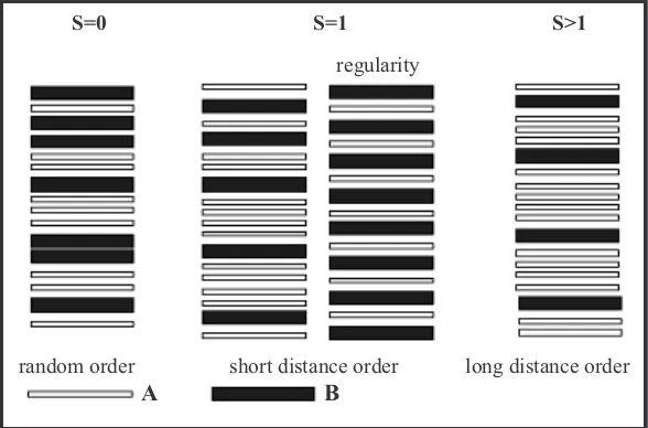
Identification of interstratified illite/montmoril -lonite (I/M) in this study used X-ray diffraction of dry powder and ethylene glycol methods. Inter -stratified or mixed-layer minerals are formed by the composition of trioctahedral and dioctahedral layers and are extremely rarely-found mineral. Interstratified I/M is a two-component mixed-layer minerals composed of dioctahedral illite and mont-morillonite. Mixed-layer minerals are identified as components, proportions, and levels of composition order that has been determined. As a parable, the mixed-layer minerals consisting of two components A-B. The two components are probabilities and be grouped into types of Random Sequence Stacking (S0) and Maximum Degree of Order (S1). Random Sequence Stacking (S0) is a sequence of random stacking, layer A can be followed by A or B layer without provisions sequence (Figure 1). While the Maximum Degree of Order (S1) is a sequence of layers with the provisions of the order, for ex -ample, when a layer of clay mineral composition of sequences is composed of 10 layers containing 40% B, hence the sequence arrangement applied as follows: B-A-B-A-A-B-A-B-A-A. The sequence may be present, but when the order as B-A-A-A-B-B-A-B-A-A, then it is not allowed. A long-range order can be formed with at least two or three in a row A after each B. Thus the interstratified illite/
montmorillonite has a layer variation between il -lite/montmorillonite. This is caused by a rise in temperature hydrothermal alteration (Inoue, 1995). Illitization process of montmorillonite will also show the change in the proportion of illite layers (% I) with a sequence called reichweite. The composi -tion of the illite/montmorillonite in the sequence are stacked vertically along the c axis* in which changes take place systematically. Thus, the char-acteristic mineral composition layering between illite and montmorillonite will be expressed by two variables, namely % M (or %I) and reichweite (Moore and Reynolds, 1997).
Some methods used to determine the value of %I in I/M have been proposed by many research -ers, for example the Saddle/001 peak intensity method (Weir et al., 1975; Rettke, 1981; Inoue et al., 1989), Srodon method (Srodon, 1980, 1981),
and Δ2θ1-Δ2θ2 methods (Watanabe 1981, 1988). In the method Δ2θ1-Δ2θ2 of Watanabe (1981), Δ2θ1 is defined by an angular difference between a peak (l2) at 8.9-10.2°2θ (Cu Kα radiation) and a peak (l1) at 5.1-7.6°2θ, and Δ2θ2 is an angular difference between a peak (l3) at 16.1-17.2°2θ and l2. These Δ2θ1 and Δ2θ2 values show systematic changes with expandability (%M) at constant reichweite (given by each curve in Figure 2). Plotting them in the diagram gives the benefit of showing both %M and reichweite at the same time.
Figure 1. Schematic diagram of randomly ordered, ordered, and regularly ordered interstratifications of two types of A and B layers such as illite (10 Å) and montmorillonite (17 Å) (Meunir, 2005).
S=0 S=1 S>1
S=0 S=1 S>1regularity
order short distance order long distance order random
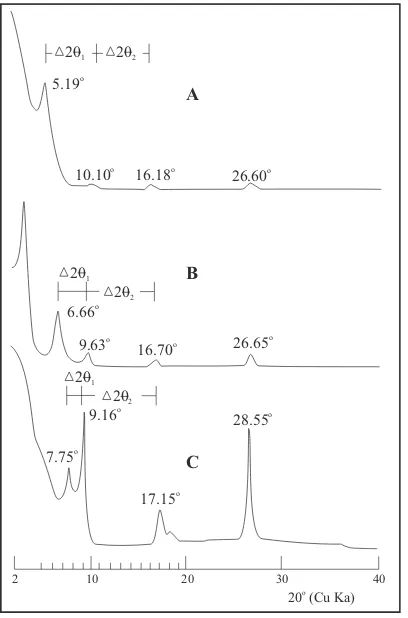
Figure 2. Curve of interstratification illite/montmorillonite. A, B, and C are the curve interstratification illite/montmoril
-lonite, which is used as an example of the calculation in de
-termining the type of interstratification illite/montmorillon
-ite. Δ2θ1 and Δ2θ2 value on the diagram represents the value of the difference in the angle of reflection (Cu Kα radiation) (Watanabe, 1981).
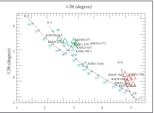
Figure 3. Diagram for identification of interstratified illite/ montmorillonite. Δ2θ1 and Δ2θ2 value on the diagram repre-sents the value of the difference in the angle of reflection (Cu Kα radiation) (Watanabe, 1981).
resultAnd dIscussIon
Variations in the composition of illite/montmo -rillonite
X-ray diffraction analysis using ethylene glycol to the core and samples from Wells KMJ-8, 9, 11, 13, 16, 23, 49, 51 and 54 shows that the samples contain interstratification illite/montmorillonite. Calcula -tion method to determine the type and percentage interstratification illite/montmorillonite uses the variation Δ2θ1-Δ2θ2 method of Watanabe (1981).
From the analysis on interstratification of illite/ montmorillonite using diagrams Watanabe (1981) for examples of rock alteration in the researched area, it is found that the type of interstratified illite/ montmorillonite is S = 0 and S = 1.
Pattern diagram of X-ray diffraction analysis of rock samples KMJ9 (454.8 m, 609.8 m. 760 m), KMJ51 (363 m), and KMJ54 (798 m) show that the structure of S = 0 , as displayed in Figure 4. In this pattern, interstratified illite/montmorillonite show characteristic values of 5.2 - 5.5o2θ
1, 16.04 - 17.11 Å; 10.15 - 10.6o 2θ
2, 8.37 - 8.65 Å; and 16 -16.4 o 2θ3, 5.42 - 5.54 Å.
While the values obtained from the calculation Δ2θ1 range from 4.8 - 5.1
o, and from Δ2θ
2 range be-tween 5.7 - 6.1o. The calculation results are presented in Table 1. From the result of variation diagram diagram Δ2θ1 and Δ2θ2 plotting, the obtained values of S = 0 varies from 20 - 30% illite. Plotting of the result can be seen in Figure 5.
This study is to determine the types of inter-stratified I/M using a variation diagram Δ2θ1 and Δ2θ2 of Watanabe (1981). This first calculating can be traced as follows: 2θ2 - 2θ1 = Δ2θ1 and 2θ3 - 2θ2 = Δ2θ2. The results of these calculations will result in Δ2θ2 and Δ2θ1 values. Calculation results of Δ2θ2 and Δ2θ1 are then plotted on the diagram variation Δ2θ2 and Δ2θ1, so the values of the proportion of interstratified illite/montmorillonite will be obtained. For example, the calculation as follows:
The pattern variation of interstratified I/M type S = 1 can be seen in Figure 6, using samples of KMJ8 (306.7 m, 623.2 m, 638.4 m), KMJ11 (167.2 m), KMJ13 (202.5 m), KMJ16 (113 m), KMJ23 (199.7 m), and KMJ49 (205.8 m).
This pattern of interstratified illite/montmoril -lonite has a variation of 6.0 - 6.6o2θ
1, 13.28 - 14.81 Å; 9.1 - 9.6o2θ
2, 9.17 - 9.75 Å and 16.2 - 16.85 o2θ
3, 5.31 - 5.46 Å. Δ2θ1 values obtained from the cal-culations ranging from 2.5 to 3.4o and Δ2θ
2 values range between 6.5 - 7.5o. The calculation results are presented in Table 1. From the results of plotting
the variation diagram Δ2θ1 and Δ2θ2, the obtained value of S = 1 ranges from 45-72% illite. Plotting of the results can be seen in Figure 6.
The presence of interstratified illite/mo ntmoril-lonite is located at an elevation between 800 - 200 m. Plotting the percentage of illite with the results on the depth of each well shows that the percentage of illite increases towards depths (Figure 7). This is consistent with the vertical distribution of temperature, that the greater the depth, the higher the geothermal temperature. According to Steiner (1968) and Browne (1978) temperature index of
Figure 4. Results of X-ray diffraction analysis using ethylene glycol on sample KMJ-9, 51 and 54. Interstratified illite/ montmorillonite type is S= 0.
KMJ53-798 KMJ51-363 KMJ9-760 KMJ9-609.8 KMJ9-454.8
16.04-17-1
1A
8.37-8.65A 5.42-5.54A
Intensity (cps)
2500
2000
1500
1000
500
0
2 3 4 5 6 7 8 9 10 11 12 13 14 15 16 17 18 19 20
20
20 (degree)1
S=1
S=0 S=2
85
80 75
75
70 70 65
60 60 55
50 45
40 35
30 25
2015
10
0
20
(degree)2
KMJ49-677
KMJ23-657 KMJ16-372
KMJ13-666 KMJ11-550 KMJ8-638.4
KMJ8-623.2
KMJ8-306.7
KMJ53-798
KMJ51-363 KMJ9-760
KMJ9-609.8 KMJ9-454.8
1 2 3 4 5 8
7
6
5
2000
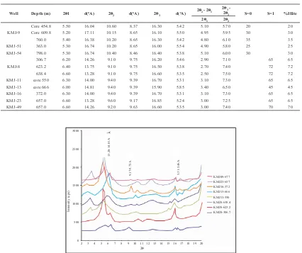
Figure 7. Plot of illite percentage with depth and temperature measurement.
Well Depth (m) 201 d(oA) 20
Core 454.8 5.50 16.04 10.60 8.37 16.30 5.42 5.10 5.70 20 20
Core 609.8 5.20 17.11 10.15 8.65 16.10 5.50 4.95 5.95 30 30
760.0 5.40 16.38 10.20 8.65 16.30 5.42 4.80 6.10 35 35
KMJ-51 363.0 5.30 16.74 10.20 8.65 16.00 5.54 4.90 5.80 25 25
KMJ-54 798.0 5.30 16.74 10.40 8.46 16.40 5.38 5.10 6.00 30 30
KMJ-8
306.7 6.20 14.26 9.10 9.75 16.20 5.46 2.90 7.10 65 65
623.2 6.40 13.75 9.10 9.75 16.50 5.38 2.70 7.40 72 72
638.4 6.60 13.28 9.10 9.75 16.60 5.35 2.50 7.50 72 72
KMJ-11 core 550 6.30 14.00 9.40 9.39 16.70 5.31 3.10 7.30 65 65
KMJ-13 core 666 6.00 14.81 9.40 9.39 15.90 5.85 3.40 6.50 45 45
KMJ-16 372.0 6.30 14.00 9.40 9.39 16.70 5.31 3.10 7.30 65 65
KMJ-23 657.0 6.60 13.28 9.60 9.17 16.85 5.24 3.00 7.25 65 65
KMJ-49 657.0 6.60 14.26 9.20 9.63 16.60 5.35 3.00 7.40 70 70
Table 1. Calculation Results Interstratified Illite/Montmorillonite Using Calculation Methods of Watanabe (1981) show Types Interstratified S = 0, S = 1 and % illite
Figure 6. Results of X-ray diffraction analysis using ethylene glycol on sample of KMJ-8, 11, 13, 16, 23 and 49. Interstratified illite/montmorillonite type is S = 1.
illite/montmorillonite is about 180 - 220° C. When it is correlated with the temperature measurements of well conducted by Pertamina (2010), the temperature of interstratified illite/montmorillonite zone is located in the region of about 100 - 200o C (Figure 7). The correlation results also indicate that the upflow zone of geothermal reservoir is located in the center of the Kamojang geothermal field.
conclusIon
Based on the analysis of interstratified illite / montmorillonite using Watanabe diagram (1981) of alteration rocks in the studied area, the results obtained indicate that the types of interstratified illite/ montmorillonite are S = 0 and S = 1.
The result of plotting on the variation Δ2θ2 and Δ2θ1 diagram shows that the value S = 0 varies from 20% to 35% illite, while the value of S = 1 ranges from 45% to 72% illite.
The results of illite percentage that plot on depth of each well show that the percentage of illite is greater along with increasing depths. This is consistent with the vertical distribution of temperature, that at the greater depth, geothermal temperature is higher. When correlated with the temperature measurements of well, the interstratified illite/montmorillonite zone is located in the temperature region around 100- 200o C. The correlation also interprets that the upflow zone of geothermal reservoir is located in the centre of the Kamojang geothermal field.
Acknowledgements--- The authors extend gratitude to the
Akita University Japan and LPPM UPN “Veteran” Yogyakarta, Indonesia, who have supported this study with facilities. The
gratitude is also addressed to Pertamina Geothermal Energy for
permission to publish this paper. The authors wish to express
their appreciation to Dr. C. Prasetyadi (Geological Engineering
UPN “Veteran” Yogyakarta, Indonesia) for reading the original
manuscript and offering many constructive criticisms.
refrences
Browne, P.R.L., 1978. Hydrothermal Alteration in Active
Geothermal Fields. Earth Planet Set, p.229-250.
Inoue A., Bouchet A., Velde B., and Meunier A., 1989.
Convenient Technique For Estimating Smectite Layer Percentage in Randomly Interstratified Illite/Smectite
Minerals. Clays and Clay Minerals 37, p.227-234.
Inoue A., 1995. Formation of Clay Minerals in Hydrothermal
Environments. In: Bruce Velde (ed.), Origin and Mineralogy of Clay. Springer-Verlag, 334pp.
Kamah, Y., Tavip, D., and Agus, A.Z., 2003. Penanggulangan
Problem Geologi Dalam Operasi Pemboran Sumur Di Blok Timur Area Geothermal Kamojang Jawa Barat
Indonesia. Proceedings of 6th Indonesian Geothermal
Association, p.175-184.
Moore, D.M. and Reynolds, R.C.Jr., 1997. X-Ray Diffraction
and the Identification and Analysis of Clay Minerals.
Oxford University Press, Inc.378pp.
Meunir, A., 2005. Clays. Springer, 472pp.
Pertamina, 2010. Pengukuran Temperatur dan Tekanan.
Laporan internal.
Purba, S., 1994. Hydrothermal Alteration of Core and
Cutting Samples From Wells KMJ-48 and 53 Kamojang
Geothermal Field West Java Indonesia. 58pp.
Rettke, R.C., 1981. Probable Burial Diagenesis And
Provenance Effects On Dakota Group Clay Mineralogy.
Denver Basin. Journal of Sedimentary Petrology, 51,
p.541-551.
Robert, D., Raharso, R., and Bastaman S., 1983. Exploration and Development of the Kamojang Geothermal Field.
Proceedings of IPA, p.171-190.
Srodon, J., 1980. Precise Identification of Illite/Smectite Interstratified by X-ray Powder Diffraction. Clays and Clay Minerals, 28, p.401-411.
Srodon, J., 1981. X-ray Identification of Randomly Interstratified Illite-Smectite in Mixtures With Discrete
Illite. Clays and Clay Minerals.16, p.297-304.
Steiner, A., 1968. Clay Minerals in Hydrothermally Altered
Rocks at Wairakei. New Zealand. Clays and Clay Minerals. 16, p.193-213.
Utami, P., and Browne P.R.L., 1999. Subsurface Hydrothermal Alteration in the Kamojang Geothermal Field West Java
Indonesia. Proceedings 24th Workshop on Geothermal
Reservoir Engineering.
Utami, P., 2000. Characteristics of the Kamojang Geothermal
Reservoir (West Java) as Revealed By Its Hydrothermal
Alteration Mineralogy. Proceedings World Geothermal
Congress, p.1921-1926.
Watanabe, T., 1981. Identification of Illite/Montmorillonite Interstratifications bay X-ray Powder Diffraction.
Journal of Mineral Society of Japan, Special Isseu.
p.97-114.
Watanabe, T., 1988. The Stuctural Model of Illite/Smectite
Interstratified Minerals And The Diagram For Its
Identification. Clay Science, 7, p.97-114.
Weir, A.H., Ormerod, E.G., and ElManasey, I.M.I., 1975. Clay Mineralogy of Sediments of The Western Nile Delta. Clay Mineral 10, p.369-386.
Yudiantoro, D.F., 1997. Kimia Batuan Ubahan Hidrotermal
Sumur KMJ-49 dan Sumur KMJ-57 Lapangan Panasbumi Kamojang Jawa Barat. Tesis Magister