IJOG
INDONESIAN JOURNAL ON GEOSCIENCE
Geological Agency
Ministry of Energy and Mineral Resources
Journal homepage: h�p://ijog.bgl.esdm.go.id ISSN 2355-9314 (Print), e-ISSN 2355-9306 (Online)
Wrench-Slip Reversals and Structural Inversions: Cenozoic Slide-Rule
Tectonics in Sundaland
H.D. Tjia
Institute for Environment and Development University Kebangsaan Malaysia 436000 UKM Bangi, Selangor, Malaysia
Corresponding author: [email protected]
Manuscript received: January 17, 2014, revised: March 12, 2014, approved: April 10, 2014
Abstract - Most of continental Southeast Asia, that is, Sundaland and Indosinia, achieved a relative tectonic stability by the beginning of the Cenozoic. Since then a strong tectonic activity in Sundaland has been restricted to existing regional fault zones and to regional slow, vertical crustal movements elsewhere that produced small to very large sedimentary basins. On the other hand, regional deformation of Indosinia as a consequence of ductile shearing has continued into the Paleogene. Since the Oligocene, the northern part of Sundaland and Indosinia have been extruded differentially towards southeast along the Red River, Wang Chao (or Mae Ping, or Tonle Sap), and Three Pagodas - Axial Malay fault zones. The initial cause has been attributed to hard collision between Subplate India with Megaplate Eurasia. Plate dynamics in the region have changed substantially since Mid-Miocene as to force wrench-slip reversals along the major fault zones in Sundaland as well as in Indosinia. Concomitant structural inversions are demonstrated on seismic sections. In the core of Sundaland, earlier transtensional wrenching was succeeded by transpressive strike-slip faulting that on major faults of the Malay Basin manifested in reversals of sense. From the Hinge-line fault eastward, the transtensional left wrench slip was succeeded by transpressional dextral slip, while in the region to its west the wrench-slip kinematics was an earlier transtensional right slip followed by transpressional left slip. In the Strait of Malacca and eastern margin of Sumatra, right-lateral wrenching in the Neogene has been common. In certain places it could be established a wrench-slip of transtensional character in Oligocene-Early Miocene, and the transpressional wrench movement occurred mainly during the Middle to Late Miocene. The remarkable coincidence of termination of spreading of the South China Basin in Langhian, and that of the West Philippine and Caroline basins during Mid-Miocene invites further study.
Keywords: transtensional vs. tranpressional wrenching, sequence, domains delineation
Introduction
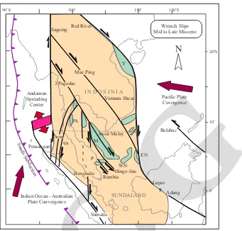
Sundaland forms the southern part of the Southeast Asian Subplate, whilst the northern portion of the subplate is usually referred to as Indosinia (Figure 1). Pre-Tertiary outcrops are widespread. The two geological terrains can be
artificially separated by the 9 degrees northern
latitude. The Red River fault forms the northern border; the Sagaing demarcates the western limit, and the Vietnam Shear separates Indosinian nental block from the oceanic and thinned conti-nental crusts of the South China Sea region. The three regional wrench faults, all striking
North-west, cut Indosinia into large elongated crustal slabs. These faults are the Red River, Wang Chao (or also called Mae Ping or Tonle Sap), and Three
Pagodas. Tapponnier et al. (1982) suggested that
these regional fault zones possessed left-lateral strike-slip that facilitated extrusion of the crustal slabs towards southeast. This hypothesis attributes sustained collision of the Indian Subplate against the Eurasian megaplate at the Tibetan region as the cause. The tectonic extrusion of Indosinia has been adopted as a working model by many practicing
geologists of the region.
Further investigations showed that wrench-slip reversals had occurred on the three fault
IJOG
zones. Lacassin et al. (1997) supported wrench re
-versals and structural inversions with 40Ar/39Ar
dated metamorphic rocks, which were interpreted to imply that left-lateral slips occurred in Oligo-cene - Early MioOligo-cene, while dextral wrench slips of the faults occurred in the Pliocene-Quaternary time span. A major argument supporting the changes concerns continuous northward progres-sion of the Indian Subplate colliprogres-sion that has
produced a clockwise rotation of over 100o of
the regional stress fields of Indosinia. Rhodes et
al. (2005) interpreted three tectonic stages for the
Three Pagodas Fault zone: (1) initially as a wide ductile left-lateral shear zone in a transpressive environment; (2) followed by individual fault strands of the TPFZ becoming right-slip trans-tensional; and (3) renewed activity (Holocene?) right-lateral transpressional with small dextral slip in the Northwest of the TPFZ. Exploration for hydrocarbons in the Malay, West Natuna and
Penyu basins in the core of Sundaland and also in Tertiary basins located along its western and southern fringes produced a plethora of relevant
data pertaining to regional stress field changes (Tjia and Liew, 1996). The main objective of the
current article is to deal with Cenozoic kinemat-ics of wrench faulting and structural inversions in Sundaland. A few unpublished/lesser known indicators from Indosinia are included. Relevant structural information is also scattered in the
pe-troleum geology book of Petronas (1999).
Note: Before the age of electronic calculators, a wide range of computations was performed by
sliding back-and-forth parts of a slide rule (
mis-tarhitung). Elongated crustal slabs of Sundaland
moved in similar fashion along wrench faults. The term “slide rule tectonics” is here intro-duced to encompass the development of regional wrench-slip reversals and associated structural inversions. Mid to Late Miocene
Pacific Plate
Indian Ocean - Australian Plate Convergence
Figure 1. Index map of the Southeast Asian Subplate comprising Sundaland and Indosinia. Pre-Tertiary outcrops are wide-spread. Wrench-slips in Sundaland during Middle to end of the Miocene. Sundaland is arbitrarily separated from Indosinia
by the 9 degrees northern latitude. Wrench-slips in the main Malay Basin and in its western ramp have been different. The
IJOG
Regional geology
Indosinian Slide-Rule Tectonics
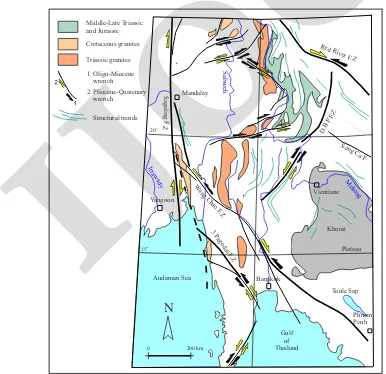
Tapponnier et al. (1982) proposed a tectonic
model of large scale extrusion of the Indosinian continental plate by left-lateral wrenching along regional fault zones: Red River, Mae Ping/Wang Chao, and Three Pagodas. This model is purport-edly consistent with the Indian Subplate collid-ing with the Eurasian Megaplate. The proposers supported their hypothesis with laboratory
ex-periments using plasticine. Lacassin et al. (1997)
showed that the three regional fault zones were subject to wrench reversals and inversions. Since the Late Neogene the three named faults produced right-lateral wrenching (Figure 2). The effects of initial left-lateral wrench slip have not been fully restored by the later reversals.
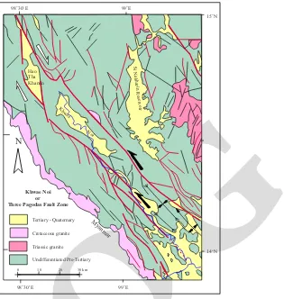
Right-lateral wrenching on the Three Pagodas Fault Zone is also indicated in Figure 3. This
map fragment is simplified from the Geological
Surveyof the Department of Mineral Resources
(Thailand) regional map published in 1983. The
Three Pagodas Fault Zone (TPFZ) along the Kh-wae Noi segment has several Neogene (Tertiary-Quaternary) depressions. The Hao Tha Khanun (or Pracham) Basin has a rhombic plan that suggests
a pull-apart 40 - 45 km long filled with
Neogene-Quaternary sediments. This pull-apart basin is consistent with dextral wrench on the TPFZ, a clear reversal of the sinistral sense (black half-tipped ar-row) that characterizes its earlier activity. Fenton
et al. (2003) believed that faults in northern and
western Thailand (including the Three Pagodas Fault Zone) indicate a recent activity. Lateral slip rates were estimated at 0.5 to 2 mm.
Middle-Late Triassic and Jurassic Cretaceous granites
Triassic granites
Red River F .Z
Mandalay
Sagaling F
.Z
Song Ca F
D.B P F.Z
Yangoon Irrawady
Salweeh
3 Pagodas F
.Z
Vientiane
Khorat Mekong
Wang Chao F
.Z
Plateau
Bangkok Andaman Sea
o
20
o
15
0 200 km
Tonle Sap
Gulf of Thailand Structural trends
1. Oligo-Miocene wrench
2. Pliocene-Quatenary wrench
N
PhnomPenh
Figure 2. Major structures, especially fault zones in Indosinia. The geology is simplified from Lacassin et al. (1997) that
highlight regional drag effects by the major faults. These effects show case the significance of Paleogene wrench faulting,
IJOG
Along its SE-strike, the Three Pagodas Fault Zone is likely to extend into the Malay Basin as its Axial Malay Axial Fault Zone. Wrench reversal from an earlier sinistral sense into dextral strike
slip has been demonstrated (Tjia and Liew, 1996).
However, the wrench kinematics of the TPFZ and AMFZ has been in opposite sequence.
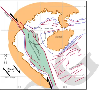
The Yinggehai depression marks the transi-tion between the Red River Fault Zone and the Vietnam Shear (Figure 4). The rhombic outline of the depression suggests a pull-apart produced by right-lateral wrenching. The outline is based
on a map by CCOP (1991). The Vietnam Shear
separates a combination of oceanic and thinned continental crust of the South China Sea Basin from normal continental crust of
Indosinia-Sun-daland (Taylor and Hayes, 1983; Roques et al.,
1997). The shear is most likely a transform fault (Sandal, 1996, Figure 2.1; and Tjia (1998). The
shear’s activity may have begun with the opening
of the South China Sea Basin dated at 32 Ma, or within the later part of the Oligocene. Tapponnier
et al. (1982) assigned left slip exceeding 500 km
on the Red River Fault Zone. This probably oc-curred during the Paleogene. A morphotectonic
study by Zuchiewicz and Cuong (2009) cite ear
-lier results on the RRFZ and note that left slip overlaps with the opening of the South China Sea Basin in the 34 to 17 Ma period, with estimated total displacement of 300 + 60 km to as much as 500 - 700 km. Since the end of Miocene, right-lateral slip may have reached a total of 200 - 250 km. Quaternary dextral slip has been in the 300 m to 2 km range representing an average annual rate of 5 mm.
Four recent earthquakes have epicenters at the ends of the Red River and the Mae Ping fault zones (Figure 5). The two shallow earthquakes
(focal depths < 33 km) near Hainan Island show
first-motion solutions of right-lateral wrenching
Hao Tha Khanun
Khwae
Noi
Tertiary - Quaternary Cretaceous granite Triassic granite Undifferentiated Pre-Tertiary
0 10 20 30 km
Myanmar
Khwae Noi or Three Pagodas Fault Zone
Si Nakharin Reservoir
N
o
15 N
o
14 N
o
98 30' E 99o E o
98 30' E 99 Eo
Figure 3. Simplified regional geology of western Thailand based on the Geological Survey of the Department of Mineral Resources (1983). Half-tipped black arrows indicate strike-slip sense on the Three Pagodas Fault Zone in pre-Mid Miocene.
IJOG
Red River Faultpull-apart by dextral wrenchYinggehai Basin
Beibu Wan
o 22 N
o 20
o 18
o 16 N
o o o
106 E 108 110 E
Southeast Hainan
Stress Ellipse
Hainan
1 km 1 km
1 km
Sediment thickness 1 km
N
100 E
20 N
1994 12 31
South Shina Sea Basin (Oceanic Crust)
2005 11 07
2007 02 24F 1995 01 10
1991 05 26
Tubau Fault 2004 05 01
1995 07 12 Ranau Mw 5.5
Mw 5.3
Mw 5.3
Mw 5.4
Mw 5.2
Mw 5.5 Mw 5.3
2005 11 08
10
0 N
110 120 E
20 N
10
0 N
N
110 120
Figure 4. The Yinggehai depression marks the transition between the Red River Fault Zone and the Vietnam Shear. Its outline
suggests a pullapart produced by right-lateral wrenching. The outline is based on a map by CCOP (1991).
IJOG
on NW-trending segments of the Red River Fault Zone. Two of the moderate-magnitude earthquake epicenters are located at the end of the Mae Ping Fault zone and also possess shallow foci of < 33 km. The “beach balls” are consistent with right lateral slip on NW - SE striking faults. Both the RRFZ and MPFZ are active.
Sundaland Slide-Rule Tectonics
Malay Basin, West Natuna, and Penyu Basins
Malay Basin (1)
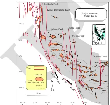
In Figure 6, the Malay Basin occupies the gre
y-shaded region. Regional faults striking within the NW to N sector form the western limit of the basin. Black half-tipped arrows indicate initial wrench sense on the Dungun, Hinge-line, and Tenggol Faults. Dextral slips produced relatively
small pull-apart depressions, each associated with the faults. In other words, the wrenching was transtensional (see further below). Later, in Late Oligocene to Early Miocene time the wrench slip reverted within a transpressional stress regime that
produced compressional structures in the basin-fill
sediments. The Malay Basin proper is traversed by major North-South faults that dextrally displaced East-West trending anticlines -most containing commercial hydrocarbons for distances up to 35 km. However, the East-West disposition of the large folds was derived from Paleogene pull-aparts associated with left-lateral wrenching of a 30 - 35 km wide fault zone marking the axis of the basin
(Tjia and Liew 1996; Tjia, in Petronas, 1999).
Lateral fault slip reversals on this Axial Malay Fault Zone (Figure 7) are also accompanied by structural inversion. Severity of inversion
in-Figure 6. Malay Basin occupies the grey-shaded area. Along its western border are major faults trending within the NW to N sector of which Dungun, Hinge-line and Tenggol are prominent. Black half-tipped arrows correspond to transtensional wrenching that produced pull-aparts along the faults. The pull-aparts became depositional loci for Lower Oligocene to Lower Miocene sediments. By Middle Miocene, wrench sense reverted and became transpressional resulting in folds of the
sedimentary fill and structural inversion. Within the Malay Basin proper initial wrench sense was left-lateral that resulted
in large East-West oriented pull-aparts.
Ular-Kuda Fault
Kapal-Bergading Fault
Major structures Malay Basin
o
07 00' N
o
06 30'
o
06 00'
o
05 30'
o
05 00' N
100 km
o
102 30' E 103 00' o 103 30' o 104 00' o 104 30' o 105 00' o 105 30' E o
Dulang Fault Bundi Fault
Mesah Fault
Belumut Fault
Faults
Anticline
Syncline High
mostly inverted basin
Dungan Fault
Hinge-line Fault
Tenggol Fault N
Mekong Pattani
Malay
Nam Con Son
West Natuna Penyu
IJOG
Pre-Late Oligocene Sub-Basins Malay Basin Malay Basin
Thailand
Axial Malay Fault Zone Axial Malay Fault Zone
Hinge-Line Fault
Dungun Fault
Peninsular
Malaysia Malaysia
100 km
M37a
o 07 30 N
o 06 45
o
104 15 o
103 30 o
102 15 E 105 00 o 105 45 Eo o 06 15
o 05 15 N N
Indonesia
Figure 7. East-West pull-aparts at the base of the Axial Malay Fault Zone (AMFZ) developed during sinistral wrenching. Subsequent wrench-slip reversal produced transpressional stress regime. Since the Middle Miocene dextral slip on the
AMFZ resulted in structural inversion of the pull-apart sedimentary fillings into large folds and associated reverse faulting amounting to as much as 550 m (Ledang field).
creases progressively towards the southeast end of
the Malay Basin. For instance, at the Ledang field
structural inversion amounted to 550 m (Petronas
1999); at the Peta field structural inversion has exceeded 250 m (Figure 8). A large half graben
containing Lower Oligocene sediments was inverted by the Middle Miocene. The inversion was also accompanied by reverse faulting that involved the seismic basement, which may be of pre-Tertiary age. Farther southeast is the West Natuna Basin where transpressional effects are
significant (Wongsosantiko and Wirojudo 1984).
Tectonic compression directed NW - SE has produced the Udang asymmetrical anticline that borders a reverse fault striking NE - SE (Daines,
1985). The kinematic plan is completed by conju
-gate wrench faults, one of sinistral slip striking a
few degrees east of North; the second consisting of a dextral slip wrench striking WNW - ESE.
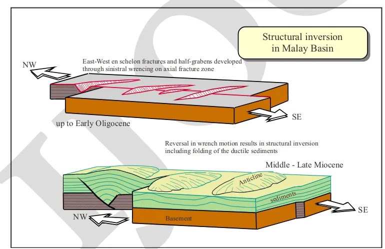
The structural evolution of the central zone of the Malay Basin is diagrammatically shown
in Figure 9. In Oligocene - Early Miocene,
left-lateral transtensional strike-slip faulting occurred on the wide Axial Malay Fault Zone that produced East-West trending pull-aparts. The depressions accommodated deposition of sediments. Slip sense on the AMFZ reverted since the Langhian (Early to Middle Miocene transition) in a transpressional stress regime producing the large East-West
strik-ing anticlines from the pull-apart sediment fillstrik-ings.
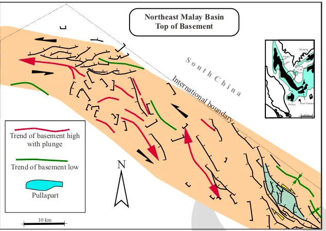
Changing wrench kinematics in the northeast-ern edge of the Malay Basin is illustrated by
Fig-ure 10. The top of basement surface possess folds
IJOG
East-West en schelon fractures and half-grabens developed through sinistral wrencing on axial fracture zone
Reversal in wrench motion results in structural inversion including folding of the ductile sediments
SE NW
Middle - Late Miocene
SE NW
up to Early Oligocene
sediments
Basement
Anticline
Structural inversion in Malay Basin
Figure 9. Diagram shows the development of the AMFZ: initially by sinistral wrenching creating transtensional depressions
(pull-aparts) in systematic pattern, followed by dextral wrench-slip associated with transpression. Southwest
Duyung
Lower Oligocene
Basement
Inversion Mekong
Pattani Malay Nam
Con Son
West Natuna Penyu
200 km 20 km 2
4
5
6
7
8 km
Inversion
Section across southern Malay Basin Structural inversion and compression
Net fault reserval of 550 m at top of Oligocene Unconformity
Middle Miocene
Late OligoceneLower Miocene
Ledeng Pulai Belumut Peta
Northweast
Figure 8. Peta structural inversion has involved over 250 m vertical uplift including basement-involved reverse faulting.
In the southeast, a smaller inverted half graben indicates the tectonic event to have occurred in post-Early Miocene time.
structures associated with left-lateral slip along a curving fault zone trending NW to WNW. A rela-tively small rhombic pull-apart in the southeast of the map correspond to right slip of the wrench zone. Which of the wrench regime was older is
not definitive as age control is wanting. At this
stage of knowledge it is speculated that the initial wrench regime was, probably transpressional,
left lateral sinistral. The rather limited extent of wrench transtensional effect in the Southeast corner was possibly a younger event.
West Natuna Basin
Figure 11 illustrates effects of strong
compres-sion (folds and reverse faults) and at least one
IJOG
S o u t h C
h i na
Northeast Malay Basin Top of Basement
International boundary
Trend of basement high with plunge
Mekong Pattani Malay Nam
Con Son
West Natuna Penyu
200 km
Trend of basement low
Pullapart
N
10 km
Figure 10. Wrench reversal is also demonstrated by structure patterns at basement top at the northeastern ramp of the Malay Basin.
Figure 11. West Natuna Basin at the SE end of the Malay Basin possesses strong compressional structures comprising reverse faults and wrench-slip reversal.
Structures West Natuna Basin Petroconsult (1990)
Mekong Pattani
MalayNamCon Son
West Natuna Penyu
200 km o
105 E
o
7 N
o
6
o
5
o
4 N
o
106 107 Eo
Natuna
K ho
rat S w
ell
MALAY B
ASIN
AR High
Cumi-Cumi Depression
P. Seluan
Kepulauan Anambas
Reverse fault Normal fault Fold axis Strike-slip fault
Boundary Uplift
Gabus Ridge
Arch
Tenggol Arch
Penyu Basin
Natuna 5
IJOG
striking major faults. The Lower Oligocene
graben infill (Belut Formation) up to the Lower
Miocene (Gabus Formation) shows structural
inversion in the form of anticlines (Figure 6;
Daines, 1985).
Malay Basin (2)
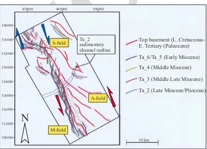
Wrench-slip reversal along the Tenggol Fault along the SW side of the Malay Basin
is illustrated in Figure12 (Shahar, 2008). This
composite fault map at levels representing Oligocene and several horizons of the Miocene shows en echelon faults (red) at the basement top and at the various Miocene levels. The en echelon arrangements are opposed to each other. The red-coloured older fault system represents left wrench slip; all the Miocene levels, and
especially in a well-defined zone of the Tenggol
Fault, indicate later right-lateral wrench slip. Wrench-slip reversals along the Hinge-line fault and its subsidiary Dungun Fault from an initial right-slip to left slip have been documented by pull-aparts whose
sedimen-tary fillings were folded in the subsequent
transpressional stress regime, respectively. Examples were published in Tjia and Liew
(1996), Liew (1996), Tjia (1998), and Petro
-nas (1999) . Figure 13 shows wrench reversal
along a northern segment of the Hinge-line Fault in the Kabut area. Right-lateral wrench-ing (black half-tipped arrows) most likely occurred in the Early-Mid Miocene time span producing a partitioned pull-apart depression.
Middle to Upper Miocene sediments filled
the compartmentalized pull-apart that since the Late Miocene experienced transpressional deformation through wrench-slip reversal (red half-tipped arrows).
Figure 14 shows time structure at ap-proximately pre-Tertiary basement level of the
Dungun Graben and two smaller depressions
along the Dungun Fault, a splay to the west of the Hinge-line Fault (Figure 6). The somewhat streamlined outline of the Dungun Graben suggests an origin as a pull-apart produced by transtensional right-lateral wrenching (black half-tipped arrows). The lower Neogene sedi-mentary graben filling has been folded indicat
-Top basement (L. Cretaceous-E. Tertiary (Paleocene) Ta_6/Ta_5 (Early Miocene) Ta_4 (Middle Miocene)
Ta_3 (Middle Late Miocene) Ta_2 (Late Miocene/Pliocene) S-field
A-field Ta_2 sedimentary channel outline
M-field 470000
532000
528000
524000
520000
516000
512000
508000
480000 490000
540000
536000
10 km
N
Figure 12. A composite fault map of the Tenggol Fault zone highlighting en echelon fault patterns (red coloured associated
with left-lateral wrench slip) and along a narrow zone indicating right wrench-slip in Miocene beds. Shahar (2008) also
IJOG
Figure 13. In the Kabut area on the northern segment of the Hinge-line Fault Zone wrench slip reversal is demonstrated by an earlier right-lateral transtensional stage when the pull-apart was developed, most likely in Early to Middle Miocene when
sediments were filling the depressions. In the succeeding tectonic episode, wrench-slip reversal generated transpression in which the basin-filling deposits were deformed into folds.
Inverted pull-apart depressions
Kabut area (NW Malay Basin)
Depth structure Late Miocene
4300
4300
3800 4100
3900
4100
4000
4200
4200
4200
4000
3800
3900
3700
3500 3600
3700
4400 4500
4500
4500
4600 4700 4800
4800
4900
4900
5000 5000
Mekong Pattani
Malay Nam
Con Son
West Natuna Penyu
200 km
N
well
Hinge-line Fault
ing lateral left-lateral transpressional strike-slip motion (yellow half-tipped arrows), possible since the Middle Miocene.
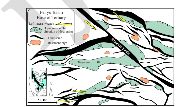
Penyu Basin
At the base of the Tertiary, structures of the
Penyu Basin are shown in Figure 15. The large
half-grabens are up to 4000 m deep and contain the larger portion of the Intra-Oligocene Penyu Formation (Figure 16). The great thickness of
sedimentary basin fill demonstrates a long-last
-ing tensional stress regime. Ngah et al. (1996)
published the Penyu Basin stratigraphy. Other geological information is by Madon and Anuar
(1999). Basement is pre-Oligocene; Penyu For
-mation and the Terengganu Shale are Oligocene;
the Pari Formation is Early-Middle Miocene; the
Pilong Formation includes sediments from Late Miocene to the present. The Rumbia Fault is a prominent fault striking northwest. Subsidiary faults are arranged en echelon implying sinistral wrench slip. The section clearly indicates that the basin experienced two separate episodes of tectonic events. The deep half grabens were asso-ciated with an older pre-Oligocene event. Struc-tural inversion is expressed by the uppermost Oligocene Terengganu Shale. Figures 15 and 16 combined suggest that the wrenching shown by the Rumbia Fault system had been transpressional and represents the younger tectonic event.
Concluding remark on the Hinge-line Fault Zone
ini-IJOG
Figure 15. Near Tertiary base level structures of the Penyu Basin are illustrated. The large half grabens host Oligocene-Quaternary sediments. along Dungun Fault Zone
time contour map (ms) approx. at Pre-Tertiary surcafe
Dungun B
1300 1600 2000 2500
N
IJOG
Malaysia Indonesia
Southwest
Pilong
Pari Inversion Terengganu Shales Inversion
Penyu
Basement Penyu Basin
Northeast
0 35 km 0
1
2
3
4
5
6 km
Figure 16. The Penyu Basin section shows the deep half grabens; inversion distinctly expressed by the Terengganu Shale.
extend offshore to join the Hinge-line fault and faults in the border region of Malaysia-Thailand. At this stage, in both cases age control of their Cenozoic activity is still speculative.
GPS study of coseismic vertical displace-ments associated with the mega-earthquake of the Indian Ocean in 26 December 2004 shows up to 11 mm uplift in the northwest part of Peninsular Malaysia and as much 7 mm for the
region neighbouring Singapore Island (Din et
al., 2012).
Towards the end of the first decade of the
21st century, weak earthquakes (less than 3.8
magnitude) of uncertain origin were recorded in the west-central parts of the Peninsula.
The cited evidences point to crustal distur-bances during the Cenozoic, possibly associ-ated with major faults in Peninsular Malaysia. However, their tectonic association to known
major faults has not been confidently proven.
The present discussion has excluded their possible role until reliable age control can be established.
Strait of Malacca and Northern Sumatra The dominant fault structures in the Strait of Malacca strike North-South. The structural
geology is published in Liew (1995) and Madon
and Ahmad (1999). Liew recognizes four belts
tially transtensional sinistral wrenching that was succeeded by strike-slip reversal, predominantly beginning around Langhian, or transition from Early to Middle Miocene. The reversal was as-sociated with transpression. To the West of the Hinge-line Fault, also referred to as the western ramp of the basin, wrench kinematics progressed in opposite fashion: pre-Langhian dextral transtension succeeded by sinistral wrench slip. Tectonic history interpreted from published evi-dence of the Penyu Basin - located to the west of the Hinge-line Fault- are in general agreement
Peninsular Malaysia
Major strike-slip faults traversing the on-shore area of Peninsular Malaysia have been mapped in some detail. Most of their kinematics appears to have been restricted to the pre-Ter-tiary. The main reason for the lacunae in knowl-edge about their Tertiary tectonic activity is the
paucity of relevant rocks. Two Lower Tertiary
basins, the Batu Arang and Lawin, lie adjacent to the sinistral Kuala Lumpur wrench zone and the similarly sinistral Baubak (also spelled Bok
Bak) wrench fault, respectively (JMG, 1985).
Raj (1998) published a well documented dis
-cussion on tectonic evolution of the Batu Arang Basin. A series of northerly striking fault zones
IJOG
Figure 18. Bengkalis Trough with structures and some hydrocarbon fields exhibiting effects of dextral wrenching of the trough. Simplified from Heidrick and Aulia (1993).
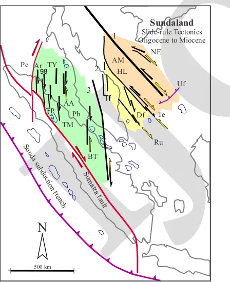
Figure 17. Slide rule tectonics in Sundaland - Major faults: NE (NE Malay Basin), Uf (Udang reverse fault), AM (Axial Malay Fault Zone), HL (Hinge-line Fault Zone), Te Tenggol Fault), Df (Dungun Fault), Ru (Rumbia Fault), Tf (Terengganu faults), BT (Bengkalis Trough), Pb (Pematang Balam zone), AA (Asahan-Aruah zone),
TY (Tamiang-Yang Besar zone), Ar (Arun fault), 98 (98
Fault), TP (Tanjung Pura Fault), TM (Tanjung Morawa Fault), and Pe (Peusangan Fault). Note three wrench-fault
domains have been identified.
Sundaland
of N-S elongated fault depressions bridging
the strait between the coastal zone of Sumatra
into the Malaysian shelf area (Figure 17). Three domains of Cenozoic wrench kinematics are recognized: (1) Malay Basin region, (2) western ramp of the basin, and (3) Strait Malacca zone. Many of the fault depressions are half grabens whose bottom sediments are considered Pema-tang equivalent of Upper Oligocene-Lower Miocene. Strata of the Sihapas equivalent (Middle Miocene) suggest structural inversion in the Central and Southern Grabens, Port Klang Graben, and Johor Graben. Seismic indicates that inversion gradually expires towards the be-ginning of the Pliocene. The graben-bounding, basement- involved faults are associated with
flower structures in the Central, Angsa, Port
Klang, and Johor Grabens. The Bengkalis Trough is drawn in its proper position. Dextral
offsets of Neogene structures are shown in
Figure 18, which is simplified from Heidrick
and Aulia (1993).
Figure 19 is a structural plan of the seismic
basement surface below the Upper Oligocene strata of the Northern Graben. The sigmoidal en echelon pattern of faults indicate the de-pression to have been subjected to right-lateral transtensional wrenching parallel to its longer N-S axis. The transtensional stress environment created the graben as a pull-apart, most likely in the Late Oligocene-Early Miocene time span. The succeeding compressive stress episode of the Mid- to Late Miocene produced structural inversion that appears to have been associated with transtensional wrenching. The
basement-involved flower structures suggest that this may
be the case.
Northerly trending faults in the western margin of Sundaland are below the coastal zone of northern Sumatra. Two regional stress domains relate to the Andaman Basin and Indian Ocean- Australian tectonic entities (Figure 20).
-IJOG
ns -1
CENTRAL GRABEN STRAIT MALACCA
DEPTH > 1 SEC TWT
FAULTS IN BASEMENT
o 99 40' E.
10 km
o 99 35' E. o
05 00' N
N
Figure 19. Systematic en echelon fault pattern in the Tertiary sediments filling the Central Graben of the Aruah-Asahan
deformation zone, Strait of Malacca (AA on Figure 17).
Peusangan F. Andaman Plate
stress regime Arun Fault
98 Fault zone
Kampai Flexure
Indian Ocean - Australian stress regime Northern and Eastern
limit of Lower Miocene and older
Tg. Pura F.
Tg. Morawa F.
Danau Toba
Medan Sum
atra F ault
100 km Pre-Tertiary basement
at 2000 feet depth
Tertiary strike lines
HC fields
2000'
2000'
2000'
N
Figure 20. Northern Sumatra slide-rule tectonics. The area of northern Sumatra from the Peusangan Fault westward is
under the influence of spreading of the Andaman Sea Basin (large arrow shows compression direction). To the East of the
IJOG
Tertiary basement and drag effects on strikes of Tertiary structures is indicated. The distinct dislocation of the Sumatra Fault Zone between
the Peusangan and the 98 Fault from its general
trend was observed earlier (Tjia, 1977).
Discussion and Conclusions
Mainly, Oligocene to Miocene ‘slide-rule’ tectonics are different for three domains of Sundaland (Figure 17). However wrench re-versals appear centered about Langhian (17 to 15.5 Ma; or transition from Early to Mid Miocene). Domain 1 from and including the Hinge-line Fault (HL) eastward was subject to transtension prior to Langhian and wrenching has since reverted to transpression. Wrench ki-nematics had the opposite sequence in Domain 2, that is, westward from the Hinge-line fault and perhaps including major faults in the Malay Peninsula. The paucity of Cenozoic sediments
associated with onshore wrench faults prevents
inclusion of possible wrench kinematics in the discussion. Radiometric dates of 3 mylonites of major onshore wrench faults indicate a latest activity in the later part of the Eocene (Harun,
1992). Weak magnitude seismicity (around 3 and maximum 3.8) in the past decade could not
be satisfactorily related to renewed displacement
along some of the major faults in the western zone of Peninsular Malaysia. For these reasons, Peninsular Malaysia is left out from the current discussion. Cenozoic Domain 3 is bordered by the Bengkalis Trough, the Peusangan Fault, and the active transcurrent Sumatra Fault Zone on the southwest side. Geographically the Beng-kalis Trough extends into the Bentong Suture, but the latter activity during the Cenozoic is not known. Domain 3 contains North-South faults and zones of aligned fault depressions. Wrench-slip reversals were only determined for structures shown in seismic sections.
The Hinge-line Fault distinctly separates two areas of the Malay Basin that have had separate wrench kinematics during the Ceno-zoic: in the main basin area to the east and of the western basin ramp to the west. Figure 1 shows the convergence of the two megaplates
onto Sundaland-Indosinia after the Langhian - Early Miocene to Middle Miocene transi-tion time. Wrench-slip reversals, although not always in tandem, during the Cenozoic history of Sundaland and Indosinia may have had com-mon causes. The Langhian time threshold of change in wrench kinematics (and structural inversions) invites further study. Around the
same geological time, seafloor spreading ceased
in the South China Sea Basin and also in
far-field regions such as the West Philippine and
Caroline Basins.
Acknowledgements
The material and idea for this article were gathered over many years. Inspiration originated from talks with fellow geologists: the late John Ario Katili, G.A.S. Nayoan, C.K. Burton, Khalid Ngah, and Liew Kit Kong.
References
Din, A.H., Omar, K.M., Naeije, M.C., and Ses, S., 2012. Long term sea level change in the Malaysian seas from multi-mission altimetry
data. International Journal of Physical
Sci-ences, 7 (10), p.1694-1712.
CCOP (U.N. Coordinating Committee for
Off-shore Prospecting), 1991. Total sedimentary
isopach maps offshore East Asia (6 maps
with explanatory text). CCOP, Bangkok,
Thailand.
Daines, S.R., 1985. Structural history of the
West Natuna Basin and the tectonic evolution
of the Sunda region. Proceedings Indonesian
Petroleum Association, 14th Annual
Conven-tion, Jakarta, 1, p.39-61.
Fenton, C.H., Charusiri, P., and Wood, S.H., 2003. Recent paleoseismic investigations
in Northern and Western Thailand. Annals
of Geophysics, 46(5), p.957-981.
Harun, Z., 1992. Anatomi sesar-sesar utama
Se-menanjung Malaysia. PhD Thesis,
Univer-siti Kebangsaan Malaysia, 215pp. and maps.
-IJOG
tural and tectonic model of the Central Plain Block, Central Sumatra basin, Indonesia. Proceedings Indonesian Petroleum
Asso-ciation, 22nd Annual Convention, Jakarta,
p.285-317.
JMG (Jabatan Mineral dan Geosains
Malay-sia), 1985. Geological map of Peninsular
Malaysia. Kuala Lumpur, Scale 1:500 000:
2 sheets.
Lacassin, R., Maluski, P., Leloup, P.H., Tap-ponnier, P., Hinthong, C., Siribakdi, K.,
Chuariraj, and Charoenrarat, A., 1997.
Tertiary diachronic extrusion and deforma-tion of western Indochina: structural and
40Ar/39Ar evidence from NW Thailand.
Journal of Geophysical Research, 102 (B5),
p.10013-10037.
Liew, K.K. 1995. Structural patterns within
the Tertiary basement of Strait of Malacca,
Geological Society of Malaysia Bulletin, 38,
p.109-126.
Liew, K.K., 1996. Structural history of Hinge
Fault system of the Malay Basin. Geological
Society of Malaysia Bulletin, 39, p.33-50.
Madon, M. and Ahmad, M., 1996. Chapter 10.
Basin in the Strait of Malacca. In: Leong,
K.M. (ed.), “The petroleum geology and
resources of Malaysia”. Petronas Kuala
Lumpur, p.235-249.
Madon, M. and Anuar, A., 1999. Chapter 9.
Penyu Basin. In: Leong, K.M. (ed.) “The
petroleum geology and resources of
Malay-sia”. Petronas, Kuala Lumpur, p.219-233.
Ngah, K., Madon, M., and Tjia, H.D. 1996.
Role of pre-Tertiary fractures in formation and development of the Malay and Penyu
basins. In: Hall, R. and Blundell, D. (eds.),
“Tectonic evolution of Southeast Asia”, The
Geological Society, Special Publication, 106,
p.281-290.
Petronas, 1999. The petroleum Geology and
resources of Malaysia. Research and
Scien-tific Services and Petroleum Management
Unit, 665 pp.
Raj, J.K., 1998. Tectonic evolution of the Ter
-tiary basin at Batu Arang, Selangor Darul
Ehsan, Peninsular Malaysia. Geological
Society of Malaysia Bulletin, 42, p.197-210.
Rhodes, B.P., Charusiri, P., Kosuwan, S., and Lamjuan, A., 2005. Tertiary evolution of the Three Pagodas Fault, Western Thailand.
In: Wannakao, L., Youngme, W., Srisuk, K.,
and Lertsirivorkul, R. (eds.), Proceedings of
the International Conference on Geology, Geotechnology, and Mineral Resources of
Indochina, Khon Kaen University, Thailand,
p.498-505.
Roques, D., Matthews, S.J., and Rangin,, C.,
1997. Constraints on strike-slip motion from
seismic and gravity data along the Vietnam margin offshore Da Nang: implications for hydrocarbon prospectivity and opening of
the East Vietnam Sea. In: Fraser, A.J.,
Mat-thews, S.J., and Murphy, R.W. (eds.),
Petro-leum Geology of Southeast Asia, Geological
Society London, Special Publication, 126, p.341-353.
Sandal, S.T. (ed.), 1996. The Geology and
Hydrocarbon Resources of Negara Brunei
Darussalam, 1996 revision. Muzium Brunei
Darussalam.
Shahar, S., 2008. Structural evolution of the
Tenggol Arch and its implication for base-ment fracture patterns in the Malay Basin,
Malaysia. Durham University, e-Masters
Thesis, 324pp.
Tapponnier, P., Peltzer, G., le Dain, A.Y., Armijo,
R., and Cobbold, P., 1982. Propagating ex
-trusion tectonics in Asia: new insights from
simple experiments with plasticene.
Geol-ogy, 10, p.611-616.
Taylor, B. and Hayes, D.E., 1983. Origin and
history of the South China Sea Basin. In:
Hayes, D.E. (ed.), The tectonic and geologic
evolution of Southeast Asian seas and is-lands, part 2. American Geophysical Union
Monograph, 27, p.33-56.
Tjia, H.D., 1977. Tectonic depressions along
the transcurrent Sumatra fault zone. Geologi
Indonesia, 4, p.13-27.
Tjia, H.D., 1998. Meridian-parallel faults and
Tertiary basins of Sundaland. Geological
Society of Malaysia Bulletin, 42, p.101-118.
Tjia, H.D. and Liew, K.K., 1996. Changes in tectonic stress field in northern Sunda Shelf
IJOG
Tectonic evolution of Southeast Asia, The
Geological Society, Special Publication, 106,
p.291-306.
Wongsosantiko, A. and Wirojudo, G.K., 1984.
Tertiary tectonic evolution and related
hydro-carbon potential in the Natuna area.
Proceed-ings of Indonesian Petroleum Association, 13th
Annual Convention, p.161-183.
Zuchiewicz, W. and Cuong, N.Q., 2009. Quater
-nary tectonics of the Red River Fault Zone in Vietnam - A morphotectonic approach.