DETERMINATION OF NUCLEAR POWER
PLANT SITE IN WEST BANGKA BASED ON
ROCK MASS RATING AND GEOLOGICAL
STRENGTH INDEX
Irvani*, Wahyu Wilopo, and Dwikorita Karnawati
Department of Geological Engineering, Gadjah Mada University, Yogyakarta, Indonesia
Abstract
Indonesian government through the National Atomic Energy Agency has planned to build a nuclear power plant. One of the proposed sites is in West Bangka Regency, Bangka Belitung Archipelago Province. The engineering geology of this area is, however, not fully understood and requires further investigations. Engineering geol-ogy investigations were carried out by assessing the rock mass quality and bearing capacity based on field observation and drilling data. The assessment was conducted using Rock Mass Rating (RMR) and Geological Strength Index (GSI) classifications. The rock masses in the study area were divided into four units, namely units of sandstone, granite, mudstone and pebbly sandstone. The RMR and GSI values in the study area were influenced by the parameters of discontinuity space density, the slope of discontinuity orientation, grade of weathering and groundwater conditions. The assessment shows that the granite unit had the best quality which was shown by a 53 average RMR value and 66 GSI value. Based on the average RMR value, the granite unit was estimated to have cohesion value between 0.2 and 0.3 MPa, friction angle between 25° and 35°, and allowable bearing pressure between 280 and 135 T/m2. Based on the GSI value, the granite unit was estimated to have uniaxial compressive strength value between 1.0465 and 183.8 MPa,
ten-*Corresponding author: IRVANI, Department of Geo-logical Engineering, Gadjah Mada University. Jl. Grafika 2 Yogyakarta, Indonesia. E-mail: [email protected]
sile strength between (-0.0122) and (-5.2625) MPa, rock mass strength values between 24.5244 and 220.351 MPa, and modulus of deformation within a range of 1.73 - 86.68 GPa. The Granite Unit was considered to be the most appropriate location for the nuclear power plants.
Keywords: nuclear power plant foundation, Geo-logical Strength Index, Rock Mass Rating, rock mass quality
1 Introduction
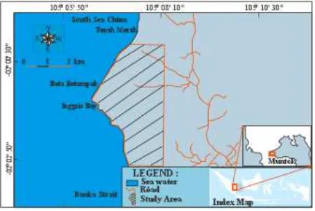
Construction of Nuclear Power Plant is a way to overcome the limitation of electrical energy in Indonesia. A feasibility study of nuclear power plant site was conducted in Muntok Dis-trict, West Bangka Regency, Bangka Belitung Archipelago Province (Figure 1). The feasibility study invloved comprehensive investigation of the rock mechanical properties.
Figure 1: Study area map.
Wyllie and Mah (2004) and Giani (1992) state that rock material experienced a collapse as the rock mass. Rocks mass consists of blocks of rock and discontinuities as a union (Palmstrom, 1995). Each type of rock has different char-acter and mechanics ability (Goodman, 1989). Analyses of rock mechanics require a model and geological data based on rock type, dis-continuities structure and material properties (Hoek, 2007). Geological data collection stages are reference study, reconnaissance, drilling ex-ploration, trenching and pitting, in situ testing, detail testing and mapping (Cheng and Lau, 2008). A comprehensive investigation of rock discontinuities is described in detail in Wyllie (1999).
This study aims to evaluate the rock mass quality for estimating the bearing capacity and determination of the best location of the shal-low foundation of a nuclear power plant us-ingthe Rock Mass Rating (RMR) (Bieniawski, 1989) and Geological Strength Index (GSI) Clas-sifications (Hoek, 1994).
2 Research Methods
This study was conducted by determining the Rock Mass Rating (RMR) (Bieniawski, 1989) and the Geological Strength Index (GSI) Meth-ods (Hoek, 1994), from outcrop and drill core data. Uniaxial compressive strength (UCS) of rock samples were obtained from rebound values conversion of digital Schmidt hammer type N using Kilic and Teymen equation (Kilic and Teymen, 2008), while the adjustment value
3 Results and Discussion
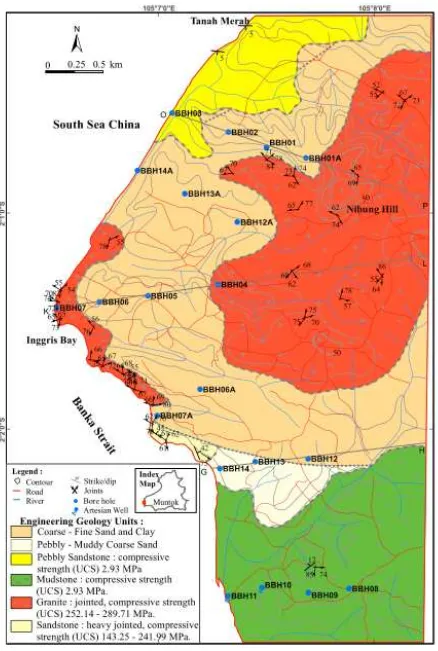
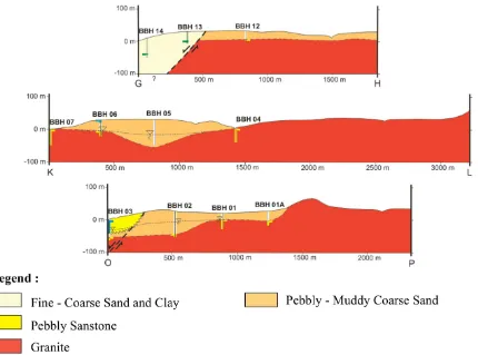
Detailed geological conditions of the study area have been described by Irvani et al. (2013) and Irvani (2013). Geomorphological units in the study area were flat, gently sloping, slop-ing, and moderately steep hill geomorphology units. The lithologies from the youngest to the oldest were Triassic sandstone, Late Trias-sic - JuraTrias-sic granite, Late Miocene - Pleistocene mudstone and pebbly sandstone
3.1 Discontinuity orientation
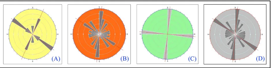
Stereographic analyses using a Dips v.5.1 soft-ware were performed to determine the relative orientation of discontinuities in each rock unit (Figure 2), except the pebbly sandstone unit. Rose diagrams shown in Figure 2 indicate that the sandstone unit has a major northwest-southeast (N 305◦E) and northeast-southwest (N 25◦E) principle orientations, the granite unit has a north-south (N 05◦E) and northwest-southeast (N 305◦E) principle orientations, whereas the mudstone unit has north-south (N 05◦E) and east-west (N 275◦E) principle ori-entations. In general, the relative orientations of the rock discontinuities were northwest-southeast and north-south. The faults in the study area were estimated to be old inactive faults.
3.2 Engineering geology of the study area
Figure 2: Principle Discontinuity orientation: (A) Sandstone, (B) Granite, (C) Mudstone, (D) All unit of rock .
rebound value, had UCS ranging from 143.25 to 241.99 MPa. The granite unit occupied an area of 393 hectares was crystalline, fresh – mod-erately weathered, very compact, jointed, and had UCS between 252.14 and 289.71 MPa. Mud-stone unit occupied an area of 236.2 hectares and pebbly sandstone unit occupied an area of 87 hectares were moderately weathered, un-compacted well, and had a 2.93 MPa UCS. The pebbly – muddy coarse sand unit occupied an area of 469 hectares and the fine – coarse sand unit occupied an area of 41.8 hectares covered the granite and sandstone units, had a thickness of a few meters to over 80 meters, wascompact to slightly loose , and estimated as the result of rock weathering and alteration.
3.3 Rock mass quality classification based on RMR
Observations of 30 surface data and 20 drilling points were conducted for the rock mass qual-ity evaluation. The engineering geological map was used to determine the distribution, depth and boundary of the RMR.
The sandstone unit has limited surface data in 3 observation stations. The basic RMR value was 53.75–62 andcorrected RMR was 31.25–42 that indicate poor to medium quality. The sub-surface data of sandstones recorded at BBH 13 and BBH 14 drilling points were weathered and altered, present in considerable depth and are not dominant part of the sandstone unit The sandstone unit had basic RMR values from 36.26 to 37.25 and corrected RMR values from 25.25–26.26 indicating poor quality. The rock mass quality state is affected by space
den-sity and slope orientation of discontinuities, the presence of filling, degree of weathering or al-teration, as well groundwater condition.
Granite Unit has a very poor – very good quality, with moderate quality in general. Sur-face data about 24 stations observation has ba-sic RMR between 62.33–100, corrected RMR is 41.33 - 100, has been moderate – very good quality, with moderate quality in general. Sub-surface data (drilling point of BBH 01, BBH 01A, BBH 02, BBH 03, BBH 04, BBH 06, BBH 06A, BBH 07, BBH07A, BBH 12, BBH 12A and BBH 14A) have the basic RMR between 29– 87, corrected RMR is 4–77, and has very poor – good quality, with moderate general quality. The rock quality is influenced by density space and orientation of discontinuities, weathering, filling, as well groundwater condition, where the quality of surface data tends better than the subsurface data, because it has less space and fresh rock condition, as well above the ground-water table.
3.4 Rock mass quality based on RMR classi-fication
Based on the RMR value of rock mass, Granite and Pebbly Sandstone Unit with moderate gen-eral quality of rock mass was having estimated the range values of cohesion is 0.2–0.3 MPa, the internal friction angle between 25–35◦, and the allowable bearing pressure is 280–135 T/m2. Both of Sandstone and Mudstone Units have poor rock mass quality, has estimated value of cohesion between 0.1–0.2 MPa, internal friction angle value is 15–25◦, and estimated allowable bearing pressure between 135–45 T/m2.
3.5 Rock mass quality and capacity based on geological strength index (GSI) classifi-cation
Rock mass GSI quality evaluation and its capac-ity have been discussed in detail in Irvaniet al. (2013) and Irvani (2013). Variety and the best quality are owned by Granite Unit (GSI = 27– 95) with good general quality, whereas for the Sandstone Unit (GSI = 44–55), Mudstone Unit (GSI = 39–43) and Pebbly Sandstone Unit (GSI = 42) all being moderate quality.
The result of rock capacity calculation shows the variation of value and high capacity at Granite Unit. Granite Unit has compressive strength (UCS) between 1.0465–183.8 MPa, ten-sile strength in a range (-0.0122) – (-5.2625) MPa, the rock mass strength between 24.5244– 220.351 MPa, as well variations of modulus de-formation between 1.73–86.68 GPa with an av-erage high value. Sandstone Unit has com-pressive strength (UCS) between 2.3079–7.7621 MPa, tensile strength range (-0.2131) – (-0.0546) MPa, the rock mass strength between 16.3223– 33.1094 MPa, and the large of deformation
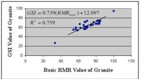
Figure 5: Linear relationship of basic RMR and GSI value of Granite Unit.
modulus between 4.60–8.67 GPa. Mudstone Unit has compressive strength (UCS) is 0.0317 MPa, tensile strength is -0.003 MPa, the rock mass strength is 0.1373 MPa, and modulus of deformation is 3.45 GPa. Pebbly Sandstone Unit has compressive strength (UCS) is 0.0403 MPa, tensile strength is -0.0009 MPa, the rock mass strength is 0.3135 Mpa, and modulus of deformation is 4.1 GPa.
3.6 Relationship between RMR and GSI classification
The limited amount of available data, especially for the surface data (outcrop) on Unit Sand-stone, Mudstone and Pebbly Sandstone caused the results of analysis of the relationship be-tween value of basic RMR and GSI on the third unit is not significant, significant results only showed by Granite Unit because it has rich amount of measurements data. Linear relation-ship basic RMR and GSI Granite Unit with re-gression factor is 0.759, indicating a strong rela-tionship and it was formulated by the equation GSI = 0.739 (RMRbasic) + 12.097 as illustrated by Figure 5.
3.7 The best location for nuclear power plant site
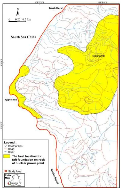
weathered rock or soil layers up to tens meters like at BBH 02, BBH 05, BBH 12A, and 13A BBH drilling points. Rock quality assessment based on RMR method uses adjustment value of dis-continuity orientation for raft foundation type, so that a thick layer of soil and weathered rock become constraints in determining the location of nuclear power plants site. Granite Unit with an area about 393 Hectares is the suitable loca-tion for shallow foundaloca-tion of nuclear power plants as in Figure 6, this is in line with the opin-ion that raised by Irvaniet al. (2013) and Irvani (2013).
4 Conclusion
In general, the RMR in the study area was tween poor and moderate, and the GSI was be-tween poor and good. Granite unit had the best quality from all lithological units. Granite unit was distributed over 393 Ha with a mod-erate RMR and a good GSI . Factors affecting the granite unit quality was the spacing den-sity of discontinuity, filling, weathering, discon-tinuity orientation with respect to large slope, and groundwater flow conditions for subsur-face data.
Based on the quality and bearing capacity evaluation of the rock mass using RMR and GSI classifications, the Granite unit was con-sidered to be the most appropriate location for the placement of nuclear power plants with the raft foundation type. Based on the RMR and GSI, the estimated cohesion value of the Gran-ite unit was 0.2–0.3 MPa, the internal friction angle was between 25◦and 35◦, allowable bear-ing pressure wass between 280 and 135 T/m2, compressive strength was between 1.0465 and 183.8 MPa, tensile strength was between -5.2625 and 0.0122 MPa, the rock mass strength was be-tween 24.5244 and 220.351 MPa, and the large of deformation modulus was between 1.73 and 86.68 GPa.
References
Barber, A.J., Crow, M.J. and Milsom, J.S. (2005) Sumatra: Geology, Resources and Tectonic
Evolution. Geological Society Memoir, No. 31.
Bieniawski, Z.T. (1989) Engineering Rock Mass Classification, Mining and Mineral Resources Research Institute, Pennsylvania State Uni-versity.
Cheng, Y.M. and Lau, C.K. (2008) Slope Sta-bility Analysis and Stabilization: New Meth-ods and Insight. Routledge. London & New York.
Giani, G.P. (1992) Rock Slope Stability Anal-ysis, A.A. Balkema Publishers, Rotterdam, Netherlands.
Goodman, R.E. (1989) Introduction to Rock Me-chanics. 2nd Edition, John Wiley & Sons, Canada.
Hoek, E. (1994) Strength of Rock and Rock Masses, News J ISRM 2 (2):4-16.
Hoek, E. (2007) Practical Rock Engineering, Notes, Evert Hoek Consulting Engineer Inc., Canada.
Hoek, E., Carranza-Torres, C. and Corkum, B. (2002) Hoek-Brown Failure Criterion-2002 Edition, Proc. NARMS-TAC Conf., Toronto, Vol. 1, p. 267-273.
Irvani (2013) Rock Mass Quality Evaluation at The Nuclear Power Plant Site Using Rock Mass Rating and Geological Strength Index Methods, in Bangka Barat Regency, Bangka Belitung Archipelago Province. Master The-sis, Gadjah Mada University, Yogyakarta. Irvani., Wilopo, W., dan Karnawati, D. (2013)
Evaluasi Kualitas Massa Batuan Pada Lokasi Tapak PLTN Menggunakan Metode Geolog-ical Strength Index, di Kabupaten Bangka Barat, Propinsi Kepulauan Bangka Belitung. Proceeding Seminar Nasional, Teknik Ge-ologi, Universitas Gadjah Mada, Yogyakarta. IS 12070 (1987) Indian standard code of practice for design and construction of shallow foun-dations on rocks. New Delhi: Bureau of In-dian Standards.
Kilic, A. and Teymen, A. (2008) Determination of Mechanical Properties of Rocks Using Sim-ple Methods, Bull Eng Geol Env., Vol. 67, p. 237-244.
Penelitian dan Pengembangan Geologi, Ban-dung.
Margono, U., Supandjono, R.J.B. dan Partoyo, E. (1995) Peta Geologi Lembar Bangka Sela-tan, Sumatra. Pusat Penelitian dan Pengem-bangan Geologi, Bandung.
Palmstrom, A. (1995) RMi - A Rock Mass Char-acterization System for Rock Engineering Purposes. Thesis (PhD), Oslo University, Norwegia.
Singh, B. and Goel, R.K. (2011) Engineer-ing Rock Mass Classification: Tunneling, Foundation, and Landslides, Butterworth-Heinemann, Elsevier Inc., USA, 2011.
Van Bemmelen, R.W. (1970) The Geology of In-donesia, General Geology Volume I A. Mart-inus Nighoff, The Hague, Netherland. Van Gorsel, J.T. (2012) Sundaland: Bibliography
of The Geology of Indonesia and Surround-ing Areas, Edition 4.1., Bibliography of In-donesian Geology.
Wyllie, D.C. (1999) Foundations on Rock, 2nd Edition, E & FN Spon, London, 1999.