Open Geospatial Consortium
Approval Date:
2013-01-18
Posted Date:
2013-02-05
Reference number of this document:
OGC 12-093
Reference URN for this document: http://www.opengis.net/def/doc-type/per/ows9-ssi-ugas
Category:
Engineering Report
Editor:
Clemens Portele
OGC
®
OWS-9 System Security Interoperability (SSI)
UML-to-GML-Application-Schema (UGAS) Conversion Engineering
Report
Copyright © 2013 Open Geospatial Consortium.
To obtain additional rights of use, visit http://www.opengeospatial.org/legal/.
Warning
This document is not an OGC Standard. This document is an OGC Public
Engineering Report created as a deliverable in an OGC Interoperability Initiative
and is not an official position of the OGC membership. It is distributed for review
and comment. It is subject to change without notice and may not be referred to as
an OGC Standard. Further, any OGC Engineering Report should not be referenced
as required or mandatory technology in procurements
.
Document type:
OGC
®Engineering Report
Document subtype:
NA
Document stage:
Approved for public release
Abstract
The main scope of the schema automation activities in the OWS-9 initiative was twofold:
Support for the SWE Common 2.0 XML Schema encoding rule
Development of and support for an encoding rule for JSON instance data
In both cases the scope includes implementation of the encoding rules in ShapeChange.
In addition, an initial analysis of the possibilities for generating SWE Common 2.0 record
descriptions from schemas in UML has been conducted and the results are described in
this document.
The approach and results to both work items are described and discussed in this
engineering report. This Engineering Report has been prepared as part of the OGC Web
Services Phase 9 (OWS-9) initiative.
Keywords
ogcdoc, ows9, ssi, ugas, json, swe common, uml, 19109, geojson, gml, geoservices rest
api
What is OGC Web Services 9 (OWS-9)?
OWS-9 builds on the outcomes of prior OGC interoperability initiatives and is organized
around the following threads:
-
Aviation
: Develop and demonstrate the use of the Aeronautical Information Exchange
Model (AIXM) and the Weather Exchange Model (WXXM) in an OGC Web Services
environment, focusing on support for several Single European Sky ATM Research
(SESAR) project requirements as well as FAA (US Federal Aviation Administration)
Aeronautical Information Management (AIM) and Aircraft Access to SWIM (System
Wide Information Management) (AAtS) requirements.
-
Cross-Community Interoperability (CCI)
: Build on the CCI work accomplished in
OWS–8 by increasing interoperability within communities sharing geospatial data,
focusing on semantic mediation, query results delivery, data provenance and quality and
Single Point of Entry Global Gazetteer.
-
Security and Services Interoperability (SSI)
: Investigate 5 main activities: Security
Management, OGC Geography Markup Language (GML) Encoding Standard
-
OWS Innovations
: Explore topics that represent either new areas of work for the
Consortium (such as GPS and Mobile Applications), a desire for new approaches to
existing technologies to solve new challenges (such as the OGC Web Coverage Service
(WCS) work), or some combination of the two.
-
Compliance & Interoperability Testing & Evaluation (CITE)
: Develop a suite of
compliance test scripts for testing and validation of products with interfaces
implementing the following OGC standards: Web Map Service (WMS) 1.3 Interface
Standard, Web Feature Service (WFS) 2.0 Interface Standard, Geography Markup
Language (GML) 3.2.1 Encoding Standard, OWS Context 1.0 (candidate encoding
standard), Sensor Web Enablement (SWE) standards, Web Coverage Service for Earth
Observation (WCS-EO) 1.0 Interface Standard, and TEAM (Test, Evaluation, And
Measurement) Engine Capabilities.
License Agreement
Permission is hereby granted by the Open Geospatial Consortium, ("Licensor"), free of charge and subject to the terms set forth below, to any person obtaining a copy of this Intellectual Property and any associated documentation, to deal in the Intellectual Property without restriction (except as set forth below), including without limitation the rights to implement, use, copy, modify, merge, publish, distribute, and/or sublicense copies of the Intellectual Property, and to permit persons to whom the Intellectual Property is furnished to do so, provided that all copyright notices on the intellectual property are retained intact and that each person to whom the Intellectual Property is furnished agrees to the terms of this Agreement.
If you modify the Intellectual Property, all copies of the modified Intellectual Property must include, in addition to the above copyright notice, a notice that the Intellectual Property includes modifications that have not been approved or adopted by LICENSOR. THIS LICENSE IS A COPYRIGHT LICENSE ONLY, AND DOES NOT CONVEY ANY RIGHTS UNDER ANY PATENTS THAT MAY BE IN FORCE ANYWHERE IN THE WORLD.
THE INTELLECTUAL PROPERTY IS PROVIDED "AS IS", WITHOUT WARRANTY OF ANY KIND, EXPRESS OR IMPLIED, INCLUDING BUT NOT LIMITED TO THE WARRANTIES OF MERCHANTABILITY, FITNESS FOR A PARTICULAR PURPOSE, AND NONINFRINGEMENT OF THIRD PARTY RIGHTS. THE COPYRIGHT HOLDER OR HOLDERS INCLUDED IN THIS NOTICE DO NOT WARRANT THAT THE FUNCTIONS CONTAINED IN THE INTELLECTUAL PROPERTY WILL MEET YOUR REQUIREMENTS OR THAT THE OPERATION OF THE INTELLECTUAL PROPERTY WILL BE
UNINTERRUPTED OR ERROR FREE. ANY USE OF THE INTELLECTUAL PROPERTY SHALL BE MADE ENTIRELY AT THE USER’S OWN RISK. IN NO EVENT SHALL THE COPYRIGHT HOLDER OR ANY CONTRIBUTOR OF
INTELLECTUAL PROPERTY RIGHTS TO THE INTELLECTUAL PROPERTY BE LIABLE FOR ANY CLAIM, OR ANY DIRECT, SPECIAL, INDIRECT OR CONSEQUENTIAL DAMAGES, OR ANY DAMAGES WHATSOEVER RESULTING FROM ANY ALLEGED INFRINGEMENT OR ANY LOSS OF USE, DATA OR PROFITS, WHETHER IN AN ACTION OF CONTRACT, NEGLIGENCE OR UNDER ANY OTHER LEGAL THEORY, ARISING OUT OF OR IN CONNECTION WITH THE IMPLEMENTATION, USE, COMMERCIALIZATION OR PERFORMANCE OF THIS INTELLECTUAL PROPERTY. This license is effective until terminated. You may terminate it at any time by destroying the Intellectual Property together with all copies in any form. The license will also terminate if you fail to comply with any term or condition of this Agreement. Except as provided in the following sentence, no such termination of this license shall require the termination of any third party end-user sublicense to the Intellectual Property which is in force as of the date of notice of such termination. In addition, should the Intellectual Property, or the operation of the Intellectual Property, infringe, or in LICENSOR’s sole opinion be likely to infringe, any patent, copyright, trademark or other right of a third party, you agree that LICENSOR, in its sole discretion, may terminate this license without any compensation or liability to you, your licensees or any other party. You agree upon termination of any kind to destroy or cause to be destroyed the Intellectual Property together with all copies in any form, whether held by you or by any third party. Except as contained in this notice, the name of LICENSOR or of any other holder of a copyright in all or part of the Intellectual Property shall not be used in advertising or otherwise to promote the sale, use or other dealings in this Intellectual Property without prior written authorization of LICENSOR or such copyright holder. LICENSOR is and shall at all times be the sole entity that may authorize you or any third party to use certification marks, trademarks or other special designations to indicate compliance with any LICENSOR standards or specifications.
This Agreement is governed by the laws of the Commonwealth of Massachusetts. The application to this Agreement of the United Nations Convention on Contracts for the International Sale of Goods is hereby expressly excluded. In the event any provision of this Agreement shall be deemed unenforceable, void or invalid, such provision shall be modified so as to make it valid and enforceable, and as so modified the entire Agreement shall remain in full force and effect. No decision, action or inaction by LICENSOR shall be construed to be a waiver of any rights or remedies available to it.
Contents
Page
1
Introduction ... 1
1.1
Scope ... 1
1.2
Document contributor contact points ... 1
1.3
Revision history ... 1
1.4
Future work ... 2
1.5
Forward ... 2
2
References ... 2
3
Terms and definitions ... 3
4
Conventions ... 3
4.1
UML notation ... 3
5
Schema automation in OWS-9 overview ... 3
6
Support for JSON ... 4
6.1
Overview ... 4
6.2
Analysis ... 6
6.2.1
Overview ... 6
6.2.2
The general approach ... 6
6.2.3
More complex instances ... 12
6.2.3.1
Properties with a maximum multiplicity greater than 1 ... 12
6.2.3.2
Properties with values that are data types ... 13
6.2.3.3
Properties that allow nil values and metadata on those nil values ... 13
6.2.3.4
Properties with values that are enumerants ... 14
6.2.3.5
Properties with values that are code list values ... 14
6.2.3.6
Properties with values that are of types Date, Time or DateTime ... 15
6.2.3.7
Properties with values that are of type Measure or any of its subtypes ... 15
6.2.3.8
String properties with regular expression patterns ... 16
6.2.3.9
Properties with values that are features/objects ... 16
6.2.3.10
Multiple geometry properties per feature ... 17
6.2.3.11
Types without geometry properties ... 18
6.2.3.12
Support for ISO 19100 types used in application schemas ... 18
6.3
Implementation and test application schema ... 18
6.3.1
Implementation in ShapeChange ... 18
6.3.2
The test application schema ... 19
6.3.3
Simple GeoServices JSON encoding rule ... 19
6.3.4
Extended GeoServices JSON encoding rule ... 24
6.4
Examples ... 30
6.4.1
TDS ... 30
6.4.2
WXXM ... 38
6.5
Results and recommendations ... 39
6.6.1
Encoding requirements ... 39
6.6.2
Conversion rules ... 41
6.6.2.1
UML package with stereotype <<applicationSchema>> ... 41
6.6.2.2
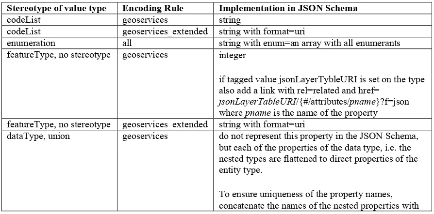
UML classifier with stereotype <<featureType>> or no stereotype ... 41
6.6.2.3
UML classifier with stereotype <<dataType>> or <<union>> ... 42
6.6.2.4
UML classifier with stereotype <<enumeration>> or <<codeList>> ... 43
6.6.2.5
UML classifier with other stereotypes ... 43
6.6.2.6
UML properties ... 43
6.6.2.7
OCL constraints ... 44
6.6.2.8
Documentation ... 44
7
SWE Common support ... 44
7.1
Background ... 44
7.2
SWE Common 2.0 Encoding Rule ... 45
7.2.1
The Encoding Rule ... 45
7.2.2
Test Model ... 47
7.3
Related topics ... 48
7.3.1
Overview ... 48
7.3.2
Use of SWE Common data components in ISO 19115-based metadata ... 48
7.3.3
UML Templates for SWE Data Streams and Data Records ... 49
7.3.3.1
Scope ... 49
7.3.3.2
UML Profile and Mapping ... 49
7.4
Results and recommendations ... 54
Figures
Page
Figure 1 – Converting an application schema to implementation schemas ... 5
Figure 2 – Accessing the same dataset in JSON and GML representations ... 6
Figure 3 - Test application schema ... 19
Figure 4 - ArcGIS.com Map Viewer accessing selected feature types of the TDS dataset
(JSON) ... 30
Figure 5 – Popup showing some of the attributes of a BuidingGeosurface feature (JSON) . 31
Figure 6 – Gaia accessing selected feature types of the TDS dataset (GML) ... 31
Figure 7 – Additional window showing some of the attributes of a BuidingGeosurface
feature (GML) ... 32
Figure 8 - MSNCC-EPOCHA Data Stream ... 51
OGC
®
OWS-9 System Security Interoperability
(SSI)
UML-to-GML-Application-Schema (UGAS) Conversion Engineering
Report
1
Introduction
1.1
Scope
The main scope of the schema automation activities in the OWS-9 initiative is twofold:
Support for the SWE Common 2.0 XML Schema encoding rule
Development of and support for an encoding rule for JSON instance data
In both cases the scope includes implementation of the encoding rules in ShapeChange.
In addition, an initial analysis of the possibilities for generating SWE Common 2.0 record
descriptions from schemas in UML has been conducted and the results are described in
this document.
The approach and results to both work items are described and discussed in this
engineering report.
1.2
Document contributor contact points
All questions regarding this document should be directed to the editor or the contributors:
Name
Organization
Clemens Portele (Editor)
interactive instruments GmbH
Paul Birkel
Mitre
Ellen Badgley
Mitre
1.3
Revision history
Date
Release
Editor
Primary clauses
modified
Description
2012/07/23 0.1
C. Portele All
Initial document template and contents
2012/11/04 0.2
C. Portele 7
Text for SWE Common added
2012/12/09 0.3
C. Portele 1, 5, 6
Text for JSON Encoding Rule added
2012/12/20 0.4
C. Portele All
Updates based on comments/review by Ellen
1.4
Future work
Improvements in this document are desirable
by testing and analyzing the use of JSON data encoded according to the encoding
rule in more depth
in particular by improving the GeoServices JSON encoding rule, e.g. by using
domains and aliases as tested in the demo service
by developing a JSON schema for GeoJSON and extending the JSON Schema
encoding rules with GeoJSON options
by testing potential extensions of the GeoServices JSON encoding, e.g. for
including hyperlinks
by testing and analyzing in more depth, if UML can be useful to model templates
for SWE Common data components
In a future revision of the SWE Common Data Model, the incorrect statement that “all
elements are substitutable for gml:AbstractValue (and thus transitively for
gml:AbstractObject) so that they can be used directly by GML application schemas”
should be removed. In such a revision it could also be considered, if the SWE Common
encoding rule (see 7.2) should be included in the standard.
1.5
Forward
Attention is drawn to the possibility that some of the elements of this document may be
the subject of patent rights. The Open Geospatial Consortium shall not be held
responsible for identifying any or all such patent rights.
Recipients of this document are requested to submit, with their comments, notification of
any relevant patent claims or other intellectual property rights of which they may be
aware that might be infringed by any implementation of the standard set forth in this
document, and to provide supporting documentation.
2
References
The following documents are referenced in this document. For dated references,
subsequent amendments to, or revisions of, any of these publications do not apply. For
undated references, the latest edition of the normative document referred to applies.
JSON Schema, IETF Draft 3, http://tools.ietf.org/html/draft-zyp-json-schema-03
OGC Geography Markup Language, Version 3.2, Open Geospatial Consortium (OGC)
OGC Geography Markup Language, Version 3.3, Open Geospatial Consortium (OGC)
GeoServices REST API – Part 1: Core, RFC Version, Open Geospatial Consortium
(OGC)
GeoJSON, Version 1.0, http://geojson.org/geojson-spec.html
3
Terms and definitions
For the purposes of this report, the definitions specified in Clause 4 of the OWS Common
Implementation Standard [OGC 06-121r3] and in the normative references shall apply.
4
Conventions
GML Geography Markup Language
ISO
International Organization for Standardization
JSON JavaScript Object Notation
OGC
Open Geospatial Consortium
OWS OGC Web Services
UGAS UML-to-GML-Application-Schema conversion
UML Unified Modeling Language
XML eXtended Markup Language
4.1
UML notation
Diagrams that appear in this standard are presented using the Unified Modeling Language
(UML) static structure diagram, as described in ISO/TS 19103.
5
Schema automation in OWS-9 overview
UML is frequently used to specify and maintain conceptual schemas for geographic
information. In order to derive implementation schemas from these conceptual schemas
in order to use them in the communication between systems or as a basis for
implementations in software, rules are needed to help automate these processes. Tools
can then be built that implement these rules and support building solutions based on the
conceptual schemas.
ShapeChange is such a tool that takes application schemas for geographic information
and converts them into a variety of target representations including GML application
schemas, XML schemas according to ISO/TS 19139, feature catalogues, code list
dictionaries, etc. More information about ShapeChange is available at
The schema automation activities in the OWS-9 initiative
have specified and implemented an encoding rule for JSON (see Clause 6).
have clarified and implemented the SWE Common 2.0 XML Schema encoding rule
(see 7.2),
have analyzed possibilities for generating SWE Common 2.0 record descriptions
from schemas in UML (see 7.3).
6
Support for JSON
6.1
Overview
The scope of the activity discussed in this Clause is to explore the generation of JSON
Schema – or alternative means – for specifying JSON-based data exchange structures
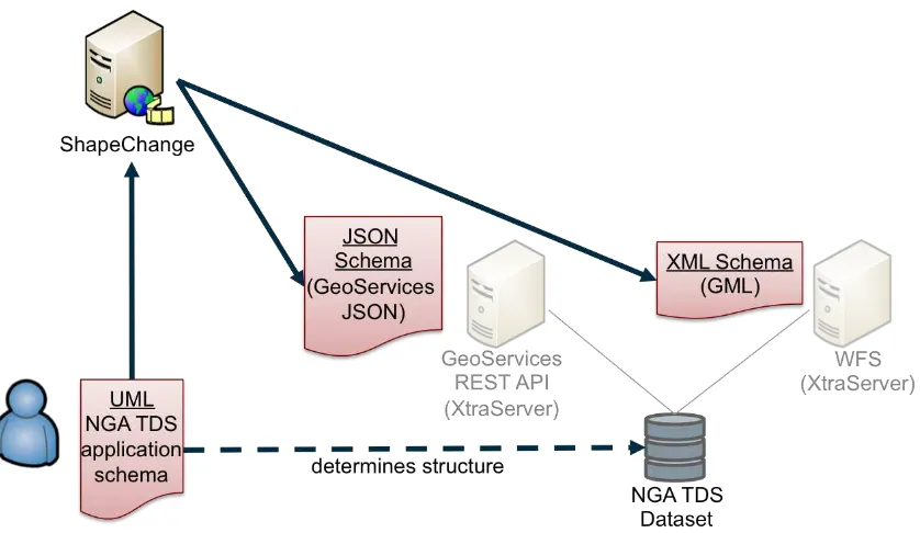
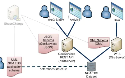
from UML similar to the UGAS approach.
Figure 1 illustrates the conversion process. An organisation, in this example NGA,
manages an application schema according to ISO 19109, in this example NGA TDS. This
application schema determines the structures in which data is captured and stored as
datasets in spatial databases.
ShapeChange is used to derive representations from the application schema. In this case
the XML Schema (a GML application schema) and JSON Schema (consistent with the
GeoServices JSON feature model) representations are shown. The process has been used
for GML application schemas for many years now. The GML application schemas will
then typically be used to publish the data via an OGC Web Feature Service.
Figure 1 – Converting an application schema to implementation schemas
Figure 2 – Accessing the same dataset in JSON and GML representations
This already shows one option for representing the data in JSON. Other options are
explored in the next sections.
6.2
Analysis
6.2.1
Overview
This sub-clause analyzes different options, documents the decisions and provides a
rationale for the decisions.
6.2.2
The general approach
We have considered three basic options for encoding features in JSON, that will be
discussed in more detail below.
1.
Use the feature and geometry encoding of the GeoServices JSON encoding
specified by the GeoServices REST API. The GeoServices REST API is currently
is candidate OGC standard.
2.
Use the feature and geometry encoding of the GeoJSON encoding.
As a basis for a decision on the general approach, a simple BuildingGeopoint feature
from the Monterey data set used in OWS-9 is used to analyze at the different options. The
feature encoded in GML is shown below:
<tds:BuildingGeopoint gml:id="StructurePoints8"
xmlns:tds="http://metadata.dod.mil/mdr/ns/GSIP/3.0/tds/3.0" xmlns:gml="http://www.opengis.net/gml/3.2">
<tds:geometry>
<gml:Point gml:id="StructurePoints8.Geom_0"
srsName="http://metadata.ces.mil/mdr/ns/GSIP/crs/WGS84E_2D"> <gml:pos>36.732821045 -121.633961892</gml:pos>
</gml:Point> </tds:geometry>
<tds:address>No Information</tds:address>
<tds:aeroObstacleLightPresent>false</tds:aeroObstacleLightPresent> <tds:note.memorandum>No Information</tds:note.memorandum> <tds:religiousInfo.religiousDesignation>noInformation
<tds:specifiedEnumerants>No Information</tds:specifiedEnumerants> <tds:uniqueEntityIdentifier>No Information</tds:uniqueEntityIdentifier> <tds:verticalConstMaterial-1>noInformation</tds:verticalConstMaterial-1> <tds:verticalConstMaterial-2>noInformation</tds:verticalConstMaterial-2> <tds:verticalConstMaterial-3>noInformation</tds:verticalConstMaterial-3> <tds:verticalObstIdentifier>No Information</tds:verticalObstIdentifier> <tds:width>19.29426795</tds:width>
</tds:BuildingGeopoint>
A straightforward mapping to GeoServices JSON of this feature would be:
{
"address":"No Information",
"aeroObstacleLightPresent":"false", "angleOfOrientation":115.00000000, "area":568.99756643,
"conditionOfFacility":"fullyFunctional", "controllingAuthority":"noInformation", "featureFunction-1":"education", "featureFunction-2":"noInformation", "featureFunction-3":"noInformation", "floorCount":-999999,
"geointAssuranceMetadata.processStep.source.resourceContentOrigin":"noInformation", "geoNameCollection.memberGeoName.fullName":"No Information",
"geoNameCollection.memberGeoName.nameIdentifier":-999999, "heightAboveSurfaceLevel":33.00000000,
"highestElevation":-999999.00000000, "length":29.60813040,
"manufacturingInfo.byProduct-1":"noInformation", "manufacturingInfo.byProduct-2":"noInformation", "manufacturingInfo.byProduct-3":"noInformation", "manufacturingInfo.product-1":"noInformation", "manufacturingInfo.product-2":"noInformation", "manufacturingInfo.product-3":"noInformation", "manufacturingInfo.rawMaterial-1":"noInformation", "manufacturingInfo.rawMaterial-2":"noInformation", "manufacturingInfo.rawMaterial-3":"noInformation", "navigationLandmark":"false",
"note.memorandum":"No Information",
"religiousInfo.religiousDesignation":"noInformation", "religiousInfo.religiousFacilityType":"noInformation", "restriction.securityAttributesGroup_resClassification":"U",
"restriction.securityAttributesGroup_resNonIntelComMarkings":"No Information", "restriction.securityAttributesGroup_resOwnerProducer":"No Information", "roofShape-1":"noInformation",
"roofShape-2":"noInformation", "roofShape-3":"noInformation",
"specifiedEnumerants":"No Information", "uniqueEntityIdentifier":"No Information", "verticalConstMaterial-1":"noInformation", "verticalConstMaterial-2":"noInformation", "verticalConstMaterial-3":"noInformation", "verticalObstIdentifier":"No Information", "width":19.29426795,
"wirelessTelecomInfo.wirelessTelecomType":"noInformation" }
}
In this mapping, the following conversion of primitive types from ISO/TS 19103 to
JSON Schema types is used:
CharacterString, Character: string
Real, Decimal, Number: number
Boolean: boolean
URI: string with format "uri"
DateTime: string with format "date-time" or integer with format "utc-millisec"
Date: string with format "date" or integer with format "utc-millisec"
Time: string with format "time"
The benefit of using this option is that a GeoServices REST API Feature Service would
provide the feature using this representation and all the existing clients that are able to
handle features encoded in GeoServices JSON would be immediately able to process and
display such features.
One aspect to note here is that this representation does not include information that states
that this is a BuildingGeopoint feature; as in the GeoServices REST API this information
would be implicit. For example, the feature is a sub-ordinate resource to the feature
type/layer "BuildingGeopoint". This is discussed in more detail below.
Note that the coordinate reference system information could also be specified using a
WKT representation, if this is desired.
Example (WKT):
"geometry":{
"x":-121.633961892, "y":36.732821045, "spatialReference":{ "wkt" :
"GEOGCS[\"GCS_WGS_1984\",DATUM[\"D_WGS_1984\",SPHEROID[\"WGS_1984\",6378137,298.257223563 ]],PRIMEM[\"Greenwich\",0],UNIT[\"Degree\",0.017453292519943295]]"
} }
Encoding the same feature GeoJSON would result in a very similar JSON:
{
"type":"Feature", "geometry":{ "type":"Point", "coordinates":[ -121.633961892, 36.732821045 ]
},
"properties":{ "id":8,
"address":"No Information",
"aeroObstacleLightPresent":"false", "angleOfOrientation":115.00000000, "area":568.99756643,
"conditionOfFacility":"fullyFunctional", "controllingAuthority":"noInformation", "featureFunction-1":"education", "featureFunction-2":"noInformation", "featureFunction-3":"noInformation", "floorCount":-999999,
"geointAssuranceMetadata.processStep.source.resourceContentOrigin":"noInformation", "geoNameCollection.memberGeoName.fullName":"No Information",
"heightAboveSurfaceLevel":33.00000000, "highestElevation":-999999.00000000, "length":29.60813040,
"manufacturingInfo.byProduct-1":"noInformation", "manufacturingInfo.byProduct-2":"noInformation", "manufacturingInfo.byProduct-3":"noInformation", "manufacturingInfo.product-1":"noInformation", "manufacturingInfo.product-2":"noInformation", "manufacturingInfo.product-3":"noInformation", "manufacturingInfo.rawMaterial-1":"noInformation", "manufacturingInfo.rawMaterial-2":"noInformation", "manufacturingInfo.rawMaterial-3":"noInformation", "navigationLandmark":"false",
"note.memorandum":"No Information",
"religiousInfo.religiousDesignation":"noInformation", "religiousInfo.religiousFacilityType":"noInformation", "restriction.securityAttributesGroup_resClassification":"U",
"restriction.securityAttributesGroup_resNonIntelComMarkings":"No Information", "restriction.securityAttributesGroup_resOwnerProducer":"No Information", "roofShape-1":"noInformation",
"roofShape-2":"noInformation", "roofShape-3":"noInformation",
"specifiedEnumerants":"No Information", "uniqueEntityIdentifier":"No Information", "verticalConstMaterial-1":"noInformation", "verticalConstMaterial-2":"noInformation", "verticalConstMaterial-3":"noInformation", "verticalObstIdentifier":"No Information", "width":19.29426795,
"wirelessTelecomInfo.wirelessTelecomType":"noInformation" }
}
Like in the GeoServices JSON, the GeoJSON representation does not include the name of
the feature type "BuildingGeopoint".
A third option for a JSON representation could be to ignore the existing work on JSON
feature and geometry representations and generically map the GML to JSON. There are
several attempts at general XML-to-JSON mappings. Here is an example of what an
instance could look like:
{
"BuildingGeopoint":{ "id":"StructurePoints8", "geometry":{
"Point":{
"id":"StructurePoints8.Geom_0",
"srsName":"http://metadata.ces.mil/mdr/ns/GSIP/crs/WGS84E_2D", "pos":[
"address":"No Information",
"aeroObstacleLightPresent":"false", "angleOfOrientation":115.00000000, "area":568.99756643,
"conditionOfFacility":"fullyFunctional", "controllingAuthority":"noInformation", "featureFunction-1":"education", "featureFunction-2":"noInformation", "featureFunction-3":"noInformation", "floorCount":-999999,
"geoNameCollection.memberGeoName.fullName":"No Information", "geoNameCollection.memberGeoName.nameIdentifier":-999999, "heightAboveSurfaceLevel":33.00000000,
"highestElevation":-999999.00000000, "length":29.60813040,
"manufacturingInfo.byProduct-1":"noInformation", "manufacturingInfo.byProduct-2":"noInformation", "manufacturingInfo.byProduct-3":"noInformation", "manufacturingInfo.product-1":"noInformation", "manufacturingInfo.product-2":"noInformation", "manufacturingInfo.product-3":"noInformation", "manufacturingInfo.rawMaterial-1":"noInformation", "manufacturingInfo.rawMaterial-2":"noInformation", "manufacturingInfo.rawMaterial-3":"noInformation", "navigationLandmark":"false",
"note.memorandum":"No Information",
"religiousInfo.religiousDesignation":"noInformation", "religiousInfo.religiousFacilityType":"noInformation", "restriction.securityAttributesGroup_resClassification":"U",
"restriction.securityAttributesGroup_resNonIntelComMarkings":"No Information", "restriction.securityAttributesGroup_resOwnerProducer":"No Information", "roofShape-1":"noInformation",
"roofShape-2":"noInformation", "roofShape-3":"noInformation",
"specifiedEnumerants":"No Information", "uniqueEntityIdentifier":"No Information", "verticalConstMaterial-1":"noInformation", "verticalConstMaterial-2":"noInformation", "verticalConstMaterial-3":"noInformation", "verticalObstIdentifier":"No Information", "width":19.29426795,
"wirelessTelecomInfo.wirelessTelecomType":"noInformation" }
}
While the last option is the most general approach, it ignores the existence of the existing
JSON representations for features and geometries in the geospatial community. It seems
preferable to build on the existing and widely supported representations, GeoServices
JSON and GeoJSON. This is the direction that we have followed in the OWS-9 work.
Both GeoJSON and GeoServices JSON have been developed in parallel. They are both
used heavily in practice and very likely will both continue to be used in the future and
supported by multiple products. As a consequence, both JSON encodings for features
should be supported. As the difference between the feature/geometry encoding of
GeoJSON and GeoServices JSON is quite small and the transformation not difficult
1, the
encoding rules are similar.
One amendment to the existing GeoServices JSON and GeoJSON feature encoding is
that the information about the feature type should be part of the JSON representation.
Since this is not a regular feature property, an additional top-level JSON property
"entityType" with a string value, e.g. "BuildingGeopoint", will be added. The use of
"entityType" instead of "featureType" is deliberate as it supports also types that are
objects with identity, but not features.
1
some JavaScript examples are on GitHub, e.g. https://github.com/odoe/esritogeojson or
An id property will be added to each object. To keep with the naming conventions,
"objectId" will be used in the GeoServices encoding rule and "id" will be used in the
GeoJSON encoding rule. The type will be an integer.
6.2.3
More complex instances
The example used above is simple and restricted in several ways:
properties have a maximum multiplicity of 1
properties have simple values only
features have no relationships with other features
there is only one geometry property per feature
there is only limited support for ISO 19100 types used in application schemas
We will look at these issues one-by-one.
In most cases we will support two different encoding rule options:
Extended: A representation that maps concepts to JSON and extends the base
JSON schemas, but makes full use of the JSON capabilities.
Simple: A representation that maps concepts to a JSON representation consistent
with the GeoServices REST API feature representation and the GeoServices
REST API Feature Service; this simplified representation supports a larger range
of clients due to the restrictions on the complexity of the JSON encoding.
Both approaches will be supported as an option in the encoding rule. This has been
implemented in ShapeChange as different encoding rules of the JSON Schema target.
Unless noted, there is no difference in the GeoServices JSON and GeoJSON instances.
6.2.3.1
Properties with a maximum multiplicity greater than 1
Extended: Value of the JSON property is an array and each item in the array represents
one value in the value collection.
Example:
"featureFunction":["education","medical"]
Simple: Like in the TDS example, multiple properties are created, i.e. "property-1",
"property-2" and "property-3".
Example:
The number of properties will be a global option of the conversion process, the default
will be 3.
6.2.3.2
Properties with values that are data types
Examples are properties where the value type is a data type (including unions) defined in
an application schema.
Extended: Value of the JSON property is an object and each property of the data type is
represented as a property of that object.
Example:
"geoNameCollection":{ "memberGeoName":{
"fullName":"some name", "nameIdentifier":null }
}
Simple: Like in the TDS example, the type hierarchy is flattened. This requires that also
the flattening approach is used for multiplicities > 1.
Example:
"geoNameCollection.memberGeoName.fullName":"some name", "geoNameCollection.memberGeoName.nameIdentifier":null,
Note that this flattening approach can result in quite long lists of properties, if any of the
properties contains properties with a multiplicity > 1. So this option has to be used with
care with complex models.
6.2.3.3
Properties that allow nil values and metadata on those nil values
Extended: Basically a nil value would be a null in JSON. However, if the equivalent of a
nilReason value should be encoded in JSON, too, then we need something different, i.e. a
special nil-metadata-object.
Example (nil value without a reason):
"geoNameCollection":{ "memberGeoName":{ "fullName":null, "nameIdentifier":null }
}
Example (nil value with a reason):
"geoNameCollection":{ "memberGeoName":{ "fullName":{
"nilReason":"No information" },
"nameIdentifier":{
} } }
This is not entirely satisfying as - unlike in the XML Schema case - the information is
lost that it is a nil value whenever reason metadata about the nil value is provided.
We will therefore use the following approach, where additional properties are added as
shown in the next example.
Example (nil value with a reason, alternative approach):
"geoNameCollection":{ "memberGeoName":{ "fullName":null,
"fullName_nilReason":"No information", "nameIdentifier":null,
"nameIdentifier_nilReason":"No information" }
}
Simple: Like in the TDS example, nil and nilReason values are mapped to special values
(that are documented outside of the schema).
Example:
"geoNameCollection.memberGeoName.fullName":"No Information", "geoNameCollection.memberGeoName.nameIdentifier":-999999
6.2.3.4
Properties with values that are enumerants
The value is a string with a constraint that the valid values are from a fixed list.
Example:
"controllingAuthority":"military",
6.2.3.5
Properties with values that are code list values
Extended: Value of the JSON property is a URI identifying the code list value. It is
assumed that the URI can be dereferenced and provides a representation of the code list
value (GML, SKOS, JSON).
Example:
"conditionOfFacility":
"http://metadata.ces.mil/mdr/ns/GSIP/conditionOfFacility/fullyFunctional",
Simple: Like in the TDS example, the value would be a code. The link with the
underlying code list would be specified outside of the schema.
Example:
6.2.3.6
Properties with values that are of types Date, Time or DateTime
Extended: The value of the JSON property is a string with a format constraint. The
format constraints specified by JSON Schema match the data types specified in ISO/TS
19103 (DateTime: date-time, Date: date, Time: time). The formats are defined as (see
http://tools.ietf.org/html/draft-zyp-json-schema-03#section-5.23):
date-time: YYYY-MM-DDThh:mm:ssZ in UTC time
date: YYYY-MM-DD
time: hh:mm:ss
I.e., the date and time representations are somewhat more restricted than the basic types
from ISO/TS 19103 which support also values that do not include a month or day, minute
or second.
Example:
"lastUpdate":"2012-06-05T10:26:34Z"
Simple: The GeoServices REST API JSON encodes timestamps as an integer
representing the milliseconds between the specified time and midnight, 00:00 of January
1, 1970 UTC, i.e. they follow the "utc-millisec" pattern.
Example:
"lastUpdate":1338891994000
As a consequence, there is no option to appropriately represent Time or Date values and
these would be represented as strings, too.
In the "simple" GeoJSON encoding rule the string representation is used, too.
6.2.3.7
Properties with values that are of type Measure or any of its subtypes
Extended: The value of the JSON property is an object with two properties, "value" and
"unit". The unit values follow the pattern supported in the uom XML attributes in GML,
i.e. "unit" may either be a conventional unit of measure symbol or the URI of the
definition of a unit of measure.
Example (conventional unit):
"width":{"value":19.29426795,"unit":"m"}
Example (URI):
"width":{"value":19.29426795,"unit":"http://www.opengis.net/def/uom/epsg/0/9001"}
Example (fixed unit):
"width":19.29426795
The other option would be to add an additional property for the unit:
Example (variable unit):
"width":19.29426795, "width_unit":"m"
The second option is more general, but avoiding unit conversions in clients by fixing the
unit (and requiring that the conversion, if necessary, is done on the server side) may also
be a benefit. We will therefore follow the fixed unit approach.
6.2.3.8
String properties with regular expression patterns
In this case, the question is rather how this will be represented in the UML model. In
OWS-7/8 regular expression patterns have been expressed in an OCL constraint using the
syntax
property.matches(regex)
.
Originally, the assumption was that we would ignore such constraints in the JSON
encoding rule as there is no JSON equivalent for Schematron. However, JSON Schema
supports specifying patterns on string properties using the regular expression pattern in
the ECMA 262/Perl 5 format which includes – according to current knowledge – the
patterns supported by XPath 2.0.
6.2.3.9
Properties with values that are features/objects
Extended: Value of the JSON property is a URI identifying the object. It is assumed that
the URI can be dereferenced and provides a representation of the object.
Example:
"owner":"http://example.com/Person/123"
Simple: In GeoJSON a URI will be used, too.
In the GeoServices REST API, relationships to other objects are documented separate
from the schema using joins. The objects will contain properties that represent foreign
and primary keys.
Example:
"owner":123
Here, 123 is the foreign key that references a Person object with the objectId 123.
Assume we have feature types BuildingGeopoint and Person and they would be available
at
http://example.com/TDS/FeatureServer/1/{objectId}?f=json
and
http://example.com/TDS/FeatureServer/2/{objectId}?f=json
respectively. Then the link to
the owner could be expressed using the link concept in JSON schema shown below. Of
course, that requires that the URI scheme is known at the time the schema is created. If
this is acceptable, then we could perhaps think of a way in which to encode this
information also in the simple encoding rule.
{
"$schema":"http://json-schema.org/draft-03/schema#",
"id":"http://example.com/schema/tds/BuildingGeopoint.json", "title":"Building feature with point geometry",
"type":"object", "properties":{
"$ref":"http://schemas.opengis.net/gsr/1.0/point.json" },
"attributes":{
"title":"feature/object attributes", "type":"object",
"href":"http://example.com/TDS/FeatureServer/2/{#/attributes/owner}?f=json" }
] } }
6.2.3.10
Multiple geometry properties per feature
The restriction to one geometry is a limitation of both GeoServices JSON and GeoJSON
and is very much part of the foundation of these feature representations as expressed by
the specific "geometry" property, separate from the rest of the feature properties.
Therefore, the two obvious options to allow for additional geometry properties
Therefore, the encoding rule includes a statement in the application schema requirements
that each feature should not have more than one geometry property. ShapeChange reports
a warning, if a feature type has multiple geometry properties.
This is not considered a limitation for the mobile web mapping use case that is a driver
for the JSON work in OWS-9 ("mobile" in the sense that the application is mobile and
can be run on a wide range of devices, not limited to smartphones and other mobile
devices).
6.2.3.11
Types without geometry properties
Instances of these types will simply lack the "geometry" property.
6.2.3.12
Support for ISO 19100 types used in application schemas
As the encoding rule does not aim at defining JSON schemas for base types specified in
the ISO 19100 series, the encoding rule will only support types from the ISO 19100
standards for which a JSON encoding exists as part of GeoServices JSON and GeoJSON,
or where a conversion has been defined above.
The encoding rule includes a list of all supported ISO 19100 types in the application
schema requirements. For properties with other types a warning is issued and the type is
mapped to object (in the extended encoding rule) or string (in the simple encoding rule).
"Other types" include the types, for example, from ISO 19108 (e.g. TM_Instant), ISO
19115 (e.g. LI_Lineage, CI_ResponsibleParty, DQ_Result) and ISO 19123 (e.g.
CV_RectifiedGrid) as well as those from ISO 19107 that go beyond the spatial
geometries supported by ISO 19125 (e.g. GM_Solid, TP_Edge).
6.3
Implementation and test application schema
6.3.1
Implementation in ShapeChange
Support for the simple and extended JSON Schema encoding rules has been added to
ShapeChange
2. Details can be found at
http://shapechange.net/targets/json/
.
NOTE The webpages are not yet complete. Content from this chapter will be transferred
once the Engineering Report is final.
6.3.2
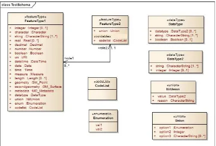
The test application schema
A test application schema has been set up in Enterprise Architect that includes the
different aspects discussed in the previous sub-clause.
The application schema is part of the ShapeChange distribution and unit tests. In the unit
test, the schema documents are compared against the JSON Schema documents included
in the next sub-clauses.
NOTE This test application schema uses the stereotype <<voidable>> on properties to
indicate that the property value may be nil including optional metadata for the nil value
(see 6.2.3.3). ShapeChange supports this as a shorthand notation, the explicit NilUnion
type also included in the application schema models this more explicitly.
Figure 3 - Test application schema
6.3.3
Simple GeoServices JSON encoding rule
The conversion results in the following schemas.
FeatureType1:
{
"title":"FeatureType1",
"description":"This is a feature type.", "type":"object",
"description":"This is an integer.", "type":"integer"
"description":"This is a string.", "type":"string",
"required":true },
"string-2":{
"title":"string",
"description":"This is a string.", "type":"string"
},
"string-3":{
"title":"string",
"links":[
The ShapeChange configuration file used in the conversion is:
<ShapeChangeConfiguration xmlns:xi="http://www.w3.org/2001/XInclude" <parameter name="appSchemaName" value="Test Schema"/>
<parameter name="publicOnly" value="true"/>
6.3.4
Extended GeoServices JSON encoding rule
The conversion results in the following schemas.
FeatureType1:
{
"$schema":"http://json-schema.org/draft-03/schema#", "id":"http://portele.de/ows9/test/FeatureType1.json", "title":"FeatureType1",
"type":"object", "properties":{
"integer":{
"title":"integer",
"description":"This is an integer.", "type":"integer"
},
"description":"This is a data type.",
"$ref":"http://portele.de/ows9/test/DataType.json"
where
http://shapechange.net/tmp/ows9/json/measure.json
is
{
"description":"the value may be a conventional unit of measure symbol or the URI of the definition of a unit of measure"
"type":"string", "required":true }
FeatureType2:
"title":"Reason for null value in property codelist", "type":"string"
"title":"option3",
The ShapeChange configuration file used in the conversion is:
<ShapeChangeConfiguration xmlns:xi="http://www.w3.org/2001/XInclude" <parameter name="appSchemaName" value="Test Schema"/>
</ShapeChangeConfiguration>
6.4
Examples
6.4.1
TDS
TDS is the National System for Geospatial Intelligence (NSG) Topographic Data Store
(TDS). Its content specification is applicable to the collection, storage, manipulation,
interchange, and exploitation of geospatial intelligence data. Systems participating within
the NSG may utilize the NSG TDS Content Specification in order to ensure consistent
NSG-wide geospatial data semantics, adopt common conditions for geospatial
intelligence collection/exchange, support net-centric geospatial services, and achieve
geospatial data interoperability. More information about version 3.0, the version used in
OWS-9, can be found at
https://nsgreg.nga.mil/doc/view?i=82045
.
The JSON schemas for both the extended and simple GeoServices JSON, the GML 3.2
application schema, and a feature catalogue derived from the TDS 3.0 model, as well as
the associated ShapeChange configuration file are available at
http://shapechange.net/tmp/ows9/tds
.
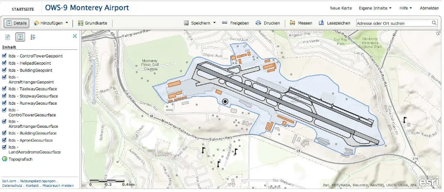
Figure 4 and Figure 5 show selected TDS features in the ArcGIS.com MapClient on top
of the topographic basemap. The features are accessed in JSON from the GeoServices
REST API Feature Service and rendered on the map. If a feature is "clicked", the popup
displays selected properties of the feature.
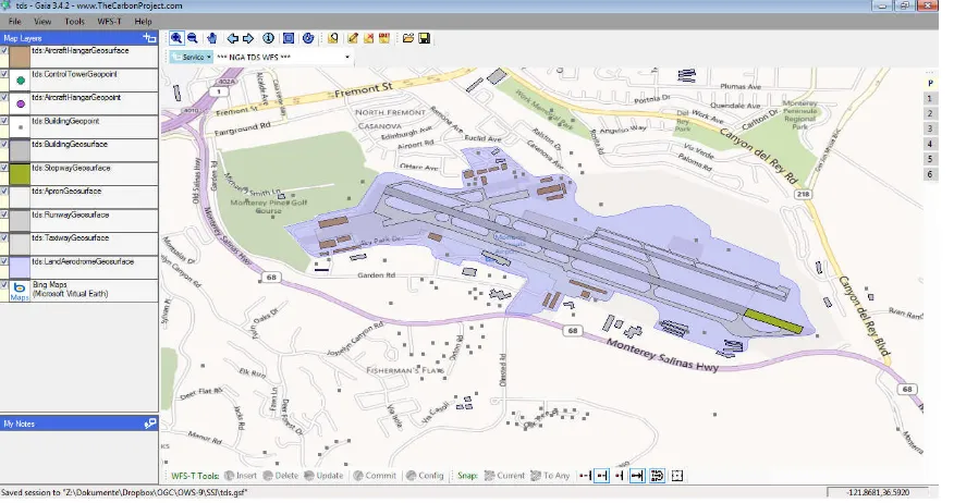
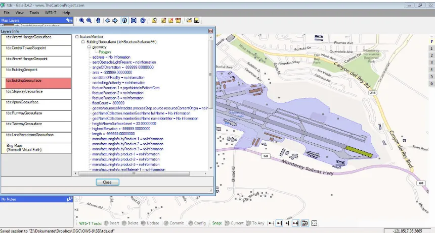
Figure 6 and Figure 7 show the same situation and data in Gaia and the features are
accessed in GML from the WFS.
Figure 5 – Popup showing some of the attributes of a BuidingGeosurface feature (JSON)
Figure 7 – Additional window showing some of the attributes of a BuidingGeosurface feature (GML)
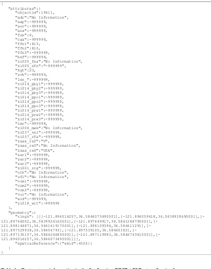
Table 1 shows a BuildingGeopoint feature encoded in JSON and accessed via the
GeoServices REST API Feature Service interface.
Table 3 shows the same feature in encoded in GML and accessed via the WFS interface.
Note that the JSON uses an improved variant of the JSON encoding rule to benefit from
capabilities of the GeoServices REST API. The improvements reduce the amount of data
that needs to be submitted.
The improvements are that the JSON uses
shorter property names and
numeric codes for coded value fields.
In both cases, the shorter names / codes can be considered as aliases for the full names /
coded values. The full names and complete coded values are accessed by clients once as
part of accessing information about a feature type, the clients show the full information,
see Figure 5, for example.
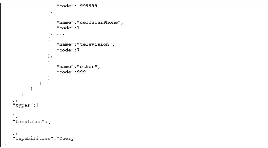
Table 2 shows the information about the BuildingGeosurface feature type. The relevant
parts have been highlighted as bold text.
Table 1 - JSON instance of a BuildingGeosurface feature
"zi005_fna":"No Information", "zi005_nfn":"-999999",
"zi006_mem":"No Information", "zi037_rel":-999999,
"zi037_rfa":-999999, "zsax_rs0":"U",
"zsax_rx3":"No Information", "zsax_rx4":"USA",
"rings": [[[-121.896016257,36.5846073490001],[-121.896059618,36.5838938690001],[-
121.89766002,36.5839924160001],[-121.897649917,36.5841248790001],[- 121.898144871,36.5841619170001],[-121.898109394,36.584611291],[-
121.897529938,36.58456793],[-121.897539105,36.58445182],[- 121.897135157,36.5844246890001],[-121.897119983,36.5846743610001],[-121.896016257,36.5846073490001]]],
"spatialReference":{"wkid":4326}} }
}
Table 2 – Feature type information in the GeoServices REST API Feature Service for
BuildingGeosurface (shortened)
{
"id":12005,
"description":"", "copyrightText":"", "relationships":[
],
"geometryType":"GeometryPolygon", "minScale":25000,
"maxScale":10,
"drawingInfo":{ "renderer":{
"hasAttachments":false,
"htmlPopupType":"ServerHTMLPopupTypeNone", "objectIdField":"objectid",
"name":"awp",
"type":"FieldTypeInteger",
"domain":{
"code":-999999
"capabilities":"Query" }
Table 3 - GML instance of the BuildingGeosurface feature from Table 1
<tds:BuildingGeosurface gml:id="StructureSurfaces19"> <tds:geometry>
<gml:Polygon gml:id="StructureSurfaces.ObjectID.19.SHAPE.Geom_0"> <gml:exterior>
<gml:LinearRing>
<gml:posList>36.5846073490001 -121.896016257 36.5838938690001 -121.896059618 36.5839924160001 121.89766002 36.5841248790001 121.897649917 36.5841619170001 121.898144871 36.584611291 121.898109394 36.58456793 121.897529938 36.58445182 -121.897539105 36.5844246890001 -121.897135157 36.5846743610001 -121.897119983 36.5846073490001 -121.896016257</gml:posList>
</gml:LinearRing> </gml:exterior> </gml:Polygon> </tds:geometry>
<tds:address>No Information</tds:address>
<tds:manufacturingInfo.product-3>noInformation</tds:manufacturingInfo.product-3> <tds:manufacturingInfo.rawMaterial-1>noInformation</tds:manufacturingInfo.rawMaterial-1>
<tds:manufacturingInfo.rawMaterial-2>noInformation</tds:manufacturingInfo.rawMaterial-2>
<tds:manufacturingInfo.rawMaterial-3>noInformation</tds:manufacturingInfo.rawMaterial-3>
<tds:navigationLandmark>noInformation</tds:navigationLandmark> <tds:note.memorandum>No Information</tds:note.memorandum>
<tds:religiousInfo.religiousDesignation>noInformation</tds:religiousInfo.religiousDesigna tion>
<tds:religiousInfo.religiousFacilityType>noInformation</tds:religiousInfo.religiousFacili tyType>
<tds:restriction.securityAttributesGroup_resClassification>U</tds:restriction.securityAtt ributesGroup_resClassification>
<tds:restriction.securityAttributesGroup_resNonIntelComMarkings>No
Information</tds:restriction.securityAttributesGroup_resNonIntelComMarkings> <tds:restriction.securityAttributesGroup_resOwnerProducer>No
Information</tds:restriction.securityAttributesGroup_resOwnerProducer> <tds:roofShape-1>noInformation</tds:roofShape-1>
<tds:roofShape-2>noInformation</tds:roofShape-2> <tds:roofShape-3>noInformation</tds:roofShape-3>
<tds:specifiedEnumerants>No Information</tds:specifiedEnumerants> <tds:uniqueEntityIdentifier>No Information</tds:uniqueEntityIdentifier> <tds:verticalConstMaterial-1>noInformation</tds:verticalConstMaterial-1> <tds:verticalConstMaterial-2>noInformation</tds:verticalConstMaterial-2> <tds:verticalConstMaterial-3>noInformation</tds:verticalConstMaterial-3> <tds:verticalObstIdentifier>No Information</tds:verticalObstIdentifier> <tds:width>-999999.00000000</tds:width>
<tds:wirelessTelecomInfo.wirelessTelecomType>noInformation</tds:wirelessTelecomInfo.wirel essTelecomType>
</tds:BuildingGeosurface>