Open Geospatial Consortium Inc.
Date:
2010-02-25
Reference number of this document:
0GC 06-080r4
Version:
1.0
Category
: OpenGIS
®Implementation Standard
Editor:
Jerome Gasperi
OpenGIS Geography Markup Language (GML)
Application Schema for Earth Observation Products
Copyright (c) 2010 Open Geospatial Consortium
To obtain additional rights of use, visit http://www.opengeospatial.org/legal/.
Warning
Recipients of this document are invited to submit, with their comments, notification
of any relevant patent rights of which they are aware and to provide supporting
documentation
Document type :
OGC Implementation Standard
Document subtype :
GML Application Schema
Document stage:
Adopted
ii
Copyright © 2012 Open Geospatial Consortium
License Agreement
Permission is hereby granted by the Open Geospatial Consortium, ("Licensor"), free of charge and subject to the terms set forth below, to any person obtaining a copy of this Intellectual Property and any associated documentation, to deal in the Intellectual Property without restriction (except as set forth below), including without limitation the rights to implement, use, copy, modify, merge, publish, distribute, and/or sublicense copies of the Intellectual Property, and to permit persons to whom the Intellectual Property is furnished to do so, provided that all copyright notices on the intellectual property are retained intact and that each person to whom the Intellectual Property is furnished agrees to the terms of this Agreement.
If you modify the Intellectual Property, all copies of the modified Intellectual Property must include, in addition to the above copyright notice, a notice that the Intellectual Property includes modifications that have not been approved or adopted by LICENSOR. THIS LICENSE IS A COPYRIGHT LICENSE ONLY, AND DOES NOT CONVEY ANY RIGHTS UNDER ANY PATENTS THAT MAY BE IN FORCE ANYWHERE IN THE WORLD.
THE INTELLECTUAL PROPERTY IS PROVIDED "AS IS", WITHOUT WARRANTY OF ANY KIND, EXPRESS OR IMPLIED, INCLUDING BUT NOT LIMITED TO THE WARRANTIES OF MERCHANTABILITY, FITNESS FOR A PARTICULAR PURPOSE, AND NONINFRINGEMENT OF THIRD PARTY RIGHTS. THE COPYRIGHT HOLDER OR HOLDERS INCLUDED IN THIS NOTICE DO NOT WARRANT THAT THE FUNCTIONS CONTAINED IN THE INTELLECTUAL PROPERTY WILL MEET YOUR REQUIREMENTS OR THAT THE OPERATION OF THE INTELLECTUAL PROPERTY WILL BE UNINTERRUPTED OR ERROR FREE. ANY USE OF THE INTELLECTUAL PROPERTY SHALL BE MADE ENTIRELY AT THE USER’S OWN RISK. IN NO EVENT SHALL THE COPYRIGHT HOLDER OR ANY CONTRIBUTOR OF INTELLECTUAL PROPERTY RIGHTS TO THE INTELLECTUAL PROPERTY BE LIABLE FOR ANY CLAIM, OR ANY DIRECT, SPECIAL, INDIRECT OR CONSEQUENTIAL DAMAGES, OR ANY DAMAGES WHATSOEVER RESULTING FROM ANY ALLEGED INFRINGEMENT OR ANY LOSS OF USE, DATA OR PROFITS, WHETHER IN AN ACTION OF CONTRACT, NEGLIGENCE OR UNDER ANY OTHER LEGAL THEORY, ARISING OUT OF OR IN CONNECTION WITH THE IMPLEMENTATION, USE, COMMERCIALIZATION OR PERFORMANCE OF THIS INTELLECTUAL PROPERTY. This license is effective until terminated. You may terminate it at any time by destroying the Intellectual Property together with all copies in any form. The license will also terminate if you fail to comply with any term or condition of this Agreement. Except as provided in the following sentence, no such termination of this license shall require the termination of any third party end-user sublicense to the Intellectual Property which is in force as of the date of notice of such termination. In addition, should the Intellectual Property, or the operation of the Intellectual Property, infringe, or in LICENSOR’s sole opinion be likely to infringe, any patent, copyright, trademark or other right of a third party, you agree that LICENSOR, in its sole discretion, may terminate this license without any compensation or liability to you, your licensees or any other party. You agree upon termination of any kind to destroy or cause to be destroyed the Intellectual Property together with all copies in any form, whether held by you or by any third party. Except as contained in this notice, the name of LICENSOR or of any other holder of a copyright in all or part of the Intellectual Property shall not be used in advertising or otherwise to promote the sale, use or other dealings in this Intellectual Property without prior written authorization of LICENSOR or such copyright holder. LICENSOR is and shall at all times be the sole entity that may authorize you or any third party to use certification marks, trademarks or other special designations to indicate compliance with any LICENSOR standards or specifications.
This Agreement is governed by the laws of the Commonwealth of Massachusetts. The application to this Agreement of the United Nations Convention on Contracts for the International Sale of Goods is hereby expressly excluded. In the event any provision of this Agreement shall be deemed unenforceable, void or invalid, such provision shall be modified so as to make it valid and enforceable, and as so modified the entire Agreement shall remain in full force and effect. No decision, action or inaction by LICENSOR shall be construed to be a waiver of any rights or remedies available to it.
Contents
Page
1
Scope ...1
2
Compliance ...1
3
Normative references ...1
4
Terms and definitions ...2
5
Conventions ...3
5.1
Abbreviated terms ...3
5.2
Namespace prefix conventions ...3
6
Overview ...4
6.1
General concepts ...4
6.2
GML Observation ...6
6.2.1
Earth Observation mapping on gml:Observation ...7
6.3
General rules ...7
6.3.1
Language rules ...8
6.3.2
Extensions rules ...8
6.3.2.1
Thematic extended namespace ...8
6.3.2.2
Mission specific extended namespace ...9
6.3.3
Use of Schematron ...10
6.3.3.1
Schematron basics ...10
6.3.3.2
Schematron rules for eop ...11
6.3.4
CodeList ...12
6.3.5
Units of measure ...13
6.3.6
Use of xlink ...13
6.3.7
GML restrictive use ...14
7
EO Products application schemas ...14
7.1
General EO product data schema ...14
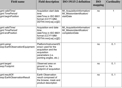
7.1.1
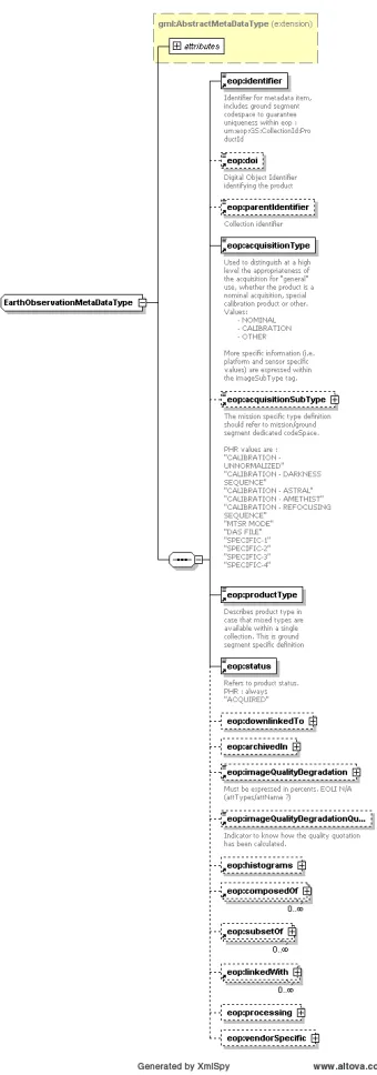
EarthObservationMetadata ...17
7.1.2
EarthObservationEquipment ...21
7.1.3
Footprint ...24
7.1.4
EarthObservationResult ...25
7.2
Thematic EO product data schema ...28
7.2.1
Optical EO Product data schema ...28
7.2.2
Radar EO Product data schema ...30
7.2.3
Atmospheric EO Product data schema ...32
7.3
Issues ...34
Copyright © 2010 Open Geospatial Consortium, Inc.
iii
Figures
Page
Figure 1 : A layered view of GML EO Products data.. ... 5
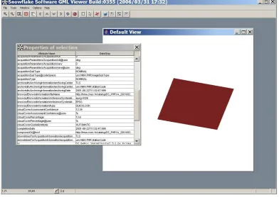
Figure 2 : A generic GML viewer understand the “gml” vocabulary and thus displays the
product footprint (gml:multiExtentOf property). With no semantic knowledge on the
EO product schema, the reader is able to displays the related attributes in an
xpath/value fashion ... 6
Figure 3 : schematron processing for Earth Observation products ... 11
Figure 5: <
eop:EarthObservationType>
diagram ... 15
Figure 6 :
<eop:EarthObservationMetadata>
diagram ... 17
Figure 8 :
<eop:EarthObservationEquipment>
diagram ... 21
Figure 10 :
<eop:Footprint>
diagram ... 25
Figure 12 : <
eop:EarthObservationResult>
diagram ... 26
Tables
Page
i.
Preface
This OGC Implementation Standard defines a Geography Markup Language (GML)
version 3.1.1 application schema for describing Earth Observation products (EO
products) within the HMA (Heterogeneous EO Missions Accessibility) Application
Profile for the OGC
TMCatalogue Services Standard v2.0.0 (with Corrigendum) [OGC
04-021r3]
Suggested additions, changes, and comments on this draft report are welcome and
encouraged. Such suggestions may be submitted by email message.
ii.
Document terms and definitions
This document uses the specification terms defined in Subclause 5.3 of [OGC 05-008]. In
particular, the word “shall” (not “must”) is the verb form used to indicate a requirement
to be strictly followed to conform to this standard.
iii.
Submitting organizations
This application schema is being submitted to the OGC by the following organizations:
•
ESA – European Space Agency
•
CNES – French Space Agency
•
EUSC
•
Spacebel s.a.
•
Spot Image
The editors would like to acknowledge that this work is the result of collaboration and
review of many organizations and would like to thank for the comments and
contributions from:
•
ASI
•
Conterra
Copyright © 2010 Open Geospatial Consortium, Inc.
v
•
Eumetsat
•
MDA
Note : this does not imply a complete endorsement from these organizations).
iv.
Document contributor contact points
All questions regarding this submission should be directed to the editor or the submitters:
Jerome Gasperi (Editor)
CNES
jerome.gasperi <at> cnes.fr
Contributors:
Name Organization
Christophe Dabin
CNES
Patrick Floissac
MAGELLIUM (CNES Sub contractor)
Jolyon Martin
ESA
v.
Revision history
Date Release
Editor Primary clauses
modified
Description
11 May 2006
0.1.0
Jerome Gasperi
N/A
Initial document
29 May 2006
0.1.1
Jerome Gasperi
N/A
Updated after telecom meeting
21 August 2006
0.1.2
Jerome Gasperi
N/A
Update document after Ron
Lake comments.
Update document regarding
version 0.91 of the XML
schemas
19 September 2006 0.1.3
Jerome Gasperi
N/A
Update document regarding
version 0.92 of the XML
schema
24 November 2006 0.1.4
Jerome Gasperi
N/A
Use of gml:Observation for
schema description.
Update document regarding
version 0.94 of the XML
schema
8 December 2006
0.1.4
06-080r1
Jolyon Martin
N/A
Updated draft re-numbered as
06-080r1
Minor update of introduction
7 February 2007
0.1.4
080r2
Conformance with hma RIDS
(CDR#34, CDR#35, CDR#49,
CDR#58, CDR#71).
Update document regarding
version 0.95 of the XML
schema
Schemas import a gml subset
(gmlSubset.xsd given in annex)
21 May 2007
0.1.4
06-080r1
Jerome Gasperi
N/A
Updated draft re-numbered as
06-080r1
Change pointingAngles to
incidenceAngles.
Add hma:composedOf,
hma:subsetOf and
hma:linkedWith within
EarthObservationMetadata
Update document regarding
version 1.0beta of the XML
schema
18 june 2007
0.9.0
06-080r2
Jerome Gasperi
N/A
Updated draft re-numbered as
06-080r2
Change gml:extentOf to
gml:multiExtentOf to allow
multi-polygons in footprint
Update document regarding
version 1.0 of the XML schema
1 august 2007
0.9.1
06-080r2
Jerome Gasperi
N/A
Change hma namespace to eop
(RIDS IMPR#93)
Change opt namespace to opt
(RIDS IMPR#94)
Update document regarding
version 1.1 of the XML schema
22 november 2007 0.9.1
06-080r3
Jolyon Martin
N/A
Update of OGC revision no. For
re-submission to TC
20 march 2008
0.9.2
06-080r4
Jerome Gasperi
N/A
Update document regarding
version 1.2 of the XML schema
RIDS DAIL-RD-EDT-EN-0101
: Correct typos in the document
(acrossTrackIncidenceAngle,
orbitType and archivingCenter)
Add the following elements :
o
mandatory “version”
attribute
o
ProcessingInformation/proc
essingCenter
Copyright © 2010 Open Geospatial Consortium, Inc.
vii
RIDS
DAIL-RD-EDT-EN-0003:
Add the following elements:
o
wrsLongitudeGrid
o
wrsLatitudeGrid
21 july 2008
0.9.3
06-080r4
Jerome Gasperi
N/A
Update document regarding
version 1.2.1 of the XML
schema
Correct a schema issue for
elements wrsLongitudeGrid and
wrsLatitudeGrid
RIDS
DAIL-RD-EDT-EN-0005:
Add ‘statusDetail’ element.
Update ‘status’ element.
Jan 16 2010
1.0
Carl Reed
Jerome Gasperi
Various
Preparation for publication as an
OGC standard.
Corrects inconsistency between
this document and the
corresponding schema
vi.
Changes to OGC Standards
The existing OGC™ standards do not need any changes to accommodate the technical
contents of this standard.
vii.
Future work
This profile is designed to be used mainly in the cataloguing of EO metadata, using
the CS-W ebRIM application profile. This standard (07-006) is based on OGC Filter
Encoding Standard that uses GML 3.1.1. For consistancy, this profile also use GML
3.1.1.
Foreword
This OGC standard specifies a Geographic Markup Language (GML) version 3.1.1
application schema [OGC 03-105r1 and 04-092r4] . The schema is a GML application
schema as specified in Subclause 23 of [OGC 03-105r1].
Attention is drawn to the possibility that some of the elements of this document may be
the subject of patent rights. The Open Geospatial Consortium Inc. shall not be held
responsible for identifying any or all such patent rights.
Copyright © 2010 Open Geospatial Consortium, Inc.
ix
Introduction
The OGC Geography Markup Language is an XML grammar written in XML Schema
for the modelling, transport, and storage of geographic information.
From the GML standard, “GML provides a variety of kinds of objects for describing
geography including features, coordinate reference systems, geometry, topology, time,
units of measure and generalized values. A geographic feature is an abstraction of a real
world phenomenon; it is a geographic feature if it is associated with a location relative to
the Earth”.
EO data product collections are usually structured to contain data items derived from a
sensor onboard a satellite or series of sensors. The key characteristics differentiating
these products are date of acquisition, location and in some cases, such as the optical
imagery, the possible presence of cloud, haze, smokes or other atmospheric or on ground
phenomena obscuring the image. These are the key characteristics; there are however
other metadata that are required to identify products of interest.
From a user point of view, an EO data product can be naturally described with a spatial
extension (e.g. the geographic footprint of a satellite acquisition) and several attributes
describing the metadata (e.g. date of acquisition, etc.). Indeed this point of view is
consistent with a GML representation of the data.
The intent of this standard is to describe as a GML version 3.1.1 application schema that
can be used with service interfaces for EO data product that can be supported by many
data providers (satellite operators, data distributors …). The metadata described is that
which is commonly provided through catalogue interfaces, it does not necessarily include
all of the metadata that is present in the actual EO data product (e.g. calibration
coefficients etc.).
1
GML Application Schema for EO Products
1
Scope
This application schema document describes the encodings required to describe Earth
Observation (EO) products from general to mission specific characteristics.
2
Compliance
This document specifies three compliance levels :
-
The general level, or “eop” level, describes the general EO Products schema;
-
The thematic level extends the “eop” level to describes thematic EO Products
such as optical, radar or atmospheric products (respectively “opt”, “sar”, “atm”
levels);
-
The mission specific level extends one of the “thematic” level to describes
mission specific EO Products. For instance the French Pleiades mission uses the
“phr” level which extends the “opt” thematic level.
EO Products data encoded using this application schema shall produce XML documents
that are fully compliant with normative XML Schema Documents associated with this
standard(i.e. eop.xsd for general EO Products, opt.xsd, sar.xsd and atm.xsd for optical,
radar and atmospheric products respectively).
More specifically, compliance with this standard shall be checked using all the relevant
tests specified in Annex A (normative).
3
Normative references
The following normative documents contain provisions that, through reference in this
text, constitute provisions of this document. For dated references, subsequent
amendments to, or revisions of, any of these publications do not apply. For undated
references, the latest edition of the normative document referred to applies.
OGC 03-105r1, OpenGIS Geography Markup Language (GML) Implementation
OGC 04-092r4, GML 3.1.1 schemas
OGC 05-008, OGC Web Services Common Standard, Version 1.0.0
OGC 05-010, URNs of definitions in ogc namespace (Recommendation Paper), Version
1.0.0
W3C, Extensible Markup Language (XML) 1.0 (Second Edition), W3C
Recommendation, 6 October 2000, http://www.w3.org/TR/REC-xml
W3C, XML Schema Part 1: Structures, http://www.w3.org/TR/xmlschema-1
W3C, XML Schema Part 2: Datatypes, http://www.w3.org/TR/xmlschema-2
W3C, Namespaces in XML, http://www.w3.org/TR/1999/REC-xml-names-19990114
In addition to this document, this standard includes several normative XML Schema files.
Following approval of this document, these schemas will be posted online at the
http://schemas.opengis.net. These XML Schema files are also bundled with the present
document. In the event of a discrepancy between the bundled and online versions of the
XML Schema files, the online files shall be considered authoritative.
4
Terms and definitions
For the purposes of this standard, the definitions specified in Clause 4 of the OWS
Common Implementation Standard [OGC 05-008] shall apply. In addition, the following
terms and definitions apply.
client
software component that can invoke an operation from a server
datastrip
A satellite acquisition
geographic information
information concerning phenomena implicitly or explicitly associated with a location
relative to the Earth [ISO 19128 draft]
identifier
a character string that may be composed of numbers and characters that is exchanged
between the client and the server with respect to a specific identity of a resource
qualified name
name that is prefixed with its naming context
Copyright © 2010 Open Geospatial Consortium, Inc.
3
request
invocation of an operation by a client
response
result of an operation, returned from a server to a client
scene
The cutting of a datastrip into part. For PHR mission, a scene is a 20x20 km^2 square
part.
schema
formal description of a model [ISO 19101, ISO 19103, ISO 19109, ISO 19118]
5
Conventions
5.1
Abbreviated terms
The abbreviated terms used in this document include:
ATM Atmospheric
EO
Earth Observation
EOP
Earth Observation Product
GML Geography Markup Language
HMA Heterogeneous
Mission
Accessibility
OGC
Open Geospatial Consortium
PHR
Pleiades High Resolution
OPT OPTical
SAR
Synthetic Aperture Radar
XML eXtensible
Markup
Language
5.2
Namespace prefix conventions
The namespace prefixes used in this document are not normative and are merely chosen for
convenience; they may appear in examples without being formally declared, and have no
semantic significance. The namespaces to which the prefixes correspond are normative,
however.
eop
http://earth.esa.int/eop
General EO product schema namespace
opt
http://earth.esa.int/opt
Optical High Resolution EO product schema
namespace
sar
http://earth.esa.int/sar
Radar EO product schema namespace
atm http://earth.esa.int/atm
Atmospheric EO product schema
namespace
phr
http://eop.cnes.fr/phr
Pleiades High Resolution product schema
namespace
Table 1 : namespace mappings
6
Overview
This section focuses on the purpose and requirements for this standard. In particular, the
document describes the context of use of the EO Product application schema.
6.1
General concepts
The approach consists in modelling EO data product through a GML application
schema.ISO definitions are specified for attributes where available, although not the full
ISO schema is used for the structural definitions, which would lead to a less efficient
overall structure.
The general mechanism is to create a schema with a dedicated namespace for each level
of specificity from a general description which is common to each EO Product to a
restricted description for specific mission EO Product. Each level of specificity is an
extension of the previous one.
The General EO product schema is the main application schema for EO Product data. It is
associated with the “eop” namespace.
Each Thematic EO product schemas extends the “eop” schema :
-
The Optical EO Product schema is used to describe optical products. It is
associated with the “opt” namespace;
-
The SAR EO Product schema is used to describe radar products. It is associated
with the “sar” namespace;
-
The Atmospheric EO Product schema is used to describe atmospheric products. It
is associated with the “atm” namespace;
Cop
1)
to create an efficient schema set that describes EO Product metadata
concentrating on the core metadata that key characteristics differentiate a products
within a collection.
2)
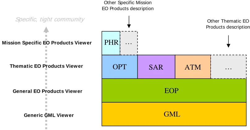
to profit by the widespread use of GML so that our products can be displayed by a
large variety of GML viewer from generic one, which will see EO Products as
features with footprint and “unknown” metadata, to EO Product specific one,
which will understand the semantic of these metadata (cf. Figure 1)
Other Specific Mission EO Products description
Mission Specific EO Products View er
Thematic EO Products View er
General EO Products View er
Generic GML View er
GML
…
…
Other Thematic EO Products description