OGC 11-052r4
Open Geospatial Consortium
Approval Date: 2012-04-27
Publication Date: 2012-09-10
Document uri:http://www.opengis.net/doc/IS/geosparql/1.0
Reference number of this OGC® project document: OGC 11-052r4
Version: 1.0
Category: OGC® Implementation Standard
Editors: Matthew Perry and John Herring
OGC
GeoSPARQL -
A Geographic Query Language for RDF DataCopyright notice
Copyright © 2012 Open Geospatial Consortium
To obtain additional rights of use, visit http://www.opengeospatial.org/legal/.
Warning
This document is an OGC Member approved international standard. This document is available on a royalty free, non-discriminatory basis. Recipients of this document are invited to submit, with their comments, notification of any relevant patent rights of which they are aware and to provide supporting documentation.
Document type: OGC® Standard Document subtype: Encoding
OGC 11-052r4
ii Copyright © 2012 Open Geospatial Consortium
License Agreement
Permission is hereby granted by the Open Geospatial Consortium, ("Licensor"), free of charge and subject to the terms set forth below, to any person obtaining a copy of this Intellectual Property and any associated documentation, to deal in the Intellectual Property without restriction (except as set forth below), including without limitation the rights to implement, use, copy, modify, merge, publish, distribute, and/or sublicense copies of the Intellectual Property, and to permit persons to whom the Intellectual Property is furnished to do so, provided that all copyright notices on the intellectual property are retained intact and that each person to whom the Intellectual Property is furnished agrees to the terms of this Agreement.
If you modify the Intellectual Property, all copies of the modified Intellectual Property must include, in addition to the above copyright notice, a notice that the Intellectual Property includes modifications that have not been approved or adopted by LICENSOR. THIS LICENSE IS A COPYRIGHT LICENSE ONLY, AND DOES NOT CONVEY ANY RIGHTS UNDER ANY PATENTS THAT MAY BE IN FORCE ANYWHERE IN THE WORLD.
THE INTELLECTUAL PROPERTY IS PROVIDED "AS IS", WITHOUT WARRANTY OF ANY KIND, EXPRESS OR IMPLIED, INCLUDING BUT NOT LIMITED TO THE WARRANTIES OF MERCHANTABILITY, FITNESS FOR A PARTICULAR PURPOSE, AND NONINFRINGEMENT OF THIRD PARTY RIGHTS. THE COPYRIGHT HOLDER OR HOLDERS INCLUDED IN THIS NOTICE DO NOT WARRANT THAT THE FUNCTIONS CONTAINED IN THE INTELLECTUAL PROPERTY WILL MEET YOUR REQUIREMENTS OR THAT THE OPERATION OF THE INTELLECTUAL PROPERTY WILL BE
UNINTERRUPTED OR ERROR FREE. ANY USE OF THE INTELLECTUAL PROPERTY SHALL BE MADE ENTIRELY AT THE USER’S OWN RISK. IN NO EVENT SHALL THE COPYRIGHT HOLDER OR ANY CONTRIBUTOR OF
INTELLECTUAL PROPERTY RIGHTS TO THE INTELLECTUAL PROPERTY BE LIABLE FOR ANY CLAIM, OR ANY DIRECT, SPECIAL, INDIRECT OR CONSEQUENTIAL DAMAGES, OR ANY DAMAGES WHATSOEVER RESULTING FROM ANY ALLEGED INFRINGEMENT OR ANY LOSS OF USE, DATA OR PROFITS, WHETHER IN AN ACTION OF CONTRACT, NEGLIGENCE OR UNDER ANY OTHER LEGAL THEORY, ARISING OUT OF OR IN CONNECTION WITH THE IMPLEMENTATION, USE, COMMERCIALIZATION OR PERFORMANCE OF THIS INTELLECTUAL PROPERTY. This license is effective until terminated. You may terminate it at any time by destroying the Intellectual Property together with all copies in any form. The license will also terminate if you fail to comply with any term or condition of this Agreement. Except as provided in the following sentence, no such termination of this license shall require the termination of any third party end-user sublicense to the Intellectual Property which is in force as of the date of notice of such termination. In addition, should the Intellectual Property, or the operation of the Intellectual Property, infringe, or in LICENSOR’s sole opinion be likely to infringe, any patent, copyright, trademark or other right of a third party, you agree that LICENSOR, in its sole discretion, may terminate this license without any compensation or liability to you, your licensees or any other party. You agree upon termination of any kind to destroy or cause to be destroyed the Intellectual Property together with all copies in any form, whether held by you or by any third party. Except as contained in this notice, the name of LICENSOR or of any other holder of a copyright in all or part of the Intellectual Property shall not be used in advertising or otherwise to promote the sale, use or other dealings in this Intellectual Property without prior written authorization of LICENSOR or such copyright holder. LICENSOR is and shall at all times be the sole entity that may authorize you or any third party to use certification marks, trademarks or other special designations to indicate compliance with any LICENSOR standards or specifications.
This Agreement is governed by the laws of the Commonwealth of Massachusetts. The application to this Agreement of the United Nations Convention on Contracts for the International Sale of Goods is hereby expressly excluded. In the event any provision of this Agreement shall be deemed unenforceable, void or invalid, such provision shall be modified so as to make it valid and enforceable, and as so modified the entire Agreement shall remain in full force and effect. No decision, action or inaction by LICENSOR shall be construed to be a waiver of any rights or remedies available to it.
OGC 11-052r4
Copyright © 2012 Open Geospatial Consortium
iii
Contents
i. Preface ... xi
ii. Submitting organizations ... xi
iii. Submission contact points ... xii
iv. Revision history ... xii
v. Changes to the OGC® Abstract Specification ... xiii
Foreword ... xiv
Introduction ... xv
1 Scope ... 1
2 Conformance ... 1
3 Normative references ... 3
4 Terms and definitions ... 4
5 Conventions ... 4
5.1 Symbols (and abbreviated terms) ... 4
5.2 XML Namespaces ... 5
5.3 Placeholder URIs ... 5
5.4 RDF Serializations ... 5
6 Core ... 6
6.1 SPARQL ... 6
6.2 Classes ... 6
6.2.1 Class: geo:SpatialObject ... 6
6.2.2 Class: geo:Feature ... 6
7 Topology Vocabulary Extension (relation_family) ... 7
7.1 Parameters ... 7
7.2 Requirements for Simple Features Relation Family (relation_family=Simple Features) ... 8
7.3 Requirements for Egenhofer Relation Family (relation_family=Egenhofer) ... 8
7.4 Requirements for RCC8 Relation Family (relation_family=RCC8) ... 9
7.5 Equivalent RCC8, Egenhofer and Simple Features Topological Relations ... 10
8 Geometry Extension (serialization, version) ... 11
OGC 11-052r4
iv Copyright © 2012 Open Geospatial Consortium
8.2 Geometry Classes and Properties ... 12
8.2.1 Class: geo:Geometry ... 12
8.3 Standard Properties for geo:Feature ... 12
8.4 Standard Properties for geo:Geometry ... 14
8.4.1 Property: geo:dimension ... 14
8.4.2 Property: geo:coordinateDimension ... 14
8.4.3 Property: geo:spatialDimension ... 15
8.4.4 Property: geo:isEmpty ... 15
8.4.5 Property: geo:isSimple ... 15
8.4.6 Property: geo:hasSerialization ... 15
8.5 Requirements for WKT Serialization (serialization=WKT) ... 16
8.5.1 RDFS Datatypes ... 16
8.5.2 Serialization Properties ... 17
8.6 Requirements for GML Serialization (serialization=GML) ... 18
8.6.1 RDFS Datatypes ... 18
8.6.2 Serialization Properties ... 19
8.7 Non-topological Query Functions ... 19
8.7.1 Function: geof:distance ... 20
8.7.2 Function: geof:buffer ... 21
8.7.3 Function: geof:convexHull ... 21
8.7.4 Function: geof:intersection ... 21
8.7.5 Function: geof:union ... 21
8.7.6 Function: geof:difference ... 21
8.7.7 Function: geof:symDifference ... 22
8.7.8 Function: geof:envelope ... 22
8.7.9 Function: geof:boundary ... 22
8.7.10 Function: geof:getsrid ... 22
9 Geometry Topology Extension (relation_family, serialization, version) ... 22
9.1 Parameters ... 23
9.2 Common Query Functions ... 23
9.3 Requirements for Simple Features Relation Family (relation_family=Simple Features) ... 23
9.4 Requirements for Egenhofer Relation Family (relation_family=Egenhofer) ... 25
9.5 Requirements for RCC8 Relation Family (relation_family=RCC8) ... 26
10 RDFS Entailment Extension (relation_family, serialization, version) ... 28
10.1 Parameters ... 28
10.2 Common Requirements ... 28
10.3 Requirements for WKT Serialization (serialization=WKT) ... 28
10.3.1 Geometry Class Hierarchy ... 28
10.4 Requirements for GML Serialization (serialization=GML) ... 29
10.4.1 Geometry Class Hierarchy ... 29
OGC 11-052r4
Copyright © 2012 Open Geospatial Consortium
v
11.1 Parameters ... 30
11.2 Requirements for Simple Features Relation Family (relation_family=Simple Features) ... 31
11.3 Requirements for Egenhofer Relation Family (relation_family=Egenhofer) ... 31
11.4 Requirements for RCC8 Relation Family (relation_family=RCC8) ... 32
11.5 Special Considerations ... 33
12 Future Work ... 33
Annex A (normative) Abstract Test Suite ... 35
Annex B (informative) GeoSPARQL Examples ... 48
OGC 11-052r4
vi Copyright © 2012 Open Geospatial Consortium
Table of Requirements
Req 1 Implementations shall support the SPARQL Query Language for RDF [W3C SPARQL], the SPARQL Protocol for RDF [W3C SPARQL Protocol] and the SPARQL Query Results XML Format [W3C
SPARQL Result Format]. ... 6 Req 2 Implementations shall allow the RDFS class geo:SpatialObject to
be used in SPARQL graph patterns. ... 6 Req 3 Implementations shall allow the RDFS class geo:Feature to be used
in SPARQL graph patterns. ... 7 Req 4 Implementations shall allow the properties geo:sfEquals,
geo:sfDisjoint, geo:sfIntersects, geo:sfTouches,
geo:sfCrosses, geo:sfWithin, geo:sfContains,
geo:sfOverlaps to be used in SPARQL graph patterns. ... 8
Req 5 Implementations shall allow the properties geo:ehEquals,
geo:ehDisjoint, geo:ehMeet, geo:ehOverlap,
geo:ehCovers, geo:ehCoveredBy, geo:ehInside,
geo:ehContains to be used in SPARQL graph patterns. ... 9 Req 6 Implementations shall allow the properties geo:rcc8eq,
geo:rcc8dc, geo:rcc8ec, geo:rcc8po, geo:rcc8tppi,
geo:rcc8tpp, geo:rcc8ntpp, geo:rcc8ntppi to be used in
SPARQL graph patterns. ... 9 Req 7 Implementations shall allow the RDFS class geo:Geometry to be used
in SPARQL graph patterns. ... 12 Req 8 Implementations shall allow the properties geo:hasGeometry and
geo:hasDefaultGeometry to be used in SPARQL graph patterns. ... 12 Req 9 Implementations shall allow the properties geo:dimension,
geo:coordinateDimension, geo:spatialDimension,
geo:isEmpty, geo:isSimple, geo:hasSerialization to be
used in SPARQL graph patterns. ... 14 Req 10 All RDFS Literals of type geo:wktLiteral shall consist of an
optional URI identifying the coordinate reference system followed by Simple Features Well Known Text (WKT) describing a geometric value. Valid geo:wktLiterals are formed by concatenating a valid,
OGC 11-052r4
Copyright © 2012 Open Geospatial Consortium
vii U+0020 character) as a separator, and a WKT string as defined in
Simple Features [ISO 19125-1]. ... 16 Req 11 The URI
<http://www.opengis.net/def/crs/OGC/1.3/CRS84> shall be assumed as the spatial reference system for geo:wktLiterals that do not specify an explicit spatial reference system URI. ... 16 Req 12 Coordinate tuples within geo:wktLiterals shall be interpreted
using the axis order defined in the spatial reference system used. ... 17 Req 13 An empty RDFS Literal of type geo:wktLiteral shall be interpreted
as an empty geometry. ... 17 Req 14 Implementations shall allow the RDF property geo:asWKT to be used
in SPARQL graph patterns. ... 17 Req 15 All geo:gmlLiterals shall consist of a valid element from the GML
schema that implements a subtype of GM_Object as defined in [OGC
07-036]. ... 18 Req 16 An empty geo:gmlLiteral shall be interpreted as an empty
geometry. ... 19 Req 17 Implementations shall document supported GML profiles. ... 19 Req 18 Implementations shall allow the RDF property geo:asGML to be used
in SPARQL graph patterns. ... 19 Req 19 Implementations shall support geof:distance, geof:buffer,
geof:convexHull, geof:intersection, geof:union,
geof:difference, geof:symDifference, geof:envelope and
geof:boundary as SPARQL extension functions, consistent with the definitions of the corresponding functions (distance, buffer,
convexHull, intersection, difference, symDifference,
envelope and boundary respectively) in Simple Features [ISO
19125-1]. ... 19 Req 20 Implementations shall support geof:getSRID as a SPARQL
extension function. ... 22 Req 21 Implementations shall support geof:relate as a SPARQL extension
function, consistent with the relate operator defined in Simple
Features [ISO 19125-1]. ... 23 Req 22 Implementations shall support geof:sfEquals, geof:sfDisjoint,
geof:sfIntersects, geof:sfTouches, geof:sfCrosses,
OGC 11-052r4
viii Copyright © 2012 Open Geospatial Consortium
SPARQL extension functions, consistent with their corresponding
DE-9IM intersection patterns, as defined by Simple Features [ISO 19125-1]. .... 23 Req 23 Implementations shall support geof:ehEquals, geof:ehDisjoint,
geof:ehMeet, geof:ehOverlap, geof:ehCovers,
geof:ehCoveredBy, geof:ehInside, geof:ehContains as SPARQL extension functions, consistent with their corresponding
DE-9IM intersection patterns, as defined by Simple Features [ISO 19125-1]. .... 25 Req 24 Implementations shall support geof:rcc8eq, geof:rcc8dc,
geof:rcc8ec, geof:rcc8po, geof:rcc8tppi, geof:rcc8tpp,
geof:rcc8ntpp, geof:rcc8ntppi as SPARQL extension functions, consistent with their corresponding DE-9IM intersection patterns, as
defined by Simple Features [ISO 19125-1]. ... 26 Req 25 Basic graph pattern matching shall use the semantics defined by the
RDFS Entailment Regime [W3C SPARQL Entailment]. ... 28 Req 26 Implementations shall support graph patterns involving terms from an
RDFS/OWL class hierarchy of geometry types consistent with the one in the specified version of Simple Features [ISO 19125-1]. ... 29
Req 27 Implementations shall support graph patterns involving terms from an RDFS/OWL class hierarchy of geometry types consistent with the GML schema that implements GM_Object using the specified version of
GML [OGC 07-036]. ... 29 Req 28 Basic graph pattern matching shall use the semantics defined by the
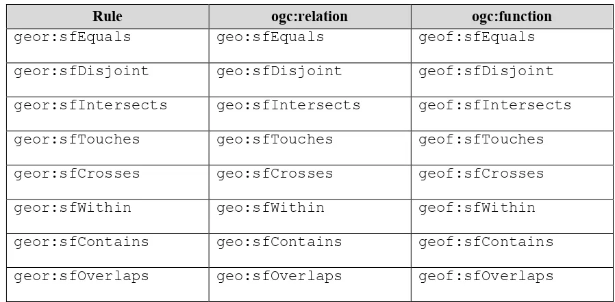
RIF Core Entailment Regime [W3C SPARQL Entailment] for the RIF rules [W3C RIF Core] geor:sfEquals, geor:sfDisjoint,
geor:sfIntersects, geor:sfTouches, geor:sfCrosses,
geor:sfWithin, geor:sfContains, geor:sfOverlaps. ... 31
Req 29 Basic graph pattern matching shall use the semantics defined by the RIF Core Entailment Regime [W3C SPARQL Entailment] for the RIF rules [W3C RIF Core] geor:ehEquals, geor:ehDisjoint,
geor:ehMeet, geor:ehOverlap, geor:ehCovers,
geor:ehCoveredBy, geor:ehInside, geor:ehContains. ... 31
Req 30 Basic graph pattern matching shall use the semantics defined by the RIF Core Entailment Regime [W3C SPARQL Entailment] for the RIF rules [W3C RIF Core] geor:rcc8eq, geor:rcc8dc, geor:rcc8ec,
geor:rcc8po, geor:rcc8tppi, geor:rcc8tpp,
OGC 11-052r4
Copyright © 2012 Open Geospatial Consortium
ix
Table of Requirements by URI
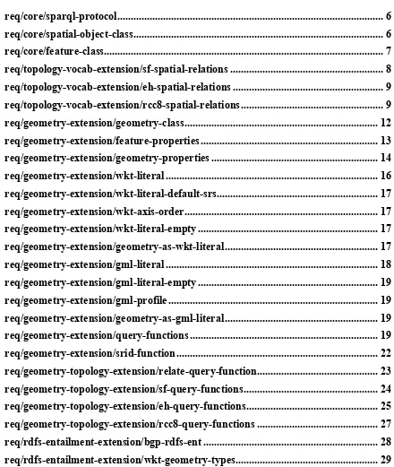
req/core/sparql-protocol ... 6
req/core/spatial-object-class ... 6
req/core/feature-class ... 7
req/topology-vocab-extension/sf-spatial-relations ... 8
req/topology-vocab-extension/eh-spatial-relations ... 9
req/topology-vocab-extension/rcc8-spatial-relations ... 9
req/geometry-extension/geometry-class ... 12
req/geometry-extension/feature-properties ... 13
req/geometry-extension/geometry-properties ... 14
req/geometry-extension/wkt-literal ... 16
req/geometry-extension/wkt-literal-default-srs ... 17
req/geometry-extension/wkt-axis-order ... 17
req/geometry-extension/wkt-literal-empty ... 17
req/geometry-extension/geometry-as-wkt-literal ... 17
req/geometry-extension/gml-literal ... 18
req/geometry-extension/gml-literal-empty ... 19
req/geometry-extension/gml-profile ... 19
req/geometry-extension/geometry-as-gml-literal ... 19
req/geometry-extension/query-functions ... 19
req/geometry-extension/srid-function ... 22
req/geometry-topology-extension/relate-query-function ... 23
req/geometry-topology-extension/sf-query-functions ... 24
req/geometry-topology-extension/eh-query-functions ... 25
req/geometry-topology-extension/rcc8-query-functions ... 27
req/rdfs-entailment-extension/bgp-rdfs-ent ... 28
OGC 11-052r4
x Copyright © 2012 Open Geospatial Consortium
req/rdfs-entailment-extension/gml-geometry-types ... 29
req/query-rewrite-extension/sf-query-rewrite ... 31
req/query-rewrite-extension/eh-query-rewrite ... 32
OGC 11-052r4
Copyright © 2012 Open Geospatial Consortium
xi
i.
Preface
This standard defines a set of SPARQL extension functions [W3C SPARQL], a set of RIF rules [W3C RIF Core], and a core RDF/OWL [12,14,16] vocabulary for geographic information based on the General Feature Model [7], Simple Features [ISO 19125-1], Feature Geometry [6] and SQL MM [4].
ii.
Submitting organizations
The following organizations submitted this Implementation Specification to the Open Geospatial Consortium Inc.:
a) Australian Bureau of Meteorology
b) Bentley Systems, Inc.
c) CSIRO
d) Defence Geospatial Information Working Group (DGIWG)
e) GeoConnections - Natural Resources Canada
f) Interactive Instruments GmbH
g) Oracle America
h) Ordnance Survey
i) Raytheon Company
j) Traverse Technologies, Inc.
OGC 11-052r4
xii Copyright © 2012 Open Geospatial Consortium
iii.
Submission contact points
All questions regarding this submission should be directed to the editor or the submitters:
CONTACT COMPANY
Matthew Perry Oracle America John Herring Oracle
America
iv.
Revision history
Date Release Author Paragraph modified
Description
27 Oct. 2009 Draft Matthew Perry
Clause 6 Technical Draft
11 Nov. 2009 Draft John R.
30 March 2010 Draft Matthew Perry
All Comment responses
26 Oct. 2010 Draft Matthew Perry
All Revision based on working group discussion
28 Jan. 2011 Draft Matthew Perry
All Revision based on working group discussion
18 April 2011 Draft Matthew Perry
All Restructure with multiple conformance classes
02 May 2011 Draft Matthew Perry
Clause 6 and Clause 8
Move Geometry Class from core to geometryExtension
05 May 2011 Draft Matthew Perry
OGC 11-052r4
Copyright © 2012 Open Geospatial Consortium
xiii 13 Jan. 2012 Draft Matthew
Perry
All Revision based on Public RFC
16 April 2012 Draft Matthew Perry
All Revision based on adoption vote comments
19 July 2012 1.0 Matthew Perry
All Revision of URIs based on OGC Naming Authority recommendations
v.
Changes to the OGC
®Abstract Specification
OGC 11-052r4
xiv Copyright © 2012 Open Geospatial Consortium
Foreword
Attention is drawn to the possibility that some of the elements of this document may be the subject of patent rights. Open Geospatial Consortium shall not be held responsible for identifying any or all such patent rights. However, to date, no such rights have been claimed or identified.
OGC 11-052r4
Copyright © 2012 Open Geospatial Consortium
xv
Introduction
The W3C Semantic Web Activity is defining a collection of technologies that enables a “web of data” where information is easily shared and reused across applications. Some key pieces of this technology stack are the RDF (Resource Description Framework) data model [12,14], the OWL Web Ontology Language [16] and the SPARQL protocol and RDF query language [W3C SPARQL].
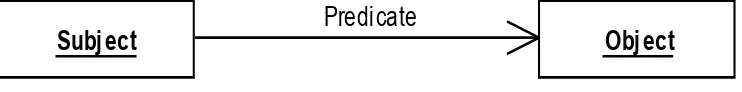
RDF is, among other things, a data model built on edge-node "graphs." Each link in a graph consists of three things (with many aliases depending on the mapping from other types of data models):
Subject (start node, instance, entity, feature)
Predicate (verb, property, attribute, relation, member, link, reference)
Object (value, end node, non-literal values can be used as a Subject)
Any of the three values in a single triple can be represented via a URI (with an optional fragment identifier). Subjects and objects are called nodes and can be represented as a blank node (usually with a local identifier with no meaning). Objects can also be represented as a literal value. Note that the same node may play the role of a Subject in some edges, and the role of the Object in others.
Figure 1: RDF Triple
Almost all data can be presented or represented in RDF. In particular, it is an easy match to the (feature-instance-by-id, attribute, value) tuples of the General Feature Model [7], and for the relational model as (table primary key, column, value).
From http://dbpedia.org/page/SPARQL:
SPARQL is an RDF query language; its name is a recursive acronym that stands for SPARQL Protocol and RDF Query Language. It was standardized by the RDF Data Access Working Group (DAWG) of the World Wide Web Consortium, and is considered a key semantic web technology. On 15 January 2008, SPARQL became
Subject
Object
OGC 11-052r4
xvi Copyright © 2012 Open Geospatial Consortium
an official W3C Recommendation. SPARQL allows [a] query to consist of triple patterns, conjunctions, disjunctions, and optional patterns.
SPARQL queries work on RDF representations of data by finding patterns that match templates in the query, in effect finding information graphs in the RDF data based on the templates and filters (constraints on nodes and edges) expressed in the query. This query template is represented in the SPARQL query by a set of parameterized “query variables” appearing in a sequence of RDF triples and filters. If the query processor finds a set of triples in the data (converted to an RDF graph in some predetermined standard manner) then the values that the “query variables” take on in those triples become a solution to the query request. The values of the variables are returned in the query result in a format based on the “SELECT” clause of the query (similar to SQL).
In addition to predicates defined in this manner, the SPARQL query may contain filter functions that can be used to further constrain the query. Several mechanisms are available to extend filter functions to allow for predicates calculated directly on data values. The SPARQL specification [W3C SPARQL] in section 11.6
(http://www.w3.org/TR/rdf-sparql-query/#extensionFunctions) describes the mechanism for invocation of such a filter function.
The OGC GeoSPARQL standard supports representing and querying geospatial data on the Semantic Web. GeoSPARQL defines a vocabulary for representing geospatial data in RDF, and it defines an extension to the SPARQL query language for processing
geospatial data.
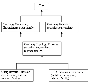
The GeoSPARQL standard follows a modular design; it comprises several different components.
A core component defines top-level RDFS/OWL classes for spatial objects.
A topology vocabulary component defines RDF properties for asserting and
querying topological relations between spatial objects.
A geometry component defines RDFS data types for serializing geometry data,
geometry-related RDF properties, and non-topological spatial query functions for geometry objects.
A geometry topology component defines topological query functions.
An RDFS entailment component defines a mechanism for matching implicit RDF
triples that are derived based on RDF and RDFS semantics.
A query rewrite component defines rules for transforming a simple triple pattern
OGC 11-052r4
Copyright © 2012 Open Geospatial Consortium
xvii Each of the components described above forms a requirements class for GeoSPARQL. Implementations can provide various levels of functionality by choosing which
requirements classes to support. For example, a system based purely on qualitative spatial reasoning may support only the core and topological vocabulary components.
In addition, GeoSPARQL is designed to accommodate systems based on qualitative spatial reasoning and systems based on quantitative spatial computations. Systems based on qualitative spatial reasoning, (e.g. those based on the Region Connection Calculus [1, 9]) do not usually model explicit geometries, so queries in such systems will likely test for binary spatial relationships between features rather than between explicit geometries. To allow queries for spatial relations between features in quantitative systems,
OGC® Standard OGC 11-052r4
Copyright © 2012 Open Geospatial Consortium
1
OGC GeoSPARQL – A Geographic Query Language for RDF
Data
1 Scope
This document defines GeoSPARQL: a spatial extension to the SPARQL query language for geographic information. GeoSPARQL provides the following features:
An RDF/OWL vocabulary for representing spatial information consistent with the Simple Features model
A set of SPARQL extension functions for spatial computations
A set of RIF rules for query transformation
GeoSPARQL does not define a comprehensive vocabulary for representing spatial information. It instead defines a core set of classes, properties and datatypes that can be used to construct query patterns. Many useful extensions to this vocabulary are possible, and we intend for the GIS community to develop additional vocabulary for describing spatial information. Other standards groups are actively working to develop such a vocabulary (e.g. ISO/TC 211).
2 Conformance
Conformance with this specification shall be checked using all the relevant tests specified in Annex A (normative). The framework, concepts, and methodology for testing, and the criteria to be achieved to claim conformance are specified in ISO 19105: Geographic information — Conformance and Testing [5].
This document establishes several requirements classes and corresponding conformance classes. Any GeoSPARQL implementation claiming conformance with one of the conformance classes shall pass all the tests in the associated abstract test suite. Requirements and conformance test URIs defined in this document are relative to
http://www.opengis.net/spec/geosparql/1.0/. Table 1 summarizes the conformance classes in GeoSPARQL. Many conformance classes are parameterized. For parameterized conformance classes, the list of parameters is given within parenthesis.
Table 1 -- Conformance Classes
OGC 11-052r4
2 Copyright © 2012 Open Geospatial Consortium
Core Defines top-level spatial
vocabulary components
topological query functions A.3
Defines a mechanism for matching implicit RDF triples that are derived based on RDF and RDFS based on their associated geometries
A.6
OGC 11-052r4
Copyright © 2012 Open Geospatial Consortium
3 Figure 2: Requirements Class Dependency Graph
3 Normative references
The following normative documents contain provisions which, through reference in this text, constitute provisions of this document. For dated references, subsequent
amendments to, or revisions of, any of these publications do not apply. However, parties to agreements based on this document are encouraged to investigate the possibility of applying the most recent editions of the normative documents indicated below. For undated references, the latest edition of the normative document referred to applies.
ISO 19125-1, Geographic information — Simple feature access — Part 1: Common architecture
OGC 07-036, Geography Markup Language (GML) Encoding Standard, Version 3.2.1
RFC 2396, RFC 2396 - Uniform Resource Identifiers (URI): Generic Syntax Core
Topology Vocabulary Extension (relation_family)
Geometry Extension (serialization, version)
Geometry Topology Extension (serialization, version,
relation_family)
Query Rewrite Extension (serialization, version, relation_family)
OGC 11-052r4
4 Copyright © 2012 Open Geospatial Consortium
W3C RIF Core, RIF Core Dialect,W3C Recommendation (22 June 2010)
W3C SPARQL, SPARQL Query Language for RDF, W3C Recommendation (15 January 2008)
W3C SPARQL Entailment, SPARQL 1.1 Entailment Regimes, W3C Recommendation
W3C SPARQL Protocol, SPARQL Protocol for RDF, W3C Recommendation (15 January 2008)
W3C SPARQL Result Format, SPARQL Query Results XML Format, W3C Recommendation (15 January 2008)
4 Terms and definitions
For the purposes of this document, the terms and definitions given in the above references apply.
5 Conventions
5.1 Symbols (and abbreviated terms)
In this draft candidate standard, the following common acronyms are used:
GeoJSON Geographic JavaScript Object Notation
GFM General Feature Model (as defined in ISO 19109)
GML Geography Markup Language
KML Keyhole Markup Language
OWL OWL 2 Web Ontology Language
RCC Region Connection Calculus
RDF Resource Description Framework
RDFS RDF Schema
RIF Rule Interchange Format
SPARQL SPARQL Protocol and RDF Query Language
WKT Well Known Text (as defined by Simple Features or ISO 19125)
OGC 11-052r4
Copyright © 2012 Open Geospatial Consortium
5 XML Extensible Markup Language
5.2 XML Namespaces
The following XML namespace prefixes are used throughout this document.
ogc: http://www.opengis.net/
geo: http://www.opengis.net/ont/geosparql#
geof: http://www.opengis.net/def/function/geosparql/ geor: http://www.opengis.net/def/rule/geosparql/ sf: http://www.opengis.net/ont/sf#
gml: http://www.opengis.net/ont/gml# my: http://example.org/ApplicationSchema# xsd: http://www.w3.org/2001/XMLSchema# rdf: http://www.w3.org/1999/02/22-rdf-syntax-ns# rdfs: http://www.w3.org/2000/01/rdf-schema# owl: http://www.w3.org/2002/07/owl#
5.3 Placeholder URIs
The URI ogc:geomLiteral is used in requirement specifications as a placeholder for the geometry literal serialization used in a fully-qualified conformance class, e.g.
<http://www.opengis.net/ont/geosparql#wktLiteral>.
The URI ogc:asGeomLiteral is used in requirement specifications as a placeholder for the geometry literal serialization property used in a fully-qualified conformance class, e.g. geo:asWKT.
5.4 RDF Serializations
OGC 11-052r4
6 Copyright © 2012 Open Geospatial Consortium
6 Core
This clause establishes the core requirements class, with URI /req/core, which has a single corresponding conformance class, core, with URI /conf/core. This
requirements class defines a set of classes and properties for representing geospatial data. The resulting vocabulary can be used to construct SPARQL graph patterns for querying appropriately modeled geospatial data. RDFS and OWL vocabulary have both been used so that the vocabulary can be understood by systems that support only RDFS entailment and by systems that support OWL-based reasoning.
6.1 SPARQL
Req 1 Implementations shall support the SPARQL Query Language for RDF [W3C SPARQL], the SPARQL Protocol for RDF [W3C SPARQL Protocol] and the SPARQL Query Results XML Format [W3C SPARQL Result Format].
/req/core/sparql-protocol
6.2 Classes
Two main classes are defined: geo:SpatialObject and geo:Feature. The class
geo:Feature is equivalent to the UML class GFI_Feature defined in [8].
6.2.1 Class: geo:SpatialObject
The class geo:SpatialObject is defined by the following:
geo:SpatialObject a rdfs:Class, owl:Class;
rdfs:isDefinedBy <http://www.opengis.net/spec/geosparql/1.0>; rdfs:label "Spatial Object"@en;
rdfs:comment "The class Spatial Object represents everything that can have a spatial representation. It is superclass of feature and geometry"@en .
Req 2 Implementations shall allow the RDFS class geo:SpatialObject to be used in SPARQL graph patterns.
/req/core/spatial-object-class
6.2.2 Class: geo:Feature
The class geo:Feature is equivalent to the class GFI_Feature [8] and is defined by the following:
OGC 11-052r4
Copyright © 2012 Open Geospatial Consortium
7
owl:Class;
rdfs:isDefinedBy <http://www.opengis.net/spec/geosparql/1.0>; rdfs:label "Feature"@en;
rdfs:subClassOf geo:SpatialObject; owl:disjointWith geo:Geometry;
rdfs:comment "This class represents the top-level feature type. This class is equivalent to GFI_Feature defined in ISO 19156, and it is superclass of all feature types."@en .
Req 3 Implementations shall allow the RDFS class geo:Feature to be used in SPARQL graph patterns.
/req/core/feature-class
7 Topology Vocabulary Extension (relation_family)
This clause establishes the Topology Vocabulary Extension (relation_family)
parameterized requirements class, with URI /req/topology-vocab-extension, which has a single corresponding conformance class Topology Vocabulary Extension
(relation_family), with URI /conf/topology-vocab-extension. This requirements
class defines a vocabulary for asserting and querying topological relations between spatial objects. The class is parameterized so that different families of topological
relations may be used, e.g. RCC8, Egenhofer. These relations are generalized so that they may connect features as well as geometries.
A DE-9IM pattern, which specifies the spatial dimension of the intersections of the interiors, boundaries and exteriors of two geometric objects, is used to describe each spatial relation. Possible pattern values are -1 (empty), 0, 1, 2, T (true) = {0, 1, 2}, F
(false) = {-1}, * (don’t care) = {-1, 0, 1, 2}. In the following descriptions, the notation X/Y is used denote applying a spatial relation to geometry types X and Y (i.e., x
relationy where x is of type X and y is of type Y). The symbol P is used for
0-dimensional geometries (e.g. points). The symbol L is used for 1-dimensional geometries (e.g. lines), and the symbol A is used for 2-dimensional geometries (e.g. polygons). Consult the Simple Features specification [ISO 19125-1] for a more detailed description of DE-9IM intersection patterns.
7.1 Parameters
The following parameter is defined for the Topology Vocabulary Extension requirements class.
OGC 11-052r4
8 Copyright © 2012 Open Geospatial Consortium
7.2 Requirements for Simple Features Relation Family (relation_family=Simple Features)
This clause defines requirements for the Simple Features relation family.
Req 4 Implementations shall allow the properties geo:sfEquals, geo:sfDisjoint,
geo:sfIntersects, geo:sfTouches, geo:sfCrosses, geo:sfWithin,
geo:sfContains, geo:sfOverlaps to be used in SPARQL graph patterns.
/req/topology-vocab-extension/sf-spatial-relations
Topological relations in the Simple Features family are summarized in Table 1. Multi-row intersection patterns should be interpreted as a logical OR of each row.
Table 1– Simple Features Topological Relations
Relation Name
Relation URI Domain/Range Applies To Geometry
Types
DE-9IM Intersection
Pattern
equals geo:sfEquals geo:SpatialObject All (TFFFTFFFT)
disjoint geo:sfDisjoint geo:SpatialObject All (FF*FF****)
intersects geo:sfIntersects geo:SpatialObject All (T******** *T******* ***T***** ****T****)
touches geo:sfTouches geo:SpatialObject All except P/P
(FT******* F**T***** F***T****)
within geo:sfWithin geo:SpatialObject All (T*F**F***)
contains geo:sfContains geo:SpatialObject All (T*****FF*)
overlaps geo:sfOverlaps geo:SpatialObject A/A, P/P, L/L
(T*T***T**) for A/A, P/P; (1*T***T**) for L/L
crosses geo:sfCrosses geo:SpatialObject P/L, P/A, L/A, L/L
7.3 Requirements for Egenhofer Relation Family (relation_family=Egenhofer)
OGC 11-052r4
Copyright © 2012 Open Geospatial Consortium
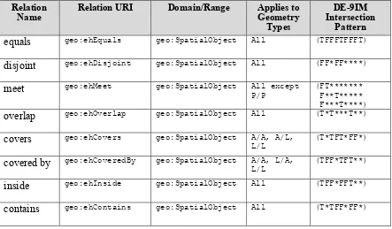
9 Req 5 Implementations shall allow the properties geo:ehEquals, geo:ehDisjoint,
geo:ehMeet, geo:ehOverlap, geo:ehCovers, geo:ehCoveredBy,
geo:ehInside, geo:ehContains to be used in SPARQL graph patterns.
/req/topology-vocab-extension/eh-spatial-relations
Topological relations in the Egenhofer family are summarized in Table 2. Multi-row intersection patterns should be interpreted as a logical OR of each row.
Table 2– Egenhofer Topological Relations
Relation Name
Relation URI Domain/Range Applies to Geometry
Types
DE-9IM Intersection
Pattern
equals geo:ehEquals geo:SpatialObject All (TFFFTFFFT)
disjoint geo:ehDisjoint geo:SpatialObject All (FF*FF****)
meet geo:ehMeet geo:SpatialObject All except P/P
(FT******* F**T***** F***T****)
overlap geo:ehOverlap geo:SpatialObject All (T*T***T**)
covers geo:ehCovers geo:SpatialObject A/A, A/L, L/L
(T*TFT*FF*)
covered by geo:ehCoveredBy geo:SpatialObject A/A, L/A, L/L
(TFF*TFT**)
inside geo:ehInside geo:SpatialObject All (TFF*FFT**)
contains geo:ehContains geo:SpatialObject All (T*TFF*FF*)
7.4 Requirements for RCC8 Relation Family (relation_family=RCC8)
This clause defines requirements for the RCC8 relation family. Consult references [1] and [9] for a more detailed discussion of RCC8 relations.
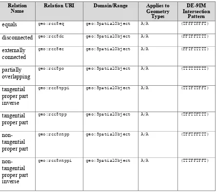
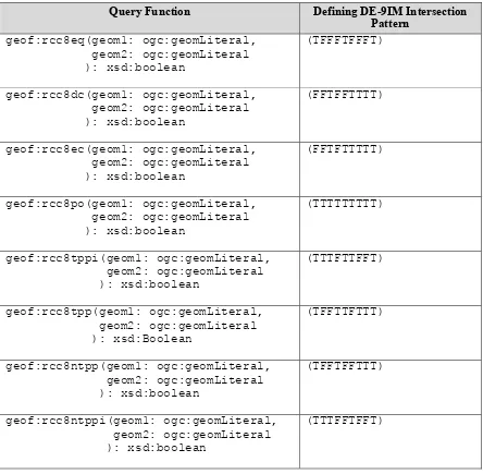
Req 6 Implementations shall allow the properties geo:rcc8eq, geo:rcc8dc,
geo:rcc8ec, geo:rcc8po, geo:rcc8tppi, geo:rcc8tpp, geo:rcc8ntpp,
geo:rcc8ntppi to be used in SPARQL graph patterns.
OGC 11-052r4
10 Copyright © 2012 Open Geospatial Consortium
Topological relations in the RCC8 family are summarized in Table 3.
Table 3– RCC8 Topological Relations
Relation Name
Relation URI Domain/Range Applies to Geometry Types
DE-9IM Intersection
Pattern
equals geo:rcc8eq geo:SpatialObject A/A (TFFFTFFFT)
disconnected geo:rcc8dc geo:SpatialObject A/A (FFTFFTTTT)
externally connected
geo:rcc8ec geo:SpatialObject A/A (FFTFTTTTT)
partially overlapping
geo:rcc8po geo:SpatialObject A/A (TTTTTTTTT)
tangential proper part inverse
geo:rcc8tppi geo:SpatialObject A/A (TTTFTTFFT)
tangential proper part
geo:rcc8tpp geo:SpatialObject A/A (TFFTTFTTT)
non-tangential proper part
geo:rcc8ntpp geo:SpatialObject A/A (TFFTFFTTT)
non-tangential proper part inverse
geo:rcc8ntppi geo:SpatialObject A/A (TTTFFTFFT)
7.5 Equivalent RCC8, Egenhofer and Simple Features Topological Relations
Table 4 summarizes the equivalences between Egenhofer, RCC8 and Simple Features spatial relations for closed, non-empty regions. The symbol + denotes logical OR, and the symbol ¬ denotes negation.
Table 4 -- Equivalent Simple Features, RCC8 and Egenhofer relations
OGC 11-052r4
Copyright © 2012 Open Geospatial Consortium
11
equals equals equal
disjoint disconnected disjoint
intersects ¬ disconnected ¬ disjoint
touches externally connected meet
within non-tangential proper part + tangential proper part
inside + coveredBy
contains non-tangential proper part inverse + tangential proper part inverse
contains + covers
overlaps partially overlapping overlap
8 Geometry Extension (serialization, version)
This clause establishes the Geometry Extension (serialization, version) parameterized requirements class, with URI /req/geometry-extension, which has a single
corresponding conformance class Geometry Extension (serialization, version), with URI
/conf/geometry-extension. This requirements class defines a vocabulary for asserting and querying information about geometry data, and it defines query functions for operating on geometry data.
As part of the vocabulary, an RDFS datatype is defined for encoding detailed geometry information as a literal value. A literal representation of a geometry is needed so that geometric values may be treated as a single unit. Such a representation allows geometries to be passed to external functions for computations and to be returned from a query.
Other schemes for encoding simple geometry data in RDF have been proposed. The W3C Basic Geo vocabulary (http://www.w3.org/2003/01/geo/) is one popular vocabulary. These simple vocabularies have limitations, for example the inability to specify different datums and coordinate systems, and were therefore not used in GeoSPARQL. Note that most existing geometry data encoded using these vocabularies can easily be converted into GeoSPARQL representations. The SPARQL query below creates geo:wktLiteral
values from W3C Basic Geo geometries.
PREFIX w3cGeo: <http://www.w3.org/2003/01/geo/wgs84_pos#> PREFIX geo: <http://www.opengis.net/#geosparql>
SELECT (STRDT(CONCAT("POINT(",?long," ",?lat,")"), geo:wktLiteral) AS ?wktLit)
OGC 11-052r4
12 Copyright © 2012 Open Geospatial Consortium
8.1 Parameters
The following parameters are defined for the Geometry Extension requirements class.
serialization: Specifies the serialization standard to use when generating geometry literals and also the supported geometry types.
Note that the serialization chosen strongly affects the geometry conceptualization. The WKT serialization aligns the geometry types with ISO 19125 Simple Features [ISO 19125-1], and the GML serialization aligns the geometry types with ISO 19107 Spatial Schema [6].
version: Specifies the version of the serialization format used.
8.2 Geometry Classes and Properties
A single root geometry class is defined: geo:Geometry. The class geo:Geometry is equivalent to the UML class GM_Object defined in [6]. In addition, properties are defined for describing geometry data and for associating geometries with features.
8.2.1 Class: geo:Geometry
The class geo:Geometry is equivalent to GM_Object [6] and is defined by the following:
geo:Geometry a rdfs:Class, owl:Class;
rdfs:isDefinedBy <http://www.opengis.net/spec/geosparql/1.0>; rdfs:label "Geometry"@en;
rdfs:subClassOf geo:SpatialObject; owl:disjointWith geo:Feature;
rdfs:comment "The class represents the top-level geometry type. This class is equivalent to the UML class GM_Object defined in ISO 19107, and it is superclass of all geometry types."@en .
Req 7 Implementations shall allow the RDFS class geo:Geometry to be used in SPARQL graph patterns.
/req/geometry-extension/geometry-class
8.3 Standard Properties for geo:Feature
Properties are defined for associating geometries with features.
Req 8 Implementations shall allow the properties geo:hasGeometry and
OGC 11-052r4
Copyright © 2012 Open Geospatial Consortium
13
/req/geometry-extension/feature-properties
8.3.1.1 Property: geo:hasGeometry
The property geo:hasGeometry is used to link a feature with a geometry that represents its spatial extent. A given feature may have many associated geometries.
geo:hasGeometry a rdf:Property, owl:ObjectProperty;
rdfs:isDefinedBy <http://www.opengis.net/spec/geosparql/1.0>; rdfs:label "has Geometry"@en;
rdfs:comment "A spatial representation for a given feature."@en; rdfs:domain geo:Feature;
rdfs:range geo:Geometry .
8.3.1.2 Property: geo:hasDefaultGeometry
The property geo:hasDefaultGeometry is used to link a feature with its default geometry. The default geometry is the geometry that should be used for spatial
calculations in the absence of a request for a specific geometry (e.g. in the case of query rewrite).
geo:hasDefaultGeometry a rdf:Property, owl:ObjectProperty;
rdfs:isDefinedBy <http://www.opengis.net/spec/geosparql/1.0>; rdfs:label "has Default Geometry"@en;
rdfs:comment "The default geometry to be used in spatial calculations, usually the most detailed geometry."@en;
rdfs:subPropertyOf geo:hasGeometry; rdfs:domain geo:Feature; rdfs:range geo:Geometry .
GeoSPARQL does not restrict the cardinality of the geo:hasDefaultGeometry
property. It is thus possible for a feature to have more than one distinct default geometry or to have no default geometry. This situation does not result in a query processing error; SPARQL graph pattern matching simply proceeds as normal. Certain queries may, however, give logically inconsistent results. For example, if a feature my:f1 has two asserted default geometries, and those two geometries are disjoint polygons, the query below could return a non-zero count on a system supporting the GeoSPARQL Query Rewrite Extension (rule geor:sfDisjoint).
PREFIX geo: <http://www.opengis.net/ont/geosparql#>
SELECT (COUNT(*) AS ?cnt)
OGC 11-052r4
14 Copyright © 2012 Open Geospatial Consortium
Such cases are application-specific data modeling errors and are therefore outside of the scope of the GeoSPARQL specification.
8.4 Standard Properties for geo:Geometry
Properties are defined for describing geometry metadata.
Req 9 Implementations shall allow the properties geo:dimension,
geo:coordinateDimension, geo:spatialDimension, geo:isEmpty,
geo:isSimple, geo:hasSerialization to be used in SPARQL graph patterns.
/req/geometry-extension/geometry-properties
8.4.1 Property: geo:dimension
The dimension is the topological dimension of this geometric object, which must be less than or equal to the coordinate dimension. In non-homogeneous collections, this will return the largest topological dimension of the contained objects.
geo:dimension a rdf:Property,
owl:DatatypeProperty;
rdfs:isDefinedBy <http://www.opengis.net/spec/geosparql/1.0>; rdfs:label "dimension"@en;
rdfs:comment "The topological dimension of this geometric object, which must be less than or equal to the coordinate dimension. In non-homogeneous collections, this is the largest
topological dimension of the contained objects."@en; rdfs:domain geo:Geometry;
rdfs:range xsd:integer .
8.4.2 Property: geo:coordinateDimension
The coordinate dimension is the dimension of direct positions (coordinate tuples) used in the definition of this geometric object.
geo:coordinateDimension a rdf:Property,
owl:DatatypeProperty;
rdfs:isDefinedBy <http://www.opengis.net/spec/geosparql/1.0>; rdfs:label "coordinate dimension"@en;
rdfs:comment "The number of measurements or axes needed to describe the position of this geometry in a coordinate system."@en; rdfs:domain geo:Geometry;
OGC 11-052r4
Copyright © 2012 Open Geospatial Consortium
15 8.4.3 Property: geo:spatialDimension
The spatial dimension is the dimension of the spatial portion of the direct positions (coordinate tuples) used in the definition of this geometric object. If the direct positions do not carry a measure coordinate, this will be equal to the coordinate dimension.
geo:spatialDimension a rdf:Property,
owl:DatatypeProperty;
rdfs:isDefinedBy <http://www.opengis.net/spec/geosparql/1.0>; rdfs:label "coordinate dimension"@en;
rdfs:comment "The number of measurements or axes needed to describe the spatial position of this geometry in a coordinate
system."@en; rdfs:domain geo:Geometry; rdfs:range xsd:integer .
8.4.4 Property: geo:isEmpty
The geo:isEmpty Boolean will be set to true only if the geometry contains no points.
geo:isEmpty a rdf:Property,
owl:DatatypePropterty;
rdfs:isDefinedBy <http://www.opengis.net/spec/geosparql/1.0>; rdfs:label "is empty"@en;
rdfs:comment "(true) if this geometric object is the empty Geometry. If true, then this geometric object represents the empty point set for the coordinate space."@en;
rdfs:domain geo:Geometry; rdfs:range xsd:boolean .
8.4.5 Property: geo:isSimple
The geo:isSimple Boolean will be set to true, only if the geometry contains no self-intersections, with the possible exception of its boundary.
geo:isSimple a rdf:Property,
owl:DatatypePropterty;
rdfs:isDefinedBy <http://www.opengis.net/spec/geosparql/1.0>; rdfs:label "is simple"@en;
rdfs:comment "(true) if this geometric object has no anomalous geometric points, such as self intersection or self tangency."@en; rdfs:domain geo:Geometry;
rdfs:range xsd:boolean .
8.4.6 Property: geo:hasSerialization
OGC 11-052r4
16 Copyright © 2012 Open Geospatial Consortium
geo:hasSerialization a rdf:Property,
owl:DatatypePropterty;
rdfs:isDefinedBy <http://www.opengis.net/spec/geosparql/1.0>; rdfs:label "has serialization"@en;
rdfs:comment "Connects a geometry object with its text-based serialization."@en;
rdfs:domain geo:Geometry; rdfs:range rdfs:Literal .
8.5 Requirements for WKT Serialization (serialization=WKT)
This section establishes the requirements for representing geometry data in RDF based on WKT as defined by Simple Features [ISO 19125-1].
8.5.1 RDFS Datatypes
This section defines one RDFS Datatype:
http://www.opengis.net/ont/geosparql#wktLiteral.
RDFS Datatype: geo:wktLiteral
geo:wktLiteral a rdfs:Datatype;
rdfs:isDefinedBy <http://www.opengis.net/spec/geosparql/1.0>; rdfs:label "Well-known Text Literal"@en;
rdfs:comment "A Well-known Text serialization of a geometry object."@en .
Req 10 All RDFS Literals of type geo:wktLiteral shall consist of an optional URI identifying the coordinate reference system followed by Simple Features Well Known Text (WKT) describing a geometric value. Valid geo:wktLiterals are formed by concatenating a valid, absolute URI as defined in [RFC 2396], one or more spaces (Unicode U+0020 character) as a separator, and a WKT string as defined in Simple Features [ISO 19125-1].
/req/geometry-extension/wkt-literal
For geo:wktLiterals, the beginning URI identifies the spatial reference system for the geometry. The OGC maintains a set of CRS URIs under the
http://www.opengis.net/def/crs/ namespace. This leading spatial reference system URI is optional. In the absence of a leading spatial reference system URI, the following spatial reference system URI will be assumed:
<http://www.opengis.net/def/crs/OGC/1.3/CRS84>
This URI denotes WGS 84 longitude-latitude.
OGC 11-052r4
Copyright © 2012 Open Geospatial Consortium
17 an explicit spatial reference system URI.
/req/geometry-extension/wkt-literal-default-srs
Req 12 Coordinate tuples within geo:wktLiterals shall be interpreted using the axis order defined in the spatial reference system used.
/req/geometry-extension/wkt-axis-order
The example geo:wktLiteral below encodes a point geometry using the default WGS 84 geodetic longitude-latitude spatial reference system for Simple Features 1.0:
"Point(-83.38 33.95)"^^<http://www.opengis.net/ont/geosparql#wktLiteral>
A second example below encodes the same point using
<http://www.opengis.net/def/crs/EPSG/0/4326>: a WGS 84 geodetic
latitude-longitude spatial reference system (note that this spatial reference system defines a different axis order):
"<http://www.opengis.net/def/crs/EPSG/0/4326>
Point(33.95 -83.38)"^^<http://www.opengis.net/ont/geosparql#wktLiteral>
Req 13 An empty RDFS Literal of type geo:wktLiteral shall be interpreted as an empty geometry.
/req/geometry-extension/wkt-literal-empty
8.5.2 Serialization Properties
The geo:asWKT property is defined to link a geometry with its WKT serialization.
Property: geo:asWKT
Req 14 Implementations shall allow the RDF property geo:asWKT to be used in SPARQL graph patterns.
/req/geometry-extension/geometry-as-wkt-literal
The property geo:asWKT is used to link a geometric element with its WKT serialization.
OGC 11-052r4
18 Copyright © 2012 Open Geospatial Consortium
owl:DatatypeProperty;
rdfs:subPropertyOf geo:hasSerialization;
rdfs:isDefinedBy <http://www.opengis.net/spec/geosparql/1.0>; rdfs:label "as WKT"@en;
rdfs:comment "The WKT serialization of a geometry."@en; rdfs:domain geo:Geometry;
rdfs:range geo:wktLiteral .
8.6 Requirements for GML Serialization (serialization=GML)
This section establishes requirements for representing geometry data in RDF based on GML as defined by Geography Markup Language Encoding Standard [OGC 07-036].
8.6.1 RDFS Datatypes
This section defines one RDFS Datatype:
http://www.opengis.net/ont/geosparql#gmlLiteral.
RDFS Datatype: geo:gmlLiteral
geo:gmlLiteral a rdfs:Datatype;
rdfs:isDefinedBy <http://www.opengis.net/spec/geosparql/1.0>; rdfs:label "GML literal"@en;
rdfs:comment "The datatype of GML literal values"@en .
Valid geo:gmlLiterals are formed by encoding geometry information as a valid element from the GML schema that implements a subtype of GM_Object. For example, in GML 3.2.1 this is every element directly or indirectly in the substitution group of the element {http://www.opengis.net/ont/gml/3.2}AbstractGeometry. In GML 3.1.1 and GML 2.1.2 this is every element directly or indirectly in the substitution group of the element {http://www.opengis.net/ont/gml}_Geometry.
Req 15 All geo:gmlLiterals shall consist of a valid element from the GML schema that implements a subtype of GM_Object as defined in [OGC 07-036].
/req/geometry-extension/gml-literal
The example geo:gmlLiteral below encodes a point geometry in the WGS 84 geodetic longitude-latitude spatial reference system using GML version 3.2:
"<gml:Point
srsName=\"http://www.opengis.net/def/crs/OGC/1.3/CRS84\" xmlns:gml=\"http://www.opengis.net/ont/gml\">
<gml:pos>-83.38 33.95</gml:pos>
OGC 11-052r4
Copyright © 2012 Open Geospatial Consortium
19 Req 16 An empty geo:gmlLiteral shall be interpreted as an empty geometry.
/req/geometry-extension/gml-literal-empty
Req 17 Implementations shall document supported GML profiles.
/req/geometry-extension/gml-profile
8.6.2 Serialization Properties
This document defines the geo:asGML property to link a geometry with its serialization.
Property: geo:asGML
Req 18 Implementations shall allow the RDF property geo:asGML to be used in SPARQL graph patterns.
/req/geometry-extension/geometry-as-gml-literal
The property geo:asGML is used to link a geometric element with its GML serialization.
geo:asGML a rdf:Property;
rdfs:subPropertyOf geo:hasSerialization;
rdfs:isDefinedBy <http://www.opengis.net/spec/geosparql/1.0>; rdfs:label "as GML"@en;
rdfs:comment "The GML serialization of a geometry."@en; rdfs:domain geo:Geometry;
rdfs:range geo:gmlLiteral .
8.7 Non-topological Query Functions
This clause defines SPARQL functions for performing non-topological spatial operations.
Req 19 Implementations shall support geof:distance, geof:buffer,
geof:convexHull, geof:intersection, geof:union, geof:difference,
geof:symDifference, geof:envelope and geof:boundary as SPARQL extension functions, consistent with the definitions of the corresponding functions (distance, buffer, convexHull, intersection, difference,
symDifference, envelope and boundary respectively) in Simple Features [ISO 19125-1].
OGC 11-052r4
20 Copyright © 2012 Open Geospatial Consortium
An invocation of any of the following functions with invalid arguments produces an error. An invalid argument includes any of the following:
An argument of an unexpected type
An invalid geometry literal value
A geometry literal from a spatial reference system that is incompatible with the spatial reference system used for calculations
An invalid units URI
For further discussion of the effects of errors during FILTER evaluation, consult Section 11 of the SPARQL specification [W3C SPARQL] (http://www.w3.org/TR/rdf-sparql-query/#tests).
Note that returning values instead of raising an error serves as an extension mechanism of SPARQL.
From Section 11.3.1 of the SPARQL specification [W3C SPARQL] (http://www.w3.org/TR/rdf-sparql-query/#operatorExtensibility):
SPARQL language extensions may provide additional associations between operators and operator functions; this amounts to adding rows to the table above. No additional operator may yield a result that replaces any result other than a type error in the semantics defined above. The consequence of this rule is that SPARQL extensions will produce at least the same solutions as an unextended implementation, and may, for some queries, produce more solutions.
This extension mechanism is intended to allow GeoSPARQL implementations to simultaneously support multiple geometry serializations. For example, a system that supports geo:wktLiteral serializations may also support geo:gmlLiteral
serializations and consequently would not raise an error if it encounters multiple geometry datatypes while processing a given query.
Several non-topological query functions use a unit of measure URI. The OGC has defined some standard units of measure URIs under the
http://www.opengis.net/def/uom/OGC/1.0/ namespace, for example
<http://www.opengis.net/def/uom/OGC/1.0/metre>.
8.7.1 Function: geof:distance
OGC 11-052r4
Copyright © 2012 Open Geospatial Consortium
21 Returns the shortest distance in units between any two Points in the two geometric
objects as calculated in the spatial reference system of geom1.
8.7.2 Function: geof:buffer
geof:buffer (geom: ogc:geomLiteral, radius: xsd:double, units: xsd:anyURI): ogc:geomLiteral
This function returns a geometric object that represents all Points whose distance from
geom1 is less than or equal to the radius measured in units. Calculations are in the spatial reference system of geom1.
8.7.3 Function: geof:convexHull
geof:convexHull (geom1: ogc:geomLiteral): ogc:geomLiteral
This function returns a geometric object that represents all Points in the convex hull of
geom1. Calculations are in the spatial reference system of geom1.
8.7.4 Function: geof:intersection
geof:intersection (geom1: ogc:geomLiteral,
geom2: ogc:geomLiteral): ogc:geomLiteral
This function returns a geometric object that represents all Points in the intersection of
geom1 with geom2. Calculations are in the spatial reference system of geom1.
8.7.5 Function: geof:union
geof:union (geom1: ogc:geomLiteral, geom2: ogc:geomLiteral, ): ogc:geomLiteral
This function returns a geometric object that represents all Points in the union of geom1
with geom2. Calculations are in the spatial reference system of geom1.
8.7.6 Function: geof:difference
geof:difference (geom1: ogc:geomLiteral, geom2: ogc:geomLiteral, ): ogc:geomLiteral
This function returns a geometric object that represents all Points in the set difference of
OGC 11-052r4
22 Copyright © 2012 Open Geospatial Consortium
8.7.7 Function: geof:symDifference
geof:symDifference (geom1: ogc:geomLiteral, geom2: ogc:geomLiteral, ): ogc:geomLiteral
This function returns a geometric object that represents all Points in the set symmetric difference of geom1 with geom2. Calculations are in the spatial reference system of
geom1.
8.7.8 Function: geof:envelope
geof:envelope (geom1: ogc:geomLiteral): ogc:geomLiteral
This function returns the minimum bounding box of geom1. Calculations are in the spatial reference system of geom1.
8.7.9 Function: geof:boundary
geof:boundary (geom1: ogc:geomLiteral): ogc:geomLiteral
This function returns the closure of the boundary of geom1. Calculations are in the spatial reference system of geom1.
Req 20 Implementations shall support geof:getSRID as a SPARQL extension function.
/req/geometry-extension/srid-function
8.7.10 Function: geof:getsrid
geof:getSRID (geom: ogc:geomLiteral): xsd:anyURI
Returns the spatial reference system URI for geom.
9 Geometry Topology Extension (relation_family, serialization, version)
This clause establishes the Geometry Topology Extension (relation_family, serialization,
version) parameterized requirements class, with URI
OGC 11-052r4
Copyright © 2012 Open Geospatial Consortium
23
Extension (relation_family, serialization, version), with URI
/conf/geometry-topology-extension.
The Dimensionally Extended Nine Intersection Model (DE-9IM) has been used to define the relation tested by the query functions introduced in this section. Each query function is associated with a defining DE-9IM intersection pattern. Possible pattern values are -1
(empty), 0, 1, 2, T (true) = {0, 1, 2}, F (false) = {-1}, * (don’t care) = {-1, 0, 1, 2}. In the following descriptions, the notation X/Y is used denote applying a spatial relation to geometry types X and Y (i.e., xrelationy where x is of type X and y is of type Y). The symbol P is used for 0-dimensional geometries (e.g. points). The symbol L is used for 1-dimensional geometries (e.g. lines), and the symbol A is used for 2-dimensional
geometries (e.g. polygons). Consult the Simple Features specification [ISO 19125-1] for a more detailed description of DE-9IM intersection patterns.
9.1 Parameters
relation_family: Specifies the set of topological spatial relations to support.
serialization: Specifies the serialization standard to use for geometry literals.
version: Specifies the version of the serialization format used.
9.2 Common Query Functions
Req 21 Implementations shall support geof:relate as a SPARQL extension function, consistent with the relate operator defined in Simple Features [ISO 19125-1].
/req/geometry-topology-extension/relate-query-function
geof:relate (geom1: ogc:geomLiteral, geom2: ogc:geomLiteral, pattern-matrix: xsd:String): xsd:boolean
Returns true if the spatial relationship between geom1 and geom2 corresponds to one with acceptable values for the specified pattern-matrix. Otherwise, this function returns false. Pattern-matrix represents a DE-9IM intersection pattern consisting of T (true) and F (false) values. The spatial reference system for geom1 is used for spatial calculations.
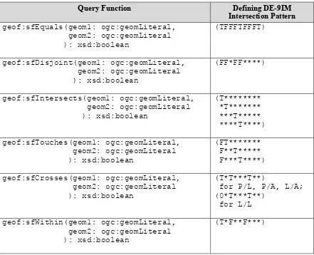
9.3 Requirements for Simple Features Relation Family (relation_family=Simple Features)
This clause establishes requirements for the Simple Features relation family.
OGC 11-052r4
24 Copyright © 2012 Open Geospatial Consortium
geof:sfIntersects, geof:sfTouches, geof:sfCrosses, geof:sfWithin,
geof:sfContains, geof:sfOverlaps as SPARQL extension functions, consistent with their corresponding DE-9IM intersection patterns, as defined by Simple Features [ISO 19125-1].
/req/geometry-topology-extension/sf-query-functions
Boolean query functions defined for the Simple Features relation family, along with their associated DE-9IM intersection patterns, are shown in Table 5 below. Multi-row
intersection patterns should be interpreted as a logical OR of each row. Each function accepts two arguments (geom1 and geom2) of the geometry literal serialization type specified by serialization and version. Each function returns an xsd:boolean value of
true if the specified relation exists between geom1 and geom2 and returns false
otherwise. In each case, the spatial reference system of geom1 is used for spatial calculations.
Table 5 -- Simple Features Query Functions
OGC 11-052r4
Copyright © 2012 Open Geospatial Consortium
25
geof:sfContains(geom1: ogc:geomLiteral, geom2: ogc:geomLiteral ): xsd:boolean
(T*****FF*)
geof:sfOverlaps(geom1: ogc:geomLiteral, geom2: ogc:geomLiteral ): xsd:boolean
(T*T***T**) for A/A, P/P; (1*T***T**) for L/L
9.4 Requirements for Egenhofer Relation Family (relation_family=Egenhofer)
This clause establishes requirements for the Egenhofer relation family. Consult references [2] and [3] for a more detailed discussion of Egenhofer relations.
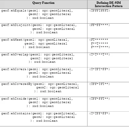
Req 23 Implementations shall support geof:ehEquals, geof:ehDisjoint,
geof:ehMeet, geof:ehOverlap, geof:ehCovers, geof:ehCoveredBy,
geof:ehInside, geof:ehContains as SPARQL extension functions, consistent with their corresponding DE-9IM intersection patterns, as defined by Simple Features [ISO 19125-1].
/req/geometry-topology-extension/eh-query-functions
Boolean query functions defined for the Egenhofer relation family, along with their associated DE-9IM intersection patterns, are shown in Table 6 below. Multi-row intersection patterns should be interpreted as a logical OR of each row. Each function accepts two arguments (geom1 and geom2) of the geometry literal serialization type specified by serialization and version. Each function returns an xsd:boolean value of
true if the specified relation exists between geom1 and geom2 and returns false