REPO
ORT ON C
CHARAC
CTERIZAT
TION OF C
COASTA
AL COMMUNITIES
AND SHO
ORELINE
E ENVIRO
ONMENTS
S IN
THE WE
ESTERN R
REGION O
OF GHAN
NA
INTEGR
RATED CO
OASTAL AN
ND FISHER
RIES GOVE
ERNANCE INITIATIVE
E FOR THE
E
WES
STERN RE
EGION OF G
GHANA
SEPTEM
MBER 2010
Citation: Coastal Resources Center / Friends of the Nation (2010). Report on
Characterization of Coastal Communities and Shoreline Environments in the Western Region of Ghana. Integrated Coastal and Fisheries Governance Initiative for the Western Region of Ghana. Coastal Resources Center, University of Rhode Island,425 pages.
This characterization report was written by these three groups of authors:
1.Stephen Kankam, Godfred Ameyaw, Parnarkie Kusah, Bernard Yankum and Linda Dsane.
Section 3: Rapid Assessment of Coastal Communities in the Western Region: Summary of Findings for Shama District
Section 4: Rapid Assessment of Coastal Communities in the Western Region: Summary of Findings for Sekondi-Takoradi Metropolitan Area (STMA)
2. Nana Efua Tweba Ewur, Richard Adupong, John Dickson Eshun, Patricia Aba Mensah, Justice Nketiah and Balertey Gormey
Section 5: Rapid Assessment of Coastal Communities in the Western Region: Summary of Findings for Ahanta West District
Section 6: Rapid Assessment of Coastal Communities in the Western Region: Summary of Findings for Nzema East Municipal Assembly
3. Elvis Sammy Addae; Randolph Kwesi Benyi Johnson; Solomon Kusi Ampofo; Stephen Donkoh and Balertey Gormey.
Section 7: Rapid Assessment of Coastal Communities in the Western Region: Summary of findings for Ellembelle District.
Section 8: Rapid Assessment of Coastal Communities in the Western Region: Summary of Findings for Jomoro District Assembly
Disclaimer: This publication is made possible by the generous support of the American people through the United States Agency for International Development (USAID)/Ghana. The contents are the responsibility of the authors and do not necessarily reflect the views of the United States Government. Associate Cooperative Agreement No. 641-A-00-09-00036 00 for “Integrated Coastal and Fisheries Governance (ICFG) Program for the Western Region of Ghana”, Under the Leader with Associates Award No. EPP-A-00-04-00014 00.Cooperative Agreement No. GPO-A-00-08-00002-00
Cover photo: Western Region, Ghana
Table of contents
3.0 Rapid Assessment of Coastal Communities in in the Western Region:
Summary of Findings for Shama District
10
Background 10
Profile of Shama District: Brief History of Shama 10
Physical Characteristics 10
Local and traditional governance 11
Demographic Characteristics 11
Economic Activities, Livelihoods and Quality of Life 12
Environment 12
Land Use 13
Key Coastal and Fisheries Issues in Shama District 13
Fisheries Issues 13
Coastal Management Issues 14
Other Development Issues of Concern in Coastal Communities 15
References 15
Appendix 1: List of Key Contacts 16
Appendix 2: Description of Fishing Gears 17
Appendix 3: Description of Fishing Vessels in Shama District 19
Appendix 4: District Validation Workshop Outputs 20
: Stories from the field 24
Appendix 5
Annex A:Coastal Village Summaries for Shama District 25
ABIESI 26
SHAMA BENTSIR, SHAMA APO, AMENA-ANO 30
ABOADZE 37
ANLO BEACH 42
ATWEREBOANDA 46
4.0
Rapid Assessment of Coastal Communities in the Western Region:
Summary of Findings for Sekondi-Takoradi Metropolitan Area (STMA) 48
Background 48
Profile of Sekondi-Takoradi Metropolitan Area (STMA): Brief History of STMA 48
Physical Characteristics 49
Local and traditional governance 49
Demographic Characteristics 49
Economic Activities, Livelihoods and Quality of Life 50
Environment 51
Land Use 52
Key Coastal and Fisheries Issues in the STMA 52
Other Development Issues of Concern in Coastal Communities 54
References 55
Appendix 2: Description of Fishing Gears 58
Appendix 3: Description of Fishing Vessels in the STMA 59
Appendix 4: Validation Workshop Outputs 60
Appendix 5: Stories on Traditional Knowledge and Natural Resources Management. 63
Annex B: Coastal Village Summaries for Sekondi-Takoradi Metropolitan Assembly 64
ADAKOPE 65
NEW TAKORADI 69
POASI 73
NKOTOMPO 77
ESSANAB AND EGYNABOWABAKAM 80
EKUASI 84
BAKANO /BAKAEKYIR 87
NGYERESIA 91
SEKONDI –EUROPEAN TOWN 95
ESSIPON 101
5.0 Rapid Assessment of Coastal Communities in the Western Region:
Summary of Findings for Ahanta West District
104
Background 104
Profile of Ahanta West District: Brief History 104
Physical Characteristics 104
Governance 105
Demographic Characteristics 105
Economic Activities 106
Environment 107
Land Use 108
Key Coastal and Fisheries Issues in the Ahanta West District 108
Fisheries Issues 109
Coastal Management Issues 110
Other Issues of Concern in Coastal Communities 110
References 110
: 112
Appendix 1
Appendix 2: Landing Beach Committee Issues 113
Appendix 3: Description of Fishing Gears 115
Appendix 4: Description of Fishing Vessels 116
Appendix 5: Output from District validation workshop 117
Cont’d Appendix 5: Output from District validation workshop 119
Annex C:Coastal Village Summaries for the Ahanta West District 121
MIEMIA 172
EGYAMBRA 175
6.0 Rapid Assessment of Coastal Communities in the Western Region:
Summary of Findings for Nzema East Municipal Assembly
179
Background 179
Profile of nzema east municpal assembly: Brief History of the District 179
Governance system 180
Demographic Characteristics 180
Economic Activities 181
Environment 181
Key Coastal and Fisheries Issues in the Nzema East Municipality 182
Fisheries Issues 182
Coastal Management Issues 183
Other Development Issues 183
References 183
Appendix 1: List of Key Contacts 184
Appendix 2: Description of Fishing Gears 185
Appendix 4: Landing beach committee stories/issues and others 187
Appendix 5: Output from validation workshop 189
Annex D: Coastal Village Summaries for Nzema East District 193
AGYAN 194
7.0 Rapid Assessment of Coastal Communities in the Western Region:
Summary of Findings for Ellembelle District
239
Background 239
Profile of Ellembelle District : Brief History 239
Physical Characteristics 239
Local and Traditional Governance 240
Population 241
Rural – Urban Split 243
Migration 243
Religion and Ethnicity 243
Economic Activities, Livelihoods and Quality of Life 243
Environment 245
Land Use 246
Coastal Management Issues 249
References 250
Appendix 1: List of Key Contacts 251
Appendix 2: Description of Fishing Gears Used in Ellembelle 252
Appendix 3: Description of Fishing Vessels in the Ellembelle 253
Annex E: Coastal Village Summaries for the Ellembelle District 256
8.0 Rapid Assessment of Coastal Communities in the Western Region:
Summary of Findings for the Jomoro District Assembly
315
Background 315
Profile of Jomoro District Assembly: Brief History 315
Demographic Characteristics 316
Governance Systems 316
Environment 320
Eco-Tourism 321
Land Use 321
Key Coastal and Fisheries Issues in the Jomoro District 322
Fisheries Issues 322
Coastal management issues 323
Other Development Issues of Concern in Coastal Communities 323
Community Needs Prioritization 324
References 324
Appendix 1: List of Key Community Contacts 325
Appendix 3: Description of Fishing Vessels in the Jomoro District 333
Annex F:Coastal Village Summaries for Jomoro District 334
ENZEMENTIANU 395
JEWAY 399
KENGEN 402
MANGYEA 407
MATIKA 411
MPEASEM 414
NGELEKAZO 417
OLD KABENLASUAZO 420
1.0 Background 1.1 Purpose of Report
The Integrated Coastal and Fisheries Governance (ICFG) Initiative is supported by the United States Agency for International Development (USAID). The goal of the Initiative is to support the Government of Ghana (GoG) in achieving its development objectives of poverty reduction, biodiversity conservation, food security and sustainable fisheries management. Key among the actions to be undertaken by the Initiative within its first year of implementation is assembling of baseline information on coastal ecosystem conditions and governance in the Western Region.
Against this background, rapid appraisals of coastal communities, district level validation workshops and secondary literature review were undertaken to provide additional information that will ultimately contribute to assembling the baseline. While rapid appraisals gleaned community scale information, it also provided the opportunity to socialize the ICFG initiative among coastal communities visited. The purpose of district scale workshops was to solicit inputs from local people as well as reactions to findings of the rapid appraisals and to incorporate local perceptions of changes into a district level synthesis of coastal and fisheries governance issues.
This report provides summary findings for each of the six coastal districts in the Western region and details out specific information on the communities appraised.
2.0 Methods and Limitations 2.1 Pre-testing
Interview guides, check lists as well as other data collection instruments were pretested during a 2-day field exercise at Half-Assini in the Jomoro District for validity, accuracy and timing. Data collection instruments were later modified.
2.3 Selection of coastal communities and districts
The communities appraised were selected from the six coastal districts in the Western region, namely Shama District, Sekondi-Takoradi Metropolitan Area (STMA), Ahanta West District, Nzema East District, Jomoro District and Ellemelle District. In all, 89 communities were appraised of which most were homogenous as portrayed by their socio-cultural characteristics. The few heterogeneous communities were mainly in the STMA.
2.3 Formation of Field Teams
2.4 Data collection
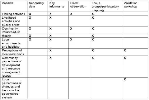
A triangulated approach using key informant interviews, direct observation, focus group discussions and participatory mapping was used to gather data at the community scale. Additional information was collected at the district and regional scales through district validation workshops and review of secondary information.
The Table below indicates the specific variables and corresponding methods that were used to gather the information.
Table 1. Summary of Data Categories and Methods Used to Gather the Information.
3.0 Rapid Assessment of Coastal Communities in in the
Western Region: Summary of Findings for Shama District
Background
A rapid appraisal was conducted in seven coastal communities in the Shama District between March 30 – April 12, 2010. The purpose of this assessment was to generate primary information that will ultimately contribute to establishing the overall baseline coastal conditions in the Western region and socialize the Integrated Coastal and Fisheries Governance (ICFG) initiative among the communities visited.
This appraisal collected mostly qualitative information and some quantitative data on issues relative to fisheries, community infrastructure, governance and institutions, local habitats and perceptions of resource management. The research team comprised five members, spending on average, two days in each community. Data was collected through focus group discussions, participatory mapping, direct observations and interviewing key informants. Information was also collected from secondary sources including development plans of the District Assembly.
The following report provides a brief overview of the Shama District as well as a synthesis of key fisheries, coastal and other coastal community development issues that were revealed during the field assessment and validation workshop organised at the district level. The Annex provides profile information and specific issues for each of the coastal villages within Shama District.
Profile of Shama District: Brief History of Shama
Shama district was established through a Legislative instrument (LI. 1882) in 2007. Prior to this, it was a sub-metro under the administrative authority of the erstwhile Shama Ahanta East Metropolitan Assembly (SAEMA).
Shama is one of the earliest villages along the coast of Western region with history dating back to the ninth century. Before arriving in Shama, early Fante migrants from Techiman settled in Eguafo. From this location, they further moved towards the sea at Abotre and Amanfokesedo – communities close to present time Daboase junction. After settling in Yabiw for some time, the predecessors migrated to the present location of Fort St. Sebastian where the first settlement of present time Shama emerged.
Physical Characteristics
and 200 metres above sea level. There are also few areas, mainly the valleys of the main river that do not exceed 150 metres above sea level (Shama District Assembly, undated). The shoreline features are characterised by open sandy beaches with near shore rocky bottoms and headlands in some areas. The coastline has eroded by an average of 100metres in the last 50 years. Typical shoreline erosion control structures are gabions and boulders. The surf energy is medium to high.
Local and traditional governance
Both local and traditional governance systems prevail in Shama District. While the local government derives from the national decentralized governance system, traditional governance is sanctioned by the Chieftaincy institution. Membership of the Shama District Assembly comprises District Chief Executive, a Member of Parliament who is an ex-officio member of the Assembly, 12 elected members and 6 government appointees. While the District Chief Executive is the political and administrative head, the presiding member – elected from the Assembly’s membership – presides over the legislative and deliberative functions of the Assembly. The district is sub-divided into 6 area councils – Shama Junction, Assorku Essaman, Inchaban, Shama, Supomu Dunkwa and Aboadze/Abuesi- and 64 unit committees. There are several departments and public agencies operating within the district. These include Departments of Agriculture, Non-formal education, Feeder roads, Community development, Police service, Judicial service, National disaster management organization etc.
Relative to traditional governance, the Shama traditional area is headed by a paramount Chief with jurisdiction over three main Chieftain Divisions and several divisional chiefs. The 3 Chieftain Divisions are Inchaban, Yabiw and Dunkwa. All traditional stool lands are vested in the paramount Chief of the traditional area (Shama District Assembly, undated).
Demographic Characteristics
Economic Activities, Livelihoods and Quality of Life
The economy of the district revolves around fishing, farming and petty trading. Shama has a long history of fishing pre-dating the colonial era. This period was characterised by the use of paddle canoes until the advent of outboard motors in the 1960s paved way for operating adi and drift gill nets. According to key informants in the district, fishers adopted watsa by the 1970s due to the labour intensiveness of removing fish from drift gill nets. It is also worthy to note that majority of fishers in Shama were erstwhile employees of the public sector – Ghana Railway Corporation- particularly from the 1960s to 1980s. The retrenchment of railway workers, which began in the 1980s was a significant factor that drove people into the artisanal fishing industry around this time. The last canoe frame survey in 2004 estimated a total of 11,109 fishermen in SAEMA (Amador et al. 2006) which comprised fishers in present time Shama district and Sekondi-Takoradi Metropolitan Assembly. The annual fish catch in the district is estimated at 30, 000 metric tonnes (Shama district assembly, undated)
Like fishing, farming in Shama district is a major occupation for the population. Both cash and food crops are cultivated and these include plantain, cocoyam, maize, rice, oil palm, cassava and vegetables. Tiger nuts and groundnuts are also cultivated on commercial scale. Prior to the 1980s, coconut plantations was a major source of livelihood for the people until the incidence of Cape Saint Paul wilt disease resulted in destruction of large hectares of coconut farms.
According to statistics from the district assembly, 78% of the population are engaged in farming and fishing. There is a direct correlation between fishing and trading in this district. The most recent bumper fish catch in the district was recorded in 1989 and 2001. Emerging trends indicate declining fish catches which is contributing to loss of livelihoods and reduced quality of life.
Environment
The district is drained by the historical Pra river which flows southwards and meets the sea at Shama. The Pra river delta comprises vast areas of marshlands while its estuary is associated with mangrove forests, dunes with tropical foliage, various species of birds which perhaps are migratory and diverse fauna. Some coastal wetlands and mangrove forests in the district have been degraded through filing and harvesting for fuel wood. However, as compared to STMA, wetland areas and overall natural ecosystems in Shama district is less stressed.
Land Use
The major land use patterns in Shama include agricultural, industrial and settlement. Agricultural lands are mostly located within the inland areas. Also, coastal communities located towards the eastern borders of the district have extensive agricultural lands. Large tracts of lands have been earmarked for Export Processing Zones (EPZ). The EPZs are part of a wider national programme aimed at attracting investors for development of commercial and service activities in selected areas. Land use changes from farmlands to settlements in Shama district is not as rapid as observed in STMA. However, the rate of shorefront construction especially for hotels and beach resorts is increasing in recent times.
Key Coastal and Fisheries Issues in Shama District
This field assessment revealed that what is unique and different about Shama district compared to other districts in the Western region is that it is a rural district with disproportionately high dependence on farming and artisanal fishing as sources of livelihoods. Even though the fishing communities are characterised by high population density, the overall population density of the district is relatively low. The district is experiencing significant growth in the tourism industry which is manifested exclusively in beach front hotel and resort development. Wetland areas and the overall natural ecosystem in the district are relatively less stressed. As compared to other districts, the role of traditional authorities in fisheries management is prominent. For instance, most Chief fishermen in Shama play key leadership roles in resolving conflicts that emerge from fishing expeditions while the roles of Chief fishmongers as negotiators of fish prices are respected and recognized. The rate of shoreline erosion in Shama is also quite high and needs immediate attention. The following section provides more detail about key fisheries, coastal management as well as other coastal community development issues within Shama district. The following issues were gleaned from field appraisal as well as district workshop.
Fisheries Issues
Declining fish catches is reducing quality of life in coastal communities. This was an issue expressed by all stakeholders during the assessment. The artisanal fishing industry in the district has witnessed declining fish catches in nearly the last decade. Fishing is the driver of the local economy in Shama – this is apparent in the high correlation between fishing and commercial activities in the district. Consequently, declining fish catches has not only reduced the quality of life in artisanal fishing households but also other households that survive on fish trade and small scale commercial activities. Furthermore, declining fish catches is increasingly changing the mode of operation of artisanal fishers in the district. Currently, most fishers from this district prefer to land their catches at the fishing harbour in Sekondi where they are assured of spot payment as opposed to credit purchase in the Shama district. These trends have contributed to displacement of livelihoods of particularly small scale fish traders.
by traditional laws. Furthermore, the predominant fishing methods in these communities make it impossible to undertake light fishing. Prohibition of light fishing in this part of Shama has contributed to rising conflicts at sea between artisanal fishers. This is because the fishery is open access and the fact that light fishing is prohibited by some communities does not exclude others from engaging in the practice in common fishing grounds.
Poor processing, storage and handling of fish leading to low value addition, loss of revenue and low profit margins. Poor post-harvest handling and processing techniques is a major constraint in all the fishing communities in this district. This problem manifests in the lack of cold storage facilities as well as ineffective post-harvest smoking and drying equipment. Consequently, fish is processed and handled under unhygienic conditions, particularly at the landing sites and processing sheds. As part of the government’s Cold Store project, the district will be provided with cold storage facilities in the coming years. It is also expected that this project will create employment and enhance incomes in the fishing communities.
Difficulty in accessing loans. Lower Pra Rural bank is a major creditor for fishmongers and fishermen, as well as small scale traders in the district. During the assessment, fishmongers and fishermen expressed the difficulty they encounter in the process of accessing loans to operate their businesses. Often, fishers referred to the issue of providing guarantors as the major constraint. On the other hand, personnel of the bank indicated high default rates among borrowers as a key factor hindering effective disbursement of loans to fisher folk. It was found out that loan capital get locked up in non-fishing related businesses operated by the fisher folks, particularly during low fishing seasons. Often, this resulted in lack of operating capital during the major fishing season, hence low loan repayment rate. Increasingly, other financial institutions like the SHACO credit union have emerged to enhance the overall access to loans and support small scale business operations in the district.
Coastal Management Issues
Coastal erosion is destroying habitats and property. Coastal erosion is destroying artisanal fishing settlements, fish landing sites and beaches. While the rate of erosion slightly varies from one coastal community to the other, overall, the shoreline has eroded by approximately 100 metres in the last 5 decades. Some efforts and attempts are being made to control shoreline erosion in some areas using gabions and boulders. In other areas, refuse are dumped at the shoreline to delay the rate of erosion. The current trends indicate that these measures have not been adequate in addressing the issue of shoreline erosion.
Sand winning is threatening coastal habitats. Although sand winning is illegal under the bye-laws of the district assembly, it is being practiced intensely along the beach front of some coastal communities. This activity is contributing to loss of sandy beaches as well as exacerbating coastal erosion. Other key assets and energy infrastructure are also threatened by this activity.
without replanting or undertaking any systematic regeneration activities. As population along the coastal strip and in the entire district increases, the remaining wetland and mangrove ecosystems will likely suffer degradation if no actions are taken to address this issue.
Other Development Issues of Concern in Coastal Communities
Poor sanitary facilities and waste management. Solid and liquid waste management is poor in the district. Particularly, solid wastes are dumped at the beachfront and into lagoons. Generally, solid waste disposal facilities are inadequate in the coastal communities and inland areas. In addition to the waste dumped at the shoreline, solid wastes from inland settlements are washed onto near shore marine areas through run-off. Although ZOIL has deployed personnel to clean beaches, there are significant challenges as regards ensuring adequate cleanliness of beachfronts.
Poor performance at the basic education level. Since the last decade, the district has recorded generally low performance at the basic education level. The district was ranked 16 out of the total 17 districts in the Western region in terms of performance at the basic level. In addition, school enrolment at this level is very low. During the appraisal, most teachers linked low enrolment and poor performance of children in particularly fishing communities to the lack of incentives including provision of free school uniforms, poor parental care and control as well as inadequate teachers. Lack of parental interest in education was also mentioned as contributing to this problem. Meanwhile, the district assembly and some private companies have instituted scholarship schemes to incentivise high performance of students in the district.
Prevalence of teenage pregnancy and high fertility. Teenage pregnancy and fertility are quite high in particularly the fishing communities in the Shama district. The rate of school drop-out among teenage mothers is also very high. High fertility is contributing to rising population in the fishing settlements with associated overcrowding and poor living conditions. The district has health facilities that provide various services including family planning. However, these facilities are not easily accessible by people living in distant communities. Also awareness raising on family planning is perhaps inadequate in the district.
References
Amador, K. Bannerman, P. Quartey, R and Ashong R. 2006. Ghana canoe frame survey. Information report number 34. Marine Fisheries Research Division, Ministry of Fisheries.
Ghana 43pages.
Shama District Assembly, undated. Shama District: a brief profile.
Appendix 1: List of Key Contacts
Community Contact Persons Position Telephone Number
Abuesi Nana Kondua Chief fisherman 0243681060
Maam Abronye Konkohene Sarah Donkor Fishmonger Abena Foriwaa Fishmonger John Ewusi Arhin Assemblyman
Shama Bentsir, Apo Frank Kwesi Yeboah Deputy District Coordinating
and Amena –ano Director
Nana Effirim Chief fisherman (Bentsir) 0242522193 Susanna Bisiw Secretary to Konkohene (Bentsir)
John Efedu GPRTU Shama
Nana Araba Nsiah Konkohene (Apo)
Nana Ackon Chief fisherman (Apo)
Kofi Assifuah Fisheries data recorder Kweku Odum Secretary to Chief fisherman
(Amena-ano)
Catherine Asuo Detective lance corporal (Shama police)
Aboadze Helena Offei- Bua Headmistress Attuah
Frederick Mensah Assemblyman 0275504457
Mariama Adam Trader
Nana Adam Eduafo Chief fisherman 0243932886 Anlo Beach Torgbe Tekple Garikor Chief
I
Afamenyo Agbeu Fishmonger
Awukuvi Kpordwudi Secretary to Chief fisherman Atwereboanda Stephen Mensah Secretary at Chief’s palace
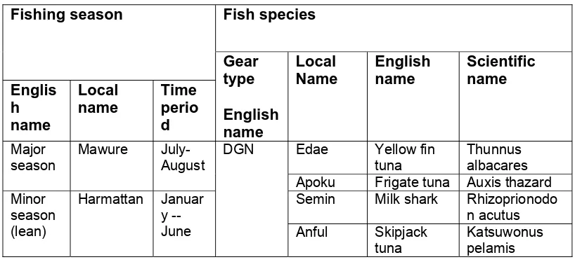
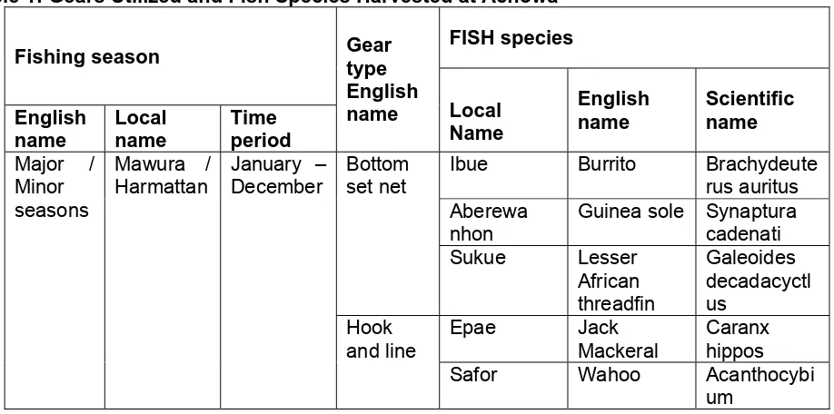
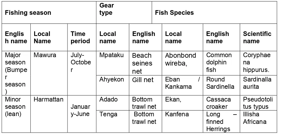
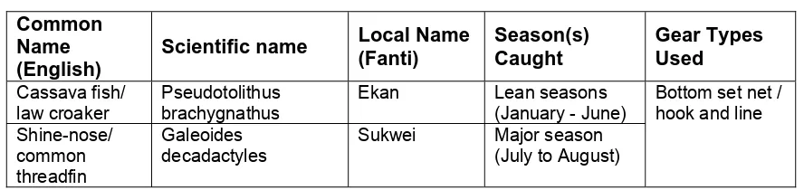
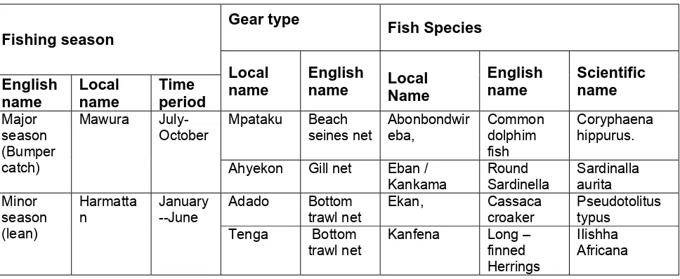
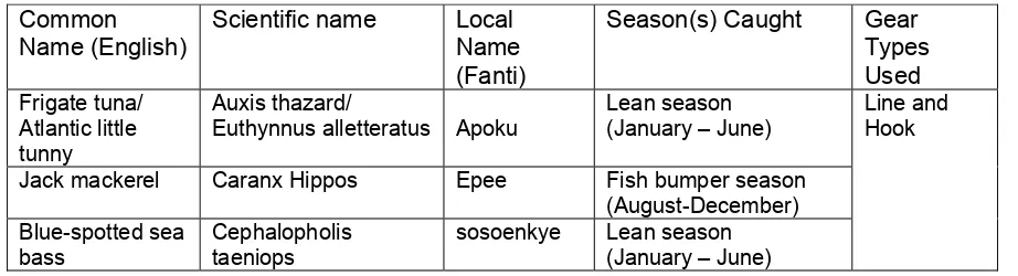
Appendix 2: Description of Fishing Gears
Gear Name (English)
Local Gear Name (A, T, F)
General Description Species Caught
Drift Gill Net Ashekon, Ali, This type of net is normally 100-450m in length Tuna, marlin, sharks (surface) nifa nifa and 15-20m in depth. Its mesh size varies from
100-250mm. It is used all year round. It also uses 40HP outboard motors. This gear is operated by 8-12 crew members. It mainly targets large pelagic species. It is mde with yarn of R 390 to 620 or 950 Tex, as per netting availability. It is usually set at sunset and pulled out the next morning. Hauling is done manually.
and mostly
sardinellas, herrings, manta ray,
Bottom set gill Tenga The length of this net is 10 yards and can be All species of fish like net joined together with a depth of 2-3 yards. The
material used is monofilament. It has mesh sizes of 1½, 1¼, 15/8 and 17/8 inches. This gear is operated by 2-3 crew members. These nets are used to catch both demersal and pelagic species. It is made from polyethylene material which could be about 200 yard long and 1.5 yards wide. They can also be joined to get any required length or dept. It is operated from small and medium-sized vessels. They set off at about 3.00 a.m. and land at 2.00 p.m. the same day. This gear is set for about 3-4 hours before it is hauled. They are most often used in the minor season.
herrings, sardillinas purse seine mesh size. The length of the nets used is 450-
500 yards and has a depth of 50-60 yards. Some fishermen put in nets with smaller mesh sizes into the Watse net. This is done to target smaller species of fish particularly anchovies. It mostly employs 20-30 crew members and uses 40HP outboard motors. They are use mostly in the major season which comes between July and September. 20mm mesh size. It is made with thread. They are used by big canoes, semi-industrial vessels as well as semi-industrial vessels. These canoes usually have a small canoe which carries generators for light fishing. The big canoes have 12-25 crew members. They set off at 5pm and land at 8am the next day. They are usually used in the major season. They usually target pelagic species but are able to catch demersal species too. It costs about Gh.¢50,000.00
Gear Name (English)
Local Gear Name (A, T, F)
General Description Species Caught
Hook and line Asosow It targets big demersal fishes as well as large pelagic. They employ 5-10 crewmen. They use hooks with numbers ranging from 1- 16 inscribe on them. They signified the different sizes of the hooks. The lines used are also of different sizes with numbers 8, 10, 12, 14, 16 inscribed on them. They are made of nylon. They are also used to catch fish from rivers and lagoon.
Red fish, tuna, sea bream snapper, grouper, yellow fin
Beach seine Tweewui They employ 5-7 crew members and 2 help hands. This gear is commonly used in the Anlo Beach. The average distance from the shoreline to where the net is set is about 1 to 2 km. The size of beach-seine nets varies from 480 m long (excluding ropes) by 8 m deep to 1 640 m long by 22m deep. The net is mainly operated in the areas of concentration of the young, whether pelagic or demersal species. It requires 30 to 50 men to haul a small net and 50 to 100 men for a big net. A canoe is required to go offshore to cast the net. The net may be left in the sea for u to two days before it is hauled.
Appendix 3: Description of Fishing Vessels in Shama District
Boat Type Local Name(s)
General Description Gears Used
Small Canoe - This type of canoe vessel is Drift gill net (surface). (motorized) approximately 30m long and 2m wide
made from a single dug out log. The preferred wood is Wawa. Above the dugout, the hull is planked. Outboard motors of 40 HP mounted on the read right (starboard) side of the vessel. It costs about Gh¢5,500. These vessels cost approximately Gh¢12,000
Bottom gill net, hook and line, long line.
Small /medium Canoes - These are used by fishermen who do Drift gill net (surface). (non-motorized) beach seining. They use paddles. It is
also used by the service boys to bring the fish to the shore. It uses only 2-5 crew members. They are dug out logs of about 6-12 yards in length and about 2 yards in width. Paddles are used on these canoes.
Bottom gill net, hook and line, long line
Medium - These are mostly used by artisanal Hook and line, anchors canoes(motorized) fishermen who use the hook and line.
Wawa is usually used in constructing. Between 5- 10 crew men work on such canoes. They usually spend between 6-8 days on an expedition. They leave anytime they wish and fish throughout the week. They also use ice blocks to preserve their catch because of the number of days spent on an expedition. They use sardines as bait to catch the specific species they go in for. They use anchors with 10mm anchor ropes to stabilize the canoe whilst they fish. The canoe uses outboard motors of 40 HP which cost about 5,100 Ghana Cedis at subsidized rate. They also use premix fuel but have to rely on Super
whenever there is a shortage of premix.
Large Canoe Waste This canoe is named according to the Ring Net/small purse (motorized) type of net it uses. They use premix
fuel. They range between 23-26 yards in length and about 1 1/4 to 1 1
/2 yards in width. The crew size of this type of canoe ranges from 20 to 30 men. They use outboard motors of 40HP.
Appendix 4: District Validation Workshop Outputs
Theme: Natural Environment
Theme: Livelihoods
Theme: Land Use
Variable Timeline (in the past)
Causes of change Consequence Governance response
Processing EPZ until 5 yrs affected the export livelihoods. assistance from Zone(EPZ) ago in Abuesi processing zones
(EPZ) Settlement Over 40 years
ago (decrease) Shore front 3 yrs ago Urbanization of Job creation. Activities of Construction (increased) Shama District
Theme: Demography
Variable Timeline (in the
past)
Causes of change Consequence Governance response
Trend in
Appendix 5: Stories from the field
Box 1
:
The
tale
of
Chief
fisherman
‐
Shama
Bentsir
About 12years ago, we signed a pact withthe lesser gods regarding lightfishing. This actionwas initiatedfromtheWesternregionandIledthedelegationtosweartheoathsinceIwastheChairman oftheWesternregioncanoefishermencouncilatthetime. Onthatoccasion,wetookwithus,bottles of local drinks and visited every fishing village in the Western Region, and together with the Chief fishermanofthatvillagesworebythegodsoftheseanottopracticelightfishingorusedynamitefor fishing. This was also replicated in other parts of the country. However, as the activities of pair trawlersinourwatersincreased,theinshorefishersrecognizedthattheywerebeingoutcompetedand resortedtotheuseoflight.Themovebyinshorefishersnecessitatedoverturningofouroathtopave wayforartisanalfishersto alsopracticelightfishing.TheChieffishermanofAbuesiplayeda leading roleinoverturningtheoathsincehewasthechairmanoftheWesternRegionCanoefishermencouncil atthetime.
Box
2:
The
tale
of
a
fishmonger
‐
Aboadze
Whenfishermenwithlightgetfishthefishmongersclose tothemgetsomefishtosellandalso feed theirfamilies.Increasingly,fishmongersoperatingwithcanoesnotpracticinglightfishingarefindingit more and moredifficult to survive. On most occasions these canoes donot land any catch,hence thoseofusdepending onthemdonotgetfishtofeed ourfamiliesorselltoeducateourchildrenin school.Andthispresentsasituationwheresomearebenefittingwhileothersarefindingitdifficultto survive.Ithinkthatbanninglightfishingwillensuresomelevelofequityintheaccesstofish.
Box
3:
The
tale
of
a
community
leader
#‐
Aboadze
An
nnex A
A:Coa
astal V
Villagee Summ
maries for
S
Shama
a Distrrict
Anlo Beaach Pra river eestuary
ABIESI
Physical Characteristics
Abuesi is a large urban1 fishing community located in Shama district. The community and surrounding area is characterised by flat and hilly landscapes. The coastline comprises slightly curved sandy beaches extending from the Western to the Southern edges of the population concentration. There are two fish landing sites- Abuesi and Kesewokan- in the area. Rocky outcrops are present in the near shore areas. Information from local fishermen suggests that the near shore areas also contain ship and aircraft rubbles.
Demographics and Settlement Patterns
Statistics from the Planning Unit of the Shama District Assembly indicate a population of 8,873 as of the last census in the year 2000. As of the year 2007, approximately 9,059 people lived in the community. There are close to 700 houses in the community. The houses in the main settlement areas are tightly clustered and mud-built. Most of these houses are plastered with cement and roofed with corrugated asbestos. At the southernmost shoreline is a cluster of several housing units. These are temporal structures with walls made of bamboo or raffia palm fronds and roofed with thatch. Similar housing structures are located at the Western edge of the community. However, in this area they are situated few yards away from the shoreline. While providing shelter for fishmongers, these houses double as fish smoking sites. There are neither toilet facilities nor bath houses in most of the households in this community. A tarred road links to the main market and lorry station located close to the area of population concentration and further extends to the Abuesi landing beach. There are 12 churches and 3 mosques at Abuesi. There is a school complex and community library shared with the adjacent community. The nearest hospital is the Volta River Authority (VRA) hospital, which is situated at approximately 600metres from the community. Abuesi Beach Resort is located on the hills at the South-eastern edge of the coastline.
Majority of the people at Abuesi are Fantes from Ottom, Ankra and Moree in the central region. Few residents are Ewes and Ahantas. The first Fante settlers migrated to Abuesi in the eighteenth century. Most local residents indicated that fishing migration to the community occurred in the 1970s according to the fishing seasons. At the present time, fishing migration follows monthly patterns. It also emerged that low fish catches being experienced at the present time has spurred migration of most fishermen and their families to countries including Liberia, Benin, Gambia and Nigeria to engage in fishing.
Economy
The businesses in the community are micro and small scale. And these trade in various goods and services. The Volta River Authority (VRA) and West Africa Gas Pipeline Company (WAGPCo) are the major industries located within the vicinity of Abuesi but employing an insignificant number of residents, mostly as security and casual labourers. There are no banks or credit unions in the community. The major livelihood option is fishing.
Farming
There are no farmlands in the community or within the immediate surroundings.
Tourism
Abuesi Beach Resort is situated on the hills overlooking the ocean at the south-eastern edge of the community. The resort offers 4 double Villas, each with eight double rooms that rent for a minimum of 55 Ghana Cedis per night. Within the resort are monkey attraction sites for visitors. According to a key informant, the resort is mostly patronised by locals rather than expatriates. Located further east of the resort are the Shama Beach Resort and Pra River Gulf Links owned and operated by Volta River Authority.
Fisheries
The artisanal fishing industry dominates the coastal strip of this community. As of 2004, close to 110 canoes comprising 25 small and 85 large sizes operated at Abuesi. At the time of the appraisal, 92 canoes lined the coastline. These canoes operate different fishing nets according to their sizes. Canoes with length ranging between 23-26 yards and up to 1.5 yards width operate the ring net and deploy between 20-30 crewmen. These canoes utilize 40HP outboards and catch mainly sardinellas. The drift gill net is operated by canoes having 16-18 yards length and 1 yard width. These also utilize 40HP outboards and mostly harvest sardinellas. The bottom set net is operated by canoes of 10 yard length and less than 1 yard width. In addition to the 25HP or 9.9HP outboards utilized by these canoes, they are propelled by paddles. They harvest mainly demersal species. Lagoon fishing is also practiced to a lesser extent in the Attomu lagoon with crab traps and cast nets as the main gears. Species harvested from the lagoon are mpatowa( tilapia), mambai (flat-head grey mullet), nkafuna (long finned herrings) and crabs.
Processing is done in the fishing settlement areas by smoking sardinelles, frying nkafuna (long finned herrings) and drying anchovy. Some fish are also processed by salting. The major marketing centers for fish from this community are Kumasi, Accra, Agona Nkwanta, Techiman and Kasoa. Twice weekly, fishmongers also travel to neighbouring Togo to sell fish. The Konkohene maintains her role as the negotiator of prices of fish landed in this community. The proceeds from fish sold are divided into two- the canoe owner takes one half while the other half is shared among the crewmen. Tuesdays are fishing holidays and also during the major fishing seasons – July to September- there is a ban on lagoon fishing which gets lifted after the season.
Environment
The shoreline is polluted with plastics and debris as well as human excreta. It was indicated that waste disposal at the shoreline is a mechanism for curbing increasing rate of coastal erosion. Untreated liquid waste sewage from inland areas enters the sea. It was observed that approximately 200m x 100m size of wetland located on the south-western side of the community has been reclaimed. What remains is a streamlet of less than an acre in size. It was indicated that this area was part of a lagoon some years ago. The streamlet is piled with solid waste.
spawning ground. Information from residents also pointed to the fact that whales and dolphins are often observed in the marine areas, particularly during the month of August. The elevations close to the shoreline is covered by lush tropical foliage. It was expressed that marine turtles nest and feed at the coastline. However, it emerged that turtles are harvested and consumed in this community.
Local Institutions and Governance
Until the half last decade, the Chief fisherman of Abuesi doubled as the substantive Chief of the community. Currently, there is a non-resident Chief who visits the community periodically. Both the Chief fisherman and Chief of Abuesi owe allegiance to the Omanhene of Shama. Together with his counsel, the Chief fisherman has jurisdiction over disputes that emerge from fishing expeditions and also administer traditional laws on fishing in the community. However, issues that border on criminality – like cases of deliberate drowning of fishermen- are referred to the police. There is also a Konkohene with prominent role in negotiating for prices of fish. There is a CBFMC which is not functioning effectively. A new market is being built for the community by the Shama District Assembly. Yet, majority of residents expressed that the Assembly is not contributing adequately to addressing their development needs. The West African Gas Pipeline Company (WAGPCo) supported the construction of a storm drain from the area of population concentration to the sea.
There is a student association which doubles as a youth group. Membership comprises secondary and tertiary students
Key Coastal and Fisheries Issues
Declining fish catches: Fishers in this community agreed to the assertion that fish catches
has dwindled over the years. They attributed this problem to light fishing, pair trawling, use of carbide and dynamite as well as increasing fishing effort. They further exemplified catch decline by indicating that while 200 pans of fish were harvested per expedition in the past decade, less than 50 pans are harvested in the present time. It was also expressed that species like Apaa and Asafor are barely harvested in recent times.
Coastal erosion: It was suggested that the beachfront has eroded up to 100 metres in 5
years. Some houses at the shorefront were indicated to have been washed away. This problem was attributed to the effects of construction of the Takoardi Harbour.
Inappropriate fishing methods: Fishermen in this town practice light fishing and use
dynamite and carbide in their operations.
Declining quality of life: Fishermen expressed their difficulty in meeting the subsistence
needs of their families in recent times. They indicated that fish catch decline has reduced their incomes significantly, hence their inability to cater for basic needs of their families. It was expressed that fishermen resort to stealing to make ends meet, particularly during the lean fishing seasons. On the other hand, fishmongers mentioned that in times of fish shortage, they resort to selling of their clothes as coping strategies. They however indicated that transactional sex for fish is not an option in times of fish shortage.
Inadequate human waste disposal: There are no household latrines and bath houses.
Most residents use the shoreline as sites for defaecation.
Changes in fishing seasons: While the major, minor and lean fishing seasons existed in
Lack of loan capital: Women fishmongers complained about the lack of loan capital available to operate their business or expand operations. Few also find it difficult to access bank loans as they have no collateral.
Inadequate cold storage facilities: There is no public cold-storage facility in the
community. The only private cold store cannot handle the large volumes of fish landed during the high fishing season. Most fishmongers travel to Takoradi to store fish in cold storage facilities.
Poor drainage: An uncompleted storm drain from the settlement areas is piled with solid
waste, resulting in poor water drainage.
Weak institutions: The role of the Chief fisherman was reported to have been undermined over the years by non-recognition of his authority by the conventional courts and law enforcement agencies. According to some informants, the CBFMC is a good concept but has failed to function effectively due to reasons such as difficulty in gazetting their byelaws and failure to attend meetings.
Conflicts over the use of marine space: there have been instances where nets of canoe fishers have been destroyed by the activities of big vessels and pair trawlers. Canoe fishers are usually compensated with fish under such circumstances. Also Chief fisherman sees to amicable resolution of such conflicts.
Poor management of premix fuel: Fishermen expressed that premix shortage is regularly experienced in the community, particularly during the high fishing seasons. During such periods, they are left with the only option of purchasing relatively expensive fuel for fishing expeditions.
Reclamation of wetlands: Wetlands in this community are stressed by housing development and solid waste disposal.
Recommendations
Key recommendations made by community members to address the above issues include; ク diversification of livelihoods as coping strategy, particularly during the lean fishing
seasons.
ク provision of loan capital to fishmongers.
ク enacting and implementing laws that ban use of light, dynamite, carbide and DDT for fishing Proactiveness of the Navy in policing Ghana’s territorial waters.
ク reduction or waiving taxes on fishing inputs.
ク provision of social amenities and scholarships to brilliant students.
Additional opportunities for ICFG include;
SHAMA BENTSIR, SHAMA APO, AMENA-ANO
Physical Characteristics
Shama is a large commercial town located in the Shama district. The town is characterised by a mix of hilly and flat landscapes. Within an estimated 30 yards from the coastline, the landscape is relatively flat. It rises inland and flattens out further north. The highest elevations – of approximately 100 metres - back Amena-ano, which is a relatively small community located at the South-western border of Shama. The town is bordered on the East by the vast River Pra, which flows southwards and joins the sea at the South-eastern coastline – shoreline of Shama Apo. The Pra estuary is separated from the sea at the coastline of Shama Apo by approximately 700 metres stretch of sand dune. Few metres of stone sea walls and gabions also characterize the coastline of Shama Apo. The Pra River drains the surrounding communities located towards the North-eastern side of Shama. The shoreline is characterised by curved sandy beaches interspersed with near shore rocky bottoms. The ocean areas are open with spilling surf. There is extensive algal growth in the marine areas on the South-western part of Shama.
Demographics and Settlement Patterns
There are three main settlement areas that characterize the most part of coastal Shama. Located on the farthest South-west is Amena-ano, which is characterised by a cluster of about 50 houses constructed mainly with mud and roofed with corrugated asbestos and thatch. Few houses in this community are made of cement walls. Houses in this settlement area are interspersed with fish processing facilities and are not connected to the national electricity grid. At the shoreline of this hamlet, just 5 yards away from the water mark at high tide, a hotel – Alabamba Beach Resort - is being constructed. According to statistics from the Shama District Assembly, the population of Amena-ano was 308 as of the year 2000. Some opinion leaders in the community indicated a population of nearly 1,000 persons at the present time.
According to statistics from the District Assembly, Shama (Bentsir, Apo and Etsifie2) was inhabited by 9,855 people as of the year 2000. This number increased to 10,062 by the end of 2007. Shama is a commercial center and the seat of the District Assembly. The businesses in the town are mostly small scale and are lined along the principal street that links the town and the other streets connecting the settlement areas. These streets are mostly tarred. There is however, an untarred road that links the landing beach at Shama Apo. A market is located close to the area of population concentration with the office of the Ghana Fire Service located nearby. At the time of the appraisal, a fire tender was on stand by close to the market. There are several public water standpipes located at various points in the town. While few households have toilet facilities at Bentsir, two public latrines; a 10 seater and 24- seater, situated at the shoreline are used by majority of the population. Such facilities are situated at similar location at Apo. There is a Junior High School (JHS), Senior Secondary School (SSS) as well as nursery in the town.
The Shama Health Centre is located few metres from the areas of population concentration. Health information collected during the appraisal is indicative of district wide trends rather than community specifics. It was expressed that 4 private clinics and 3 government health centres are located in the district. It was also indicated that the top 10 diseases recorded in the district for 2009 (in descending order of importance) were Malaria, Acute Respiratory Infection, Skin Diseases and Ulcer, Diarrhoeal Diseases, Intestinal worms, Rheumatism and Tout Pains, Hypertension, Anaemia, Vaginal Discharge, Home Accidents and Injuries and Other Diseases. Fertility increased from 2,115 pregnancies in 2008 to 2,491 pregnancies in 2009. Furthermore, 19 out of the 59 deliveries recorded only at the Shama Health Centre for March 2010 were teenagers between the ages of 15-19. The district recorded under five mortality ratio of 3 for the year 2009.
Fante is the dominant ethnic group in Shama. The Fantes mainly reside westwards of the Pra River. Two main groups of Fantes can be distinguished; the first are the indigenes of Shama who identify themselves as Fantes with Techiman as their ancestral origin while the second are migrant Fantes from Moree, Apam and Winneba in the Central Region who acquired permanent residency in Shama over 5 decades ago. While the indigenes reside at Shama Bentsir and Shama Apo, the migrants are confined to Amena-ano. There is a fair level of interaction between these two groups. Residing at Anlo Beach (refer below for complete profile of Anlo Beach), on the farthest South-east, are the Ewes who are the ethnic minority in terms of population size. The only means of transport from Shama to Anlo Beach is by canoe or boat. Perhaps, the inability of most Ewes to speak the Fante language is indicative of limited socio-cultural interaction between them and the Fantes. The main religious denominations in Shama are Methodist and Catholic. . There is a mosque, indicative of the presence of Muslims.
Fishing migration is a common practice in Shama. This dynamic occurs at different levels and due to varied reasons. There are trends towards migration to other coastal areas in Ghana or coastal countries in the sub-region in response to availability of fish or the need to raise money to payback accumulated debts. At times, whole families migrate or the fishmonger/maamenie migrate with the canoe to other countries. They spend between 2 months to 2 years or even longer periods depending on the destination and market. At their countries or places of destination, fishmongers work for enough money to remit home and also to payback debts. It is also noteworthy that price of fish is also a driver of migration, particularly in cases of in-migration to other coastal communities in Ghana.
Economy
Majority of residents at Bentsir, Apo and Amena-ano are employed in the fishing industry. Other livelihood options are petty trading and vending undertaken by the small and micro businesses lining the streets in the town. It is to be noted that most fishmongers trade in agricultural produce, particularly during the lean fishing seasons and periods of low fish catch. Agricultural products are purchased from farming communities in the District. It also emerged that fishmongers purchase frozen fish from cold stores, which they later smoke for sale. Some fishmongers expressed that, they adopt these strategies in order to earn incomes to facilitate loan repayment and also cope with hardships associated with low fish catch.
Few residents are engaged in formal employment at the offices of the District Assembly, mainly as labourers, secretaries and security guards. Fewer are also employed by Zoil Ghana Limited as beach cleaners within the framework of the Eco Brigade project. At the time of the appraisal, some youth workers of Zoil indicated their loss of interest in this job since there has been over 4 months delay in payment of salaries.
The Lower Pra Rural Bank is headquartered in Shama and situated some few metres away from Bentsir, Apo and Amena-ano. It was expressed that Lower Pra is the major saving destination for most fisher folk interested in bank transactions. However, SHACO credit union, which has been in operation for almost 3 years, is also a key player in the local financial market. These two financial institutions advance loans to clients – particularly fisher folk- according to different criteria. SHACO loans are only disbursed to groups. Each individual in the group receives twice the amount of money in their SHACO savings account. On the other hand, disbursement of group loans at Lower Pra is subject to operation of a group account at the bank. Furthermore, Lower Pra disburses loans to individuals on condition that they present guarantor. The guarantors in most cases are customers of the bank and mostly considered credit worthy. The relative difficulty in accessing loans at Lower Pra was expressed by most fisher folk.
Farming
Farming is not practised to any significant extent in the three communities. In Amena-ano, cassava, maize and some vegetables are cultivated on less than half acre plots for mainly household consumption.
Tourism
any source of water supply. In 1471, a cross was mounted at the shoreline of Shama to symbolize the arrival of first Europeans - Portuguese missionaries -in the town. Although this cross was rebuilt some 50 years ago, it is located at the original position at present time. The people of Shama celebrate the ‘Pra Nyinani Afahye’ which is the major festival organised in September of every year. It was indicated that the town witness massive influx of people from within and outside the country during the festival.
Fisheries
The artisanal fishing industry dominates the coastline of Shama. There is a landing beach in each of the three fishing villages. However, there are no modern landing facilities. During the last Canoe Frame Survey in 2004, the number of canoes recorded at Bentsir and Apo were 242 and 265 respectively. According to the Fisheries Data Recorder, the number of canoes operating in these areas has increased significantly over the last few years. This information was corroborated by many fishermen, with the mention of the fact that most canoes in Shama are now operating in countries like Liberia and Ivory Coast. Nonetheless, at the time of the appraisal, 125 and 211 canoes lined the coastline of Bentsir and Apo respectively. It was indicated that 9 canoes operate at Amena-ano at the present time. The large canoes operating in Bentsir and Apo are 18-19 yards long and 2 yards deep. And these utilize 40HP outboards, operate drift gill nets and deploy between 9-10 crewmen. Species harvested by the large canoes include tuna, marlin, skipjack, manta ray, all types of shark, sailfish, dolphins, turtles etc. The medium sized canoes are 12-14 yards long, 1.5-2 yards deep and utilize 40HP outboards. These canoes operate ‘’ali’’ nets and deploy 7 crewmen. Species harvested by medium sized canoes include eboe (burrito, big eye grunt), edoe (barracuda) poanoma (flying fish), herrings, nkafuna (long finned herring/ West African Illisha) etc. The small canoes are between 3-7 yards long and 1 yard wide and utilize 8, 9.5 or 15HP outboards. These canoes operate Tenga / Tengraaf (bottom set nets) as well as hook and line. Tenga / Tengraaf nets harvest eboe (burrito, big eye grunt), eckan (cassava fish), Long finned herring/west African Illisha, lobsters, crabs, eel, silver fish, daisy sting ray while hook and line harvest snapper, doctor fish, barracuda etc.
On the other hand, canoes at Amena-ano mostly operate the ring net and utilize 40HP outboards. These are relatively large canoes of 30 feet length and 7 feet depth and deploy 25 crewmen. The main species harvested are herrings, mackerel and tuna. Lagoon fishing is undertaken to a limited extent using set nets and crab traps. Species captured include tilapia, mudfish, perwinkle and crabs.
Both large and medium sized canoes share proceeds according to laid down ratios. Monies realized from fish sale are divided into two equal parts. One part pays for operational and maintenance costs (petrol, gear repairs, outboards etc) and the other part is shared equally among the crewmen and canoe owner. It is to be noted that this sharing system is rather simplistic. While fishers did not readily disclose information about the details of the sharing system, it was indicated for instance that, sharing is done on pro-rata basis according to age (elderly crewmen receive more than young), role (boat owner receive more than manager) etc. The large canoes operate up to 2 years before sharing proceeds while the small canoes share proceeds after every fishing season - major upwelling season occurs between June-September while the lean fishing season spans February–May. Tuesdays are fishing holidays in Shama.
ntatamire (atlantic bumper) are dried at Amena-ano. Major market centres for fish harvested in the three fishing villages are Accra, Agona Nkwanta, Kumasi, Sekondi, Mankessim, Tamale, Techiman, Prestea, Tarkwa, Beposo, Inchaban and Takoradi.
Environment
The shoreline is polluted with plastics and debris as well as human excreta. Untreated liquid waste sewage from inland areas enters the sea. Large quantities of untreated domestic wastes are discharged from the inland areas into the marine environment. Information from some residents at Shama Bentsir suggested that disposal of effluents from the public latrine located at the shoreline is through flushing into the marine environment. The coastline at Amena-ano was indicated by residents to be turtle feeding and nesting sites. Turtles are trapped by drift gill nets and usually consumed. Towards the West of Amena-ano is the Amena lagoon which is separated from the sea by a barrier of sand. About 10 acres of mangrove fringe this lagoon.
Local Institutions and Governance
There are two parallel government systems in operation at Shama: the district assembly structure with elected and central government appointed personnel and traditional administrative system deriving from chieftaincy institutions. While the DCE is the political head of the district, two elected assemblymen with clearly defined territorial jurisdictions operate in the fishing villages. These jurisdictions are divided between Shama Bentsir and Amena-ano on the one hand, and Shama Apo and Anlo Beach on the other. The Assemblymen facilitate development projects spearheaded by the District Assembly in the communities. The district assembly has four key priority areas: education, health, agriculture and job creation. The fishing communities are considered during programming in these areas. Specifically, the Assembly is open for collaboration on the use of child labour in fishing and also providing training for coastal youth. It was expressed that Shama is a beneficiary of the District Cold Store project and it is expected that this will create employment in the fishing villages. Gazzetting of the CBFMC byelaws is also being considered by the Assembly. However, it was indicated that, there is the need for further stakeholder consultations on the content of the CBFMC byelaws.
There is an Omanhene of Shama Traditional Area residing at Shama Bentsir. The sub-Chief of Amena-ano owes allegiance to the Omanhene. There is a Chief fisherman in each of the three fishing villages. Conflicts and disputes arising from fishing expeditions are usually addressed by the Chief fishermen. Fisher folk cited instances where the Chief fisherman of Benstir cooperated with the Shama police to address conflicts that resulted in near drowning of a fisherman in the territorial waters of Shama. In addition, fishers often referred to the lead role of Chief fishermen in resolving issues related to destruction of canoe fishing gears by pair trawling vessels. Sale and distribution of premix in Bentsir and Apo are also the respective responsibilities of the Chief Fishermen in the communities.
beach committee according to laid down ratios. In Bentsir, the community’s share of premix profits is being spent on construction of offices and conference hall for the fisher folk while in Apo, accounts on premix sale are yet to be rendered to the community. There is no landing beach committee at Amena-ano since this village lacks a premix outlet. There is a CBFMC at Bentsir which is relatively well organised, with executive members meeting on Mondays. The CBFMC functions as a platform for information dissemination to the fisher folk.
There is a fisheries data recorder stationed at Shama, but with a mandate for recording catch statistics at the landing beaches in Shama, Aboadze and Abuesi. There is a Konkohene in each fishing village with a prominent role in negotiating prices of fish. Maamefo (fish mammies) at Shama contribute to pre-financing fishing expeditions. However, such investments are very marginal as compared to what pertains in Sekondi-European Town. And unlike in Sekondi- Sekondi-European Town, where maamefo play lead roles as regards fish pricing in respect of expeditions they pre-financed, in Shama, the final prices of all fish landed are solely determined by the Konkohene without recourse to maamefo. It is also noteworthy that adequate knowledge and skills in fish marketing is a major criterion for being selected as maamenie3 of a particular canoe in Shama.
It was also expressed that traditional laws regulate the role of children in fishing. School children between 6-12 years are not allowed at the beach during school hours. Mothers of these children are forced to pay penalties on instances where these regulations are flouted. However, children 8 years and above but not enrolled in school are sent on fishing expeditions and taught fishing.
The Ghana Private Road and Transport Union (GPRTU) operates a trotro (van) service in Shama. The trotro transports people and goods from Shama to Takoradi and nearby communities. It emerged that trotro is the main means of transportation of fish from Shama to Agona Nkwanta, Beposo and Sekondi. However, if fish are to be transported to much longer distances – for instance to Kumasi and Techiman- officials of the GPRTU serve as intermediaries in order to facilitate access to transport by the fishmongers.
There are few active civil society organisations in Shama. Key actors are Integrated Action for Development Initiatives (IADI) and Support for Community Mobilization Project (SCMP). Activities of these organisations include supporting decentralization, biodiversity conservation, women empowerment and community mobilization.
Key Coastal and Fisheries Issues
Declining fish catches: this problem was expressed by fishermen, fishmongers, fisheries
data recorder and all other stakeholders interviewed. This was mainly attributed to the use of light, dynamite as well as small mesh sizes for fishing. Although fishers in Shama indicated that light fishing is prohibited by traditional laws, they further expressed the fact that this method is practiced on the territorial waters of Shama by canoes from other fishing communities. It also emerged that light fishing cannot be practiced with the type of fishing gear predominantly in use at Shama. Perhaps this explains non-use of light for fishing in Shama Bentsir and Apo. Fishers at Amena-ano however, practice light fishing.
Difficulty in accessing loans: there was unanimous agreement that loans are difficult to
access from Lower Pra Rural Bank. Often, fishers referred to the issue of providing guarantors as the major constraint. It also emerged that high default rates characterises the
3Singularof