IOP Conference Series: Earth and Environmental Science
PAPER • OPEN ACCESS
International Conference on Earth Science, Mineral, and Energy 2018
To cite this article: 2018 IOP Conf. Ser.: Earth Environ. Sci.212 011001
View the article online for updates and enhancements.
Content from this work may be used under the terms of theCreative Commons Attribution 3.0 licence. Any further distribution of this work must maintain attribution to the author(s) and the title of the work, journal citation and DOI.
Published under licence by IOP Publishing Ltd
IOP Conf. Series: Earth and Environmental Science212 (2018) 011001 doi:10.1088/1755-1315/212/1/011001
PREFACE
Dear authors from ICMT2018;
On behalf of all conference committees, I sincerely appreciate your participation and support for ICMT2018.
The 2nd International Conference on Manufacturing Technologies was successfully held in Florida Polytechnic University, FL, USA during January 15-17, 2018. Our conference venue, Florida Polytechnic University, is Florida’s accredited public university with an exclusive focus on the core STEM disciplines of engineering, technology and applied science. ICMT2018 reflected the technology needs manufacturing technologies science. This proceeding contains the reviewed papers presented at the ICDME 2018 and covers trending and important issues related to manufacturing technologies and other main ICMT Topics. ICMT2018 conference papers consisted of different types of presentations including keynote, oral, and poster presentations offered by researchers, engineers, and graduate students. ICMT2018 received 97 papers from different counties, only 41 papers were accepted to present at the conference. As a platform for technical exchange, each author has 15 minutes to introduce his or her research. In addition to the presentation, each author is encouraged to connect and exchange ideas with other scholars. The conference is also an opportunity to explore research on manufacturing technologies presented by different participants. With the fast globalization of technology and manufacturing, technical issues will be discussed and disseminated in a global forum in which researchers and engineers with international experiences are invited to share their expertise and views.
The support from all authors and committee members will surely lead to the success of ICMT2018. We hope that the participants of ICMT2018 will have fruitful discussions among each other and collaborate on future projects on manufacturing technologies.
Professor. A. R.Al-Ali American University of Sharjah, UAE
IOP Conference Series: Earth and Environmental Science
PAPER • OPEN ACCESS
Committee List
To cite this article: 2018 IOP Conf. Ser.: Earth Environ. Sci.212 011002
View the article online for updates and enhancements.
Content from this work may be used under the terms of theCreative Commons Attribution 3.0 licence. Any further distribution of this work must maintain attribution to the author(s) and the title of the work, journal citation and DOI.
Published under licence by IOP Publishing Ltd
IOP Conf. Series: Earth and Environmental Science212 (2018) 011002 doi:10.1088/1755-1315/212/1/011002
Conference Chairs
Prof. Ramesh K. Agarwal, Washington University in St. Louis, USA Prof. Dr. Ridha Ben Mrad, University of Toronto, Canada
Prof. A. R.Al-Ali, American University of Sharjah, UAE
Conference Co-Chairs
Prof. Houssain Kettani, Florida Polytechnic University, USA
Technical Program Committee Chairs
Prof. Yong Suk Yang, Pusan National University, Korea
Prof. Chih-Shing (Stan) Wei, The Cooper Union for the Advancement of Science and Art, USA
International Technical Committees
Prof. Guo Xinli, School of Materials Science and Engineering, Southeast University, Nanjing, China
Prof. TANG Guoyi, Tsinghua University, China
Prof. Md Mustafizur Rahman, Universiti Malaysia Pahang, Malaysia Prof. Faiz Mohammad, Aligarh Muslim University, India
Prof. K, Lawrence DeVries, The University of Utah, USA Assoc. Prof. Gang Ke, Guangzhou University, China Assoc. Prof. Recai KUS, Selcuk University, Turkey Asst. Prof. Dr. Zhao Ping, University of Minnesota, USA
Dr. Qingshan Mu, University Of Texas Health Science Center At Houston, USA Dr. Xiaoyi Xu, Stanford university, school of medicine, USA
Dr. Dongsoo Kim, Korea Institute of Materials Science
IOP Conference Series: Earth and Environmental Science
PAPER • OPEN ACCESS
Peer review statement
To cite this article: 2018 IOP Conf. Ser.: Earth Environ. Sci.212 011003
View the article online for updates and enhancements.
Content from this work may be used under the terms of theCreative Commons Attribution 3.0 licence. Any further distribution of this work must maintain attribution to the author(s) and the title of the work, journal citation and DOI.
Published under licence by IOP Publishing Ltd
IOP Conf. Series: Earth and Environmental Science212 (2018) 011003 doi:10.1088/1755-1315/212/1/011003
Peer review statement
IOP Conference Series: Earth and Environmental Science
PAPER • OPEN ACCESS
Conservation zones in a cultural heritages area of Penanggungan
Volcano, based on volcanic-hydrogeological assessment, Mojokerto
Regency, East Java, Indonesia
To cite this article: S B Kusumayudha et al 2018 IOP Conf. Ser.: Earth Environ. Sci.212 012002
View the article online for updates and enhancements.
Content from this work may be used under the terms of theCreative Commons Attribution 3.0 licence. Any further distribution of this work must maintain attribution to the author(s) and the title of the work, journal citation and DOI.
Published under licence by IOP Publishing Ltd
IOP Conf. Series: Earth and Environmental Science212 (2018) 012002 doi:10.1088/1755-1315/212/1/012002
Conservation zones in a cultural heritages area of
Penanggungan Volcano, based on volcanic-hydrogeological
assessment, Mojokerto Regency, East Java, Indonesia
S B Kusumayudha1*, Y O Putra1 and P Pratiknyo1
1Universitas Pembangunan Nasional Veteran Yogyakarta
*corresponding author: saribk@upnyk.ac.id
Abstract. In the vicinity of Penanggungan volcano, Mojokerto regency, east Java, Indonesia, there is an area of cultural heritages, where numerous sites of ancient temples being distributed widely from the flank to near the summit. Fortunately the volcano has been not active anymore since the Holocene epoch. The surrounding area represents variety of volcanicstratigraphy,
consisting of Watukosek volcanic cone, Arjuna - Welirang volcanic cones represented by Bulak
dome, Penanggungan volcanic cone represented by Bekel dome, Gajahmungkur dome, Genting dome, Bendo dome and Kemuncup dome. Hydrogeologically, the study area performs an aquifer system comprises intergrain, fracture, and intergrain with fracture combination water bearing formations. Some springs occur in the fracture aquifer and the intergrains with fractures aquifer. In general the quality of groundwater is good. Catchment area occupies the summit toward the flank of Penanggungan volcano, whereas runoff area lies on the lowlands.
The distribution of ancient cultural sites in the study area can be divided into 5 (five) groups, including cultural sites group at Penanggungan Volcano, cultural sites group at Bekel Volcano, cultural sites group at Genting Volcano, cultural sites group at Kemuncup Volcano, and outer cultural sites group. Finally, based on its volcanic stratigraphy and hydrogeological conditions, the study area can be delineated to be three conservation zones namely zone of protected areas, zone of supporting areas, and zone of unprotected areas. The zone of protected areas is 5,577.78 hectares wide, containing units of protected forest area, critical land area, river border area, springs area, reserve area, cultural site and temple area, area with slope of above 45°, and geological heritage area.
Keywords: Cultural heritages, Volcanostratigraphy and Hydrogeological assessment, Conservation Zones
1. Introduction
Penanggungan is the name of a strato type Quaternary volcano, located in the Mojokerto regency and Pasuruan regency, East Java Province. This mountain has a function as a living space, land for cultivation, industrial, sand and rock mining, sources of groundwater utilization, and area with historical temples enclosures.
ICEMINE
IOP Conf. Series: Earth and Environmental Science212 (2018) 012002
IOP Publishing doi:10.1088/1755-1315/212/1/012002
2
sand and stone mining in the villages of Kunjorowesi and Wonosunyo. The mining activity is now expanding to the Southeast side of the volcano.
Referring to government's regulation number 26/2008 on Protection of geological and areas providing groundwater, and East Java Governor Regulation no. 66/2015 on Preservation of Cultural Heritage of East Java Province, Penanggungan volcano has the criteria as a region that must be preserved and protected, therefore a study related to develop conservation zones is needed to be held.
This research was conducted to set up conservation zonation in Penanggungan volcano and surrounding area which is suitable with geological condition, hydrogeology, and distribution of historical sites, so that the land use will be not overlapping one another.
The location of the study area is geographically positioned at 7 ° 31'00 "LU - 7 ° 41'00" LS and 112 ° 35'00 "BT-112 ° 43'00" BT, with UTM (Universal Transverse Mercator) coordinate 674000mT - 690000mT and 9150000mU - 9170000mU zone 49 m. The maximum elevation reaches 1,605 meters above sea level (asl). Administratively, the scope of research area covers: Ngoro District and Trawas District of Mojokerto Regency, Gempol District and Prigen District of Pasuruan Regency. (Figure 1).
Figure 1. Location of the study area
2. Methods of Study
The method applied to this study is analyses and assessment on both primary and secondary data. The primary data obtained by surface mapping including geological mapping, hydrogeological mapping, historical sites mapping, landuse mapping, and observation of environmental carrying capacity. The entire data was then processed into a thematic map and in integration overlaying to create a zonation map of conservation area, based on geological, hydrogeological and cultural sites preservation.
In order to determine the volcanic geological and hydrogeological condition of the study area, some rock samples were taken for petrological analysis, and water samples were also taken for groundwater quality classification. Flow rate measurements of some springs were also done to get the data on groundwater potency.
3. Results and Disscussion
3.1 Volcanic Geology
IOP Conf. Series: Earth and Environmental Science212 (2018) 012002 doi:10.1088/1755-1315/212/1/012002
radial, paralel, subdendritic, and dendritic. The radial pattern is found on the body, parallel pattern occupies the lower slope of Penanggungan volcano and middle slope of Arjuna – Welirang volcano (Mount Bulak). Subdendritic pattern occupies the Western slope and dendritic pattern exists on the Northeastern slope of Penanggungan volcano.
According to Santosa and Suwarti [9], rock units of Penanggungan volcano and its surroundings, from the older to the younger consists of the Central Quaternary Volcanic Rock (Qpvr), Quaternary Arjuna - Welirang Volcanic Rock (Qvaw), Quaternary Upper Volcanic Rock (Qvn), and Alluvial Deposits (Qa). On the other hand, referring to Bronto (2006), the volcano-stratigraphy of Penanggungan area can be described as consists of Watukosek Khuluk (crown); Arjuna - Welirang Khuluk including Bulak Gumuk (dome); Penanggungan Khuluk represented by Bekel Gumuk, Gajahmungkur Gumuk, Genting Gumuk, Bendo Gumuk, and Kemuncup Gumuk. Other deposits are colluvium and alluvium (Figure 2). The description of each unit can be found in Table 1.
Table 1. Description of Volcano-stratigraphy of the Penanggungan Area
Volcano-loose material of various grain size
Recent time. resulting from weathering activity
Debris deposits loose andesitic volcanic rocks It can be divided into Arjuna – Welirang debris (Awdb),
formed due to weathering and debris movements.
Bendo Gumuk (Bnl)
pyroxene andesitic lava Holocene a member of Penganggungan Khuluk, a parasitic cone, located on the southern flank
Genting Gumuk There were two eruption phases:
First phase: Kemuncup dome, lava 1 (Kl1) porphyritic andesite pyroxene lava
Second phase: Wangi dome lava 2 (Kl2) as vesicular textured pyroxes andesite lava, and volcanic breccia
Holocene. parasitic member of
Penangunggan volcano, located on the eastern side
Gajah Mungkur Gumuk (Gml)
ICEMINE
IOP Conf. Series: Earth and Environmental Science212 (2018) 012002
IOP Publishing doi:10.1088/1755-1315/212/1/012002
4
cone of Penaggungan volcano, formed by a side eruption
Bekel Gumuk Bekel lava 1 (Bl1): pyroxene hornblende andesite lava, partly altered and weathered, Bekel lava 2 (Bl2): basaltic andesite lava.
Holocene another parasitic cone, results of the side eruption of Penanggungan volcano
Penanggungan Khuluk
hornblende andesite lava, pyroclastic flow (Pap), crystal tuff, tuff breccia, scoria, associated with sandstones and volcanic breccia
Holocene Overlays the Watukosek Khuluk
a parasitic cone of old Arjuna – Welirang, is an eccentric eruption before the existing of young Arjuna – Welirang,
IOP Conf. Series: Earth and Environmental Science212 (2018) 012002 doi:10.1088/1755-1315/212/1/012002
Figure 2. Geological map of Penanggungan Volcano and surrounding area
3.2 Hydrogeology
ICEMINE
IOP Conf. Series: Earth and Environmental Science212 (2018) 012002
IOP Publishing doi:10.1088/1755-1315/212/1/012002
6
towards the Northland the position of the free ground water surface gradually drops to about 50 meters asl, while in the northern part, the elevation of free groundwater table is only about 5 m asl [8].
Confined ground water conditions are located on the slopes of Mount Arjuno - Penanggungan - Welirang, with a depth of 1 to 5 meters. The hydraulic gradient is about 0.05. In the North direction this hydraulic pressure decreases to 0.01. There are springs of Pasuruan Groundwater Basin, that found evenly spread throughout the region except at the peak of the volcano and the coastal plains (Figure 3). The flow rates of the springs are also very diverse, ranging from 5 l/sec to 5000 l/sec. On the slopes of Arjuno volcano and Penanggungan volcano, springs are often found at altitudes between 50 to 1000 m asl. At Prigen District, springs have a water flow between 15 to 30 l/sec, in the lower areas such as Pandaan District, the flow rate of the springs is greater than that of the upper places, recorded as 20 to 40 l/sec, and in the Gempol - Beji area the springs flow rate varies between 10 - 40 l/sec.
Referring to Kusumayudha et.al [2], related to the hydrogeological properties of the lithology, aquifers of the study area can be divided into three types, including intergranular aquifer, intergranular and fissure aquifer, and fissure aquifer (Figure 4). The intergranular aquifer is composed of alluvial deposits sediments having uniform grains loose debris deposits, intergranular and fissure aquifer comprises volcanic deposits such as pyroclastic breccia, volcanic sandstone, while fissure aquifer is composed of lava and igneous rocks having fractures. All the aquifers represent free aquifers (Figure 3). Groundwater quality in the study area in general shows good quality. There are some springs existing in the Penanggungan area. They are potential to be developed as fresh water sources to fulfill the people need of water. The potency of springs of the study area is listed in the Table 2.
Table 2. Springs in Penanggungan Volcano and Surrounding Area. No. Name Location & Elevation
235 0.071 colorless, odorless, tasteless, viscousless temperature 26°C, Ph 7.1, conductivity 0.07 ppt, TDS 79 ppm, electricity 0.116 mS.
2 Sumber
Kunjorowesi
Kunjorowesi Village
520 0.024 colorless, odorless, tasteless, viscousless, temperature 25.1°C, Ph 7, conductivity 0.15 ppt, TDS 146 ppm, electricity 0.215 mS.
3 Sumber 7.2, conductivity 0.05 ppt, TDS 40 ppm, electricity 0.054 mS.
4 Sumber Reco Macan
Balekambang Village
357 0.17 L/sec colorless, odorless, tasteless, viscousless, temperature 27°C, Ph 7, conductivity 0.08 ppt, TDS 73 ppm, electricity 0.104 mS. 5 Sumber Brugan Kedungundi
Village
554 0.15 L/sec colorless, odorless, tasteless, viscousless, temperature 25°C, Ph 7.4, conductivity 0.11 ppt, TDS 113 ppm, electricity 0.166 mS.
6 Sumber 7.1, conductivity 0.10 ppt, TDS 111 ppm, electricity 0.167 mS.
7 Sumber
Lumpang
Duyung Village
IOP Conf. Series: Earth and Environmental Science212 (2018) 012002 doi:10.1088/1755-1315/212/1/012002
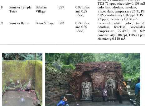
Ph 6.59, conductivity 0.09 ppt, TDS 77 ppm, electricity 0.108 mS. 8 Sumber Temple
Tetek
Belahan Village
297 0.07 L/sec and 0.28 L/sec,
colorless, odorless, tasteless, viscousless, temperature 26°C, Ph 6.85, conductivity 0.07 ppt, TDS 72 ppm, electricity 0.106 mS. 9 Sumber Betro Betro Village 382 0.24 L/sec
and 0.39 L/sec,
brownish white color, turbidy, odorless, brackish, viscousless, temperature 27.4°C, Ph 6.89, conductivity 0.08 ppt, TDS 77 ppm, electricity 0.110 mS.
ICEMINE
IOP Conf. Series: Earth and Environmental Science212 (2018) 012002
IOP Publishing doi:10.1088/1755-1315/212/1/012002
8
Figure 4. Hydrogeological map of Penanggungan volcano and surrounding area
3.3 Cultural Heritage
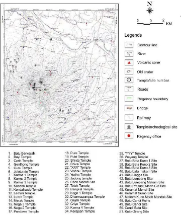
In the study area, there are 51 relic represented as temples and archaeological heritages of the ancient kingdoms of East Java, namely Kahuripan and Majapahit. The kingdoms existed during 10th to 12th
century. The naming of the relics refers to the secondary data of Ubaya Exploration Team that has been done in the year 2012 to 2016. Material used to build the temples is andesite and red soil taken from Penanggungan volcanic products. Distribution of these archaeological sites can be grouped into 4 (four), consisting of group of Penanggungan sites, group of Bekel sites, group of Genting sites, group of Kemuncup site, and group of outer sites (Table 3).
Table 3. Group of Cultural Heritage distribusion
Name of the Group Situation The included cultural heritages
Group of
Penanggungan Sites Upper part slope
IOP Conf. Series: Earth and Environmental Science212 (2018) 012002 doi:10.1088/1755-1315/212/1/012002
Temple, Putri Temple, Pura Temple, Carik Temple, Genthong Temple, Shinta Temple, Jolotundo Temple, Pendawa Temple, Naga 1 Temple, Yudha Temple, Lemari Temple, Merak Temple, and XXX Temple (no name).
Group of Bekel Sites Batu Berwajah, Reco Macan, Kama 2 Temple, Kama 3
Temple, Kendali Temple, and Kendalisodo Temple. Group of Genting
Sites
There are 8 temples: Griya Temple, Kama 4 Temple, Gajah Temple, Dharmawangsa Temple, YYY Temple (no name), Kerajaan Temple, Wayang Temple, and Jedong Temple Group of Kemuncup
Sites Naga 2 Temple, Naga 3 Temple, and Tetek Temple
Group of Outer Part
Bricks cemetery site, ruins of temple site, Batu Lumpang site, Mbah Giri inscription site, Keramat Mencil site, and Keramat Sumo site.
Western part of the foot slope of Penanggungan volcano
Bricks Temple site, Batu Lumpang site, ancient bricks 1 site, ancient bricks 2 site, ancient bricks 3 site, stone temple sites, Lingga stone site, Kutogirang site, and ancient cemetery of
ICEMINE
IOP Conf. Series: Earth and Environmental Science212 (2018) 012002
IOP Publishing doi:10.1088/1755-1315/212/1/012002
10
Figure 6. Map showing distribution of temples and archaeological sites
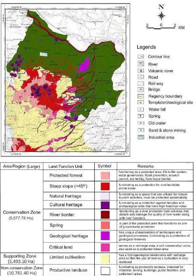
3.4 Conservation Zonation
IOP Conf. Series: Earth and Environmental Science212 (2018) 012002 doi:10.1088/1755-1315/212/1/012002
Figure 7. Map of Conservation Zones of Penanggungan Volcano and Surrounding Area
Conclusions
ICEMINE
IOP Conf. Series: Earth and Environmental Science212 (2018) 012002
IOP Publishing doi:10.1088/1755-1315/212/1/012002
12
joints and fault that is classified into left lateral slip fault, formed due to volcanic activities of Penanggungan volcano
The hydrogeological conditions of Penanggungan area comprises three free aquifers showing intergranular, intergranular and fissure, and fissure aquifers types. The groundwater quality belongs to good classification. There are nine potential springs exist in the study area, that the water can be utilized for fulfilling the fresh water needs of people in the surrounding areas.
There are 51 historical sites of the ancient Kahuripan and Majapahit kingdoms. The distribution of temples and archaeological sites can be grouped into 3 (three) group, they are group of sites on Penanggungan volcano, roup of sites on Bekel dome, group of sites on Genting dome, group of sites on Kemuncup hill, and group of outer sites.
Based on volcanic geology, hydrogeology, and the existence of archaeological sites, the research area can be divided into 3 (three) zoning areas, including conservation zone (5,577.78 Ha), supporting zone (5,493.1 Ha), and unprotected zone (10,781.4 Ha). The conservation zone contains some units of protected forest area, the steep slope area, natural heritage area, cultural heritage area, river border area, springs area, spring area, geological heritage area, and critical land area.
References
[1] Bronto S (2006) Fasies Gunungapi dan Aplikasinya (Volcanic Facies and its Applications), Jurnal Geologi Indonesia, Vol. 1 No. 2 Juni 2006: 59-71
[2] Kusumayudha SB, Pratiknyo P, Purwanto, Riswandi H, Ciptahening AN, Hermawanti N (2018) Fissure structure analysis to unravel groundwater inflow problem in gold mining site of Pongkor area, West Java, Indonesia, Int. Journal of Hydrology Science and Technology, Vol 8 Number 2, 2018: 148-162
[3] Peraturan Daerah Kabupaten Pasuruan No. 12 Tahun 2010 Tentang Rencana Tata Ruang Wilayah Kabupaten Pasuruan Tahun 2009 - 2029. Lembaran Negara RI tahun 2010, No. 12. Sekretaris Daerah Kabupaten Pasuruan. Pasuruan
[4] Peraturan Daerah Kabupaten Mojokerto No. 9 Tahun 2012 Tentang Rencana Tata Ruang Wilayah Kabupaten Mojokerto Tahun 2012 - 2032. Lembaran Daerah Kabupaten Mojokerto tahun 2012, No. 9. Sekretaris Daerah. Mojokerto
[5] Peraturan Daerah Kabupaten Mojokerto No. 11 Tahun 2015 Tentang Cagar Budaya. Lembaran Daerah tahun 2015, No. 15. Sekretaris Daerah Kabupaten Mojokerto. Mojokerto
[6] Peraturan Pemerintah Republik Indonesia No. 26 Tahun 2008 Tentang Penataan Ruang Nasional. Lembaran Negara RI tahun 2008, No. 48. Sekretariat Negara. Jakarta
[7] Peraturan Pemerintah Republik Indonesia No. 43 Tahun 2008 Tentang Air Tanah. Lembaran Negara RI tahun 2008, No. 83. Sekretaris Negara Republik Indonesia. Jakarta
[8] Pratiknyo P (2016) Hidrogeologi Kawasan Cagar Budaya Gunung Penanggungan. Jurnal Ilmu Kebumian Teknologi Mineral, Universitas Pembangunan Nasional Yogyakarta. Vol. 28, No. 1. Yogyakarta.
[9] Santosa S and Suwarti T (1992) Geologi Regional Lembar Malang. Pusat Penelitian and Pengembangan Geologi. Bandung, pp 25
[10] Sidomulyo H (2016) 200 Tahun Eksplorasi Gunung Penanggungan1816 – 2016. Tim Eksplorasi Gunung Penanggungan Universitas Surabaya (UBAYA). Surabaya
[11] Undang – Undang Republik Indonesia No. 11 Tahun 2010 Tentang Cagar Budaya. Lembaran Negara RI tahun 2010, No. 130. Sekretariat Negara. Jakarta
[12] Van Bammelen RW (1949) Geology Of Indonesia. 1sted. Amsterdam : Government Printing Office the Hague Netherland
[13] Van Zuidam RA (1983) Guide to Geomorphologic Aerial Photographic Interpretation and Mapping. ITC. Netherlands