INTEGRATED DIGITAL SURVEY OF THE “FONTANA RUSTICA”
IN THE GARDENS OF THE QUIRINALE.
L. Parisa, W. Troianob
a
Department of History, Drawing, and Restoration of Architecture, Faculty of Architecture, Sapienza University of Rome, Italy - [email protected]
b
Industrial and Civil Engineering Faculty, Sapienza University of Rome, Italy - [email protected]
Commission V
KEY WORDS: Fontana Rustica, Survey, 3d laser-scanner, Photogrammetry, Modeling, Quirinale
ABSTRACT:
The paper illustrates the results of a research on integrated digital survey of the "Fontana Rustica " in the gardens of the Quirinale, artifact somewhat atypical for its particular organical configuration, and whose history is still to be discovered. The activity is performed by Critevat, interdepartmental research center in Rieti, within of the scientific collaboration with the Office for the conservation of artistic heritage of the Quirinale Palace.
The integrated digital survey in recent years has had a strong impulse thanks to the technological development of the shape acquisition instruments. The research has analyzed the problems of interaction and integration of digital data obtainable using the latest digital technologies such as 3D laser-scanner and digital photogrammetry. A further level of research has focused on the possibility of management of 3D models in relation to data obtained by instruments and methods of investigation of different scientific culture such as seismic transmission tomography and thermografy.
1. INTRODUCTION
The research was carried out by Critevat, interdepartmental research center in Rieti of the Sapienza University, (http://w3.uniroma1.it/critevat/) in collaboration with the Office for the conservation of the artistic heritage of the Quirinale.* The Critevat has wanted to experience on a very specific and particular subject the know-out acquired in recent years in the field of diagnostics and monitoring in the environmental, architectural and archaeological heritage through the use of the most modern techniques of survey and digital representation (Paris et al. 2012).
The guidelines of this research were: the integrated use between scanner-laser data and digital photogrammetry; the management of the points cloud as first 3d discrete model and its development in a continuous surfaces model for the knowledge of the shapes; the integration and interaction of digital data coming from the different methods of non-invasive diagnostics such as for example the seismic transmission tomography or detection thermal infrared (Troiano, 2013).
2. THE INTEGRATED DIGITAL SURVEY
2.1. The “Fontana Rustica”
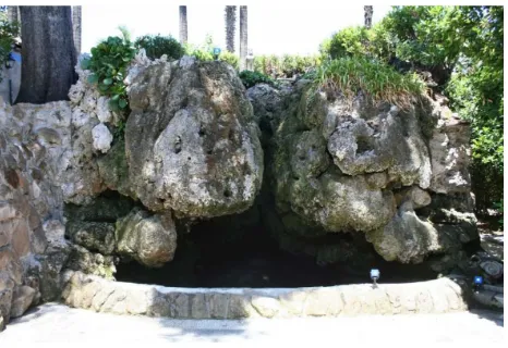
The uniqueness of the subject is first of all in its configuration and its material characteristics: the fountain looks like a rock mass seemingly formless beside to a "strange" hill, the only in the gardens of the Quirinale, bounded on two sides by high retaining walls (fig. 1).
The few historical documents refer to a classic fountain with baths and statues that has been transformed around the sixteenth century (Colalucci, 2013). It has never been done to date a geometric survey. The current configuration is actually the result of a long process of overlapping of limestone masses upon the lichens layers, almost "miraculously" suspended on a
*
A special thanks to Francesco Colalucci and Maria Giuseppina Lauro. Thanks to Louis Godart, director of the Office.
water bath on which it can see some regular geometries which could be the trace of the first fountain.
In order to plan as accurately as possible the restoration is necessary reconstruct the intricate puzzle by the few historical information found until today and understand how it has come to the current configuration.
Figure 1. The “Fontana Rustica”
The shape of the fountain changes constantly and inexorably in virtue of the process of calcification of the vegetable substances present on the surface. In this sense, the “Fontana Rustica” is still a mystery that Critevat, through its contribution wants, to help solve. The mystery is even more dense if you think about the placement of this fountain, in the gardens of one of the most famous and most studied palaces in the world.
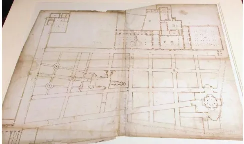
The present structure od the “Fontana Rustica” derives from a first Renaissance fountain constructed in the mid ‘500. It can be assumed its conformation from a watercolor drawing of 1559
(fig. 2) showing the layout of the Villa of Monte Cavallo (before becoming the Quirinale Palace). A few years later there was a first transformation, according to a form more rustic, designed by Curzio Maccarone, known at the time as a builder of rustic fountains. It is hypothesized that the intervention of Maccarone
Figure 2. Watercolor drawing of Villa di Monte Cavallo, about 1559. New York,The Metropolitan Museum of Art, Gift of J. Scholtz and A.B. Scholtz, in memory of Flying Officer Walter Bigelow Rosen, RCAF 1949; 49.92.8).
Figure 3. Some prints. Engraving about 1670; plan about 1625, national museum of Stockholm; Catasto Pio-Gregoriano, plan about 1840, watercolor drawing
has certainly contributed to define the footprint of this rustic fountain although it is certain that the current configuration is far from that supposedly known in ‘600. Surely there were statues and niches that over time have been removed and transferred elsewhere. Surely the water tank had a very different role than that of today, partially hidden.
It 's very likely that the current configuration, more rocky and less architectural, it must be of the renovation works in the 1830s, suggested by comparing two images of the same fountain, the first of 1827, the second of 1840 approximately, where you see a different conformation of the central zone;
more open in the first, more closed in the second (fig. 3). It can therefore be assumed that in the first half of the ‘800 has started a process of uncontrolled calcification that led to the current configuration, documented in some photographs of '900 where the component of the vegetable covering prevails over to the shape of calcareous rock, now very clearly visible from the recent works of cleaning of the surface.
also a problem of representation of the three-dimensional model that deviates from the conventionality typical architectural representation. The model must be able to restore the complexity of surface and its trasformation due to the continuous process of calcification.
2.2 Data acquisition phase
The integrated digital survey in the data acquisition phase is configurated as interaction and integration of three distinct methods: topographic, laser scanning, photogrammetry. In this particular case it was considered not significant the application of the topography, and much has been done on the integration of data acquired by the 3d scanner and by digital photogrammetry. It has been verified as the use of the scanner, that based its technology on the principles of the total station topographic, in practice tends to converge with photogrammetry from which to borrow some well-established methodologies. Among these is the importance given to the acquisition project of data for the proper evaluation of the quality of the product obtained (Paris, 2010).
The data acquisition project for the integrated digital survey is based on three fundamental pillars: the instrumental knowledge, the principal goals of the survey, the knowledge of the place. The instrumental knowledge is important for understanding the potential and the limitations, qualitative and quantitative, of the digital data that can be scanned and the real capacity of interaction and integration of the data.
The goals of the survey may also be considered at this stage unnecessary if we suppose to detect the largest number of possible information to process them later. Experience shows that the reality is often so complex and influenced by internal and external factors then often you have to make choices that can be well-considered only if you know in advance the principal goals, at least in the short term.
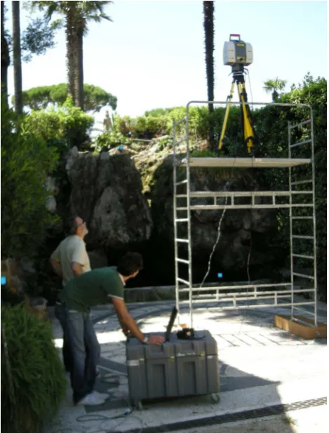
The knowledge of the place is probably the most important aspect and peculiar of the surveyor, where the direct relationship is safeguarded, where it’s possibile to recognize the architectural space in all its physicality and materiality. It’s undoubtedly the moment in which one has the awareness that wrong choices can conditional much the result of the survey. In the case of Fontana Rustica in two days 13 scans were performed, using a laser scanner Leica HDS3000, with a time-of-flight technology, and photographic images were acquired using both the internal machine that an external machine. Were also made numerous photographs not related to scanning with a calibrated digital camera to compensate for the distortions. One of the main problems in the acquisition digitally using the 3D laser scanner is linked to the correct positioning of the stations respect to the environment to detect (fig. 4). The choice of stations (fig. 5) is crucial for a good quality of the discrete model consisting of the so-called points cloud, from which they can then derive the all information metric, the traditional graphical models and the 3D polygonal models.
The quality of the laser scanner data as well as the careful selection of the stations also depends on a number of instrument settings often not given in the reports. One of these is the instrumental resolution, ie the quantity of points in the unit of spherical sector, that is different from the real resolution, ie the one obtained by the intersection of the laser beams with the object. The instrumental resolution (Rsu) can be defined referring to a sphere unitary of radius 1; Rsu = d • r where d is the amount of points per meter, horizontal and vertical (generally equal) and r is the radius of the sphere. If, for example, setting a instrumental resolution of 2 cm with a radius of 10 meters, we have that d is equal to 50, for which Rsu is 500. The knowledge of the instrumental resolution unit is important when we want to estimate in advance the setting time and the amount of information gained.
The real resolution is never homogeneous and varies greatly depending on the shape of the surfaces and the distance of the station. This has two important consequences in the setting of the project: choose of good scan stations positions in order to obtain a real resolution as uniform as possible; choose multiple stations in order to compensate for excessive differences of the resolution once summed the multiple points-cloud data. And again, choose different resolutions, a lower overcoating general, and other partial denser, in function of the specific formal characteristics of the object to be detected.
All the shots were integrated with photographs taken with either a machine inside the instrument and external mounted on a panoramic head.
Figure 4. Acquisition data phases with laser scanner.
Figure 5. The acquisition project with stations and targets position
Thanks to a special kit supplied, the center of the lens of the external camera coincides with the center of projection of the laser beam, thus allowing a perfect match and interchangeability between "internal" photos often not of good quality, and the "external" which is better as resolution and exposition (fig. 6).
Figure 6. Equirectangular image with external camera on Nodal Ninja 3 panoramic head.
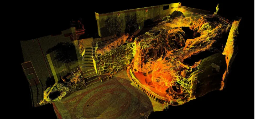
In the specific case of the Fontana Rustica the major problems are derived from the particular conformation of the elements pseudo rock with a deep slit inside, and from the boundary conditions with numerous constraints for the positioning of the instrument. To maximize the quality of the final model two scans are made inside the tank from which it was possible to see a large part of the inner surface, and two scans, one front and one side using a scaffold on wheels to have a view the most optimal possible. To registration all 13 differents points cloud has used the "tilt and turn” targets with the automatic tracking off with millimeter accuracy. As regards the instrumental resolution unitary Rsu was applied an average value equal to 1000 (fig. 7).
2.3 Discrete digital model
An important first three-dimensional model of investigation is the total points-cloud, once deleted all irrelevant informations. About this discrete model we can make some general considerations, also resulting from this particular experience. The considerations relate fundamentally the different modes of use of the data acquired by a laser scanner for the knowledge of an artifact. It may highlight different degrees of management of
a points cloud (fig. 8). The first is undoubtedly represented by the possibility of obtaining metric informations; it should be noted that measures are related only to the single points of the model; points which, unlike a topographic system, are not matching at particular points of the object. The measure of a points cloud therefore is affected by a slight indeterminacy and approximation which is a function of the quality of resolution than evidently by the characteristics of instrumental precision. It is therefore necessary to carefully evaluate the margin of error metric also according to the scale of representation to be taken in the transition from discrete model to the continuous model and to the traditional graphical models.
The metric informations obtainable from a points cloud can easily result in multiple sections, horizontal, vertical or oblique in function of the particular shape of the object. These particular sections however are not able to give back directly information on particular geometric patterns, such as the matematical properties of a line which often comply the architectural space, but must be interpreted through approximation manual procedures.
An artifact of a predominantly sculptural character, as for example the Fontana Rustica, is not affected (or it is little) by this limitation because the overall geometric conformation is not based on mathematical lines and surfaces.
All metric informations deduced from a points cloud can be translated in vector format (and thus can be used with other computer modeling software) or can be converted to raster mode. In the latter case it becomes even more important to carefully evaluate the final result of the survey in function of the different scales of graphic representation with the resulting margin of the error graph.
By a points cloud you can get the orthographic views with reference to various planes; the points cloud resolution is frozen in the pixel resolution of the raster image.
The software that can handle points cloud also allows you to select some specific data, not only metric, for each single point. Such as the value of the reflectance through which is possible to obtain views of the point cloud for intensity maps. The value of reflectance evidently is affected by the nature of the surface but also by the position with respect to the instrument.
In some specific cases the map of intensity can highlight some particularities of the object not visible or perceptible to the naked eye. In the case of Fontana Rustica this map is not particularly significant.
Figure 8. Interation between reflectance and RGB values
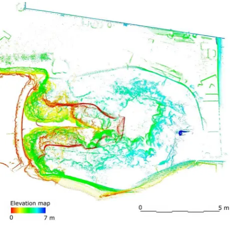
Figure 9. Elevation map
the distance with respect to specific reference planes. The sum of these values determines what is defined as elevation map, ie a map through which you can view with a suitable color scale, the variations in height of the points of the cloud with respect to the reference plane. The same scale applied to vertical planes instead of horizontal is able to display for example for out of plumb of edges or walls, or deformation due to structural instability. The elevation map of the Fountain Rustica applied to the model allows you to see together, in a single plan, a lot of information on the peculiar geometrical shape of rock masses and on the relationship with the original structure visible at the level of the tank (fig. 9).
All this information, from those metrics to those positional, have, as already mentioned, a pure denotative value.
The discrete model of the point cloud, however, has also at the same time the capacity to take a connotative meanings, as a vehicle of deep knowledge of a particular artifact, not only in its geometry but also in the formal and aesthetic aspects.
An important factor in the representation of a points cloud is constituted by the fact that at any point it is possible to combine an RGB value derived from a photographic image. The model in the rendered view is transformed into a real three-dimensional photograph, the effectiveness of which depends on the resolution of the model and on the display resolution . The metric data gives way to the representative quality of the photographic image for which the numerical model is
transformed into a figurative model highly effective communicative and expressive.
The versatility of the digital data is also manifested in the multiple visualizations of the model in function of the different possibilities offered by the software can handle the points cloud. A very important element is the ability to be able to give "body" to a model made only of points very often overlapped in three dimensions, setting views through which we can recognize lines and surfaces, able to highlight the geometric properties and material otherwise not visible.
.
Figure 10. Digital photogrammetry to calcolate the 3d position of theseismic tomography sensor
Figure 11. 3D position of theseismic tomography sensor
Figure 12. Distribution of the number of the raypaths that are directly linked to the quality of the material (High number it
means better quality low number low quality)
Figure 13. Section of the fountain
Figure 14. Hypothesis of overlap of the survey plan with the historical maps. (By Francesco Colalucci)
2.4. Diagnostic data integrations
A further level of research has focused on the possibility of management of 3D models in relation to data obtained by techniques and methods of investigation of different scientific culture. In the first case it is experienced an elastic characterization of the materials through seismic transmission tomography to try to understand what is hidden within the rock mass and if there are elements in support of calcareous concretions surface. The research is based on studies carried out recently by E. Cardarelli & G. Di Filippo. The first data, included in the 3d model, have detected low P velocity values that can be ascribed to caves formed by water seepage and contemporary to the presence of material with elastic mediocre properties that would suggest a hidden structure of mortar and bricks (Cardarelli et al. 2001, 2002, 2013).
Another experiment started was that of the characterization of the surface through the thermal infrared detection performed by G. Sappa & V. Piergrossi. The survey method developed on the fountain allows you to detect in real time the thermal behavior of the surface by highlighting the zones of greater or lesser susceptibility to the limestone formation and thus for the modifiability of the shape.
3. CONCLUSIONS
By combining the survey data (fig. 13) with the historical information it was possible to highlight some elements that relate to the original structures, assuming also a possible overlap with the plants of historical-documentary (fig. 14) in addition to identifying possible ways to more in-depth analysis and in some cases may be invasive, while minimizing the impact on the monument.
The research has shown the great potential of digital technology in the survey of cultural heritage and has identified some possible lines of development.
On the one hand, it was established that, in this case, the digital survey based on a tight integration between photogrammetry and laser scanning technology is the only solution possible to try to create a valid model of investigation. Starting from the study of the external form it was possible to return information on the structure of the apparatus not visible rocky and consequently understand the reason of the transformation project of the original fountain. This will allow for a careful assessment of the conservation strategies, also in view of the mutability over time due to the rapid stratification of calcification processes.
The other element which must be the main objective of the activities of the knowledge of cultural heritage is to be able to interact with a whole series of possible micro invasive or non-invasive investigations to be able to implement in time the basic model by loading new meanings also for the purpose of possible programming strategies for its protection and enhancement.
4. REFERENCES
Paris, L, Liberatore, D., Wahbeh, W. 2012. Digital Re- presentation of Archeological Sites. Recent Excavation at Alba Fucens. In Gambardella C. (ed): Less More Architecture Design Landscape. Atti del X Forum Internazionale di Studi,. Napoli Capri.
Troiano, W. (ed) 2013. La Fontana Rustica del Quirinale. Roma. In printing.
Colalucci, F. 2013. Perché la Fontana Rustica. In Troiano, 2013.
Paris, L. 2010. Quantità e qualità nell'utilizzo dello scanner laser 3D per il rilievo dell'architettura In: X Congreso International Espresiòn gràfica aplicada a la edificaciòn. Alicante, 2, 3 e 4 dicembre 2010, ALCOY, vol. I, p. 279-289
Cardarelli, E., Di Filippo, G. 2013. La Fontana Rustica del Quirinale: caratterizzazione elastica attraverso la tomografia sismica per trasmissione. In Troiano, 2013
Cardarelli, E., De Nardis, R., 2001 Seismic Refraction, isotropic and anisotropic seismic tomography on an ancient monument Geophysical Prospecting Vol. 49, 2 228,240