THE STATUS OF TOPOGRAPHIC MAPPING IN THE WORLD
A UNGGIM - ISPRS PROJECT 2012 - 2015
G. Konecny, U. Breitkopf, A. Radtke
Institute of Photogrammetry and GeoInformation, Leibniz Universität Hannover, Germany
ISPRS-UN-GGIM Forum
KEY WORDS: Topographic mapping, Global status of mapping
ABSTRACT:
In December 2011, UNGGIM initiated a cooperative project with ISPRS to resume the former UN Secretariat studies on the status of topographic mapping in the world, conducted between 1968 and 1986. After the design of a questionnaire with 27 questions, the UNGGIM Secretariat sent the questionnaires to the UN member states. 115 replies were received from the 193 member states and regions thereof. Regarding the global data coverage and age, the UN questionnaire survey was supplemented by data from the Eastview database. For each of the 27 questions, an interactive viewer was programmed permitting the analysis of the results. The authoritative data coverage at the various scale ranges has greatly increased between 1986 and 2012. Now, a 30% 1:25 000 map data coverage and a 75% 1:50 000 map data coverage has been completed. Nevertheless, there is still an updating problem, as data for some countries is 10 to 30 years old. Private Industry, with Google, Microsoft and Navigation system providers, have undertaken huge efforts to supplement authoritative mapping. For critical areas on the globe, MGCP committed to military mapping at 1:50 000. ISPRS has decided to make such surveys a sustainable issue by establishing a working group.
1. ORIGINS OF THE PROJECT
In 1986, the Department of Technical Cooperation for Development of the United Nations Secretariat completed the last survey on the „Status of World Topographic and Cadastral Mapping“. The results of the survey were published by the United Nations, New York, 1990, in World Cartography, Vol. XIX. The text was submitted by the UN Secretariat as document E/CONF 78/BP7, in 1986, prepared by A.J. Brandenberger and S.K. Ghosh, of the Faculty of Forestry and Geodesy at Laval University, Quebec, Canada. It referred to previous surveys submitted by the Department of Technical Cooperation for Development of the United Nations Secretariat, in 1968 published in World Cartography XIV, and in 1974 and 1980, published in World Cartography XVII.
The paper published in World Cartography XIX in 1990 summarized the progress made in topographic mapping across the globe between 1968 and 1980 in 4 scale categories:
range I; scales between 1:1000 and 1: 31 680 range II; scales between 1:40 000 and 1:75 000 range III; scales between 1:100 000 and 1:126 720 range IV; scales between 1:140 000 and 1:253 440
These ranges represent the more recently standardized scales: range I; scales between 1:1000 and 1: 31 680
range II; scales between 1:40 000 and 1:75 000 range III; scales between 1:100 000 and 1:126 720 range IV; scales between 1:140 000 and 1:253 440
range I range II range III range IV area of survey 1986 90.1% 97.4% 97.0% 97.75% 1986 map coverage 17.9% 49.3% 46.4% 87.5% 1980 map coverage 13.3% 42.2% 42.2% 80.0% 1974 map coverage 11.6% 35.0% 40.5% 80.5% 1968 map coverage 7.7% 23.4% 38.2% 81.0% Since the last survey in 1986, considerable progress has been made in data coverage:
range I range II range III range IV 2012 map coverage 33,5% 81.4% 67.5% 98.4%
Chart 1: Percentages of total world area covered in each scale category, 1968-1974-1980-1986-2012
While the surveys presented in 1986 did not concentrate on map revision on a global basis, they nevertheless derived an update rate for the four scale ranges:
range I range II range III range IV update rate 1986 3.2% 1.8% 2.7% 3.6%
Chart 2: Average map age in years counting from 2012
2. THE UNGGIM-ISPRS PROJECT
The United Nations Regional Cartographic Conferences (UNRCC) for the Americas and for Asia and the Pacific nevertheless continued to recommend to the Secretariat to continue the studies on the global status of mapping. One of these resolutions of the UNRRCC for the Americas, in 2009, gave the mandate to the Secretariat for a new survey.
This happened at the time when UNGGIM (United Nations Global Geospatial Information Management) was created as a new structure.
ISPRS approached the director of UNGGIM, in 2011, to start a joint project on the survey of the status of topographic geospatial information,
• because the issue is of global interest
• because new technologies, such as GNSS (GPS, GLONASS), digital aerial mapping, high resolution satellites for mapping, digital photogrammetry and GIS have taken over as new mapping methodologies • because large private organizations, such as the
navigation industry (HERE, TomTom), Google Earth and Microsoft Bingmaps, have entered the mapping effort, which was previously the domain of the national mapping agencies.
The project was approved in December 2011, by Dr. Paul Cheung, director of UNGGIM at that time, who nominated Dr. Amor Laaribi as UNGGIM contact, and by Chen Jun, President of ISPRS, who nominated Prof. Gottfried Konecny, of Leibniz University Hannover, as ISPRS contact.
In January 2012, a questionnaire to the UN member states was designed, mutually discussed, translated to French, Russian and Spanish and mailed to the contacts of the UNGGIM Secretariat in the UN member states. Ms. Vilma Frani, of the UNGGIM Secretariat, sent the replies to Leibniz University Hannover, where they were placed in a database, designed by Uwe Breitkopf, for further analysis.
3. THE QUESTIONNAIRE
The jointly designed questionnaire consists of five parts, including 27 Questions:
• PART A: Background Information
• PART B: National Topographic Mapping Coverage • PART C: National Imagery Acquisition
• PART D: National Surveying and Cadastral Coverage • PART E: Organization
Until June 2015, altogether 115 responses have been received from 193 UN member states or regions thereof. In addition, there are 51 non-UN member countries and territories which are also covered by map data. These map data for 244 UN member states and regions were generated in UN member states, but
these have, in general, no direct responsibility for mapping these territories.
Figure 1 shows the 115 states or regions from where replies have been received, which have answered the UNGGIM-ISPRS questionnaire.
Figure 1: 115 countries have replied the Questionnaire until June 2015 (not all country names are visible
4. CONTENT OF THE DATABASE
While not all of the 27 questions need to be answered globally, this is, however, important for questions 1 and 2, since they characterize the global data coverage at the different scale ranges and the age of the data.
To assess the global status of map coverage, the Eastview database is a fundamental component to answer these questions. Dr. Kent Lee, CEO of Eastview has kindly agreed to make the missing data available from their database.
Besides Eastview, other sources were analyzed to fill the gaps in the study and estimate global coverage. These include UN reports accompanying the questionnaires, internet portals for national mapping data, the cartographic database of the German State library of Berlin, based in part on the Geokatalog of the map vendor ILH Stuttgart, and others. See Appendix II to IV for examples.
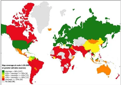
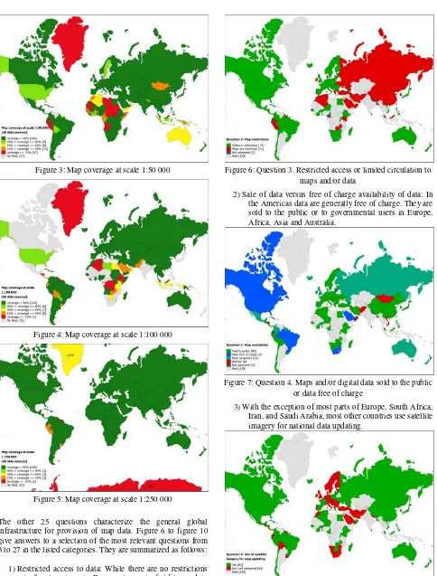
Regarding question 1, figure 2 to figure 5 show the global coverage in the scale ranges 1: 25 000 or greater, 1: 50 000, 1: 100 000 and 1: 250 000.
Figure 3: Map coverage at scale 1:50 000
Figure 4: Map coverage at scale 1:100 000
Figure 5: Map coverage at scale 1:250 000
The other 25 questions characterize the general global infrastructure for provision of map data. Figure 6 to figure 10 give answers to a selection of the most relevant questions from 3 to 27 in the listed categories. They are summarized as follows:
1)Restricted access to data: While there are no restrictions in the Americas, in Europe, in most of Africa and in Oceania, restrictions to the data for the public exist in the Russian Federation and in most parts of Asia (e.g. China, Iran, and Saudi Arabia).
Figure 6: Question 3. Restricted access or limited circulation to maps and/or data
2)Sale of data versus free of charge availability of data: In the Americas data are generally free of charge. They are sold to the public or to governmental users in Europe, Africa, Asia and Australia.
Figure 7: Question 4. Maps and/or digital data sold to the public or data free of charge
3)With the exception of most parts of Europe, South Africa, Iran, and Saudi Arabia, most other countries use satellite imagery for national data updating.
4)Crowd sourcing is only introduced in the USA, France, Spain, Poland and Finland.
Figure 9: Question 6. Use of crowd sourcing for national data revision and map updating
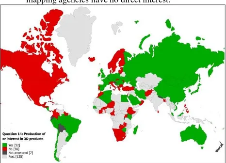
5)Interest in 3D mapping is prevalent in Europe, China, the Russian Federation, Australia and Brazil, while in North America, Scandinavia and South Africa governmental mapping agencies have no direct interest.
Figure 10: Question 14. Production or intention to produce 3D urban and rural landscape models and/or product visualization
5. MAPPING CONTRIBUTIONS BY PRIVATE INDUSTRY
As has been demonstrated, official and authoritative mapping by governments provides a reliable geospatial infrastructure, which is used for many public and private applications, but which is costly, difficult and slow to maintain. For that reason, private enterprises have succeeded to launch several initiatives to provide faster update solutions in areas which require fast update solutions. These are based on different cost and accuracy models for specific applications which require fast updates. These applications do not replace official authoritative cartography, but they supplement it, as all such efforts utilize official cartographic products as a base to start their value added operations.
5.1 Google
Google´s prime aim is to provide a location based information system for uses of the public. What the general user wants is quick orientation about how to locate a specific object, such as a landmark, a store, a restaurant or a service provider and how to drive to it.
Geometric accuracy within the context of the neighbourhood topography is of lesser importance than the addressability and the access by roads or pathways. In general, business advertising provides for the revenue to establish and to maintain the system.
Google Inc. operates by different projects, of which the following are the most important from the cartographic point of view.
5.1.1 Google Earth: Existing orthophotography coverage, with ground sample distances between 0.1m and 0.5m, as well as high resolution satellite imagery coverage with ground sample distances (GSD) between 0.5m to 2m and beyond, provide the geometric background image information which can be interpreted by the user with respect to the searched objects, such as buildings, roads, vegetation, water surfaces. While ortho images have a high geometric accuracy related to ground features commensurate with the GSD, this is not so for building tops and tree tops. Geometric accuracy even deteriorates more for high resolution satellite imagery, since most of these images have been acquired with inclinations with respect to the vertical, unless stereo imaging permitted the generation of ortho imagery. The coverage is global for all land areas.
5.1.2 Google Maps: Google Maps is a product usually derived, wherever possible, from authoritative cartography. It has been designed to supplement Google Earth with a cartographic output containing place names, road names and building addresses. It serves the ideal function of superimposing images with line graphics. Even though Google Maps may be derived from authoritative cartography, the feature content is much less elaborate and reduced to the intended geolocation function.
5.1.3 Google Street Map: Google Street Map has been developed as a tool to image buildings and streets with street furniture along urban roadways. This is done by vehicle based cameras, located by GNSS signals. In some communities, the imaging of building facades has met resistance by some members of the population, which did not wish to show them to the public on the web. Nevertheless, Google has pursued street mapping for the sole reason to update the Google Maps content as an internal operation.
5.2 Microsoft Bingmaps
Microsoft considered Google to be their strongest competitor, while Bingmaps has the same objectives as the Google efforts. Therefore, care has been taken to achieve a higher resolution and a more accurate geometry than Google Earth.
This was possible by limiting the area of interest to the continental USA and to Western Europe, where there were no flight restrictions. Furthermore, the imagery used for Bingmaps consisted solely of digital aerial imagery flown by the company owned Vexcel Ultracam cameras.
The coverage of the countryside for the USA and for Western Europe was completed at 30cm GSD, and the urban areas were imaged at 15cm GSD. Whether the originally foreseen updates of every 3 years can be achieved, as planned, is still an open issue. There has been a recent announcement that Microsoft turned over Bing Maps technology to UBER.
5.3 HERE
When the Finish company Nokia bought Navteq, the global car navigation system efforts were continued by the subsidiary HERE.
voice guided navigation and 44 countries with live traffic services.
Of interest are roads and points of interest. This also includes unidirectional restrictions of traffic flows.
In Europe, 15% of the map´s content is updated every year, modifying or adding 1.1M km of roads, creating 700 000 new points of interest and adding 600 000 speed cameras.
In the Russian Federation 800 000 km of roads change after 6 months, and so do 120 000 street names, 22 000 turn restrictions, 3400 one way streets, 38 000 speed limits and 8700 directional street signs.
5.4 TomTom
TomTom has road navigation coverage for 118 countries extending over North America, Brazil, Argentina, Europe, the Russian Federation, India, Indonesia, Thailand, Australia, New Zealand, West and South Africa.
6. MAPPING BY MILITARY ORGANIZATIONS
As during the cold war period, when the US and the USSR military organizations considered it their goal to conduct mapping operations in what they considered to be crisis areas, this practice was recently revived by about 30 nations from Europe, North America, Australia, New Zealand, Japan, Rep. of Korea and South Africa when they launched the Multinational Geospatial Co-Production Program MGCP. The goal of this program is to generate up-to-date 1:50 000 digital maps for potential crisis areas of the globe in Asia, Africa, the Middle East, the West Indies and the Pacific Ocean. Benefitting from this activity is the UN cartographic section, which utilizes these maps to create information for crisis mitigation.
7. OTHER MAPPING EFFORTS
• OpenStreetMap is the voluntary Crowd sourcing attempt to update authoritative map content by the public. It started in Great Britain with the establishment of the OpenStreetMap Foundation. Anyone can become a member for a small fee. The Foundation has many working groups to monitor quality and progress. It has been enthusiastically promoted in Germany, the Netherlands, Japan, the USA and Australia. Map updating or mapping covers the entire globe but to be publicly recognized it must be integrated into authoritative mapping to guarantee feature content, accuracy and local completeness by authoritative quality control. Until this is assured, the attempt lacks legal support.
• Scan Map by Eastview is a new commercial venture to integrative authoritative mapping with population statistics.
8. SUMMARY OF RESULTS
• 115 UN Member countries have responded to the 2012-2015 UNGGIM-ISPRS Survey. It has been shown, that nearly all reporting countries have modernized their facilities to adopt modern GNSS, digital imaging and GIS technology in their operations, which are still handicapped by lack of funding and staff shortages. • While in 1986 the world was basically covered by 1:250
000 maps, progress in technology has now made it possible to state that topographic mapping of the
globe at 1:50 000 scale, relevant to sustainable development, has been reached.
• There are still gaps in providing updated information in developing countries. These need to be closed with a goal of no data to be older than 5 years.
• New technologies, such as those used by Google and by Yandex, could help to reach this goal in priority areas.
9. FUTURE ACTIVITIES
• ISPRS has created working group IV-2 to accompany the UNGGIM-ISPRS project.
• This working group has successfully provided the needed discussion forum for the task.
• It will be the future goal of this group to assure that the data collection and analysis will be sustainable by cooperating with UNGGIM and UN-GEO.
• A near goal will be the expansion of the work to include global land cover mapping as a task.
ACKNOWLEDGEMENTS
Acknowledgements of support for the project are to the ISPRS Scientific Initiative Program for 2014 and 2015, to the Director of the Institute for Photogrammetry and GeoInformation, Prof. Christian Heipke, and to the German Research Foundation DFG.
REFERENCES
UN Secretariat document E/CONF78/BP7 1986, prepared by A. J. Brandenberger & S.K. Ghosh, published in World Cartography XiX, 1990
UN Secretariat document E/CONF78/BP8 1986, prepared by G. Konecny, published in World Cartography XIX, 1990
Global Geospatial Information and High Resolution Global Land Cover/Land Use Mapping. Proceedings of ISPRS WG IV/2 Workshop, April 2015, Novosibirsk
The Global Status of Topographic Mapping, Gottfried Konecny, pp. 4 - 20
The Global Status of Topographic Mapping: Technical Background, Uwe Breitkopf, p. 21
The Current Status of Mapping in the World - Spotlight on Pacific Islands, John Trinder, pp. 22 - 32
High Resolution Global Land Cover/Land Use Mapping. Current Status, Klaus U. Komp, pp. 33 - 47
ISBN 978-80-01-05725-4 ISBN 978-5-87693-800-8
APPENDIX
Various project results can be viewed as an interactive map at: